 | Редактирование фотоальбома |
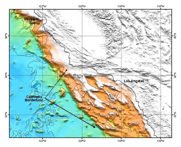
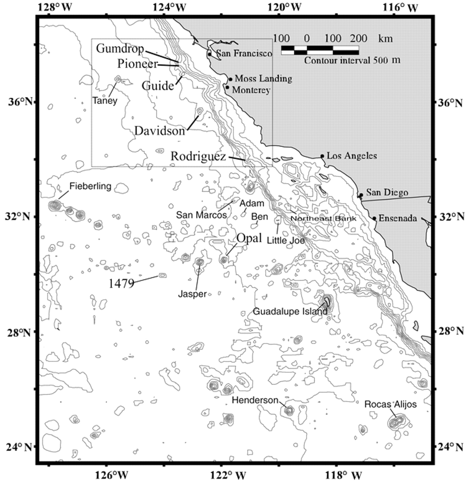
Map of the California Borderland, which is a broad area of basins and ranges with some islands off Southern California. Map © MBARI 2006 - http://www.mbari.org/volcanism/Margin/Marg-Borderland.htm |
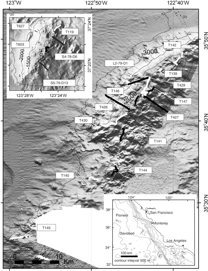
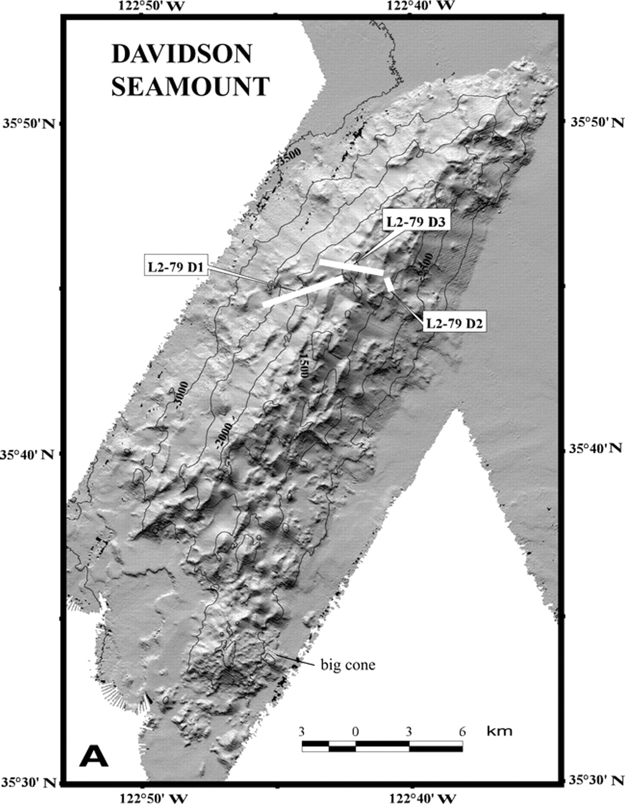
Illuminated Simrad EM300 bathymetric images of (a) Pioneer and (b) Davidson seamounts showing ROV Tiburon dive tracks and USGS dredge locations. Black lines indicate tracks where xenoliths were recovered. Contour interval is 500 m. Inset map shows location of seamounts relative to the continental margin -http://petrology.oxfordjournals.org/content/48/5/829.full. |
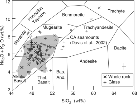
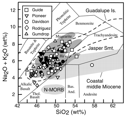
Whole-rock and glass compositions of lavas recovered from Davidson Seamount on an alkali vs silica plot that shows the range from tholeiitic and mildly alkalic basalt to trachyte. Hawaiite compositions are most abundant. Field of lava compositions from five seamounts offshore central California (Davis et al., 2002) includes some from Davidson and Pioneer Seamount. Data are normalized to 100%. Analytical errors are indicated. Classification is that of Cox et al. (1979). Haw, hawaiite; Bas. And., basaltic andesite; Thol., tholeiitic - http://petrology.oxfordjournals.org/content/48/5/829.full |
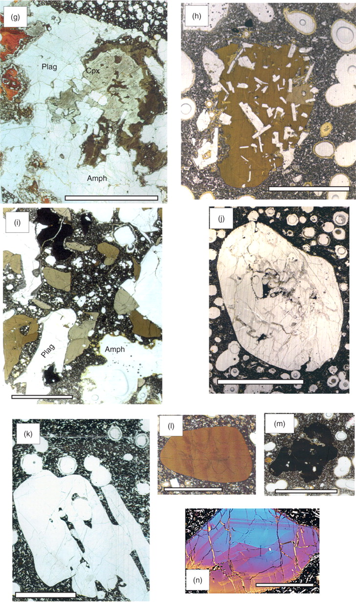
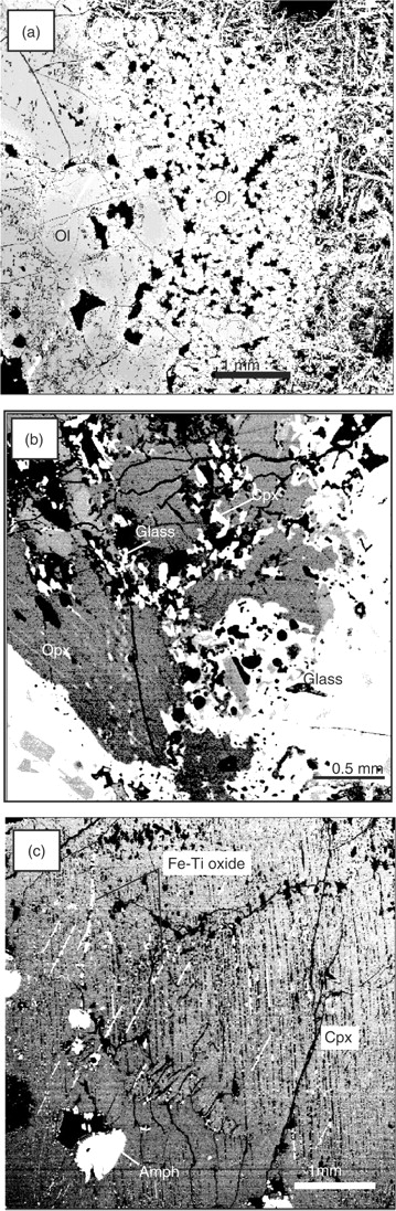
Photomicrographs of thin sections of xenoliths and megacrysts: (a) dunite (D5) with >Fo90 olivine; (b) porphyroclastic lherzolite (L1) in vesicular glass; (c) pyroxenite (P1) with large spinel crystal; (d) troctolite (T1) in vesicular lava; (e) amphibole-free gabbro (Gn1) with low-K2O plagioclase; (f) amphibole-free gabbro (Gn2) with high-K2O plagioclase; (g) gabbro with secondary amphibole replacing clinopyroxene; (h) gabbro (Gp6) with euhedral plagioclase poikilitically enclosed in amphibole; (i) amphibole gabbro (Gp7) partially disaggregated by the host lava; (j) rounded anorthosite (A5) of labradorite without reaction rim; (k) angular andesine anorthosite, embayed along cleavages; (l) ovoid amphibole megacryst (M1); (m) amoeboid Fe–Ti oxide megacryst (M5); (n) compositionally zoned clinopyroxene (M6) in cross-polarized light. Scale bar represents 5 mm -http://petrology.oxfordjournals.org/content/48/5/829.full. |
Back-scattered electron (BSE) images: (a) the mosaic formed by small iron-rich olivine crystals along margins of a dunite xenolith (D3); (b) clinopyroxene occurring as small crystals and as exsolution lamellae in orthopyroxene of lherzolite L1; (c) amphibole inclusions and Fe–Ti oxide lamellae cross-cutting clinopyroxene with orthopyroxene lamellae in gabbro xenolith Gs2 -http://petrology.oxfordjournals.org/content/48/5/829.full |
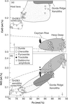
Variation of olivine composition (mole% Fo) vs (a) CaO and (b) NiO content for magnesian olivine of dunite, lherzolite, and pyroxenite xenoliths relative to those of ocean crust or alkalic gabbro (Gn2 and Gn3). Compositions of olivine from the Hess Deep (Allan & Dick, 1996), in xenoliths from Cayman Rise (Elthon, 1987) and Gorda Ridge (Davis & Clague, 1990), as well as in the host lavas are shown as fields for comparison. -http://petrology.oxfordjournals.org/content/48/5/829.full |
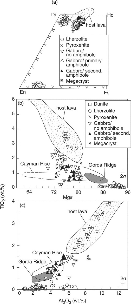
Pyroxene compositions shown in (a) Ca–Mg–Fe ternary, (b) TiO2 vs Mg-number and (c) TiO2 vs Al2O3 plots. Mantle xenoliths are highly magnesian and exceedingly low in TiO2 over a narrow range of Al2O3, whereas xenoliths of alkalic affinity have high concentrations of these two oxides. Ocean crust xenoliths are intermediate in composition. It should be noted that the salitic pyroxene compositions of alkalic samples extend beyond the Di–Hd boundary because of their high CaO content (Basaltic Volcanism Study Project, 1981)-http://petrology.oxfordjournals.org/content/48/5/829.full |
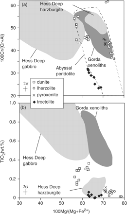
Compositions of spinel in dunite, lherzolite, and troctolite xenoliths in terms of (a) Cr-number and (b) TiO2 vs Mg-number. The low-Ti spinel of the mantle xenoliths suggests depletion comparable with that of the Hess Deep harzburgite. The ocean crust spinel is somewhat lower in Ti than in the Hess Deep gabbro or Gorda Ridge xenoliths. Except for the higher Cr-spinel of lherzolite L1, all plot within or near the field for abyssal peridotite spinel of Dick & Bullen (1984).-http://petrology.oxfordjournals.org/content/48/5/829.full |
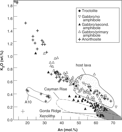
Plagioclase compositions show a trend of higher K2O with decreasing An content for the xenoliths of alkalic affinity. The ocean crust gabbros have plagioclase compositions that overlap with those from Cayman Rise and Gorda Ridge but most are less calcic than the N-MORB xenoliths from the Gorda Ridge. Plagioclase compositions from Hess Deep are off scale (>An70). -http://petrology.oxfordjournals.org/content/48/5/829.full |
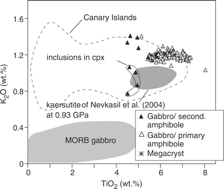
Amphibole compositions of megacrysts, alkalic gabbros, and as secondary replacement in ocean crust gabbros on a K2O vs TiO2 (wt%) plot. The largest amount of variation is found in the inclusions partially replacing clinopyroxene in ocean crust xenoliths (Gs2). However, compared with amphibole compositions of xenoliths from the Canary Islands (Neumann et al., 2000), they cluster within a narrow compositional range. Compositions of amphibole in MORB gabbro (Cannat et al., 1997; Gaggero & Cortesogno, 1997) are significantly lower in TiO2 and K2O. -http://petrology.oxfordjournals.org/content/48/5/829.full -http://petrology.oxfordjournals.org/content/48/5/829.full |
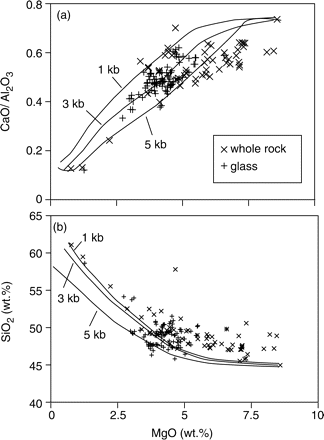
Liquid lines of descent for Davidson Seamount lavas calculated with the MELTS program show (a) CaO/Al2O3 vs MgO strongly decreasing, indicating significant clinopyroxene fractionation. (b) SiO2 vs MgO shows that silica content decreases at higher pressure, making it difficult to produce trachyte at greater depths.-http://petrology.oxfordjournals.org/content/48/5/829.full |
Bathymetric map showing location of volcanic seamounts offshore central California to Baja California. Location of Figure 2 enclosed in box -http://gsabulletin.gsapubs.org/content/114/3/316.figures-only |
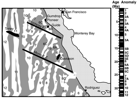
Interpretation of magnetic anomalies (white) offshore central California. Modified from Atwater and Severinghaus (1989) with time scale of Cande and Kent (1995). Locations of seamounts indicated in black. F.Z.—fracture zone -http://gsabulletin.gsapubs.org/content/114/3/316.figures-only |
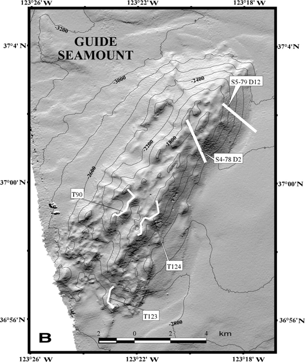
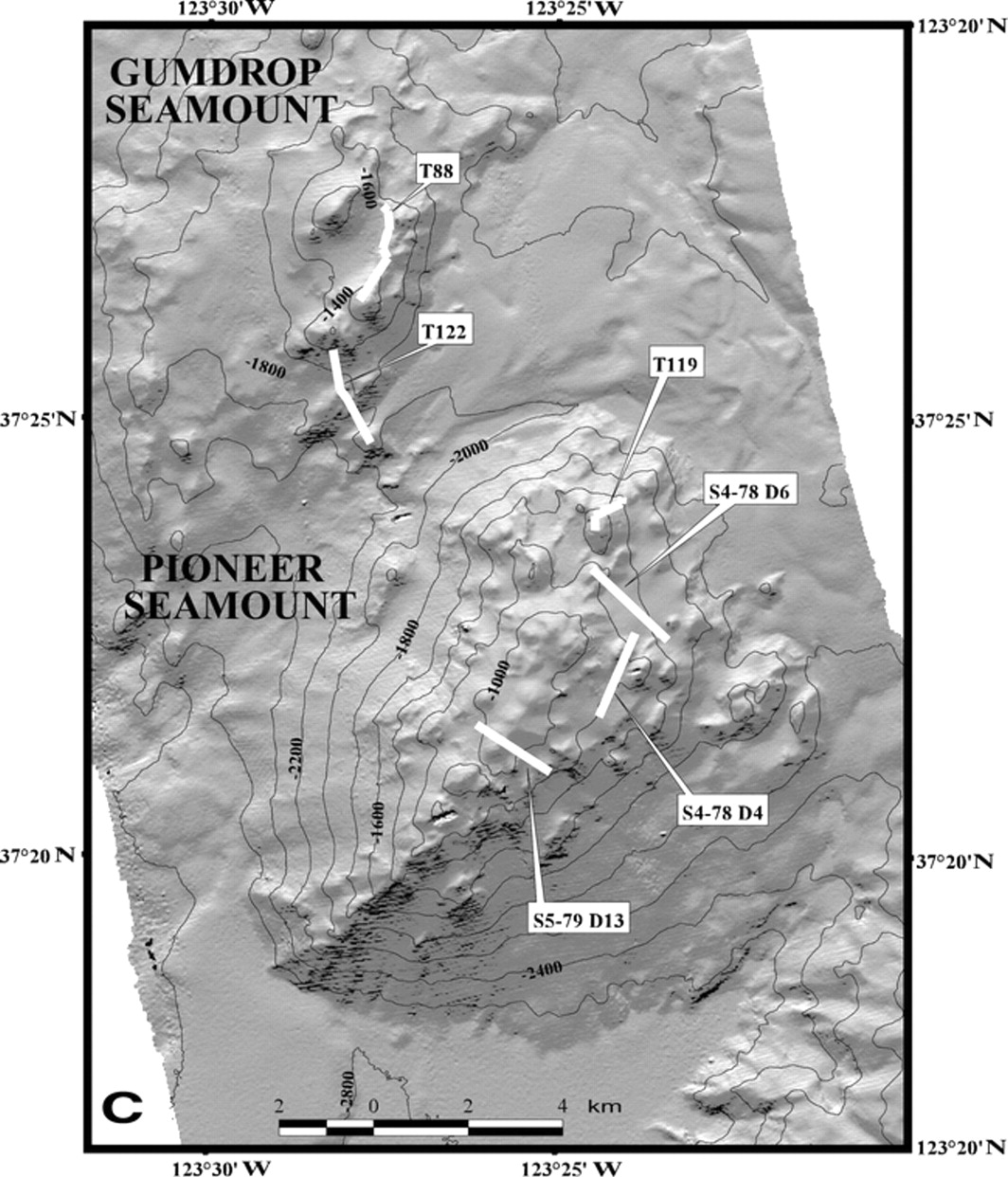
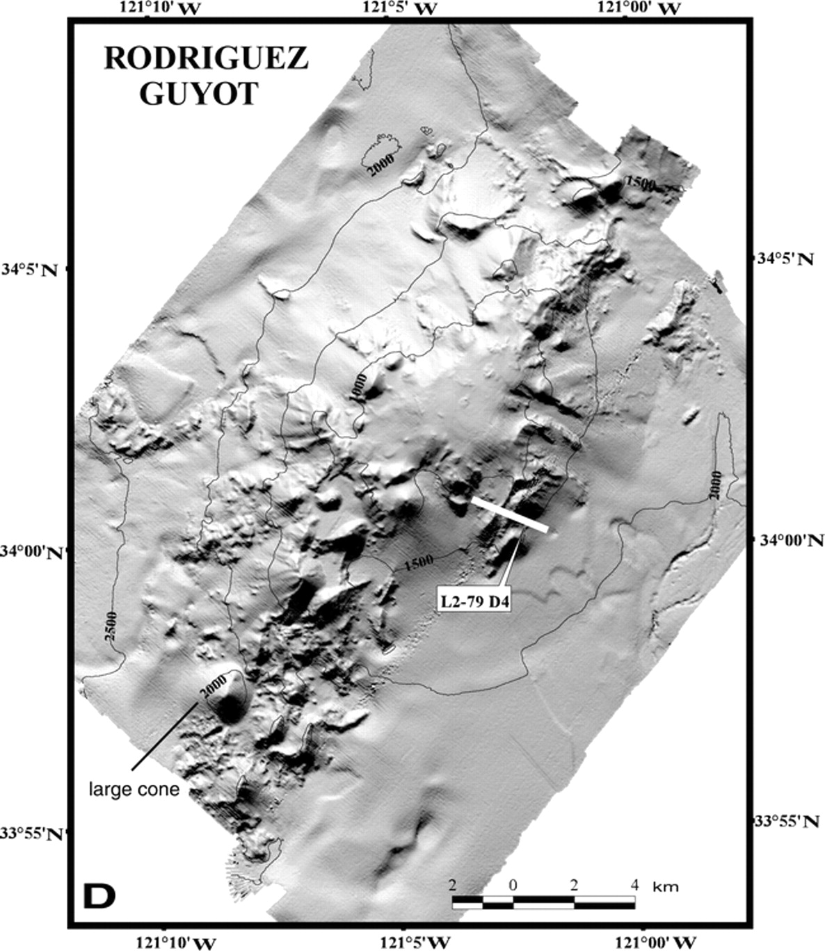
Illuminated Simrad EM300 bathymetric images of continental-margin volcanoes offshore central and southern California, showing dredge and ROV tracks (white). (A) Davidson Seamount, (B) Guide Seamount, (C) Gumdrop and Pioneer Seamounts, and (D) Rodriguez Guyot. Contour interval for Davidson and Rodriguez is 500 m; that for others is 200 m-http://gsabulletin.gsapubs.org/content/114/3/316.figures-only |
|
|
|
Alkalis vs. silica plot for volcanic rocks (open symbols) and glasses (filled symbols). Compositions of volcanic rocks from Jasper Seamount (Gee et al., 1991), Guadalupe Island (Batiza, 1977a, 1977b), and middle Miocene volcanic rocks from onshore coastal California (Weigand and Savage, 1993; Cole and Basu, 1995) are shown for comparison. Data normalized to 100%. Classification of Cox et al. (1979). Bas. And.—basaltic andesite, Haw—hawaiite, N-MORB—normal mid-oceanic-ridge basalt, Smt.—seamount, Thol.—tholeiitic -http://gsabulletin.gsapubs.org/content/114/3/316.figures-only |
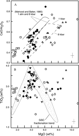
A) CaO/Al2O3 and (B) TiO2 vs. MgO shows large amount of scatter at low and high MgO content. Calculated liquid-lines-of-descent for 1 kbar and 8 kbar (dashed, Ghiorso and Sack, 1995) suggest fractionation over a range of pressures. Experimental study of mildly alkalic basalt by Mahood and Baker (1986) shows a similar pattern. Crystal-fractionation trend observed for volcanic rocks from the Galapagos spreading center (GSC) is shown for comparison (data from Perfit et al., 1983). Symbols as in Figure 4-http://gsabulletin.gsapubs.org/content/114/3/316.full |
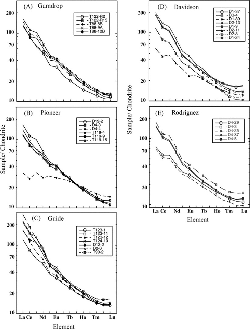
Chondrite-normalized REE patterns for continental-margin volcanoes show mostly light-REE (LREE)–enriched patterns typical of alkalic basalt. Normalizing values from Boynton (1984)-http://gsabulletin.gsapubs.org/content/114/3/316.full |
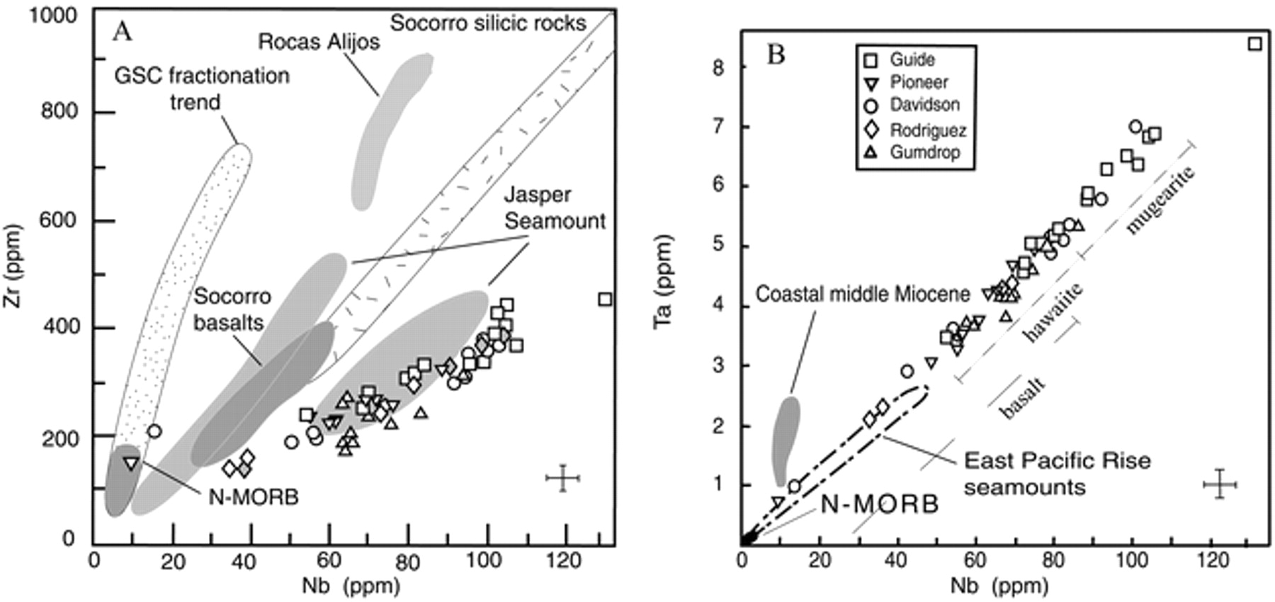
(A) Zr vs. Nb abundances of continental-margin volcanoes studied here (symbols as in Fig. 4) and in samples from Rodriguez (gray-shaded diamonds; Davis et al., 1995). The trend of these volcanic rocks is similar to that of the alkalic summit basalts from Jasper Seamount. Compositions of mildly alkalic lavas from Socorro Island, Mexico (Bohrson, 1993), and compositions of MORB from the Galapagos spreading center (GSC) (Perfit et al., 1983) are shown for comparison. (B) Ta vs. Nb abundances of the continental-margin volcanoes in this study show a narrow trend collinear with—but typically showing much higher values than—the trend of lavas from near-ridge seamounts at the East Pacific Rise (Niu and Batiza, 1997). Low Ta and Nb abundances of middle Miocene basalts from onshore coastal California (Cole and Basu, 1995) are compatible with a subduction-related signature. N-MORB (normal mid-oceanic- ridge basalt) values from Sun and McDonough (1989)-http://gsabulletin.gsapubs.org/content/114/3/316.full |
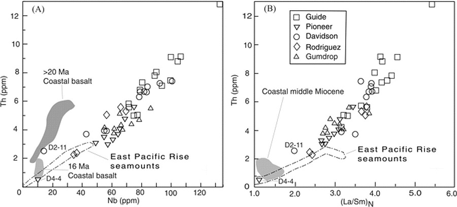
(A) Th vs. Nb and (B) Th vs. (La/Sm)N are positively correlated but show considerable scatter. Except for the tholeiitic basalt from Pioneer Seamount (D4–4) and the andesite (D2–11) from Davidson Seamount, the middle Miocene (16 Ma) and middle Tertiary (>20 Ma) basalts of onshore coastal California have lower Nb and higher Th (Cole and Basu, 1995) than those from the continental margin. High (La/Sm)N of samples (compared to East Pacific Rise seamounts) with MORB-like isotopic compositions suggest a small degree of partial melting -http://gsabulletin.gsapubs.org/content/114/3/316.full |
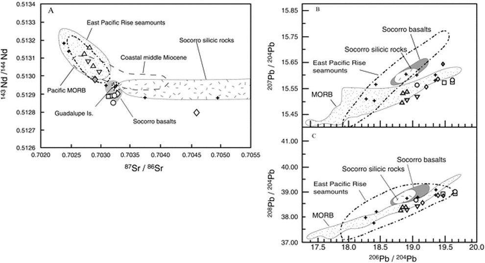
Isotopic compositions of continental-margin volcanoes. (A) 87Sr/86Sr vs. 143Nd/144Nd, (B) 206Pb/204Pb vs. 207Pb/204Pb, and (C) 206Pb/ 204Pb vs. 208Pb/204Pb. Crosses are compositions from seamounts off southern California (Davis et al., 1995). MORB field from Graham et al. (1988) and White et al. (1987); fields for Socorro Island, Mexico, from Bohrson and Reid (1995). Field for middle Miocene basalts of onshore coastal California from Cole and Basu (1995). Symbols for analyses from this study are as in Figure 4-http://gsabulletin.gsapubs.org/content/114/3/316.full |
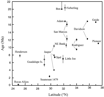
Age vs. latitude plot for volcanoes offshore California and Baja California indicates multiple episodes of volcanism that are generally younger southward. Data from this study shown as filled squares, and data for offshore southern California seamounts (open squares) from Davis et al. (1995). Other data (circles) and sources: for Guadalupe Island from Batiza et al. (1979); for Henderson Seamount from Honda et al. (1987), for Jasper Seamount from Pringle et al. (1991), for Northeast Bank from Bohrson and Davis (1994), and for Fieberling from Lonsdale (1991)-http://gsabulletin.gsapubs.org/content/114/3/316.full |
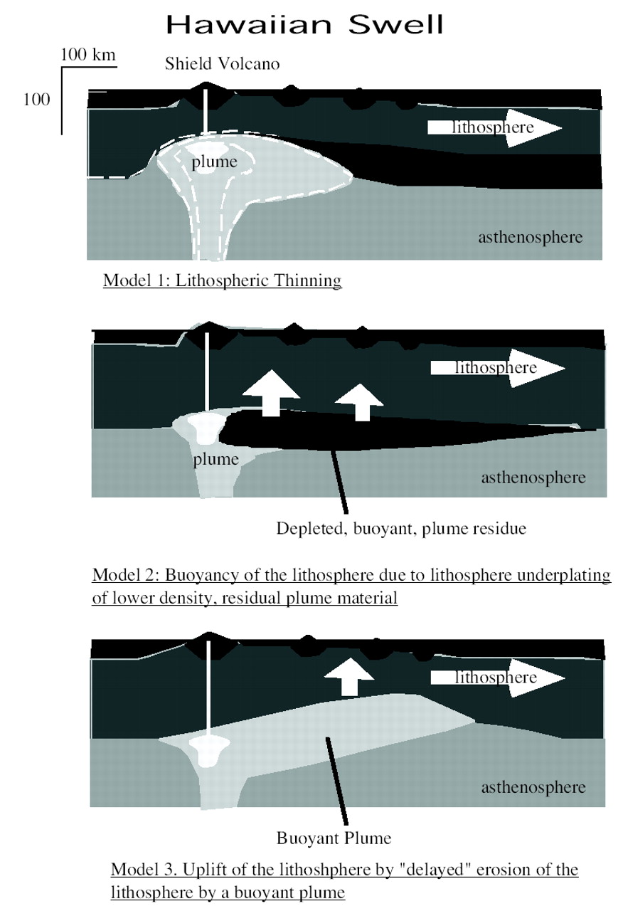
This cartoon shows the three classes of geophysical models that explain the formation of the Hawaiian Swell due to plume-lithosphere interaction. Most noteworthy is that all three models require plume residues and/or melt-derived cumulates to replace or plate the basal lithosphere. Model 1 shows lithospheric thinning due to thermal erosion of the base of the lithosphere. The isotherm at the base of the lithosphere prior to reaching the plume is generally thought to be at ~1300 °C (e.g., Ribe and Christensen 1999). The core of the plume is generally at a temperature of ~1600 °C (cf., Watson and McKenzie 1991; Ribe and Christensen 1999), The dashed contours within the plume are isotherms, and the central isotherm is at ~1500 °C (Watson and McKenzie 1991). Models 2 and 3 provide alternate mechanisms for the Hawaiian Swell and are discussed in the text.-http://ammin.geoscienceworld.org/cgi/content/full/90/5-6/871?ijkey=643e0ed80e548a5efd0b952fb5420158582dc91c |
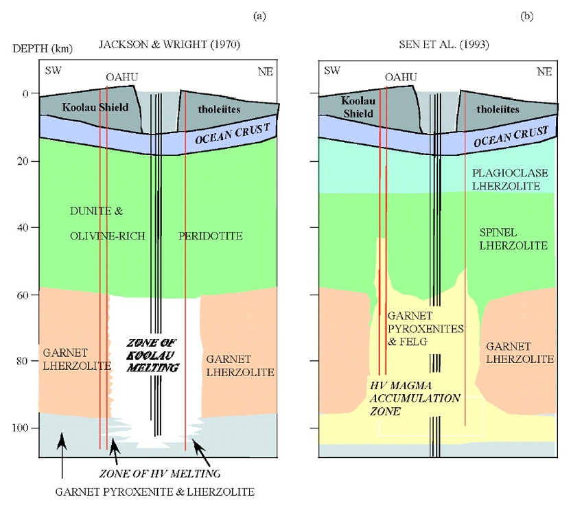
A) An early petrologic model for the Oahu lithosphere and magma generation (Jackson and Wright 1970). (B) A more recent petrologic model of the lithosphere (Sen et al. 1993). -http://ammin.geoscienceworld.org/cgi/content/full/90/5-6/871?ijkey=643e0ed80e548a5efd0b952fb5420158582dc91c |
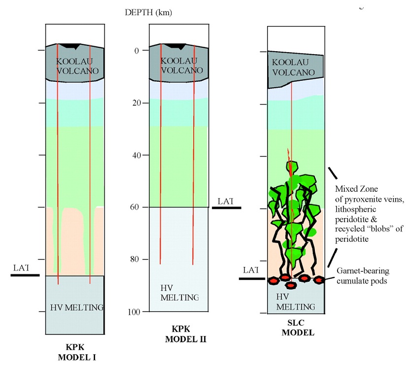
Petrologic models of the Oahu lithosphere close to the caldera area of the Koolau volcano (KPK area) and further away at SLC are shown (this study). We suggest that the lower lithosphere beneath SLC and KPK are very different. We also present two different models (Models I and II) for the sub-KPK lithosphere that are discussed in the text. LAT = Lithosphere /Asthenosphere Transition-http://ammin.geoscienceworld.org/cgi/content/full/90/5-6/871?ijkey=643e0ed80e548a5efd0b952fb5420158582dc91c |
http://www.mantleplumes.org/WebDocuments/ANDERSON_LIPS.pdf |
http://www.mantleplumes.org/WebDocuments/ANDERSON_LIPS.pdf |
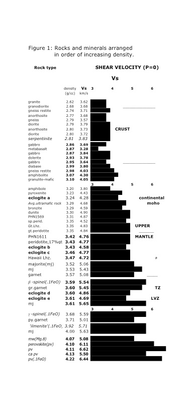
Crustal and mantle minerals and rocks arranged according to increasingdensity. Shear velocity is plotted. Eclogites have a wide variety of properties, depending on the amount of garnet, and the Fe- and Na- contents. At shallow depths eclogites havehigher seismic velocities than peridotites. At greater depth, eclogite can create a LVZ. Aseclogite warms up, by conduction of heat from the surrounding mantle, it will melt and become buoyant, creating a form of yo-yo tectonics http://www.mantleplumes.org/WebDocuments/AndersonPEPI2005.pdf |
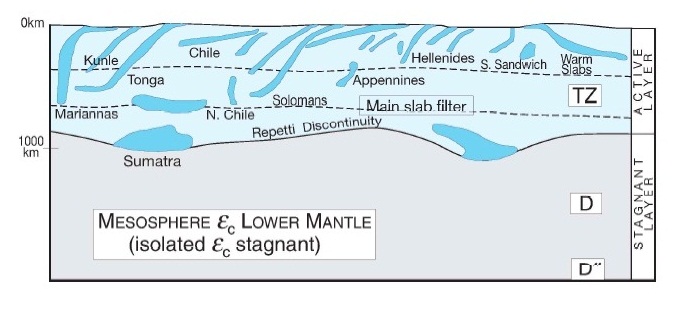
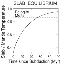
Slabs have a variety of fates in the mantle. They sink to various depths andwarm up at different rates. Some underplate continents, some have shallow dips, some are nearly vertical.-http://www.mantleplumes.org/WebDocuments/AndersonPEPI2005.pdf |
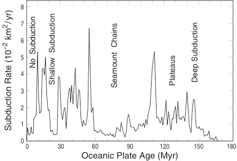
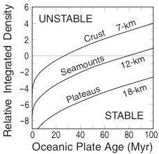
The age distribution of oceanic plates about to enter subduction zones. The younger plates will not sink deep and will thermally equilibrate rapidly. The older plates will sink deeper, and will take longer to equilibrate. (after Rowley, 2002) -http://www.mantleplumes.org/WebDocuments/AndersonPEPI2005.pdf |
Buoyancy of plates as a function of age and crustal thickness. Young plates and plates with thick crust (seamount chains, plateaus) may stay in the shallow mantle and be responsible for melting anomalies. (after Van Hunen et al.,2002) -http://www.mantleplumes.org/WebDocuments/AndersonPEPI2005.pdf |
Heating rates of subducted slabs due to conduction of heat from ambient mantle. Delaminated continental crust starts hot and will melt quickly (modified from a figure provided by Seth Stein, 2003). -http://www.mantleplumes.org/WebDocuments/AndersonPEPI2005.pdf |
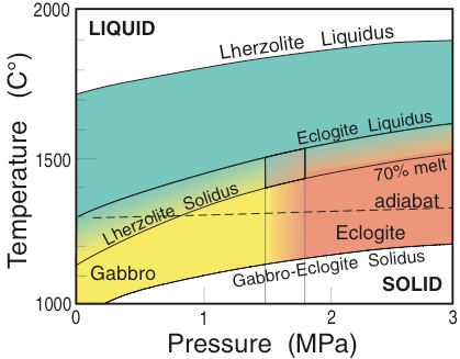
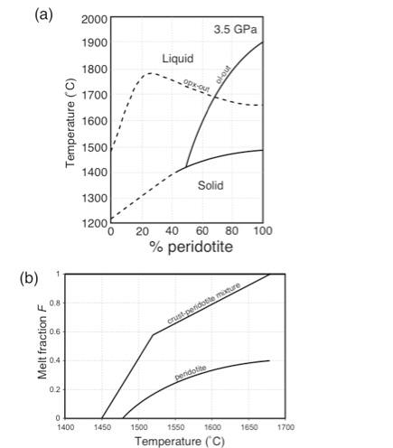
a) Solidus and liquidus for a peridotite mantle containing varying percentages of oceanic crust (adapted from Yaxley, 2000), b) Relationship between melt fraction F and temperature for fertile peridotite and a mixtureof 30% oceanic crust and 70% fertile peridotite. The higher average dF/dT and lower solidus temperature for themixture results in enhanced melt productivity at a given temperature (derived from data in Yaxley, 2000;The volume of melt is not strictly a function of mantle temperature.- http://www.mantleplumes.org/WebDocuments/LIPs_DLA.pdf |
Linear seamount chains in the Central Pacific .Map © MBARI 2004, after Davis et al, 2002.- http://www.mbari.org/volcanism/Seamounts/Seam-nonHotSpot.htm |
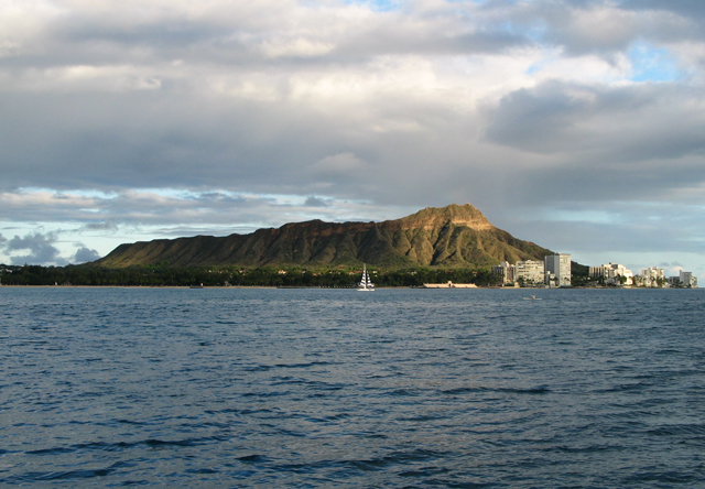
Diamond Head at sunset.Photo © J.B. Paduan, 2006 - http://www.mbari.org/volcanism/Hawaii/Default.htm |
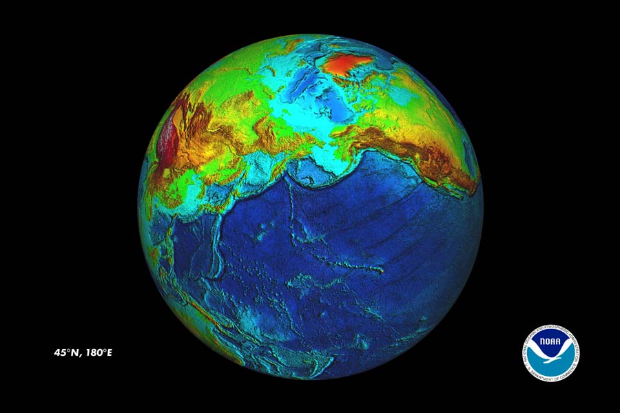
Map made at NOAA''s ETOPO2v2 Globe Viewer site-http://www.mbari.org/volcanism/Hawaii/HR-HawaiianMaps.htm |
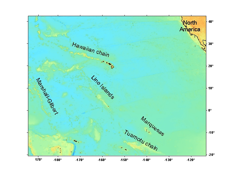
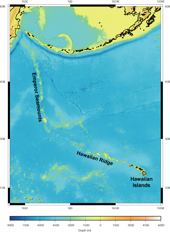
Hawaiian-Emperor Seamount chain. Map © MBARI 2004- http://www.mbari.org/volcanism/Hawaii/HR-HawaiianMaps.htm |
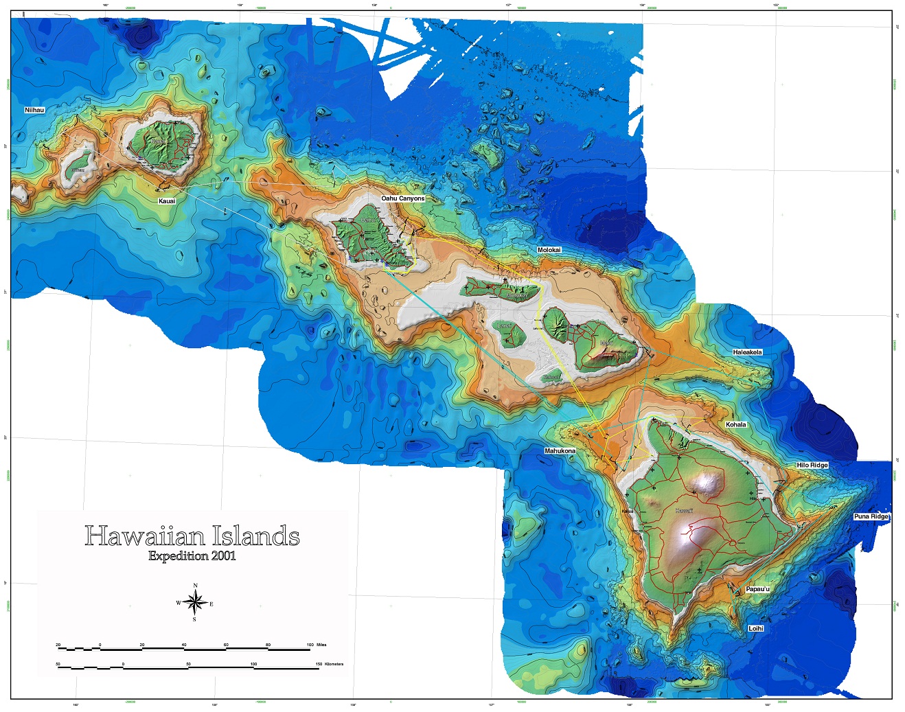
Map of the Hawaiian Islands is a combination of MBARI''s high resolution and other available bathymetric data Map © 2001 MBARI-http://www.mbari.org/volcanism/images/allDives-web.jpg |
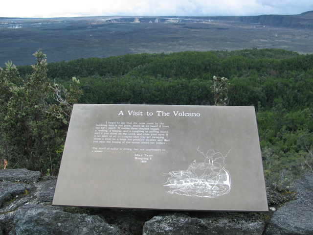
we went to Kilauea for a field trip. My favorite of Mark Twain''s quotes, on this sign overlooking Kilauea''s caldera: "The smell of sulfur was strong but not unpleasant to a sinner". -http://www.mbari.org/volcanism/Hilo06/Hilo06_blog.htm |
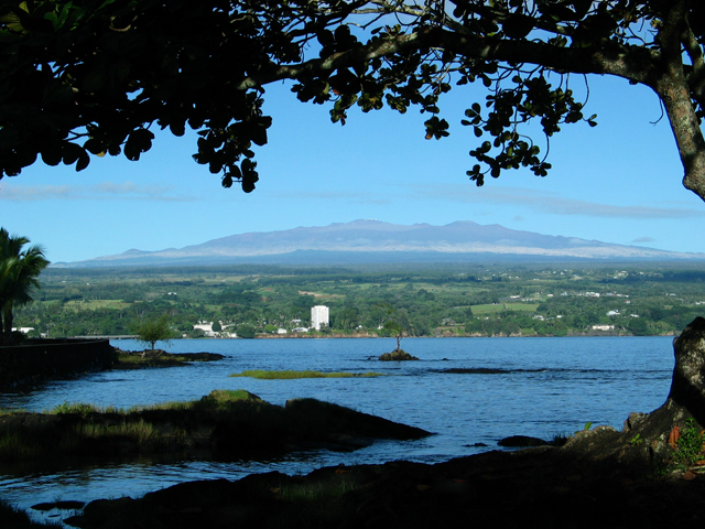
View of Mauna Kea - http://www.mbari.org/volcanism/Hilo06/Hilo06_blog.htm |
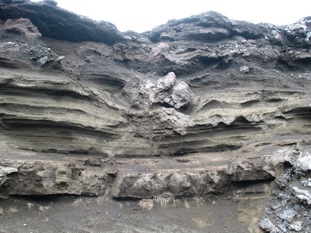
Ash from the 1790 and 1924 eruptions exposed in the southwest rift-zone of Kilauea. In the center of view, a large bomb landed in the soft ash and caused the ash layers beneath to sag- http://www.mbari.org/volcanism/Hilo06/Hilo06_blog.htm |
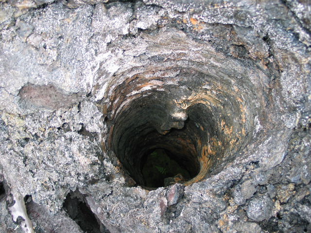
Looking down into a tree mold. Lava surrounded the tree, which chilled the lava but then burned away, leaving this hole - http://www.mbari.org/volcanism/Hilo06/Hilo06_blog.htm |
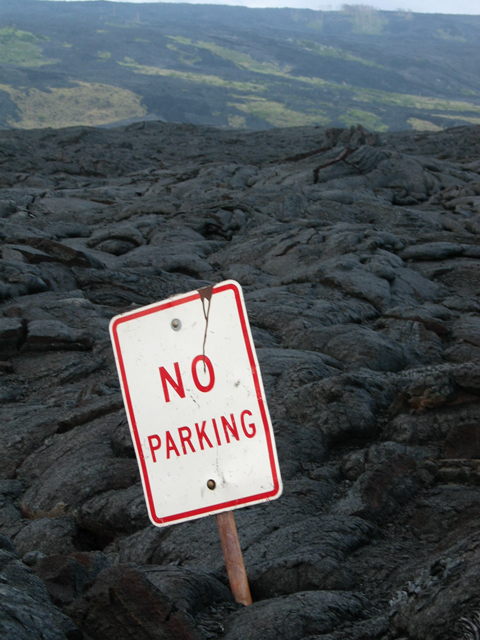
This sign was inundated by lavas of the Pu''u O''o eruption-http://www.mbari.org/volcanism/Hilo06/Hilo06_blog.htm |
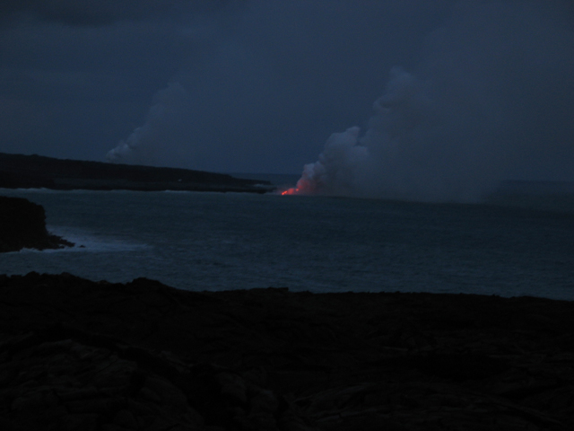
We watched lava flow into the sea after dark - http://www.mbari.org/volcanism/Hilo06/Hilo06_blog.htm |
Newport Oregon.Columnar jointing in a rosette pattern, overlain by layered sands and volcanic breccias at Yaquina Head |
large and deep lava ponds surrounded by levees, and that the ponds drained, leaving a sequence of bath-tub-ring-like lava shelves (image on left) from near the floor of the pond, all the way to the top of the levee. We also learned that the flow is not young since it has both significant sediment cover and has been lightly colonized by sessile animals. A rough guess is that it erupted perhaps 500 years ago. From our push-core and glass suction samples, we found that lava bubble fragments were common at this site, as they were at the 1998 eruption site we explored yesterday, implying that this eruption also had a mildly explosive component. All the lava samples had similar, and rather unusual mineralogy with abundant large feldspar and rarer olivine crystals, suggesting that all are from the same eruption. Apparently, this eruption began with sheet flows that extended beyond the limits of the ponds and, as the eruption rate declined, the lava did not flow as far and built up the ponds and levees. |
Artes Visuales: Encuentro de sensibilidades author Jeannette Guichard-Bunel -Francia-
сейсмотектонических блокoв
Дуги японско-яванского типа - http://plate-tectonic.narod.ru/japanandsouthphotoalbum.html
ОСТРОВ ХОККАЙДО И БЛИЗЛЕЖАЩИЕ ОСТРОВА - http://plate-tectonic.narod.ru/xokkaidomainphotoalbum.html
http://plate-tectonic.narod.ru/taivan1photoalbum.html
ОСТРОВ XOHCЮ http://plate-tectonic.narod.ru/xonsumainphotoalbum.html prover pereklu4enie
Проявления молодого вулканизма известны на о-ве Сикоку в районе г.Мацуяма. vstav v dugy
КЮСЮ – PЮKЮ http://plate-tectonic.narod.ru/kusurukumain1photoalbum.html kusu, ruku
КЮСЮ – PЮKЮ http://plate-tectonic.narod.ru/kusurukumainphotoalbum.html - main
УДЗУ-МАРИАHСКАЯ СИСТЕМА ДУГ - http://plate-tectonic.narod.ru/mariana2photoalbum.html
Источник: http://www.zoodrug.ru/topic3266.html, http://www.zoodrug.ru/topic3275.html
Вулканизм в Камчатско-Курильской островной дуге развивался различно вокруг различных литосферных глыб.На Камчатке к одним глыбам был приурочен основной магматизм с излияниями базальтовых лав, формированием щитовых вулканoв. С другими глыбами был связан преимущественно кислый магматизм. С течением времени основная магма закономерно сменялась более кислой. На Больших Курильских о-вах процессы дифференциации магмы менее выражены, но тоже обусловили распределение разных типов вулканoв вокруг литосферных глыб. Для всей дуги в целом характерна закономерная смена толеитовой магмы высокоглиноземистой и щелочной в направлении с востока на запад по мере увеличения глубины поддвига океанической литосферы под островную дугу по глубинным разломам
Напряжения сжатия приводят к поглощению и ассимиляции океанической коры, расплавлeнию в зонах Беньофа (у тихоокеанской окраины Южной и Центральной Америки) либо сминаясь и скучиваясь в виде гигантских торосов перед краем континента (у берегов Калифорнии, Британской Колумбии и частично Аляски). Там, где отмечается поглощение и расплавление океанической коры, окраина континента обрамлена глубоководным желобом, являющимся внешней границей активных континентальных окраин. Внутреннюю границу проводят по андезитовой линии — цепочке наземных вулканов, извергающих материал среднего и основного состава, в том числе андезитовые и базальтовые лавы (Сент-Хеленс в Каскадных горах, Чичон в Мексике и т. д.).
На тихоокеанской окраине Северной Америки (Калифорния, Орегон и Вашингтон) «борьба» между древней, Тихоокеанской и молодой, Северо-Американской плитами зашла настолько далеко, что под континент ушел северный сегмент Восточно-Тихоокеанского поднятия. После того как это случилось, тихоокеанская окраина Северной Америки стала действовать как бульдозер. Огромный «торос» из фрагментов океанической коры и осадочных масс, составлявших ее чехол, громоздится в настоящее время у берегов Калифорнии, наращивая ее в сторону океана. Это поднятие, получившее название аккреционного хребта, состоит из приподнятых гряд и разделяющих их впадин. Во впадинах осадки залегают спокойно, тогда как в грядах они собраны в складки. Последние частично срезаны волновой эрозией и составляют шельф и склон Калифорнии. Частично же они выведены на поверхность и слагают Береговые хребты. Y такой окраины пoннжeна вулканическая деятельность, но сохраняется состояние сейсмической опасности. Здесь нет в строгом смысле ни континентального склона, ни глубоководного желоба. Первый замещен системой подводных поднятий и прогибов. Глубина их залегания относительно уровня океана постепенно и неравномерно возрастает по мере удаления от побережья. Желоб отсутствует, зона Беньофа не выражена. Данный тип окраины, получившей название трансформнoй (невадийской).
http://srs.myrusakov.ru/html/?utm_source=YandexDirect&utm_medium=cpc&utm_campaign=FreeSRS-YandexDirect-107683031 kak zarabotat
http://www.seapeace.ru/oceanology/continents/689.html hot spots
Аксиоматические основы ландшафтной экологии - http://www.seapeace.ru/oceanology/ecology/770.html
Do text http://dept.astro.lsa.umich.edu/~cowley/GCandMoon.html - Simple lunar strategraphy
sdel v kur Камчатская дуга представляет собой молодой ороген с мощной трехслойной земной корой. Она развивалась с середины мела (100 MA). Молодой вулканизм претерпел сложное трехцикличное развитие с конца олигоцена (25 млн. лет). Для третьего, плейстоцен-современного, цикла характерна смена базальтового вулканизма в Срединном хр. на кислый в Срединнокамчатском рифте и особенно в Восточной и Южной Камчатке.
Sdel v kur Курильская дуга—молодая, но более зрелая, нежели Алеутская. Она заложилась на океанической земной коре в конце мела (70 MA) . "Гранитный" слой в разрезе земной коры образует небольшие линзы в островных глыбах на северном и южном флангах дуги и отсутствует в ее средней части. Вулканизм претерпел на Курилах многоцикличное развитие. Для среднеплейстоценово-современного этапа его развития характерна андезито-базальтовая и андезитовая магма и относительно небольшая ее дифференциация. Последняя происходила преимущественно на флангах дуги, там, где сформировались линзы "гранитного" слоя в земной коре.
В зоне Восточно-Тихоокеанского подводного хребта (21о с.ш.) и во впадине Гуаймас (Калифорнийский залив) на дне фонтанируют гидротермы с температурой 315–350oC и концентрацией растворенного сероводорода 223–284 мг/л. Содержание рудных металлов в растворе на несколько порядков выше, чем в океанской воде, и достигает (мкг/кг): кобальта – 13.4, меди –2790, цинка– 6930, свинца – 135, кадмия – 20, серебра – 24. Из этого следует, что наличие сероводорода не препятствует высокой миграционной способности металлов в кислом горячем растворе.
http://plate-tectonic.narod.ru/volcanooceanphotoalbum.html Океанический вулканизм
Transf Кларион-Клиппертон - http://plate-tectonic.narod.ru/clarionclippertonphotoalbum.html
http://kurilskiy.ru/?main,default,id=287 kurilski zapovednik
http://ref.repetiruem.ru/referat/ekaterina-ii-i-ee-blizhajjshee-okruzhenie
-----
http://en.wikipedia.org/wiki/Clipperton_Island + transform
http://en.wikipedia.org/wiki/Clipperton_Island + transform
Sdelano ( See pictire biotect), mantia –core mag pole dynamo http://plate-tectonic.narod.ru/fanerozoiphotoalbum.html биозоны и геомагнитныe инверсии в фанерозое
http://plate-tectonic.narod.ru/paramushirphotoalbum.html
http://plate-tectonic.narod.ru/paramu6irphotoalbum.html
http://plate-tectonic.narod.ru/kuronecotanphotoalbum.html
http://plate-tectonic.narod.ru/kurmatuaphotoalbum.html
http://plate-tectonic.narod.ru/kuruurupglibaphotoalbum.html
http://plate-tectonic.narod.ru/kuriturupglibaphotoalbum.html
http://plate-tectonic.narod.ru/kurkuna6irglibaphotoalbum.html
http://plate-tectonic.narod.ru/kurillinks.html KUR LINKS
http://plate-tectonic.narod.ru/oxotsk1links.html
Saxpuga4photoalbum virus take pictures in LACC – origin grazev
http://angelinos.narod.ru/saxalin2photoalbum.html -Авария на нефтяной платформе.
Kasp Пассивная окраина рифейского океана на юго-востоке Восточно-Европейской плиты http://plate-tectonic.narod.ru/kaspiiphotoalbum.html
Проявления флюидодинамики недр в Каспийском море http://plate-tectonic.narod.ru/kaspii1photoalbum.html
парникового эффекта CH4 В настоящее время серьезную озабоченность вызывают возможные последствия парникового эффекта, влияние которого на планету постоянно возрастает. Основная роль в этом процессе отводится атмосферным парниковым газам. Поскольку метан является неотъемлемым компонентом атмосферы, он влияет на климат. Несмотря на то, что его атмосферная концентрация в 200 раз меньше чем углекислого газа, вклад метана в "парниковый эффект" оценивается примерно в 25–30 % от вклада СО2.
Ecol Mетан в воде и донных осадках реки Амур http://plate-tectonic.narod.ru/CH4photoalbum.html
Vstup Согласно концепции вторичности океанических впадин Г. Штилле, океаны делятся на две группы - древние и молодые. К древним океанам относится Тихий, к молодым - все остальные. Эта концепция разделяется рядом зарубежных и советских исследователей (М. В. Муратовым, Ю. М. Пущаровским и др.). Ее сторонники обращают внимание на то, что впадины Атлантического, Индийского и Северного Ледовитого океанов не имеют видимой генетической связи с окаймляющими их побережьями. Они как бы наложены на совершенно разные по возрасту и происхождению структурные элементы материков. Восточный берег Атлантического океана срезает каледонские складчатые структуры Норвегии, Англии и Ирландии, герцинские структуры Западной Франции, альпийскую область Испании, палеозойский складчатый пояс Северной Африки и т. д. Такая же картина наблюдается на западной окраине океана и вдоль побережий Индийского и Северного Ледовитого океанов.
В отличие от остальных океанов Тихий океан окружен концентрически расположенными складчатыми поясами разного возраста, начиная от позднего протерозоя. Более древние структуры срезаются тихоокеанским складчатым кольцом. Возраст складчатых поясов, обрамляющих Тихий океан, закономерно меняется (в сторону океана) от древнего к более молодому вплоть до современного. можно прийти к заключению о большой древности Тихого океана. Г. Штилле также противопоставлял молодым вторичным океанам древнюю впадину Тихого океана, которая, по его представлениям, возникла в глубине докембрия.
Современная тихоокеанская переходная зона с многочисленными морями, системами островных дуг и глубоководных желобов характеризуeтся активным тектоно-магматическим режимом.