 | Death Valley, B&R and desert |
|
Panamint Range Death Valley |
Amargosa Valley, California |
Mono Lake, California. the white towers are tufa, calcium carbonate, precipitated when the water |
|
Aerial view of part of Death Valley salt pan, CA.Dry lakebeds that may or may not become temporarily flooded by water. |
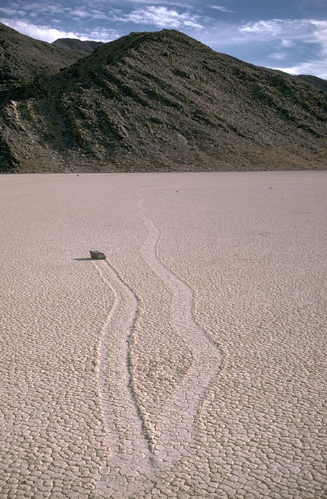
Sliding rock on Racetrack Playa, SE California |
View of Death Valley salt pan from near Dantes View. The white material on the valley floor is salt. Note thealluvial fans; they tend to be small and well-defined on the east side but coalesce into a large bajada on the west side.The generally accepted explanation for this asymmetry is that the valley floor is tilted gently eastward because of the faulting, which causes material on the downdropped east side to become trapped |
|
Partially flooded Death Valley salt pan. Note the crystallizing salt in the foreground. View is looking north from Badwater |
Crystalline salt and polygonal fractures on Death Valley salt pan. View towards the south |
DV |
|
Playa at sunrise. Alvord Desert playa, SE Oregon |
Playa at sunrise: Alvord Desert and Steens Mountain, SE Oregon. Steens Mtn rises to an elevation of over 9000 along a recently active normal fault zone |
Playa and Parallel mountain ranges, eastern Nevada. Numerous dry lake beds, or playas, occupy the basins of the Basin and Range Province; they used to be substantial lakes during the wetter climates of the Pleistocene. They are typically very light colored, as they consist of fine-grained clastic material along with salts, deposited during evaporation. A playa occupies the foreground of this photo. Behind it are a series of tilted fault-block ranges. Note the playa in the background |
|
Deep Springs Lake and playa. Deep Springs Valley, SE California |
Evaporating playa lake, leaving a deposit of salts, eastern Washington |
Racetrack Playa, SE California |
|
Papoose flat |
Fault scarp in Owens Valley fault zone, Lone Pine, California. This fault scarp is the product of at least three earthquakes,the most recent being the 1872 Owens Valley earthquake. Through time, slip on the fault has been responsible foruplift of the Sierra Nevada Range |
Aerial view of Black Mtns. fault zone, DeathValley, California. The abrupt change from valley floor to mountain, lack of embayment of the mountain front, and the wineglass canyon, all point to recent activity on this fault zone |
|
Fault scarp cutting alluvial fan, Death Valley, CA. This fault offsets the Hanaupah alluvial fan in Death Valley by more than 10 meters, the result of numerous slip events. Given that it cuts alluvial fan sediments, the fault must be relatively young. Interestingly, it lies on the west side of the valley, whereas most of the active faults lie on the east side |
Disconformity, Death Valley, California. Disconformities are unconformities in which the younger material is roughly parallel to the contact--and thus appears to be concordant. This photograph shows the rocks being parallel on the left side. However, on the right it shows the gravel cutting down into the marble to indicate erosion. Photo is approximately 1 meter acros |
Brittle Features - Aerial view of the Basin and Range Province, eastern Nevada. The Basin and Range Province is so named because its physiography consists of alternating basins and ranges. This topography is a product of crustal extension |
|
Brittle structures -Normal faults. At entrance to Mosaic Canyon, Death Valley, California.Note that there are two opposing faults in this image; the largest being the one immediately right of the person |
Brittle features -. Conjugate normal faults, Black Mountains frontal fault zone, Death Valley, California. Note that the rock these faults cut is itself brecciated, to suggest a complicated history of deformation |
Aerial view of the Idaho-Wyoming Fold-Thrust Belt |
|
Aerial view of the Keystone Thrust fault, southern Nevada. View towards the north. The Keystone thrust is the leading edge of the Sevier Fold-Thrust Belt in this region. It places the Cambrian Bonanza King Limestone (gray) over the Jurassic Aztec Sandstone (tan). The Aztec Sandstone is equivalent to the Navajo Sandstone, which is exposed so beautifully in Zion National Park. |
Small thrust fault and fold in sandstone, southern Oregon |
Aerial view of right-lateral strike-slip fault, southern Nevada |
|
Vertical joints in granitic rock, Alabama Hills, southeastern California |
Ductile features: Mylonitic gneiss and asymmetric porphyroclasts. This sample, from the Badwater Turtleback in Death Valley, California, shows top-to-the-right (northwest) shear strain, as determined fromthe shape of the felsic porphyroclasts |
Outcrop of slate. Pioneer Mountains, Idaho |
|
Contact Metamorphism. The white band is a talc deposit in southern Death Valley, California. Thed ark green rocks below the talc is diabase; the brown rocks above the talc is dolomite. The talc formed by contact metamorphism of the dolomite by the intruding diabase. Note the mine workings along the deposit |
Alluvial fan at Badwater, Death Valley, CA. Note the fault-bounded nature of the mountain front and the recently formed fault scarps on either side of the canyon mouth |
Alluvial fan in southern Death Valley, CA. |
|
Bajadas are coalesced alluvial fans. This bajada lies on west side of Death Valley, CA |
Bajada on west side of southern Snake Range, Nevada. This photo depicts much of Great Basin National Park. Wheeler Peak, the second highest peak in Nevada is the high peak on the ridge, just left (north) of the center of the image |
Granitic boulders on alluvial fan. Death Valley National Park, California |
Source: http://www.marlimillerphoto.com/images.html


