 | Methane deposits |
|
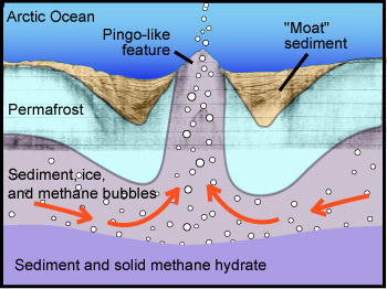
This conceptual drawing (not to scale) shows Paull''s hypothesis that methane gas from deep hydrate deposits could push sediment up from below the ocean bottom to create a pingo-like feature. The gray lines in the background are from a seismic profile through one of these enigmatic features. |
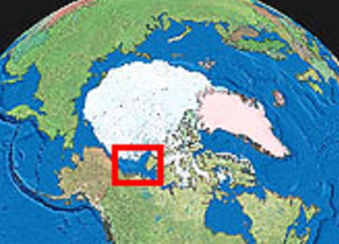
This study took place in the Beaufort Sea, far above the Arctic Circle, off the north coast of Canada. For a closer view of the study area (outlined in red) |
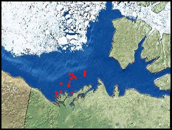
The red dots on this map show a few of the hundreds of undersea hills ("pingo-like features") in the Beaufort Sea. Many terrestrial pingos are located on the Tuktoyaktuk Peninsula, just below the red dots. |
|
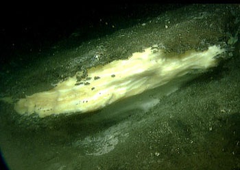
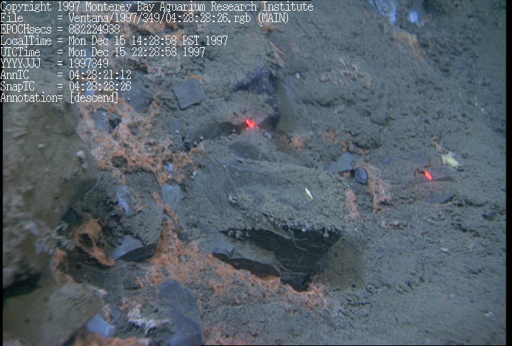
Although methane hydrates are not stable at the seafloor in the area of this study, they do appear on the seafloor in some deeper areas. These hydrates are exposed on the seafloor off the coast of British Columbia. Pure methane hydrates are white, but these contain hydrocarbons that give them a yellowish or brownish cast. |
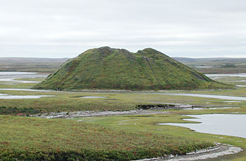
This photograph shows a terrestrial pingo rising on the Tuktoyaktuk Peninsula, in far northern Canada. "Pingo-like features" are similar in shape, but form on the floor of the Arctic Ocean |
Bacterial mat (orange) fueled by chemical-rich fluids seeping -http://www.mbari.org/volcanism/Margin/Marg-Hydrates.htm |
from http://www.mbari.org/news/news_releases/2007/paull-plfs.html
Methane bubbling through seafloor creates undersea hills
According to a recent paper published by MBARI geologists and their colleagues, methane gas bubbling through seafloor sediments has created hundreds of low hills on the floor of the Arctic Ocean. These enigmatic features, which can grow up to 40 meters (130 feet) tall and several hundred meters across, have puzzled scientists ever since they were first discovered in the 1940s.
Writing in the January issue of Geophysical Research Letters, MBARI geologists Charlie Paull and William Ussler and their coauthors described the results of field work they conducted on the Beaufort Sea Shelf, offshore of the north coast of Canada. In this area of year-round sea ice and permafrost, the team spent over a month mapping the seafloor and collecting sediment cores and gas samples from these underwater hills, which they call "pingo-like features
"Pingos," small, dome-shaped, ice-cored hills, are found in many Arctic regions. "Pingo-like features" are similar in shape and size to pingos on land, but are found underwater, on the continental shelf in several parts of the Arctic. Previous studies have suggested that pingo-like features are pingos that formed on land but were submerged when sea level rose following the end of the last ice age, over 10,000 years ago.
Based on their geologic fieldwork and subsequent chemical analysis of the gas and sediments from eight pingo-like features, Paull and his coauthors propose an alternative hypothesis: Pingo-like features form when methane hydrate (a frozen mixture of gas and seawater) decomposes beneath the seafloor, releasing gas that squeezes deep sediments up onto the seafloor like toothpaste from a tube.
The geologists based this hypothesis on a number of observations and measurements. First, sound waves bounced through the pingo-like features showed that they were not built up from layers, but consist of a jumbled mixture of sediment and small nodules of fresh-water (rather than salt-water) ice. Carbon-14 dating of organic matter in the sediment at the crests of several hills showed that this sediment was deposited before the last ice age, thousands of years before sediments on the surrounding seafloor. Finally, many of the pingo-like features were surrounded by shallow "moats," where the seafloor within a kilometer of the hill had apparently subsided.
Even with evidence that pingo-like features were made of older, deeper sediment that had been pushed up from beneath the seafloor, the geologists still had to figure out what geologic process could generate enough pressure to lift seafloor sediments. The most obvious source of such pressure was methane gas, which the researchers observed bubbling out of the tops of several pingo-like features
After chemically analyzing this gas, the researchers concluded that it originated as methane hydrate, an ice-like mixture of water and methane that forms within sediments under much of the Arctic seafloor and beneath permafrost areas on land. Methane hydrate can only remain solid at low temperatures and high pressures. Such conditions exist several hundred meters below the seafloor in this part of the Arctic Ocean.
The researchers suggested that such buried hydrates might be decomposing and releasing large amounts of methane gas. This seemed possible because the seafloor in this area has been gradually warming over the last 10,000 years, after being flooded as sea levels rose at the end of the last ice age. Although within a few degrees of freezing, the seawater in this region is at least 10 degrees Centigrade (20 degrees Fahrenheit) warmer than permafrost-filled soil. Thus, when the ice sheets from the last ice age melted and the ocean flooded the continental shelves, it caused the seafloor sediment to become warmer.
Over thousands of years, the scientists believe, this "wave" of warming moved downward through the sediment. Eventually it reached the frozen methane hydrates, hundreds of meters down. Even a slight temperature increase could have caused some of the buried methane hydrates to decompose, releasing methane into the surrounding sediments
Paull and Ussler''s data suggest that this newly released methane migrated sideways under the seafloor, held in place by an impermeable layer of frozen soil that lies between the hydrates and the seafloor. Eventually it collected and moved toward the surface along faults or in other areas where the sediments were relatively weak.
Eventually the extruded sediment collected to form the low undersea hills visible on bathymetric charts. At the same time, areas on either side of the mounds, where much of the gas and sediment originated, slowly collapsed, forming the deeper "moats" observed by the researchers.
According to Paull, "We don''t know if this gas and sediment was burped up in a single year, or moved slowly like a glacier." In either case, Paull''s data suggest that pingo-like features are growing in response to warming that started thousands of years ago. Thus, their growth is not a result of human-induced global warming. However, Paull''s research does show that pingo-like features are still growing and releasing methane today.
Because methane is a potent greenhouse gas, climate scientists would like to know how much is bubbling up from the seafloor worldwide. Future research on methane hydrates and pingo-like features may help address this question. As Paull phrased it, "Pingo-like features are one of the places where we see methane coming up through the seafloor. As yet we don''t know how important they are, since we don''t know how much gas is coming up in the Arctic as a whole or in other seafloor areas."
This study also provides scientists with clues to how buried methane hydrate deposits might behave in other parts of the world in response to global warming. According to Paull, "One of the questions we''re trying to answer is ''What do buried hydrates do when they are suddenly warmed up?'' In this case, we have a field experiment that''s been going on for thousands of years."
from MBARI -http://www.mbari.org/news/news_releases/2003/paull_pingos.html
He climbed slowly up the side of the pingo. Reaching the top, he paused at the edge of a small pond and gazed out at the barren coastal plain, where a thin coat of moss and tundra barely hid the solid permafrost beneath. The pingo on which he stood was the highest point around, except, off in the distance, the low rounded silhouette of another pingo. He had read that over a thousand of them dotted this remote peninsula. His gaze shifted to the small pond at his feet. Looking closely, he discovered small bubbles rising through the water. He smiled.
He thought about permafrost and ice and the current theory of how pingos form. In most parts of the Arctic, permafrost (a layer of permanently frozen soil) extends hundreds of meters below the earth''s surface. However, beneath Arctic lakes, the permafrost melts, leaving a region of water-saturated soil. According to theory, a pingo is created when one of these lakes dries up, allowing permafrost to reform at the ground surface, trapping water underneath. As the surface permafrost thickens, it puts pressure on the subsurface water, which creates a bulge in the overlying permafrosta pingo.
Paull had his doubts about the standard theory, which focused on the fact that pingosor at least "pingo-like-features"were known to exist on the sea bottom (where lakes are rather rare). Some researchers contended that these submarine pingos had formed on land during periods of lower sea level. However, Paull thought this unlikely because waves and ice would have quickly eroded and destroyed the pingos as the ocean rose around them.
Paull suspected that the submarine pingos had formed beneath the sea, and that they might still be forming. This was why he had come to the Arctic. About five years before, he and fellow geologist Bill Ussler had written a National Science Foundation (NSF) grant proposal to investigate methane hydrates in sea-bottom sediments and their relationship to submarine pingos. The NSF had turned down his proposal with the comment that submarine hydrate research was not a research topic they were interested in funding.
Within the next few years, however, funding agencies became vitally interested in Arctic processes, global warming, and gas in sea-bottom sediments. Scientists learned that huge volumes of methane were locked up in oceanic sediments, mixed with frozen water to form methane hydrates. Some even suggested that these hydrates could have triggered extreme shifts in the Earth''s climate by suddenly releasing vast amounts of methane (a greenhouse gas) into the atmosphere.
With undersea methane becoming a hot topic, Paull and Ussler decided to resubmit their proposal. As Paull put it, they simply asked the question, "Why don''t we go and see what it takes to get gas released from methane hydrates today?" They pointed out that the Arctic Ocean was a logical place to look for such releases because hydrates in this area had been slowly warming since the end of the last ice age, more than 10,000 years ago.
They also suggested that, rather than searching the entire Arctic ocean for dissolved gas, scientists should look for geological features that might indicate where gas was emerging from the sediment. Submarine pingos were one such feature. Similarly, gas might also be found around submarine pockmark fields, where the sea bottom is scarred by hundreds of meter-deep pits in the sea floor.
This time, their proposal was enthusiastically accepted. This was why Charlie Paull was standing on a low hill, watching bubbles emerge from a shallow pond, and smiling.
Several days later, he set out in the Canadian Coast Guard vessel Nahidik, with a goal of obtaining cross-sections through several submarine pingos using seismic profilingbouncing sound waves off sediment layers in the sea bed. But these efforts were thwarted by the vagaries of drifting ice and the very real risk of marauding polar bears climbing on board the low-sided survey vessel. Thus, Paull had to rely on decade-old surveys as he began the second part of his research, which focused on obtaining sediment cores in and around submarine pingos.
However, before he could begin his second cruise, aboard the Canadian icebreaker Sir Wilfred Laurier, the challenges of the Arctic became apparent once again. Thick fog prevented him from flying to meet the icebreaker in time for its departure. After four days of what he called "a mild form of purgatory," the icebreaker came to him, or at least within 200 miles of where he was stranded, so that the ship''s helicopter could pick him up.
On board the icebreaker, Paull met Ussler, fellow MBARI researchers Rendy Keaten and Richard Whitmarsh, and scientists from Canada and the United States Geological Survey. Although the MBARI scientists were all new to Arctic research, the Canadians were old hands who, according to Paull, had "hung out together in the Beaufort Sea for years."
They spent the next three weeks dodging pack ice and shallow water while collecting about eighty sediment cores in and around half a dozen submarine pingos and two pockmark fields. This was their primary missionto take samples of mud and ice and to analyze the water and gas within these samples. Specifically, they wanted to find out if gas was trapped in the sediment, and if so, determine what kind of gas it was and where it was coming from.
To their surprise and delight, the researchers found plenty of gas in cores from the submarine pingos. They also used a small remotely operated vehicle (ROV) to record video of gas bubbling out of the tops of two submarine pingos. Encouraged by this finding, Ussler decided to try and obtain a sample of this gas. Improvising with some decidedly low-tech tools, including an old funnel and a large plastic syringe, he succeeded in converting the small ROV into a submarine gas-collection system. He also used a small boat, a plastic bucket, and his bare hands to collect gas bubbling to the sea surfaceno mean feat in frigid Arctic water.
Early results from the geochemical analyses are intriguing. For example, the gas emerging from the submarine pingos appears to be nearly pure methane. This suggests that it did not originate from a natural gas reservoir that lies deep below the sea floor in this area. In addition, water in the submarine pingo cores is only half as salty as water in the surrounding sediments, suggesting that it came from buried freshwater ice rather than from the overlying seawater.
Paull is quick to point out that none of these early data conclusively proves that the gas and fresh water in the pingos originated in methane hydrates. However, the circumstantial evidence is very suggestive. His team is currently analyzing oxygen isotopes in water from the cores, which will be compared with oxygen isotope ratios in local seawater and groundwater.
With his data still coming in and numerous cores to analyze, Paull and his coworkers are not yet ready to advance their own theory of how pingos form. But they are convinced that pingos and pockmarks are active features that relate to gasses and/or liquids flowing up from the subsurface.
With any luck, their research will supply another piece in the scientific puzzle of past and present climate change. Not only that, Paull''s team will be able to provide a new perspective on a geologic feature that has baffled geologists for generations. Not a bad result for a month''s workand half a decade of preparation. Several months after his trip to the Arctic, Charlie Paull is still smiling...
GAS HYDRATES AND COLD SEEPS
Gas hydrate deposit detection and instability
Chemosynthetic biological communities are evidence of the presence of reduced, chemical-rich fluids at the seafloor. When the fluids are generated at ambient temperatures, as opposed to high temperatures such as at hydrothermal vents, they are said to be "cold seeps". Cold seeps have now been found in diverse locations, such as on canyon walls, on active continental margins, from limestone escarpments, and above hydrocarbon deposits.
Acoustic surveys also provide evidence of cold seeps, and of layers of gas hydrates (carbon-dioxide, methane, and other hydrocarbon gases frozen into an icy slush at high pressure and low temperature) within the sedimentary pile. Gas hydrates are large reservoirs of methane, which is a fossil fuel and green-house gas. Methane is also the compound required by methane oxidizing microbes whose by-product feeds the hydrogen-sulfide oxidizing microbial symbionts that feed the cold-seep biota. Inst