 | Cenozoic geological and plate tectonic evolution of SE Asia and the SW Pacific |
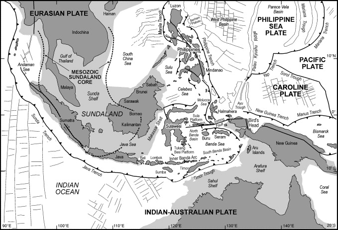
Principal geographical features of the region covered in the SE Asia reconstructions. The light shaded areas are the continental shelves of Eurasia and Australia drawn at the 200 m isobath |
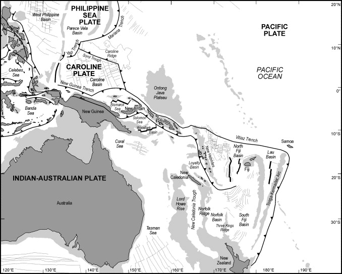
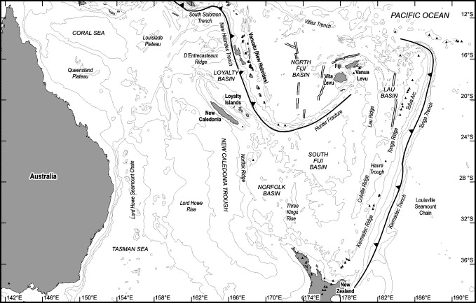
Principal geographical features of the region covered in the SW Pacific reconstructions. The light shaded areas are the continental shelves of Eurasia and Australia drawn at the 200 m isobath |
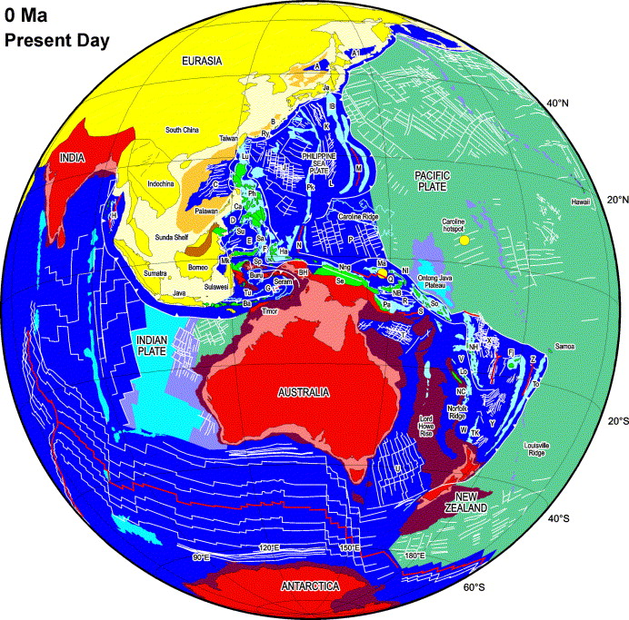
Present-day tectonic features of SE Asia and the SW Pacific as shown on the global reconstructions. The colours used in the reconstruction animations and figures on the CD are summarised below. White lines in ocean basins are selected marine magnetic anomalies. Cyan lines outline bathymetric features. Red lines are active spreading centres. White lines with triangles are subduction zones and other white lines are strike-slip faults. The present extent of the Pacific Plate is shown in turquoise. Areas filled with green are mainly arc, ophiolitic, and accreted material formed at plate margins during the Cenozoic. Areas filled in cyan and pale mauve are submarine arc regions, hot spot volcanic products, and oceanic plateaux. Pale yellow areas represent submarine parts of the Eurasian continental margins. Deep yellow is used for deeper marine areas of South China Sea, Okinawa Trough and Japan Sea underlain by stretched continental crust. Pale and deep pink areas represent submarine parts of the Australian continental margins. To the west of Australia Jurassic ocean crust is shaded turquoise and Cretaceous ocean crust is shown in two shades of blue. Letters represent marginal basins and tectonic features as follows. Marginal basins: A1, Kuril Sea; A, Japan Sea; B, Okinawa Trough; C, South China Sea; D, Sulu Sea Ca; E, Celebes Sea; F, Molucca Sea; G, Banda Sea; H, Andaman Sea; J, West Philippine Basin; K, Shikoku Basin; L, Parece Vela Basin; M, Mariana Trough; N, Ayu Trough; P, Caroline Sea; Q, Bismarck Sea; R, Solomon Sea; S, Woodlark Basin; T, Coral Sea; U, Tasman Sea; V, Loyalty Basin; W, Norfolk Basin; X, North Fiji Basin; Y, South Fiji Basin; Z, Lau Basin; Tectonic features: Ba, Banda Arc; BH, Bird''s Head; Cagayan Arc; Fj, Fiji; Ha, Halmahera Arc; IB, IzuľBonin Arc; Ja, Japan Arc; Lo, Loyalty Islands; Lu, Luzon Arc; Mk, Makassar Strait; Mn, Manus Island; NB, New Britain Arc; NC, New Caledonia; NH, New Hebrides Arc; NI, New Ireland; Nng, North New Guinea Terranes; Pa, Papuan Ophiolite; Pk PalauľKyushu Ridge; Ry, Ryukyu Arc; Sa, Sangihe Arc; Se, Sepik Arc; So, Solomons Arc; Sp, Sula Platform; Su, Sulu Arc; TK, Three Kings Rise; To, Tonga Arc; Tu, Tukang Besi Platform. |
Principal fragments used in the plate reconstructions for Asia and SE Asia |
Principal fragments used in the plate reconstructions for northern and eastern Australia and the SW Pacific |
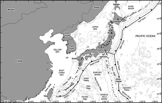
Geographical features of northeast Asia. In this and other figures small black filled triangles are volcanoes from the Smithsonian database (http://www.nmnh.si.edu/gvp/), and bathymetry is from the GEBCO digital atlas (IOC, IHO, BODC, 1997). Bathymetric contours are at 200, 2000, 4000 m and 6000 m |
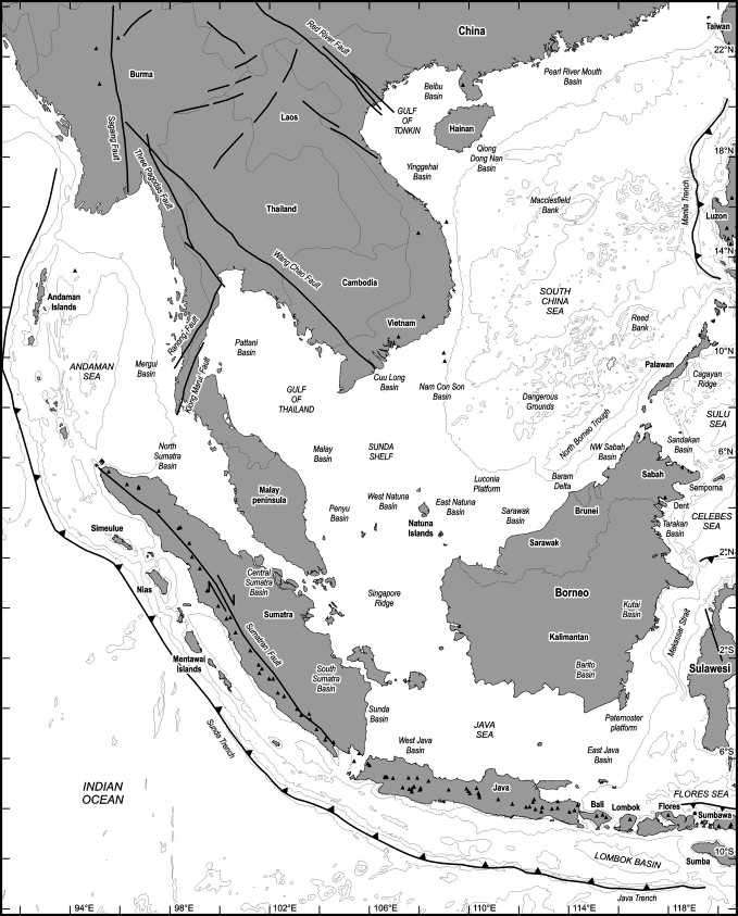
Geographical features of Indochina and Sundaland. Small black filled triangles are volcanoes from the Smithsonian database. Bathymetric contours are at 200, 2000, 4000 and 6000 m. |
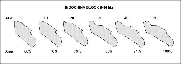
Changing shape of the Indochina region in the reconstructions modelled by allowing the east and west sides of the area to move with different rotation parameters, and allowing overlap with adjacent Asian blocks. The region is that of present-day land east of the Sagaing Fault and south of the Red River Fault and is approximately the area in which there are no major Cenozoic sedimentary basins, all of which are in the present-day offshore areas. The reconstructions simulate a deforming block. The figures by each outline of different age represent the area of the block in terms of the area at 50 Ma. If it is assumed that block volume remains constant this implies crustal thickening, although changing elevation may have been modified by erosion. |
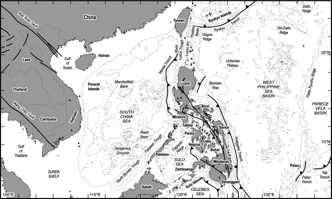
Geographical features of the Philippines and surrounding regions. Small black filled triangles are volcanoes from the Smithsonian database. Bathymetric contours are at 200, 2000, 4000 and 6000 m |
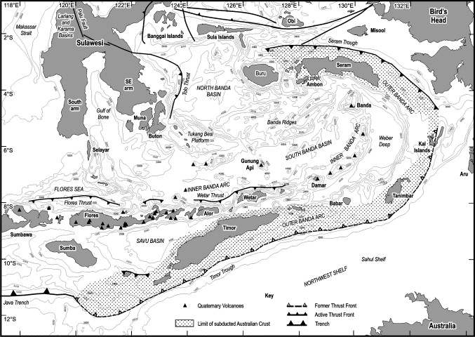
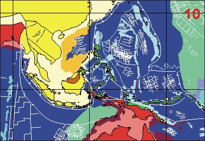
Geographical features of the Banda Sea and surrounding regions. Small black filled triangles are volcanoes from the Smithsonian database. Bathymetric contours are at 1000, 2000, 3000, 4000 and 5000 m. |
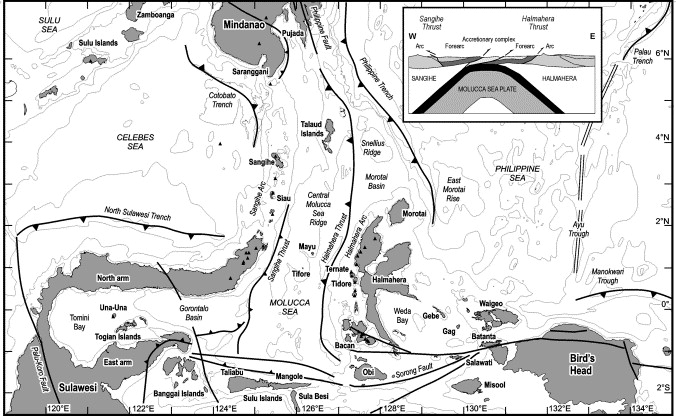
Geographical features of the Molucca Sea and surrounding regions. Small black filled triangles are volcanoes from the Smithsonian database. Bathymetric contours at 200, 2000, 4000, 5000 and 6000 m are from the GEBCO digital atlas (IOC, IHO, BODC, 1997) and MODEC cruise data (Rangin et al., 1996). Large barbed lines are subduction zones and small barbed lines are thrusts. Note that the direction of surface thrusting in the Molucca Sea is correctly shown. Thrusts on each side of the Molucca Sea are directed outwards towards the adjacent arcs, although the subducting Molucca Sea Plate dips east beneath Halmahera and west below the Sangihe arc (, and ). The Halmahera Thrust can be traced south from the Philippines ( and ) and is interpreted as the base of the Sangihe forearc now over-riding the Halmahera Arc, whereas the Sangihe Thrust cannot be traced north of Siau and is not present in the northern part of the Sangihe forearc. It is interpreted as a backthrust within the accretionary prism (Hall, 2000), as shown in the inset figure |
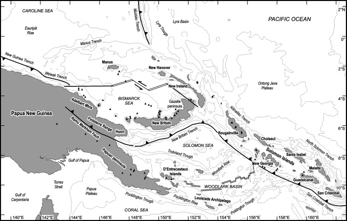
Geographical features of the Bismarck Sea and Woodlark Basin and surrounding regions. Small black filled triangles are volcanoes from the Smithsonian database. Bathymetric contours at 200, 2000, 4000 and 6000 m. |
Geographical features of the Southwest Pacific region including the Solomons, the New Hebrides and surrounding regions. Small black filled triangles are volcanoes from the Smithsonian database. Bathymetric contours are at 200, 2000, 4000 and 6000 m |
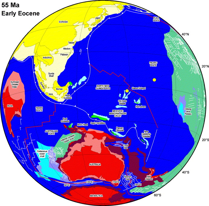
Reconstruction at 55 Ma. This preceded the major collision between India and Asia. The possible extent of Greater India and the Eurasian margin north of India are shown schematically. Ophiolites representing the forearcs of intra-oceanic island arcs were emplaced on the north Australian continental margin from about this time, although emplacement is generally poorly dated. A spreading centre between the Pacific and North New Guinea Plates is inferred for reasons discussed in the text. In the north Pacific there was a spreading centre between the Pacific and the Kula plates. The reconstruction at this stage is not kinematically consistent in the Pacific because of the limited evidence available. There must have been several microplates between the Australian and Pacific plates, as today, most of which were subsequently eliminated by subduction.Reconstruction at 50 Ma. IndiaľAsia collision began. Extension was underway within Sundaland, in east Borneo, the east Java Sea, and Sumatra. Subduction was initiated at the present east margin of the Philippine Sea Plate, accompanied by voluminous boninite magmatism causing rapid growth of the IzuľBoninľMariana Arc. As for 55 Ma this reconstruction is not kinematically consistent in the Pacific region. However, it is important to note that there could have been no connection between spreading centres of the Indian and Pacific Oceans. The limited evidence indicates there must have been several microplates between the Australian and Pacific Plates which represent marginal basins formed during the Mesozoic. The Philippine Sea Plate rotated rapidly at this time. Reconstruction at 45 Ma. This was a period of major plate reorganisation. Continentľisland arc collision emplaced ophiolites in New Caledonia and there was a subduction polarity change along the east Australian margin. Subduction of the Pacific Plate began accompanied by long-term and rapid hinge roll-back, initiating the Melanesian Arc. Rotation of the Philippine Sea Plate ceased at about this time and there was a connection between spreading centres of the West Philippine Sea Basin and the Celebes Sea. The proto-South China Sea began to subduct beneath the north BorneoľLuzon margin. The SundaľJava Trench system extended well into the Pacific via the East Philippines and Halmahera Arcs, with northward subduction of the Indian and Australian plates. Extension continued in the East Java Sea and Sumatra.Reconstruction at 40 Ma. Spreading had ceased at the IndianľAustralian ridge and India and Australia were parts of a single plate. Spreading had also ceased at the KulaľPacific ridge. An oceanic spreading centre linked the north Makassar Strait, the Celebes Sea and the West Philippine Basin. Slab pull forces due to subduction of the proto-South China Sea caused extension of the South China continental margin. There was significant along-arc extension at the PalauľKyushu ridge and the Izu-BoninľMariana Arc at the eastern Philippine Sea Plate margin due to opening of the West Philippine Basin. The Solomon Sea was the first of the marginal basins to form behind the Melanesian island arc around eastern Australasia.Reconstruction at 35 Ma. Within the Asian mainland there was sinistral movement on strike-slip faults. There was extension in the Gulf of Thailand as far south as the Malay and Penyu Basins. Slab pull due to southward subduction of the proto-South China Sea caused extension of the South ChinaľIndochina continental margin preceding formation of the South China Sea. The West Philippine Basin had reached its maximum size and opening was almost complete. Hinge rollback at the eastern margin of the Philippine Sea Plate separated the South Caroline Arc and formed the Caroline Sea. Multiple arcs extended from Sundaland into the west Pacific, linking the Sunda Arc, the East PhilippinesľHalmahera Arc, and the South Caroline Arc. The Solomon Sea became wider, and opening extended south to form the South Fiji Basin. |
Reconstruction at 30 Ma. Indentation of Eurasia by India had led to extrusion of the Indochina Block with movement on the Red River Fault and Wang Chao-Three Pagodas (WC-TP) Faults. Slab pull due to southward subduction of the proto-South China Sea had rifted the South ChinaľIndochina continental margin to form oceanic crust in the South China Sea. Extension began in the Sea of Japan. Spreading had ceased in the West Philippine Sea Basin. A wide area of marginal basins separated the Melanesian Arc from passive margins of eastern Australasia, shown schematically between the Solomon Sea and the South Fiji Basin. These were probably much more complex than shown, as indicated by marine anomalies in the South Fiji Basin, and imply the existence of several microplates.Reconstruction at 25 Ma. The East PhilippinesľHalmaheraľSouth Caroline Arc collided with the Australian Plate at the north New Guinea margin and the Ontong Java Plateau began to collide with the Melanesian Arc. These two events caused major reorganisation of plate boundaries. Extrusion of the Indochina Block was accompanied by reversal of sense of motion on the Wang Chao-Three Pagodas Faults. Spreading continued in the South China Sea. Spreading in the Caroline Basin had ceased. Renewed hinge rollback at the eastern margin of the Philippine Sea Plate caused extension and oceanic spreading in the Parece Vela Basin. Spreading in the Solomon Sea and the South Fiji Basins ceased. Reconstruction at 20 Ma. The plate reorganisation event of 25 Ma effectively joined the arc systems from the Solomons to the Philippines, which moved around the Pacific in a clockwise direction. The Philippine SeaľCaroline Plates rotated clockwise. Hinge rollback at the eastern margin of the Philippine Sea Plate was accompanied by spreading in the Parece Vela and Shikoku marginal basins. At the southwest edge of plate the rotation caused westward subduction of the Molucca Sea beneath North Sulawesi. The north Australian margin was a major left-lateral strike-slip system. Movement on splays of the Sorong Fault system led to the collision of Australian continental fragments in East Sulawesi. AustraliaľSE Asia convergence caused counter-clockwise rotation of Borneo and related Sundaland fragments. At the north Borneo margin subduction of thinned continental crust resulted in significant crustal thickening beneath Borneo, major uplift and crustal melting resulting in the igneous activity of the gold belt. Further northeast a remnant of the proto-South China Sea remained. Extension in the Sea of Japan had led to ocean crust formation.Reconstruction at 15 Ma. The Cagayan Ridge collided with Palawan, eliminating the proto-South China Sea. The Sulu Sea opened as a backarc basin behind the Cagayan Ridge during this interval of subduction. The arcľcontinent collision ended spreading in the South China Sea. Continued movement on splays of the Sorong Fault system led to further collisional events in SE Sulawesi. Continued rotation of the Philippine Sea Plate resulted in collision in Mindoro and probable locking of splays of the Sorong Fault induced eastward subduction of the Molucca Sea.. Small motion differences between the Philippine Sea and Caroline plates led to slow spreading in the Ayu Trough. The New Guinea terranes, formed in the South Caroline Arc, docked in New Guinea but continued to move in a wide left-lateral strike-slip zone. Subduction of the Solomon Sea began at the eastern New Guinea margin to form the Maramuni Arc. There was opening of the Loyalty Basin and movement of Three Kings Rise. It is possible that this subduction system was the AustralianľPacific margin at this time. Reconstruction at 10 Ma. Collision events at the Eurasian continental margin in the Philippines, and subsequently between the Luzon Arc and Taiwan, were accompanied by intra-plate deformation, important strike-slip faulting and complex development of opposed subduction zones. Counter-clockwise rotation of Borneo was complete. Subduction on north side of Celebes Sea led to development of DentľSemporna Arc in Sabah. Jurassic oceanic lithosphere off NW Australia began to subduct. This induced extension in the overriding plate, initially in Sulawesi. Motion of the Sumatran forearc slivers linked to oceanic spreading in the Andaman Sea. To the east of New Guinea the Solomon Sea was being eliminated by subduction on both sides, after subduction began on its east side. The two subduction systems were linked by a transform fault. The New Hebrides Arc initiated and the North Fiji Basin developed as a result of the rotation of the arc.Reconstruction at 5 Ma. At about this time there was a major change in plate motions. The Philippine Sea PlateľEurasia Euler pole moved to its present position. This led to an increased rate of subduction at the Manila Trench, followed by collision of the Luzon Arc and the China continental margin in Taiwan. Subduction began on the east side of the Philippines at the Philippine Trench. Hinge retreat at the New Hebrides Trench was accompanied by the rotation of Fiji. Subduction of the Solomon Sea extended northwards from the New Hebrides Trench to the New Britain Trench. The slab pull forces caused spreading to begin at the former transform fault in the Solomon Sea, leading to formation of ocean crust in the Woodlark Basin. Bismarck Sea opening began. AustraliaľPacific convergence began in New Guinea causing final accretion of arc terranes and significant uplift. Hinge rollback at the western end of New Guinea induced ocean floor spreading in the Banda Sea. |
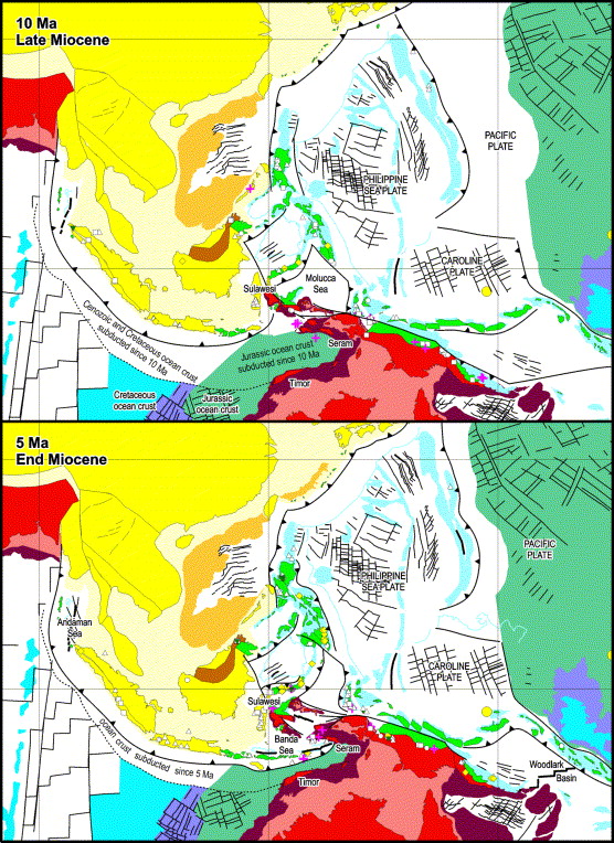
Reconstruction of SE Asia at 10 and 5 Ma showing the area of Indian Ocean crust subducted at the Sunda and Java Trenches. The arrival of Jurassic ocean crust at the trench south of Sulawesi is surmised to have caused rapid hinge rollback in eastern Indonesia, resulting in young volcanism in the Inner Banda Arc, and oceanic spreading in the Banda Sea. |
|
|
|
c
Robert Hall Journal of Asian Earth Sciences
Volume 20, Issue 4, April 2002, Pages 353ľ431
http://www.sciencedirect.com/science/article/pii/S1367912001000694
Cenozoic geological and plate tectonic evolution of SE Asia and the SW Pacific: computer-based reconstructions, model and animations
A plate tectonic model for the Cenozoic development of the region of SE Asia and the SW Pacific is presented and its implications are discussed. The model is accompanied by computer animations in a variety of formats, which can be viewed on most desktop computers. GPS measurements and present seismicity illustrate the high rates of motions and tectonic complexity of the region, but provide little help in long-term reconstruction. Plate boundaries shifted rapidly in the Cenozoic. During convergence of the major plates, there were numerous important episodes of extension, forming ocean basins and causing subsidence within continental regions, probably driven by subduction. Within eastern Indonesia, New Guinea and the Melanesian arcs, there are multiple Cenozoic sutures, with very short histories compared to most well-known older orogenic belts. They preserve a record of major changes in tectonics, including subduction polarity reversals, elimination of volcanic arcs, changing plate boundaries and extension within an overall contractional setting. Rapid tectonic changes have occurred within periods of less than 5 Ma. Many events would be overlooked or ignored in older orogenic belts, even when evidence is preserved, because high resolution dating is required to identify them, and the inference of almost simultaneous contraction and extension seems contradictory.
There were three important periods in regional development: at about 45, 25 and 5 Ma. At these times, plate boundaries and motions changed, probably because of major collision events. The 45 Ma plate reorganisation may be related to IndiaľAsia collision, although some important intra-Pacific events, such as voluminous Eocene boninite magmatism, seem to be older and require other causes. Indentation of Asia by India modified the Asian continent, but there is little indication that India has been the driving force of tectonics in most of SE Asia. The most important Cenozoic plate boundary reorganisation was at about 25 Ma. The New Guinea passive margin collided with the East PhilippinesľHalmaheraľSouth Caroline Arc system. The Australian margin, in the Bird''s Head region, also began to collide with the SE Asian margin in Sulawesi. The Ontong Java Plateau collided with the Melanesian Arc. These collisions caused a major change in the character of plate boundaries between about 25 and 20 Ma. Since 25 Ma, tectonic events east of Eurasia were driven by motion of the Pacific Plate. Further, west, the movement of Australia northwards caused rotations of blocks and accretion of microcontinental fragments to SE Asia. Plate motions and boundaries changed again at about 5 Ma, for uncertain reasons, possibly as a consequence of Pacific Plate motion changes, arcľcontinent collision in Taiwan, or other boundary changes at the Pacific margin, for example in the Philippines.
Areas to the west and east of New Guinea, the Banda Sea and Woodlark Basin, illustrate the speed of change, the unexpected interplay of convergence and extension, and the importance of subduction as the engine of change. Subduction has been the principal driving mechanism for tectonic change, although its manifestations are varied. They include collision-related phenomena, partitioning of oblique convergence, and effects of hinge roll-back and pull forces of subducting slabs. Magmatism is not always associated with subduction, depending on the movement of subduction hinge, and there may be important extension of the upper plate both perpendicular and parallel to the length of subduction zones. Strike-slip faulting is observably very important within the PacificľAustraliaľEurasia convergent setting, yet appears in few tectonic models. Long-term strike-slip deformation can explain some of the complexities of areas such as New Guinea, including magmatism and its absence, and thermo-chronological data showing very young and rapid cooling of the mobile belt and fold belt.
The inadequacies of the tectonic model reflect in part the difficulties of applying rigid plate tectonics, when there is clear evidence of changing shapes of fragments. Geological knowledge of the region is still inadequate and significant improvements to regional data sets, such as palaeomagnetic data and isotopic ages, are required. New tomographic techniques offer an important means of testing this and other reconstructions. However, valuable insights could also be obtained from simple data sets, such as sediment volumes, if more information that is complete were available in the public domain. Two-dimensional plate tectonic cartoons of small areas are no longer adequate descriptions or tools for understanding. It is essential to test plate tectonic models by using animation techniques with reconstructions drawn at short time intervals, which expose flaws in models, show major gaps in knowledge and help identify truly regional events. Observations of present-day tectonics, and all geological evidence, indicate that the model presented here is over-simplified. Improvements in this, or new models, will inevitably be more complex than the reconstructions described here.
C http://eswww.rhul.ac.uk/geode/SWPacific.html Global continental and ocean basin reconstructions since 200 Ma
The purpose of the workshop was:
Ľ to review geological and geophysical knowledge of the structure and tectonic evolution of volcanic arcs and arc/continent collisions in the SW Pacific region
Ľ Review of the structure and tectonic evolution of volcanic arcs and arc/continent collisions
Ľ Plate reconstructions for the Cenozoic ľ Robert Hall (Royal Holloway, r.hall@gl.rhbnc.ac.uk):
Ľ Presenting plate reconstructions covering the whole SE Asian and SW Pacific region, created at 1 Ma intervals for the past 50 Ma, Robert Hall pointed out the amount of extension that has occurred with a region of long- term convergence. This was particularly apparent across the large region of Sundaland and the Banda Sea behind the Banda Arc. He also emphasised the speed with which the tectonic regime changes, pointing to the Woodlark Basin which is currently disappearing as fast as it is forming, so that no trace of it will remain after another 2ľ3 million years. East of Sundaland there is virtually no influence from the India/Asia collision and the tectonics are dominated by the movement of Australia and a range of subduction-related stresses, the slab pull and gravity being the major forces. An important factor is the changing character of subduction, sometimes abruptly, that occurs when the nature of either the overriding or the subducting plate changes. An example of this was a movement of the Banda Arc from ca. 10 Ma when relatively old oceanic lithosphere began to be subducted in place of relatively young lithosphere at the Java Trench. The net result was a steepening of the slab and hinge retreat, which led to an increase in the rate of subduction and a rapid extension in the back arc area. Areas of hinge retreat are also characterised by marginal basins and significant arc volcanism, whereas in areas where the hinge has advanced volcanism often ceases as the mantle wedge is not continually being replenished by fresh mantle material. He intends to produce the plate reconstructions on a CD disc later this year, so that they can be viewed either singly or as an animation.
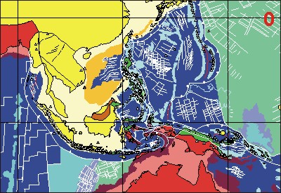
Ľ Figures 1 and 2 illustrate SE Asia centred on Banda Sea at 10 and 0 Ma, before and after the rapid hinge retreat. The 10 Ma figure shows the amount of crust subducted since 10 Ma and Jurassic crust off NW Australia is shown in a green shade.
Ľ Hall, R., 1996. Reconstructing Cenozoic SE Asia. In: Hall, R. & Blundell, D.J. (Eds.), Tectonic Evolution of SE Asia. Geological Society of London Special Publication 106, 153ľ84.
Ľ Hall, R., 1998. The plate tectonics of Cenozoic SE Asia and the distribution of land and sea. In Hall, R. & Holloway, J. D. (Eds.), Biogeography and Geological Evolution of SE Asia. Backhuys Publishers, Leiden, the Netherlands, 99ľ131.
Ľ Macpherson, C.G. & Hall, R., 1999. Tectonic controls of geochemical evolution in arc magmatism of SE Asia. PACRIM ''99 Congress, Australian Institute of Mining and Metallurgy Report 4/99, 359ľ68.
Ľ Tectonic evolution of the Philippines and Papua New Guinea ľManuel Pubellier (Paris, pubellie@opale.ens.fr):
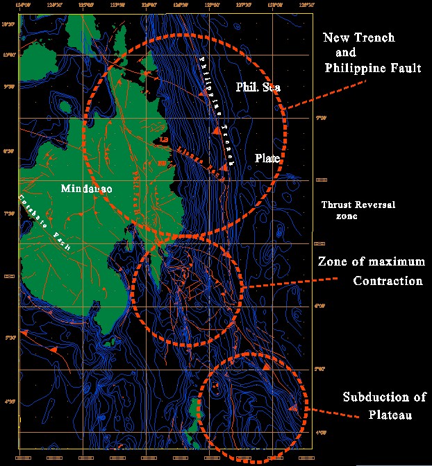
Ľ Manuel Pubellier emphasised the high rates of deformation processes, which require the study of a modern, active setting in order to appreciate and measure them. He pointed out that during an arcľcontinent collision there is a large amount of syn-tectonic magmatic activity and a rapid change in tectonic setting. A shift from subduction plateau to short-lived collision and new subduction can occur within 1 million years (see Figure 3 below).
Ľ In New Guinea, gold deposits are associated with thrusts and lateral ramps ľ Syntectonic porphyry Cu was injected between 7 and 2 Ma into thrust planes and then cut by later thrust planes. The tectonic setting changed again after 2 Ma becoming wrenching at the front of the belt, the lateral ramps subsequently becoming reactivated as normal faults. Mineralisation may come with one phase and be destroyed by the next one. These rapidly evolving systems show how essential it is to have accurate dating of events and underline the over-simplification that we make when we try to understand ancient orogens.
Ľ Seismic tomography and the mantle beneath SE Asia ľ Wim Spakman & Harmen Bijwaard (Utrecht, wims@terra.geo.uu.nl )
Cenozoic geological and plate tectonic evolution of SE Asia and the SW Pacific
Global continental and ocean basin reconstructions since 200 Ma
Cenozoic tectonic and depth/age evolution of the Indonesian gateway and associated back-arc basins