 | South East Azia arches |
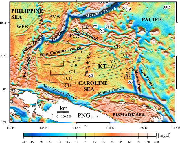
Gravity anomaly derived from satellite altimetry (Sandwell and Smith, 2005) for the Caroline sea region. Superimposed are the interpreted magnetic lineations (C8¢C16 stand for chron numbers, see detailed interpretation in Fig. 3 and Fig. 4). Locations of DSDP and ODP drilling are shown in white boxes. Abbreviations: CR Ś Caroline Ridge, PKR Ś Palau Kyushu Ridge, WCR Ś West Caroline Ridge, KT Ś Kiilsgaard Trough, PVB Ś Parece Vela Basin, WPB Ś West Philippine Basin |
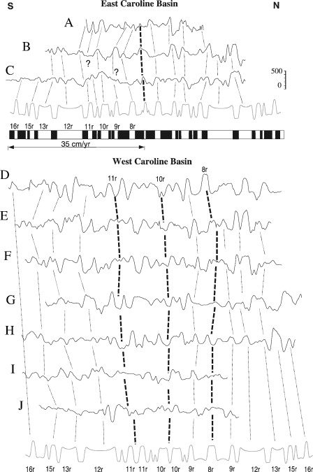
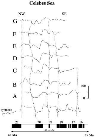
Selected magnetic anomaly profiles of the Caroline Basin (see location in Fig. 4) compared with synthetic magnetic anomalies. The synthetic profiles are based on the Cande and Kent (1995) geomagnetic timescale |
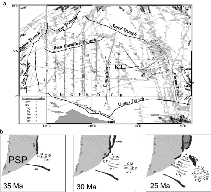
a. Magnetic anomalies along track in the Caroline basin and identified magnetic anomaly picks. b. Set of reconstructions of Caroline Sea isochrons relative to a fixed Philippine Sea Basin (PSB). Note the northward ridge jump in the west Caroline basin, possibly due to the presence of a hotspot (HS). Abbreviations for island arcs are CA Ś Caroline Arc, PKR Ś Palau Kyushu Ridge, PA Ś Palau Arc, WMR Ś West Mariana Ridge. |
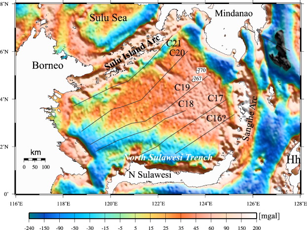
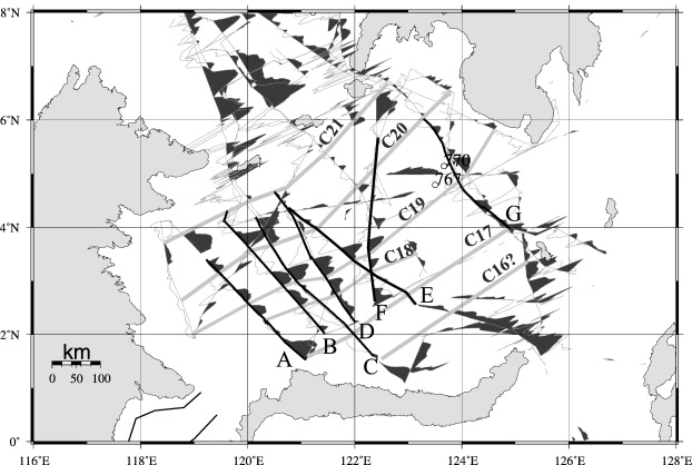
Gravity anomalies derived from satellite altimetry (Sandwell and Smith, 2005) for the Celebes Sea region. Superimposed are interpreted seafloor isochrons. Hh is Halmahera |
Selected magnetic anomaly profiles from the Celebes Basin (see location in Fig. 7) compared with synthetic magnetic anomalies |
Magnetic anomalies along track in the Celebes Sea |
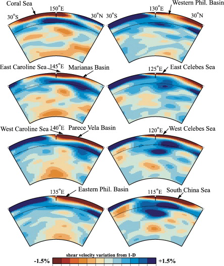
Regional N¢S shear wave mantle tomography cross sections from (Ritsema, 2004); 670 km boundary shown as thin, dotted line |
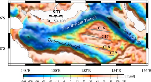
Gravity anomalies derived from satellite altimetry (Sandwell and Smith, 2005) for the Solomon Sea region. Superimposed are interpreted seafloor isochrons |
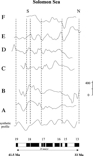
Selected magnetic anomaly profiles from the Solomon Sea (see location in Fig. 11) compared with synthetic magnetic anomalies |
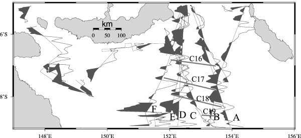
Magnetic anomalies along track and interpreted seafloor isochrons in the Solomon Sea |
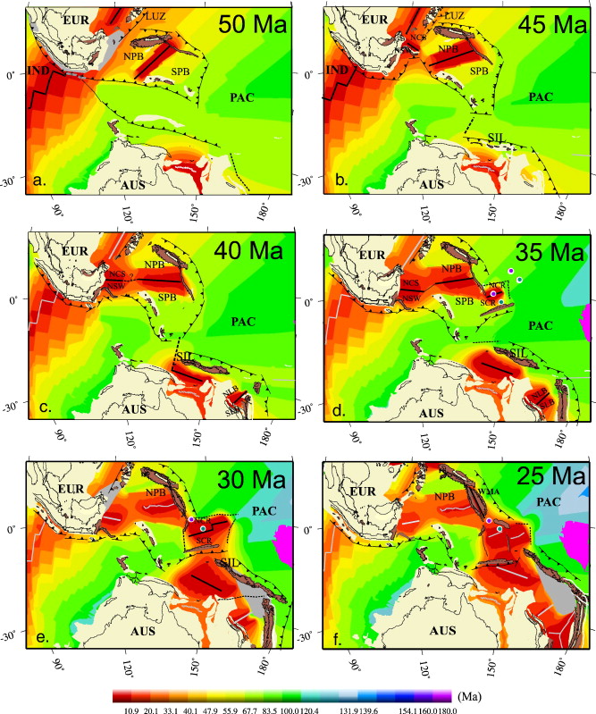
Set of tectonic reconstructions that depict the evolution of oceanic crust north of Australia since Middle Eocene (50 Ma). Light yellow represent continental blocks, rotated present day coastline are in black, island arcs are colored in pale brown. Grey areas depict regions with insufficient data to constrain paleo-age grids. Black lines are active plate boundaries (if dashed Ś unconstrained plate boundary), light grey lines are extinct spreading ridges. The two blue circles show the location of the Manus (west) and Caroline (east) hotspots assuming an underlying Pacific mantle. An additional position for the Manus hotspot depicts its location if part of moving Indian Ocean hotspot (green circle). Large Igneous Provinces (in this case Ontong Java Plateau, NE of Australia and Kerguelen and Broken Ridge plateaus, SWof Australia) are colored in magenta. The active tectonic plates are mentioned as following: PAC Ś Pacific Ocean, AUS Ś Australia, IND Ś Indian plate, EUR Ś Eurasia, LUZ Ś Luzon, NPB and SPB Ś North and South Philippine Basin, NCS Ś North China Sea, NSW Ś North Sulawesi Arm, SIL Ś Solomon Islands, NLB and SLB Ś North and South Loyalty Basin, NCR and SCR Ś North and South Caroline Basin, P¢M -, SI Ś Sulu Island Arc. Present day age grid abbreviations: Oceanic basins: AAP Ś Argo Abyssal Plain, SO Ś Southern Ocean, SCS Ś South China Sea, WPS Ś West Philippine Basin, PVB Ś Parece Vela basin, WMB Ś West Mariana basin, Su Ś Sulu Sea, CeS Ś Celebes Sea, MSt Ś Makassar Strait, MS Ś Molucca Sea, SBS Ś South Banda Sea, CaS Ś Caroline Sea, BS Ś Bismark Sea, SS Ś Solomon Sea, CoS Ś Coral Sea, LT Ś Louisiade Trough, CT Ś Cato Trough, TS Ś Tasman Sea, NFB Ś North Fiji Basin, SFB Ś South Fiji Basin, Dec Ś DEntrecasteaux, WB Ś Wharton Basin; Volcanic arcs (with possible continental remains): PA Ś Philippine Islands Archipelago, IB Ś Izu Bonin, Lz Ś Luzon, Hh Ś Halmahera, Nsw Ś North Sulawesi, SSw Ś South Sulawesi, SESw Ś SE Sulawesi, Jv Ś Java, Sum Ś Sumatra, MA Ś Melanesian Arc, SI Ś Solomon Islands, WMA Ś West Mariana Arc; Hotspots: CHS Ś Caroline hotspot, MHS Ś Manus hotspot. |
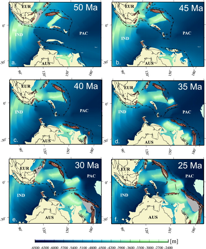
Reconstructions of paleobathymetry north of Australia since Middle Eocene (50 Ma). See legend from the previous figure |
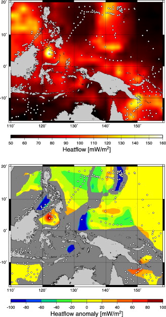
Modelled (Shapiro and Ritzwoller, 2004) heatflow and predicted heatflow based on our oceanic agegrid north of Australia. White dots show the locations of heatflow data (Nyblade and Pollack, 1993). |
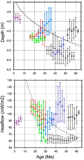
Residual depth vs. age and anomalous heatflow vs. age with standard deviation error bars and a thermal boundary layer model (solid line) and plate model (dashed line) from Parsons and Sclater (1977) superimposed (colors are: Caroline Ś light blue (filled), Mariana Ś magenta, Shikoku Ś green (filled), Celebes Ś blue, Philippine Ś gray (filled), Coral Ś black, S China Sea Ś red). |
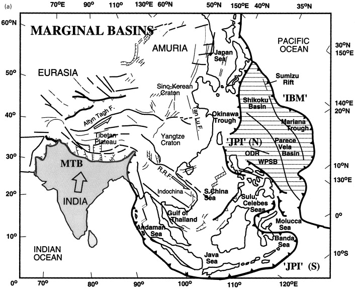
Maps of eastern Eurasia: (a) marginal basins; (b) volcanic arcs, showing major tectonic features in eastern Eurasia, the western Pacific and northeastern Indian Ocean, Indian indentor (shaded) and Philippine Sea plate (horizontal lines); Major faults shown by thin grey lines, subduction zones (with solid barbs) and thrust zones (open barbs) by thick grey lines. IBM Ś Izu-Bonin-Mariana line; JPI Ś Japanese¢Philippine¢Indonesian line; MTB Ś Main Thrust Belt of the India-Asian collision; RRF Ś Red River Fault; WPSB Ś West Philippine Sea Basin; ODR Ś Oki Daito Ridge http://www.sciencedirect.com/science/article/pii/S004019510000264X |
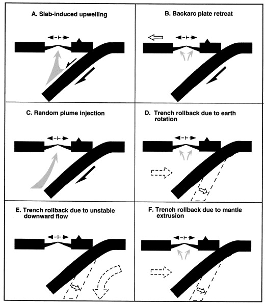
Alternative mechanisms of back-arc basin formation (following Tamaki and Honza, 1991): (A) slab-induced asthenosphere upwelling (Karig, 1971); (B) backarc plate retreat effect as part of a global kinematic response (Sleep and Toksцz, 1971); (C) random plume injection from deeper mantle ( and ); (D) eastward trench rollback due to earth rotation (, , and ); (E) trench rollback due to unstable downward flow (Uyeda and Kanamori, 1979); and (F) trench rollback due to mantle extrusion |
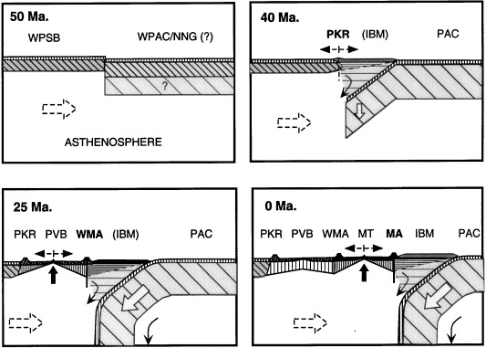
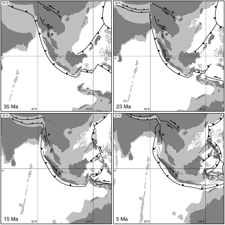
Schematic history of the IBM forearc between ca. 50 Ma. and the present (after , , , , , and ): (a) 50¢40 Ma. Subduction initiation beneath West Philippine Sea Basin (WPSB) plate either by the Pacific (PAC) plate or (hypothetical) young North New Guinea (NNG) plate (Seno and Maruyama, 1984) (see Fig. 4a) along transform fracture zone in proto-WPSB spreading center. Boninite melt genesis accompanies early forearc development with inception of the calcalkaline arc forming the Palau-Kyushu ridge (PKR). (b) 40¢25 Ma. Continued subduction with slab steepening of the Pacific plate, splitting of the Palau-Kyushu arc, Parece Vela basin (PVB) opening, and rollback of the active West Mariana arc (WMA). (c) 25¢0 Ma. Continued subduction, Mariana Trough (MT) opening by splitting of the West Mariana arc, and rollback of the active Mariana arc (MA). (d) 0 Ma. Subduction beneath the modern Mariana arc-trench system with continued Mariana Trough opening by æunzippingÆ of the West Mariana-Mariana arc to the north (Iwo Jima) |
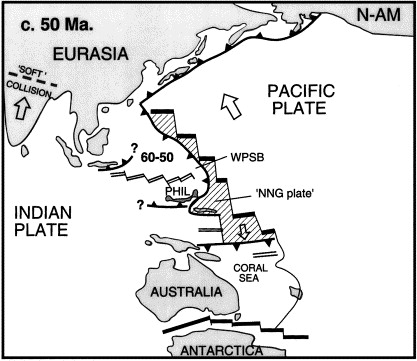
Schematic plate geometry at ca. 50 Ma: showing origin of the West Philippine Sea Basin (WPSB), subduction of hypothetical North New Guinea plate (NNGP) prior to initiation of Palau-Kyushu (PKR) subduction (after Seno and Maruyama, 1984), with possible initiation of the Sunda plate formation indicated |
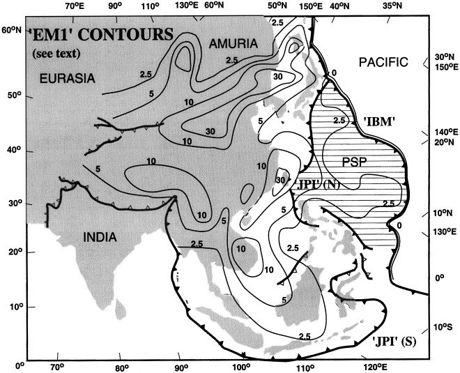
Asia-western Pacific æEM1Æ (i.e. the EM1-like æSKCÆ component) distribution as a proportion of binary mixing between æN-MORBÆ (DMM+HIMU) and EM1-computed from basalt trace element and isotopic compositions assuming bulk mantle comprises DMM, HIMU, EM1, and EM2 ( and ) within the east Asia-western Pacific mantle isotopic province. Because DUPAL compositions (strictly defined; Hart, 1984) may include both oceanic EM1 and EM2 mantle endmember components), we have computed æcontaminantÆ contents in terms of such endmembers rather than the more conventional ─8/4Pb and ─7/4Pb parameters (æverticalÆ deflections of 208Pb/204Pb, and 207Pb/204Pb from NHRL on isotopic æPb¢PbÆ diagrams). To the east, a broad Pacific domain is dominated by isotopically ænormalÆ mid-ocean ridge basalt (N-MORB) consistent with simple mixing of DMM and HIMU mantle components. Sr, Nd, and Pb isotopic data for Neogene and Quaternary basalt eruptives in the east Asia-western Pacific region show that isotopically-anomalous mantle extends from Indonesia in the south to eastern Siberia, and that its eastern rim (EM1=0) is marked by the (Kurile), Japanese, Izu-Bonin, and Mariana volcanic arcs. These accreted active and relict subduction-related complexes reflect a diachronous pattern of arc sundering, trench rollback, and concomitant basin opening and may be interpreted as litho-tectonic æhigh-tide marksÆ. To the south and southwest the east Asia-western Pacific province is separated from the Indian Ocean by the Andaman-Nicobar and Indonesian archipelagoes, while to the east and northeast of Australia, the New Hebrides, Tonga, and Kermadec arcs separate analogous DUPAL-like basins from the Pacific N-MORB domain. |
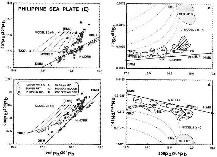
Plots of 207Pb/204Pb, 208Pb/204Pb versus 206Pb/204Pb, and 87Sr/86Sr, 143Nd/144Nd versus 206Pb/204Pb for the Philippine Sea plate (east): including compositions for the Parece Vela Basin (PVB), Mariana Trough (MT1 Ś northern trough; MT2-northern ridge; MT3-southern ridge) (, and ), Shikoku Basin (SB) (Hickey-Vargas, 1991), Sumizu Rift (SR) ( and ), the Mariana arc (MA) (Elliot et al., 1997), and Izu-Bonin arc (IB1 Ś ca. 41 Ma.; IB2 Ś ca. 35 Ma.; IB3 Ś ca. 17 Ma.; IB4 Ś ca. 10 Ma.) ( and ), compared with hypothetical mantle mixing models 1¢3 |
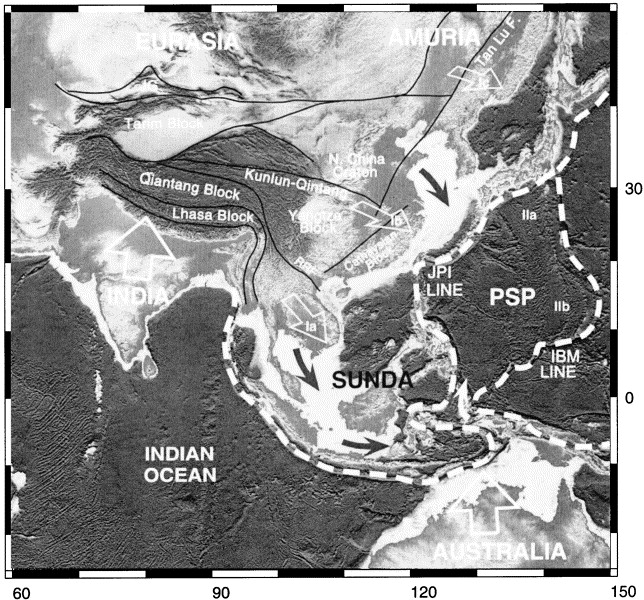
Topographic map of eastern Eurasia, Australia, western Pacific, and northeastern Indian Ocean, showing inferred tectonic ælobesÆ. An inner lobe series (Ia-c) is bounded by the Japan¢Philippine¢Indonesia (JPI) line-Indonesian and Philippine arcs (enclosing the South China Sea and Indochina), the Ryuku arc (enclosing the Okinawa Trough and mainland China), and Japanese arc (enclosing the Japan Sea, Korea, and southeastern Siberia), corresponding respectively with the Indochinese, Chinese, and Amurian æplatesÆ. An outer lobe (IIa, b) bounded by the Izu-Bonin-Mariana (IBM) line Ś the Izu-Bonins enclosing the Sumisu Rift and Shikoku Basin (IIa), and Marianas (IIb) enclosing Parece Vela and the Mariana Trough Ś may also be related to Indo-Asian collision effects. |
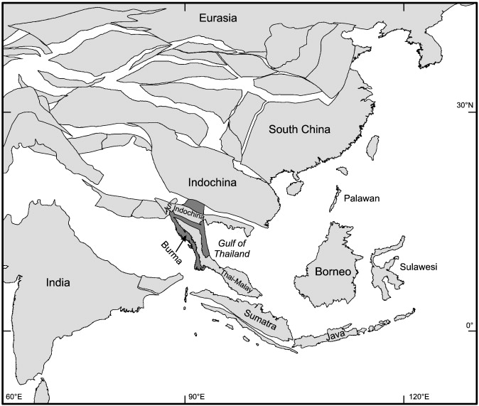
Reconstruction of SE Asia region at 40 Ma modified from Hall (2002). Light shaded areas are continental shelf areas Impact of India¢Asia collision on SE Asia: The record in Borneo .Borneo occupies a central position in the Sundaland promontory of SE Asia. It has a complex Cenozoic geological history of sedimentation and deformation which began at about the same time that India is commonly suggested to have started to collide with Asia. Some tectonic reconstructions of east and SE Asia interpret a large SE Asian block with Borneo at its centre which has been rotated clockwise and displaced southwards along major strike¢slip faults during the Cenozoic due to the indentation of Asia by India. However, the geological history of Borneo is not consistent with the island simply forming part of a large block extruded from Asia. The large clockwise rotations and displacements predicted by the indentor model for Borneo are incompatible with palaeomagnetic evidence and there is no evidence that the major strike¢slip faults of the Asian mainland reach Borneo. Seismic tomography shows there is a deep high velocity anomaly in the lower mantle beneath SE Asia interpreted as subducted lithosphere but it can be explained just as well by alternative tectonic models as by the indentor model. Very great thicknesses of Cenozoic sediments are present in Borneo and circum-Borneo basins, and large amounts of sediment were transported to the Crocker turbidite fan of north Borneo from the Eocene to the Early Miocene, but all evidence indicates that these sediments were derived from local sources and not from distant sources in Asia elevated by India¢Asia collision. The Cenozoic geological history of Borneo records subduction of the proto-South China Sea and Miocene collision after this ocean lithosphere was eliminated, and a variety of effects resulting from long-term subduction beneath SE Asia. There is little to indicate that India¢Asia collision has influenced the Cenozoic geological record in Borneo.http://www.sciencedirect.com/science/article/pii/S0040195107004295 |
http://www.sciencedirect.com/science/article/pii/S0040195107004295 |
From http://www.sciencedirect.com/science/article/pii/S0012825207000542
Cenozoic tectonic and depth/age evolution of the Indonesian gateway and associated back-arc basins
Reconstruct the tectonic and paleo-age and -depth history of the Indonesian seaway and associated southeast Asian back-arc basins to create a comprehensive paleogeographic framework for the region during the Cenozoic. We combine published tectonic models with revised models of the evolution of back-arc basins based on available marine magnetic anomaly data and a recently published high-resolution (1 min) marine gravity anomaly grid which reveals many fine-scale tectonic features previously not resolved. Reconstructions of the now-subducted Ceno-Tethys ocean floor are integrated with a revised absolute plate motion reference frame for the Indian Ocean based on moving hotspots. All marginal seas north of Australia formed in a back-arc setting, with the Caroline and Celebes seas opening north of a northward dipping subduction zone, and the Solomon Sea south of a southward dipping subduction zone north of Australia. We suggest that the evolution of the two sub-basins of the Caroline Sea from 36 to 25 Ma followed different seafloor spreading patterns, with the western sub-basin being influenced by the Manus hotspot. Our model suggests that collision between the Melanesian and the Caroline arcs led to cessation of oceanic crustal production in the Caroline Basin shortly before 25 Ma. Combined geophysical and geological observations suggest that several major tectonic events occurred north of Australia at around 45 Ma, roughly at the time when Australia started moving northwards at fast rates similar to the present. We suggest that this event is related to a relocation of the subduction zone NW of Australia under the Philippine Sea plate due to a collision and subsequent accretion of old Pacific plate material to the northward subducting Australian plate. Our gridded oceanic paleo-depth maps capture the history of marginal seas north of Australia, and the stepwise destruction of the Ceno-Tethys ocean floor in the northern Wharton Basin and the west Pacific, providing boundary conditions for both paleoceanograpic and geodynamic models. A regional analysis of basement depth anomalies reveals that median negative anomalous depth of several back-arc basins is of the order of 650¢800 m, with a range of 300¢1100 m, accompanied by negative regional heatflow anomalies, suggesting that mantle-driven dynamic topography plays a larger role in modulating regional basement depth than previously suggested. Regional shear wave mantle tomography cross sections highlight that all marginal basins that exhibit large negative dynamic topography are underlain by massive buried slab material in the lower portion of the upper mantle and/or below the transition zone, supporting the notion that the observed paired negative dynamic topography and heatflow anomalies are due to basin formation above slab burial grounds.
The Philippine archipelago is regarded as the product of the Late Cenozoic oblique collision of the Philippine Plate with the thinned margin of Eurasia. The Philippine Mobile Belt is presented, mainly composed by the Philippine arc, a Paleogene volcanic arc belonging to the Philippine Sea Plate and crustal fragments belonging to the Eurasian Plate. Kinematic and geological data are presented for this collision history - http://www.sciencedirect.com/science/article/pii/0743954791900689
Mantle contamination and the Izu-Bonin-Mariana (IBM) æhigh-tide markÆ: evidence for mantle extrusion caused by Tethyan closure
Western Pacific basins are characterized by three remarkable attributes: (1) complex kinematic histories linked to global-scale plate interactions; (2) DUPAL-like contaminated mantle; and (3) rapid post-Mesozoic rollback of the confining arc-trench systems. The coincidence of slab steepening, extreme arc curvature, and vigorous basin opening associated with the Mariana convergent margin suggests that rollback continues in response to an east-directed mantle æwindÆ. Against a backdrop of conflicting kinematic and genetic interpretations we explore the notion that eastward asthenospheric flow driven by diachronous Tethyan closure caused stretching of eastern Eurasia and concomitant opening of western Pacific basins. Marking the eastern boundary of the latter, the Izu-Bonin-Mariana forearc may be regarded as a litho-tectonic æhigh-tide markÆ comprising igneous and metamorphic products from successive episodes (since ca. 45 Ma.) of arc sundering and backarc basin opening. The forearc also forms an isotopic boundary separating contaminated western Pacific mantle from the N-MORB Pacific Ocean reservoir. While the isotopic composition of western Pacific mantle resembles that feeding Indian Ocean hotspot and spreading systems, its spatial¢temporal variation and the presence of subduction barriers to the south appear to preclude northward flow of Indian Ocean mantle and require an endogenous origin for sub-Eurasian contaminated mantle. It is concluded that the extrusion of Tethyan asthenosphere, contaminated by sub-Asian cratonic lithosphere, was a major cause of western Pacific arc rollback and basin opening. The model is consistent with paleomagnetic and geologic evidence supporting independent kinematic histories for constituent parts of the Philippine Sea and Sunda plates although interpretation of these is speculative. Compounded by effects of the Australia¢Indonesia collision, late-Tethyan mantle extrusion appears to have produced the largest DUPAL domain in the northern hemisphere, Keywords backarc basin; arc rollback; asthenosphere; ophiolite; isotopic anomaly; mantle wind; extrusion -
http://www.sciencedirect.com/science/article/pii/S004019510000264X