 | White Mountains - Fort Sage Mountains - Lemmon Valley- Glass Mountain- Virginia - Pah Rah Ranges |
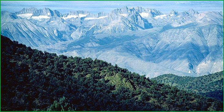
White Mountains James R. Nelson |
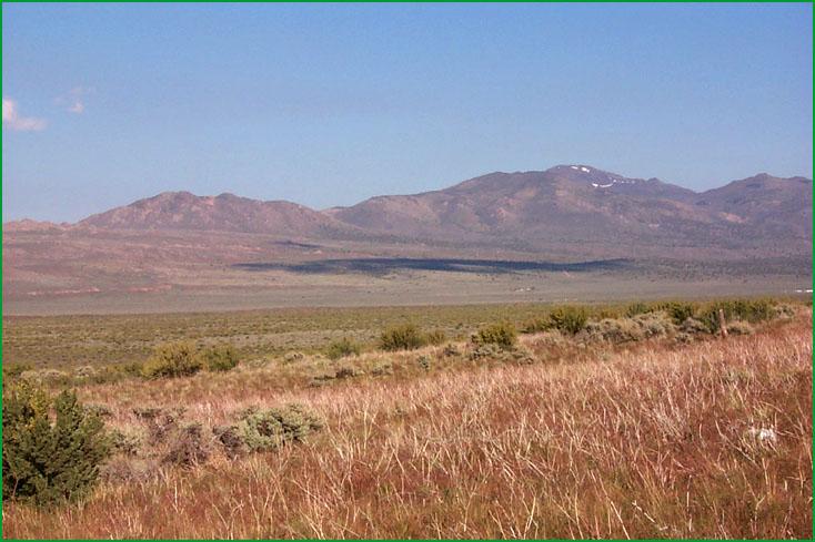
Fort Sage Mountains - Lemmon Valley -Subsection 341Dk background, 342Bc in foreground, Doyle area Scott Miles |
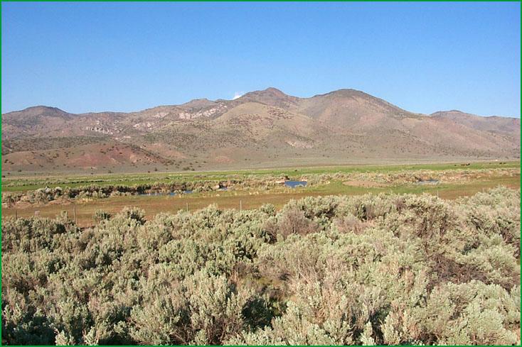
South of Doyle Scott Miles |
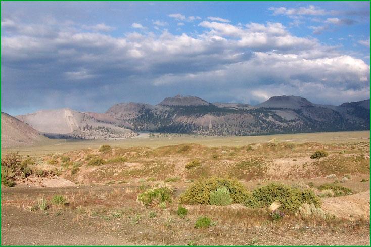
Glass Mountain, South of Lee Vining Scott Miles |
http://www.fs.fed.us/r5/projects/ecoregions/341dj.htm
Subsection 341Dj
White Mountains
This subsection comprises the White Mountains, the highest mountain range in the Great Basin. It has a temperate to very cold, arid to semi-arid climate. MLRA 26f.
Lithology and Stratigraphy. Mesozoic granitic, Cambrian marine sedimentary, Precambrian sedimentary and Pre-Cretaceous metamorphic rocks predominate in this subsection. There is Quaternary glacial till in many of the canyons on the east side of the mountains, but it is not extensive.
Geomorphology. The landforms are steep to very steep mountains with narrow to broad ridge tops. They are aligned toward the north-northeast. The elevation range is from about 5000 feet up to 14,246 feet on White Mountain Peak. Much of the main ridge is above 12,000 feet. Mass wasting, fluvial erosion, and freeze-thaw are the main geomorphic processes.
Soils. The soils are mostly shallow in Typic subgroups of Torriorthents, Cryopsamments, and Haplargids, shallow Entic Haploxerolls, and Dystric Xeropsamments on granitic rocks and Lithic Torriorthents, Lithic Xerollic Haplargids, and Typic and Aridic Argixerolls on other kinds of rocks. The soils are well drained. Soil temperature regimes are mesic, frigid, and cryic. Soil moisture regimes are mostly aridic, and some xeric.
Vegetation. The predominant natural plant communities are Shadscale series at lower elevations; Big sagebrush, Utah juniper, and Singleleaf pinyon series at intermediate elevations; Five-leaved pine forest alliances at higher elevations; and communities of Alpine habitats at the highest elevations. At intermediate elevations, Low sagebrush series is common on shallow soils and Black sagebrush series is common on limestone and dolomite. At higher elevations, the five-leaved pine forests are Limber pine series on granitic rocks and Bristlecone pine series on limestone and dolomite. Curlleaf mountain mahogany is another common series. Aspen series occurs on the east slopes of the mountain range. Lodgepole pine series is less common.
Characteristic series by lifeform include:
Grasslands: Alpine habitat, Beaked sedge series, Creeping ryegrass series, Indian ricegrass series, Nebraska sedge series, Needle-and-thread series, Rocky Mountain series, Short sedge series, Tufted hairgrass series.
Shrublands: Allscale series, Big sagebrush series, Black sagebrush series, Bittlebrush series, Fourwing saltbush series, Low sagebrush series, Mixed saltbush series, Shadscale series,
Forests and woodlands: Aspen series, Bristlecone pine series, Curlleaf mountain-mahogany series, Limber pine series, Lodgepole pine series, Singleleaf pinyon series, Singleleaf pinyon Utah juniper series, Utah juniper series.
Climate. The mean annual precipitation is about 8 to 20 inches. Much of the precipitation is snow. Mean annual temperature is about 30¯ to 50¯ F. The mean freeze-free period is in the range from < 25 to 150 days.
Surface Water. Runoff is rapid. Steams are dry most of each year.
Subsection 341Dk
Fort Sage Mountains - Lemmon Valley
This subsection includes mountains, hills, and valleys between the Sierra Nevada on the west and the Pah Rah Range and Pyramid Lake on the east. The larger mountains are the Fort Sage Mountains, Virginia Mountains, Dogskin Mountain, and Petersen Mountain. The larger valleys are Long Valley, Lemmon Valley, and Warm Springs Valley. The climate is temperate to cold, and semi-arid. MLRA 26F.
Lithology and Stratigraphy. Tertiary basalt predominates in the mountains and hills. Also, there are Cenozoic tuff and tuffaceous sediments and Quaternary basalt. Mesozoic granitic and Pre-Cretaceous metavolcanic rocks are exposed beneath the volcanic rocks on the western side of the subsection. The valleys contain Quaternary alluvial and lacustrine deposits. Tertiary lacustrine deposits are extensive in Long Valley.
Geomorphology. This subsection contains steep mountains, moderately steep hills, gently to moderately sloping alluvial fans, and nearly level floodplains and basin floors. The mountains are aligned north-south in the southern and eastern parts of the subsection, curving around to the northwest in the northwestern part. The elevation range is from about 4000 feet adjacent to Pyramid Lake up to 7990 feet in the Fort Sage Mountains and 8722 feet on Tule Peak in the Virginia Mountains. Mass wasting, fluvial erosion and deposition, and freeze-thaw are the main geomorphic processes.
Soils. The soils on mountains and hills are mostly Lithic, Aridic, Aridic Calcic, Aridic Pachic, and Pachic Argixerolls; Lithic Xerollic and Xerollic Haplargids; Entic Ultic Haploxerolls; and shallow Xerollic Durargids. Those on granitic rocks are mostly shallow Xeric Torripsamments, Torripsammentic and Entic Haploxerolls, and shallow Aridic and Ultic Argixerolls. Soils on alluvial fans are mostly Typic Torriorthents, Aridic Haploxerolls, Pachic Argixerolls, Xerollic Haplargids, and Abruptic Xerollic Durargids. Those on floodplains and basin floors are mostly Typic Xerofluvents, Aridic Cumulic Haploxerolls, Typic Haplaquepts, Typic Haplaquolls, Aquic Argixerolls, and Aquic Natrargids. Also, there are Chromoxererts on dry lake beds. The soils are well drained, except for somewhat poorly to poorly drained soils on floodplains and basin floors. Soil temperature regimes are mesic and frigid. Soil moisture regimes are mostly aridic at lower elevations and xeric at higher elevations. Ephemerally to permanently wet soils on floodplains and basin floors have xeric or aquic moisture regimes.
Vegetation. The predominant natural plant communities are Big sagebrush series at lower and Utah and Western juniper series at higher elevations. Shadscale series prevails at low elevations near Pyramid Lake. Greasewood series, Saltgrass series, and Sedge meadow alliances occur on somewhat poorly to poorly drained floodplains and basin floors. Low sagebrush series is common on shallow soils.
Characteristic series by lifeform include:
Grasslands: Alkali sacaton series, Ashy ryegrass series, Beaked sedge series, Bluebuch wheatgrass series, Cordgrass series, Creeping ryegrass series, Indian ricegrass series, Needle-and-thread series, Saltgrass series.
Shrublands: Allscale series, Big sagebrush series, Bitterbrush series, Bush seepweed series, Fourwing saltbush series, low sagebrush series, Mixed saltbush series, Rubber rabbitbrush series, Shadscale series, Winter fat series.
Forests and woodlands: Utah pinyon series, Mountain juniper series.
Climate. The mean annual precipitation is about 6 to 16 inches. Much of the precipitation is snow. Mean annual temperature is about 35¯ to 54¯ F. The mean freeze-free period is in the range from 75 to 150 days.
Surface Water. Runoff is rapid from alluvial fans and slow from basin floors. Some drainages are closed, with ephemeral lakes in the valleys, but much of the runoff is to Pyramid Lake or to Honey Lake.
Subsection 341Dl
Glass Mountain
This subsection encompasses volcanic peaks and craters on a volcanic plain northeast of the Sierra Nevada below Mammoth Pass, Little Antelope Valley, and a high ridge north of Long and Little Antelope Valleys. It has a cold to very cold, semi-arid to subhumid climate. MLRA 26f, and 22e.
Lithology and Stratigraphy. The bedrock is mainly Quaternary rhyolite, including obsidian, and tephra. Also, there is some Mesozoic volcanic rock and Pliocene basalt.
Geomorphology. This subsection contains mostly moderately steep mountains, a steep scarp on the north side of Long Valley Caldera, and gently to moderately sloping volcanic plain. The Inyo Craters are a series of hills in the same north-south alignment as the Mono Craters in subsection 341Dh. The highest land is on an east-west arc along the north edge of Long Valley Caldera. This oval caldera is a slightly elongated, east-west, depression formed by collapse about 3/4 million years ago of the vent for Bishop tuff. It is now occupied by the Little Antelope and Long Valleys and, in the center, a hill formed by volcanic activity following collapse of the vent. The elevation range is from about 7000 feet up to 11,123 feet on Glass Mountain. Volcanism, fluvial erosion and deposition, and freeze-thaw are the main geomorphic processes.
Soils. The soils are mostly Lithic and Lithic Ultic Argixerolls, Ultic Haploxeralfs, Dystric Xeropsamments, Andic Xerumbrepts, Dystric Xeropsamments, and shallow Typic Cryopsamments. Also, there are shallow Typic Torripsamments, Lithic Xerollic Haplargids, and Typic Argixerolls on granitic rocks. The soils are well drained. Soil temperature regimes are mostly frigid, and some cryic at higher elevations. Soil moisture regimes are mostly xeric, and some aridic.
Vegetation. The predominant natural plant community is Jeffrey pine series. White fir series is common at higher elevations, Lodgepole pine series occurs in cold-air drainage-ways, and Singleleaf pinyon series is common in dry areas. Other series in this subsection are Aspen in areas where snow accumulates, Bitterbrush, Big Sagebrush, and Curlleaf mountain mahogany. Willow thicket alliances occur in wet areas, and there are Subalpine meadow habitats. Pumice forb habitats are present, but lack a description.
Characteristic series by lifeform include:
Grasslands: Alpine habitat, Ashy ryegrass series, Indian ricegrass series, Beaked sedge series, Creeping ryegrass series, Indian ricegrass series, Nebraska sedge series, Needle-and-thread series.
Shrublands: Big sagebrush series, Bitterbush series, Low sagebrush series, Parry rabbitbrush series, Rubber rabbitbrush series, Tobacco brush series.
Forests and woodlands: Jeffrey pine series, Limber pine series, Lodgepole pine series, Red fir series, Singleleaf pinyon series, White fir series.
Climate. The mean annual precipitation is about 15 to 30 inches. Much of the precipitation is snow. Mean annual temperature is about 32¯ to 40¯ F. The mean freeze-free period is in the range from 25 to 150 days.
Surface Water. Runoff is rapid; most of the soils have high infiltration rates. Most of the runoff is to the Owens River, but some is to Mono Lake. Much of the area lacks integrated drainage systems, because of recent flows and tephra deposits. The Owens River and streams from the Sierra Nevada run water through the summer.
Subsection 341Dm
Virginia - Pah Rah Ranges
This subsection comprises the Virginia Range south of the Truckee River and the Pah Rah Range north of the Truckee River. The subsection is completely in Nevada and is included to complete the section. It has a cold, semi-arid climate. MLRA 26f.
Lithology and Stratigraphy. Tertiary andesite, and possibly some dacite, flows and breccias predominate in the Virginia Range. Tertiary basalt and andesite flows predominate in all but the northern part of the Pah Rah Range, where silicic ash-flow tuffs predominate. Tertiary tuffaceous sedimentary rocks are common in both ranges and Quaternary andesite flows and breccias are common in the Virginia Range. Small areas of Mesozoic granitic rocks and other kinds of Jurassic and Triassic rocks are present in both ranges.
Geomorphology. Steep mountain slopes predominate in this subsection. There are some volcanic plateaus, moderately steep hills, and gently to moderately sloping pediments and alluvial fans. Some small closed basins occur on the volcanic plateaus. The Truckee River flows on a narrow floodplain. The mountains are aligned toward the northeast on the southeast side of the Virginia Range, toward the northwest at the north end of the Pah Rah Range, and north-south in the middle and on the west sides of the Ranges. The elevation range is from about 4500 feet along the Truckee River to over 7600 feet on the ridge between Wakefield Peak and Orleans Hill in the Virginia Range and 8367 feet on Virginia Peak in the Pah Rah Mountains. Mass wasting, fluvial erosion and deposition, and freeze-thaw are the main geomorphic processes.
Soils. The soils are mostly Xerollic Haplargids and lesser amounts of Lithic Xerollic Haplargids, Torriorthentic Lithic and Aridic Pachic Haploxerolls, Aridic Pachic Argixerolls, and "bleached land." The "bleached land" is soft, hydrothermally altered volcanic rock with little soil. Small areas of Typic Chromoxererts occur on volcanic plateaus, on pediments, and in basins; and there are some Xerollic and shallow Palexerollic Durargids on alluvial fans. Typic and Aquic Xerorthents occur on floodplain along the Truckee River. The soils are well drained, except somewhat poorly drained soils along the Truckee River. Soil temperature regimes are mostly frigid, with mesic along the Truckee River. Soil moisture regimes are mostly aridic, bordering xeric, and some are xeric.
Vegetation. The predominant natural plant communities are Big sagebrush series and, at higher elevations, Utah and Western juniper series. Low sagebrush series is common on shallow soils, and Mixed chaparral shrublands are common on rocky and stony Haploxerolls and Argixerolls. Singleleaf pinyon series occurs on Aridic Pachic Haploxerolls. Jeffrey pine series occupies acid soils of "bleached land." Shadscale series occurs on shallow Durargids with mesic soil temperature regimes.
Characteristic series by lifeform are not provided for this subsection.
Climate. The mean annual precipitation is about 6 to 18 inches. Much of the precipitation is snow. Mean annual temperature is about 42¯ to 50¯ F. The mean freeze-free period is in the range from 100 to 125 days.
Surface Water. Runoff is rapid from the mountains and dissected volcanic plateaus, but there are some closed basins on volcanic plateaus. Most of the runoff drains to the Truckee River or its tributaries. The southern edge of the subsection is in the Carson River drainage basin and runoff from the northern part drains to Pyramid lake without passing through the Truckee River. Streams in the mountains are dry most of each year, although the Truckee River is a permanent stream. There is ephemeral ponding in some of the small closed basins, but there are no natural lakes in the subsection.