 | SEISMICITY |
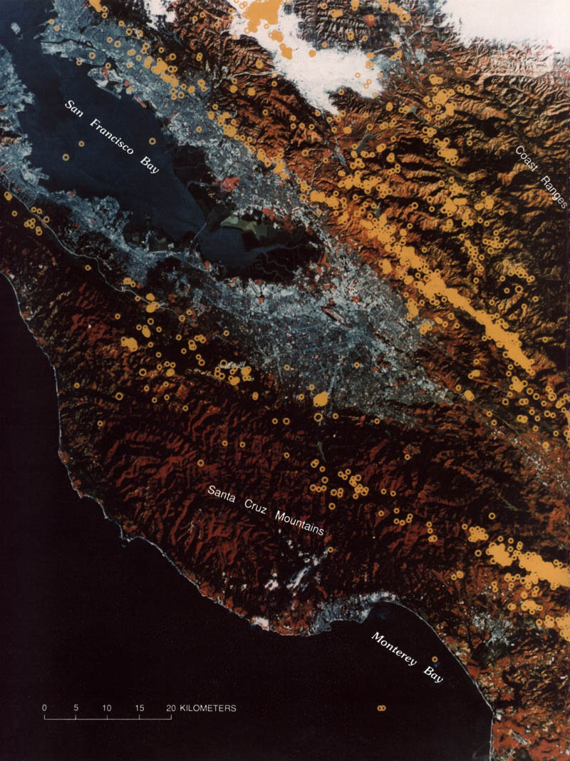
Seismicity from 1969 to 1980 superimposed on color Landsat image for the central Coast Ranges between the San Francisco Bay and Monterey Bay. Size of earthquake epicenters (yellow circles) increases with earthquake magnitude from 1. 5 to 6.0. Compiled by Jean Olsen |
Seismicity highlights broad and complex zones of active tectonism in the western United States. Dots, earthquakes scaled by magnitude in unit-magnitude steps, smallest for M<4; circles, earthquakes of M>7; red dots, recent events, generally since 1975; pink symbols, historical events. From Engdahl and Rinehart (1988). |
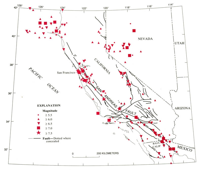
Seismicity of California, Nevada, and northern Baja California, 1769-1989. Earthquakes are listed in table 6.1 and plotted by magnitude class- http://geologycafe.com/california/pp1515/chapter6.html. |
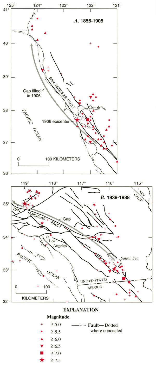
Where will the next great earthquake strike along the San Andreas fault system? Numerous lines of evidence point to its long-dormant southernmost segment (B) as having the highest potential. Large earthquake activity in this region shares many similarities with activity in the San Francisco Bay region before 1906 earthquake (A). In both cases, absence of activity directly on the San Andreas fault is pronounced, and a high regional level of activity is concentrated along other major branches of the fault system. |
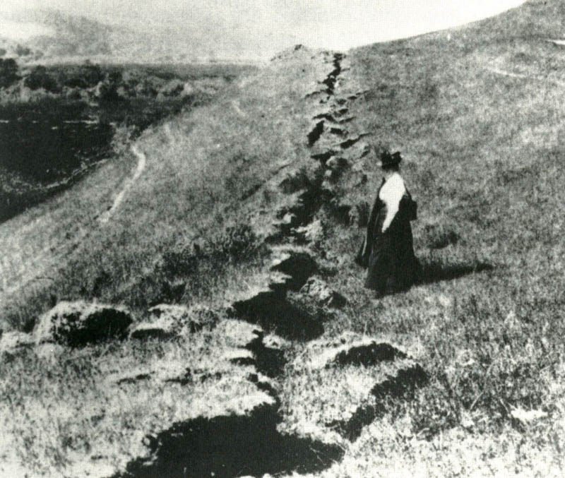
Trace of 1906 earthquake rupture near point of maximum offset (6 m) near Olema on the Point Reyes peninsula north of San Francisco. Photograph by G.K. Gilbert. View northwestward |
Fault trace of 1915 Pleasant Valley, Nev., earthquake remains clearly visible in this photograph by R.E. Wallace more than 60 years after event.The Pleasant Valley earthquake lies at the north end of a 500-km-long belt of historical surface-faulting earthquakes within the central Nevada seismic zone and Owens Valley fault system. The four major earthquake sequences in this zone since 1872 leave two conspicuous seismic gaps that have been discussed as the potential loci of future major earthquake activity (Wallace, 1984) |
Number of short-period seismic stations in California |
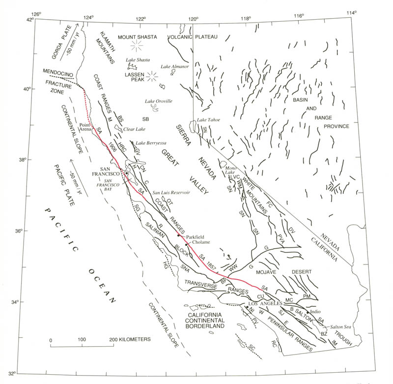
Place names and faults most commonly used in text (see front of book for more complete maps of place names and faults). Faults (dotted where concealed): B, Banning; BP, Big Pine; BS, Bartlett Springs; BZ, Brawley seismic zone; C, Calaveras; CN, Concord; CU, Cucamonga; DV, Death Valley; E, Elsinore; FC, Furnace Creek; G, Garlock; GV, Green Valley; H, Hayward; HG, Hosgri; HRC, Healdsburg-Rodgers Creek; 1M, Imperial; LVC, Long Valley caldera; M, Maacama; MC, Mission Creek; NI, Newport- Inglewood; OT, Ortigalita; PM, Pinto Mountain; PV, Palos Verdes; PV A, Panamint Valley; R, Rinconada; RC, Rose Canyon; SA, San Andreas; SC, San Clemente Island; SG, San Gregorio; SJ, San Jacinto; SN, Sierra Nevada; SNA, Sur-Nacimiento; W, Whittier; WM, White Mountains; WW, White Wolf. Arrows and numbers indicate direction and amount of motion, respectively, of Pacific and Gorda plates with respect to North American plate to the east; red lines indicate 1857 and 1906 ruptures of San Andreas fault |
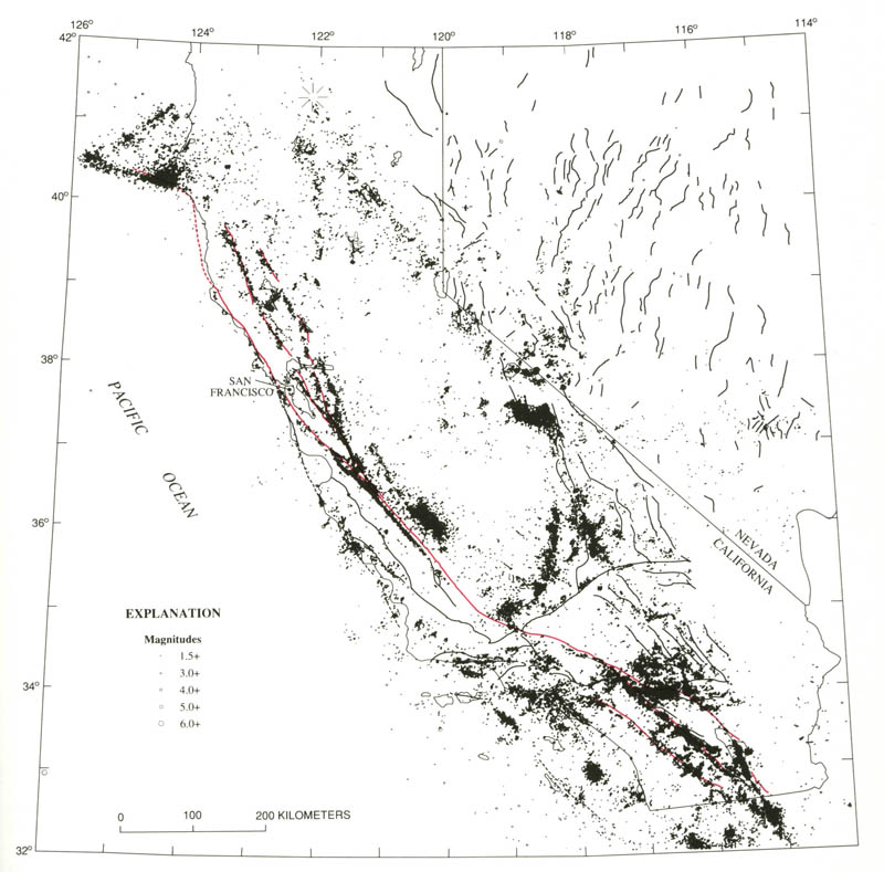
Locations of 64,000 M>1.5 earthquakes in California and western Nevada during 1980-86 and mapped Holocene faults (dotted where concealed; major branches of the San Andreas fault system marked in red). |


Motion between the North American and Pacific plates at the latitude of the San Andreas fault produces a broad zone of large-magnitude earthquake activity extending more than 500 km into the continental interior. The San Andreas fault system defines the western limits of plate interaction and dominates the overall pattern of seismic strain release. Few of the M��6 earthquakes that have occurred in the past 2 centuries were located on the San Andreas fault proper, an observation emphasizing the importance of secondary faults for both seismic-hazard assessment and tectonic processes.
Between Punta Gorda on the northern California coast and the head of the Gulf of California, 1,350 km to the southeast, lies the active transform boundary that forms the modern San Andreas fault system (fig. 6.1). Dextral motion between the North American and Pacific plates along this system is accommodated within an elongate zone, broadening from about 100 km at its north end to about 300 km in southern California. The San Andreas fault proper hugs the east side of this zone at its south terminus and gradually migrates across the zone, lying on the west edge of the zone at its north terminus. The San Andreas fault system transmits about three-fourths of the relative motion across the plate boundary, as shown by various geologic and geodetic evidence. Much of this motion is stored elastically in the upper crust along the major faults in the system, ultimately to be released in large plate-boundary earthquakes
Earthquake activity in California and Nevada at the latitude of the San Andreas fault extends well beyond the confines of the San Andreas system. In the past century alone, only about half of the M> 6 activity has fallen within the San Andreas system; of the rest, half is associated with the western Basin and Range province, and the other half with the Mendocino triple junction and the Gorda plate. Although activity in the latter region reflects the tectonics of the triple junction and the collision of the Gorda plate with the North American plate, seismicity east of the San Andreas system along the east flank of the Sierra Nevada and in the Basin and Range province reflects the incomplete accommodation of plate motion along the San Andreas fault system. A significant proportion of this "missing" motion occurs in the Basin and Range, the seismicity of which plays an integral role in the tectonics of the plate boundary.
THE SEISMIC CYCLE
An important implication of the characteristic-earthquake model is the existence of a repetitive cycle of strain accumulation and release (Fedotov, 1968). Mogi (1981) suggested the existence of definite stages in the cycle, including a low level of seismicity in the first part of the cycle once aftershock of the latest event subside, a rise in regional activity as strain accumulates, and ultimately the occurrence of another earthquake with its attendant fore shocks and aftershocks, which initiates the next cycle.
The long-term seismicity within the San Andreas fault system displays these characteristics along the rupture zone of the great 1906 earthquake (figs. 6.16, 6.17; Ellsworth and others, 1981). Activity was relatively high during the 19th century, as becomes particularly apparent after 1850, when the record is virtually complete. After the great 1906 earthquake, the level of seismicity changed drastically, and moderate events essentially ceased for 50 years. Since the mid-1950''s, the activity level has increased and begun to approach the 19th-century level (Tocher, 1959). This change in activity associated with the 1906 earthquake has been noted many times (for example, Gutenberg and Richter, 1954), and it is an open question whether it represents a premonitory increase (Toppozada and others, 1988) or whether the long quiescent period since 1906 is the essential feature (Ellsworth and others, 1981).
Comparable variations in seismicity appear to be present in southern California, although the historical record there is less reliable until about 1890. Along the rupture zone of the great 1857 earthquake, the available data suggest a similar period of low activity for several decades after the event. Farther south, along the section of the fault that has not ruptured in 3 centuries, the activity level since at least the 1880''s is reminiscent of the activity in the San Francisco Bay region before the 1906 earthquake (fig. 6.18). As a potential long-term indicator of high seismic potential, the seismicity surrounding the dormant southern section of the San Andreas fault agrees with independent estimates of long-term potential derived from paleoseismology
FUTURE USES OF EARTHQUAKE HISTORY
At this stage in our understanding of the San Andreas fault system, seismicity is still best described as a random process over time, with a highly clustered spatial distribution. There are, however, tantalizing hints of underlying regularities, such as those in the characteristic earthquakes at Parkfield, or in the striking changes in seismicity associated with the 1906 earthquake. The next generation of refinements to this history will assuredly make comparable contributions by reducing the uncertainty in earthquake locations and magnitudes. Modern seismologic methods for extracting new information on the mechanisms of earthquakes have already proved practical for many events from the early instrumental period. Systematic treatment of the full instrumental catalog with these methods will provide a new basis for understanding the tectonics of the plate boundary and the mechanics of earthquakes.
Tens of thousands of small earthquakes occur in California each year, reflecting brittle deformation of the margins of the Pacific and North American plates as they grind inexorably past one another along the San Andreas fault system. The deformational patterns revealed by this ongoing earthquake activity provide a wealth of information on the tectonic processes along this major transform boundary that, every few hundred years, culminate in rupture of the San Andreas fault in a great (M=8) earthquake
Earthquake activity along the San Andreas fault system reflects brittle accommodation of the crust to the relative motion along the dextral transform boundary between the Pacific and North American plates (see chap. 3). Great (M≈8) earthquakes along the main branch of the San Andreas fault accommodate most of this relative plate motion. These plate-boundary earthquakes rupture the entire 15- to 20-km thickness of the brittle crust with right-lateral offsets of as much as 10 m extending for several hundred kilometers along the fault trace, and they recur along a given section of the San Andreas fault at intervals of several hundred years (Sieh, 1981; Sieh and Jahns, 1984). The 1857 Fort Tejon earthquake in southern California and the 1906 San Francisco earthquake in northern California are only the two most recent such great events along the San Andreas fault
The smaller, more frequent earthquakes dominates the seismicity within the San Andreas fault system between recurrences of great, plate-boundary events. Although this interevent seismicity contributes only marginally to relative plate motion, it is symptomatic of processes underlying the earthquake cycle. In particular, the wealth of data generated by frequent smaller events provides important clues to the seismotectonic fabric, kinematics, and state of stress within the brittle crust and, ultimately, to the seismogenic processes common to earthquakes of all sizes within the San Andreas fault system. This persistent, interevent seismicity also captures widespread popular interest because it includes most of the felt earthquakes in California (earthquakes of M>3 can be locally felt), and the larger of these interevent earthquakes (M=6-7) can cause extensive damage and loss of life when they strike near major population centers.
We examine here the detailed patterns of earthquake occurrence along the San Andreas fault system recorded by the combined northern and southern California seismograph networks for the 7-yr interval 1980-86. These networks, which had evolved to much their present configuration by mid-1979, enable uniform detection and location of all earthquakes of M>1.5 throughout the San Andreas fault system and of M>2 throughout most of California. The telemetered seismic stations in the combined networks approach 550 in number. Signals from the 300 central and northern California stations are recorded and processed at the U. S. Geological Survey''s (USGS) offices in Menlo Park; signals from the 250 southern California stations are recorded and processed under a joint USGS-California Institute of Technology (Caltech) effort on the Caltech campus in Pasadena. These dense telemetered networks overlie regional seismic networks operated by the University of California, Berkeley, and Caltech that provide records of M>3 earthquakes in northern and southern California, respectively, from the early 1930''s onward (table 5.1; Hileman and others, 1973; Bolt and Miller, 1975).
CONCLUSIONS
The spatial-temporal pattern of earthquake occurrence within the seismogenic crust along the San Andreas fault system is the brittle manifestation of distributed deformation of the lithosphere between the Pacific and North American plates along the San Andreas transform boundary. As we develop a more complete model of the long-term behavior of the seismogenic crust, including relations between great, plate-boundary earthquakes that periodically rupture the principal strand of the San Andreas fault system and the persistent background of small to moderate earthquakes on adjacent structures, our image of the deeper deformation will improve. Together will come a more complete understanding of the processes controlling deformation along the transform boundary and of the earthquake cycle. http://geologycafe.com/california/pp1515/chapter5.html
REGIONAL SEISMICITY AND THE SAN ANDREAS TRANSFORM BOUNDARY
SEISMICITY, 1980-86 (By David P. Hill, Jerry P. Eaton, and Lucile M. Jones)
EARTHQUAKE HISTORY, 1769-1989 (By William L. Ellsworth )
FOCAL MECHANISMS AND TRANSFORM-BOUNDARY KINEMATICS
MENDOCINO TRIPLE JUNCTION