 | Antelope Plain -South Valley Alluvium and Basins - Elk Hills and Southern Valley Terraces |
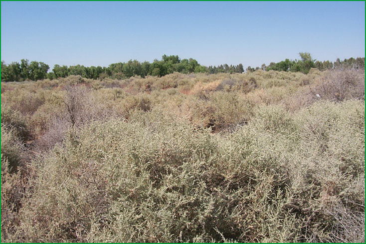
Antelope Plain- Antelope Plain near the town of Lost Hills Scott Miles |
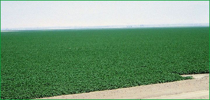
South Valley Alluvium and Basins -west of Bakersfield Scott Miles |
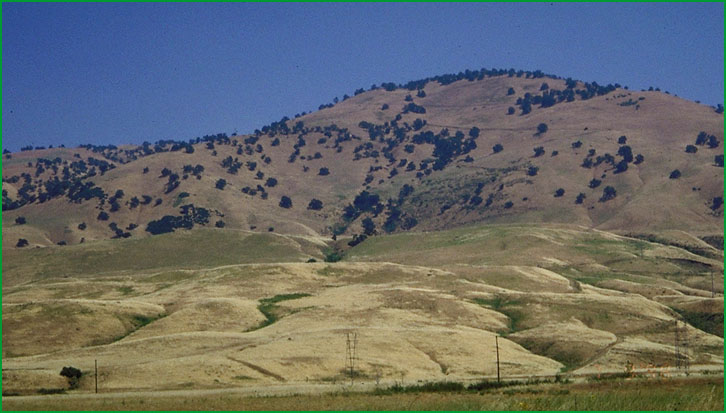
Elk Hills and Southern Valley Terraces - at Grapevine. Subsection M261Fe in background Patsy Miles |
http://www.fs.fed.us/r5/projects/ecoregions/262ax.htm
This subsection is on alluvial fans along the southwestern edge of the San Joaquin Valley. The climate is hot and arid. MLRAs 15f and 17f.
Lithology and Stratigraphy. This subsection contains late Quaternary alluvium. The alluvium is predominantly from sedimentary rocks sources in the Temblor Range of the Coast Ranges.
Geomorphology. This subsection is on nearly level to gently sloping alluvial fans. The subsection elevation range is from 250 to about 1200 feet. Fluvial erosion and deposition are the main geomorphic processes.
Soils. The soils are mostly Typic Torriorthents, and lesser amounts of Typic Natrargids. The soils are well drained. Leaching and accumulation of clay and calcium carbonates in subsoils are the main pedogenic processes, but most of the soils are too young to have argillic and calcic horizons. The soil temperature regimes are thermic. Soil moisture regimes are aridic.
Vegetation. The predominant natural plant communities are Allscale series, and, on floodplains and toe slopes, Greasewood series.
Characteristic series by lifeform include:
Grasslands: Alkali sacaton series, California annual grassland series, Creeping ryegrass series, Saltgrass series.
Shrublands: Allscale series, Arrow weed series, Bladderpod - California ephedra - narrowleaf goldenbush series, Pickleweed series, Shadescale series, Spinescale series.
Climate. The mean annual precipitation is about 5 to 6 inches. It is practically all rain. Mean annual temperature is about 59¯ to 62¯ F. The mean freeze-free period is about 250 to 275 days.
Surface Water. The streams drain from the Coast Ranges toward the basin at the toes of the fans. All streams are small and dry during the summer. There are no lakes
Subsection 262Ay
South Valley Alluvium and Basins
This subsection includes the Buena Vista - Kern Lake Basin, the southern end of the Tulare Basin, and surrounding alluvial fans in the southern San Joaquin Valley. The climate is hot and arid. MLRAs 17f and 17g.
Lithology and Stratigraphy. This subsection contains mostly late Quaternary alluvium and lacustrine sediments, but there are small patches of Pliocene or Pleistocene sediments. The alluvium is from rocks in the Sierra Nevada, the Coast Ranges, and the Transverse Ranges.
Geomorphology. This subsection is in a level basin and on nearly level to gently sloping alluvial fans surrounding the basin on three sides. The northern part is in the Tulare Basin. The subsection elevation range is from 220 to about 1200 feet. Fluvial and lacustrine processes predominate.
Soils. The soils are mostly Typic Torriorthents on alluvial fans, Torriorthents and Typic Natrargids on lake beds, Typic and Vertic Torriorthents and Typic Natrargids on basin-fill around the lake beds, and Typic Haplargids on remnants of old terraces. The soils are well drained. Any soils that were once poorly drained have been drained by diverting and pumping water. The soil temperature regimes are thermic. Soil moisture regimes are aridic.
Vegetation. The predominant natural plant communities are Allscale series on the basin floor and Needlegrass grasslands on alluvial fans. Mesquite series is common in the basin and some Iodine bush series occurs there.
Characteristic series by lifeform include:
Grasslands: Alkali sacaton series, California annual grassland series, Creeping ryegrass series, Purple needlegrass series, Saltgrass series.
Shrublands: Bush seepweed series, Allscale series, Arrow weed series, Iodine bush series, Pickleweed series, Shadescale series, Spinescale series, Winter fat series.
Forests and woodlands: Mesquite series.
Climate. The mean annual precipitation is about 5 to 6 inches; it is practically all rain. Mean annual temperature is about 59¯ to 62¯ F. The mean freeze-free period is about 250 to 300 days.
Surface Water. This subsection is a basin that is a sink for water from the southern ends of the Sierra Nevada and the Coast Ranges and from the Transverse Ranges. Water that flows north from the Kern River goes into the Tulare Basin and water that flows south from the Kern River goes to the Buena Vista - Kern Lake Basin. The latter basin contained Buena Vista Lake, at least periodically, before the Kern River was controlled for irrigation. It wet years water from Buena Vista Lake overflowed into Kern Lake. These lakes are now dry. Streams on the alluvial fans, except the Kern River, are dry most of each year.
Subsection 262Az
Elk Hills and Southern Valley Terraces
This subsection is on dissected terraces and alluvial fans of the Elk Hills, west of the Buena Vista Basin, and foothills of mountains at the southern end of the Great Valley. The climate is hot and semi-arid to subhumid. MLRAs 15g and 17g.
Lithology and Stratigraphy. This subsection contains mostly marine Miocene sedimentary rocks in hills at the south end of the Great Valley, nonmarine Plio-Pleistocene sediments in the Elk Hills, and late Quaternary alluvium.
Geomorphology. This subsection is on moderately steep to steep hills at the south end of the Great Valley, dissected terraces in the Elk Hills, and nearly level to gently sloping alluvial fans. The fans have nearly level to very gently sloping surfaces and, where they are dissected, moderately steep sideslopes. Some of the terrace remnants are small mesas. The subsection elevation range is mostly from 400 to about 3000 feet, but over 4000 feet in places. Fluvial processes predominate, plus mass wasting in the hills at the south end of the Great Valley.
Soils. The soils are mostly Typic Torriorthents on alluvial fans and terraces, plus some Lithic Torriorthents on dissected terrace sideslopes. They are Calcixerollic Xerochrepts, Calcic Haploxerolls, and Typic Argixerolls on hills at the south end of the Central Valley. The soils are well drained. She soil temperature regimes are thermic. Soil moisture regimes are aridic in the Elk Hills and aridic and xeric in hills at the south end of the subsection.
Vegetation. The predominant natural plant communities are Allscale series in the Elk Hills and Needlegrass grasslands in hills at the south end of the subsection.
Characteristic series by lifeform include:
Grasslands: Alkali sacaton series, California annual grassland series, Creeping ryegrass series, Purple needlegrass series, Saltgrass series.
Shrublands: Allscale series, Arrow weed series, Big sagebrush series, Bladderpod - California ephedra - narrowleaf goldenbush series, Pickleweed series, Shadescale series, Spinescale series, Winter fat series.
Climate. The mean annual precipitation is about 5 to 6 inches in the Elk Hills and 6 to 8 inches in hills at the south end of the Central Valley. It is practically all rain in the Elk Hills and mostly rain in hills at the south end of the Central Valley. Mean annual temperature is about 50¯ to 62¯ F. The mean freeze-free period is about 225 to 275 days.
Surface Water. Streams in the subsection drain toward the Buena Vista - Kern Lake basin. They are dry most of each year. There are no lakes in the subsection