 | Crescent City Plain - Northern Franciscan-San Pablo Bay Flats - Wiregrass Ridge - Humboldt Bay Flats and Terraces |
Crescent City Plain -Lake Earl area Ś James R. Nelson |
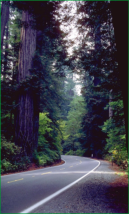
Northern Franciscan - Del Norte Coast Redwood State Park Ś James R. Nelson |
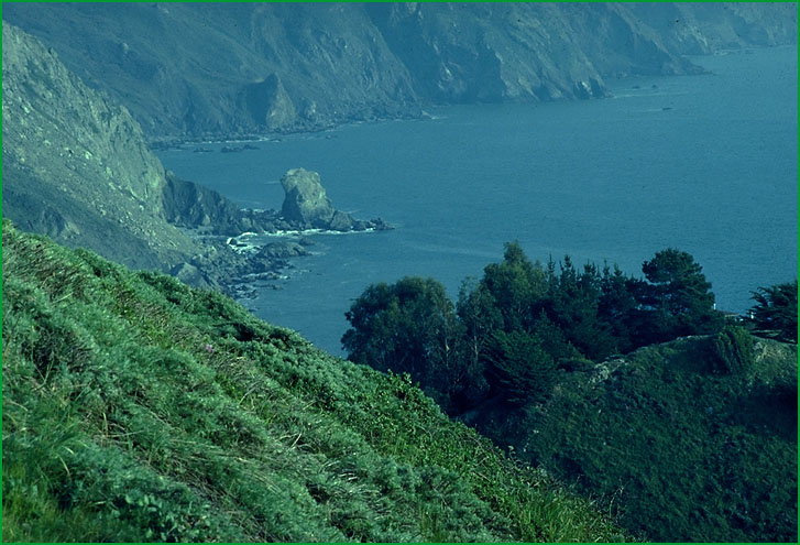
Northern Franciscan - Coastal bluff, scrub Ś James R. Nelson |
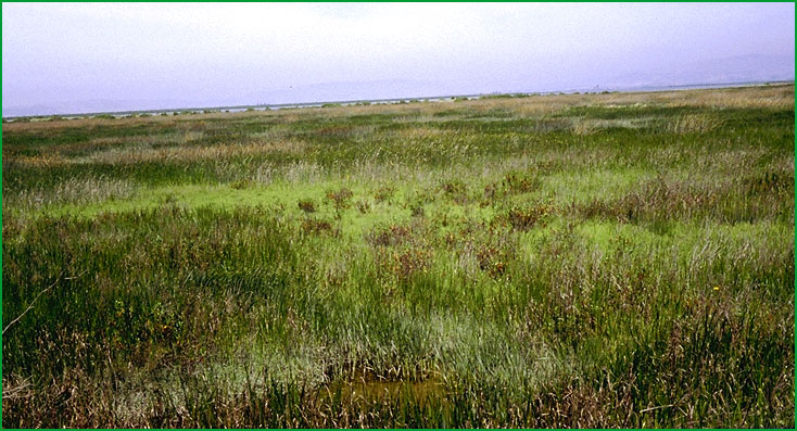
San Pablo Bay Flats -Northwest of Vallejo Ś Charles B. Goudey |
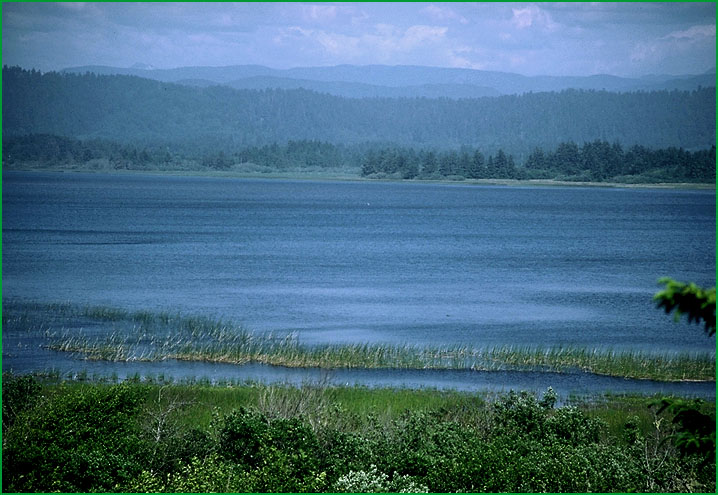
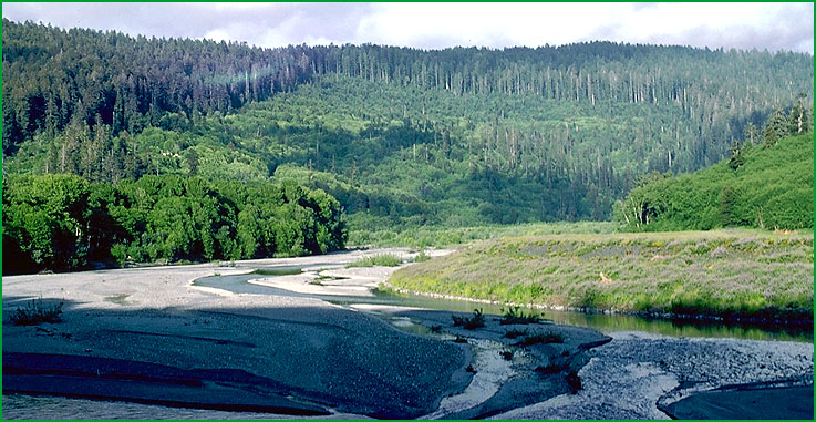
Wiregrass Ridge - near Orick Ś Robert Ettner |
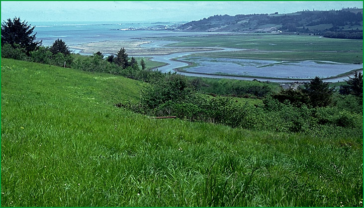
Humboldt Bay Flats and Terraces - Humboldt Bay from Loleta Bluffs Ś Robert Ettner |
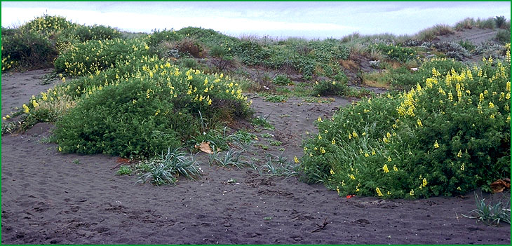
Humboldt Bay Flats and Terraces-Samoa Spit area. Plant is Yellow Bush Lupine (Lupinus arboreus) Ś Julie Nelson |
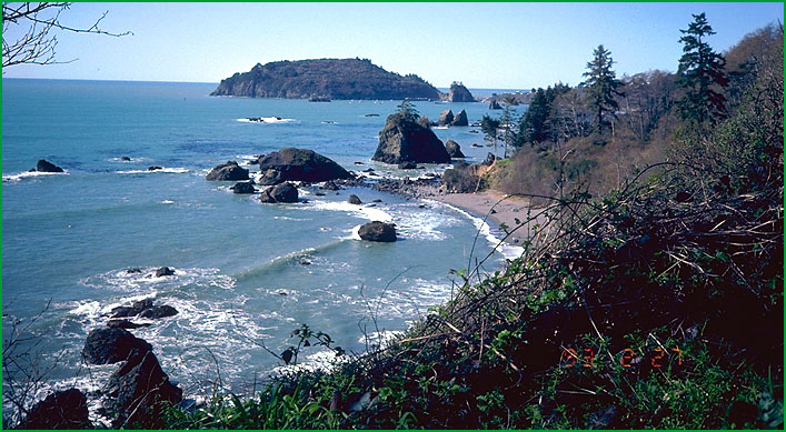
Humboldt Bay Flats and Terraces-Trinidad Head Ś David Howell |
http://www.fs.fed.us/r5/projects/ecoregions/263aa.htm
This subsection is on a coastal plain between mountains of the northern California Coast Ranges and the Pacific Ocean. The mouth of the Smith River, which drains from the Klamath Mountains, is on this coastal plain. It has a temperate, humid climate with much summer fog. MLRA 4b.
Lithology and Stratigraphy. This subsection contains predominantly Quaternary nonmarine and marine sand and clay coastal plain deposits of the Battery formation. Also, there are substantial areas of beach and dune deposits along the ocean shoreline and recent alluvium and Quaternary fluvial terraces along the Smith River.
Geomorphology. This subsection is on a nearly level coastal plain adjacent to the ocean. Beaches line the outer edge of the plain and dunes of sand spread inland from the beaches. Water is ponded on the plain behind the dunes and a large lake occupies much of the plain. The entire plain is less than 200 feet above mean sea-level. Ocean currents, waves, and wind (coastal marine and eolian processes) are active in forming the beaches and dunes. Fluvial and erosion is the main geomorphic processes on the plain behind the beaches and on terraces along the Smith River.
Soils. The soils are mostly Typic Tropohumults and Typic Humitropepts. Udifluvents and Fluvaquents are common soils on recent alluvium. Tropopsamments occur on dunes. The soil temperature regimes are isomesic. Soil moisture regimes are mostly udic, and some aquic.
Vegetation. The predominant natural plant communities on the plain are Sitka spruce series on the outer edge and Redwood series inland. Red alder series is common in riparian areas. The dunes support a succession of plant communities, from bare dune through Native dunegrass series, Sand - verbena - beach bursage series, and Beach pine series to Sitka spruce series. Pickleweed series predominates in saltmarsh.
Characteristic series by lifeform include:
Dune vegetation: Native dunegrass series, European beachgrass series, Sand - verbena - beach bursage series.
Saltmarsh vegetation: Pickleweed series, Saltgrass series.
Grasslands: Introduced perennial grassland series.
Shrublands: Coyote brush series, Salal - California huckleberry series.
Forests and woodlands: Beach pine series, Red alder series, Redwood series, Sitka spruce series.
Climate. The mean annual precipitation is about 60 to 80 inches; there is much summer fog. Mean annual temperature is about 53░ F, and there is less than 14░ F difference between lowest and highest monthly means. The mean freeze-free period is about 300 days.
Surface Water. Water is ponded on the coastal plain to form lakes, with the largest being Lake Earl. The Smith River, a large distributary from the Klamath Mountains, has an outlet on the Plain. Tidal water enters the mouth of the Smith River and may spill over into some of the lakes.
Subsection 263Ab
Northern Franciscan
This subsection is in a steep mountainous area of the northern California Coast Ranges with substantial oceanic influence on climate, including summer fog. It is bounded by the South Fork Mountain Thrust fault and a branch of it on the east, by the Pacific Ocean on the west, and by the Grogan fault on the southwest. The climate is temperate and humid. MLRA 4b.
Lithology and Stratigraphy. This subsection is dominated by Jurassic and Cretaceous Franciscan sedimentary, minor volcanic, and metamorphic rocks of the Eastern Belt. They are intensely folded and faulted. Plio-Pleistocene marine and nonmarine sediments are the predominant strata between the Lost Man fault and the ocean, south of the mouth of the Klamath River. There are small areas of recent alluvium along the Klamath and Smith Rivers and Pleistocene gravels on mountain ridges between the Klamath River and the Lost Man fault.
Geomorphology. This is a subsection of mountains with rounded ridges, steep and moderately steep sides, and narrow canyons. Most of the mountains are elongated in north-northwest to northwest directions and have subequal summits with increasing elevation toward the interior. Plio-Pleistocene sediments southwest of the Lost Man fault have been elevated nearly 1000 feet above sea-level and highly dissected. The subsection elevation range is from sea-level up to 3092 feet on School House Peak. Mass wasting and fluvial erosion are the main geomorphic processes. The density (area/area) of landslides is very high.
Soils. The soils are mostly Typic Humitropepts and Mollic Hapludalfs. Typic Tropohumults and Ultic Hapludalfs are the common soils on Plio-Pleistocene sediments. Typic Tropofluvents and Cumulic Humaquepts occur in alluvium along the major streams. Most of the soils are leached free of carbonates and the older ones are strongly acid. The soil temperature regimes are predominantly isomesic. Soil moisture regimes are mostly udic with some aquic.
Vegetation. The predominant natural plant community is Redwood series. Douglas-fir - tanoak series occurs on upper slopes and ridges. Sitka spruce occurs along the coast. There are patches of Black oak series, Oregon white oak series, and Pacific reedgrass series on south-facing slopes and ridges. Red alder series is common in riparian areas.
Characteristic series by lifeform include:
Grasslands: Introduced perennial grassland series, Pacific reedgrass series.
Saltmarsh vegetation: Pickleweed series, Saltgrass series.
Shrublands: Salal - California huckleberry series.
Forests and woodlands: Black oak series, California bay series, Douglas-fir - tanoak series, Grand fir series, Red alder series, Redwood series, Sitka spruce series, Tanoak series, Western hemlock series.
Climate. The mean annual precipitation is about 60 to 120 inches. Most is rain at lower elevations and some is snow at higher elevations. Mean annual temperature is about 45░ to 53░ F. The mean freeze-free period is about 250 to 300 days.
Surface Water. Runoff is rapid and many of the smaller streams are dry by the end of the summer. The Klamath and Smith Rivers, which drain from the Klamath Mountains, cross this subsection to reach the ocean. Natural lakes are absent, other than minor and temporary ponding by landslides
Subsection 263Ac
San Pablo Bay Flats
This subsection is on parts of the plain north and west of San Pablo Bay that are less than 10 feet above mean sea level. The climate is temperate and subhumid. MLRA 14d.
Lithology and Stratigraphy. This subsection contains Quaternary bay-fill, largely silt and clay.
Geomorphology. This subsection is on a tidal flat. The entire subsection is less than 10 feet above mean sea-level. The main geomorphic processes are coastal marine, and, on the inner edges of the subsection, fluvial.
Soils. The soils are mostly Sulfic Fluvaquents and Endoaquepts, Typic Hydraquents, and Haplaquepts. The soil temperature regimes are isomesic. Soil moisture regimes are aquic.
Vegetation. The predominant natural plant community is Pickleweed series. Saltgrass series is prevalent around the inland margin of the salt marsh. Sedge meadow communities and Emergent aquatic communities are prevalent on the inner edges of the subsection, away from the bay.
Characteristic series by lifeform include:
Grasslands: California annual grassland series, Introduced perennial grassland series.
Saltmarsh vegetation: Cordgrass series, Ditch-grass series, Pickleweed series, Saltgrass series.
Freshwater marshes: Bulrush series, Bulrush - cattail series, Cattail series, Duckweed series, Mosquito fern series, Sedge series.
Climate. The mean annual precipitation is about 20 to 30 inches. There is some summer fog. Mean annual temperature is about 56░ to 58░F. The mean freeze-free period is about 250 to 275 days.
Surface Water. High tides inundate most of the area. During winter, fresh water flows onto the flats. Deltas of the Napa River and Sonoma, Petaluma, and Novato Creeks are in this subsection
Subsection 263Ad
Wiregrass Ridge
This subsection is a steep mountainous area south-southeast of Orick. It is a narrow strip bounded on the east-northeast by the Grogan fault, which is along Redwood Creek, and on the west-southwest by the Bald Mountain fault. It has a temperate, humid climate. There is substantial oceanic influence on climate, including summer fog. MLRA 4b.
Lithology and Stratigraphy. This subsection is dominated by Jurassic and Cretaceous Franciscan sedimentary, minor volcanic, and metamorphic rocks, including the schist of Redwood Creek. They are intensely folded and faulted of the Eastern Belt. There are small areas of recent alluvium along Prairie and Redwood Creeks.
Geomorphology. This is a subsection of mountains with rounded ridges, steep and moderately steep sides, and narrow canyons. Most of the mountains are elongated in north-northwest to northwest directions and have subequal summits with increasing elevation toward the interior. The valleys of Prairie and Redwood Creeks are broad enough near their mouths to contain appreciable floodplain. The subsection elevation range is from sea-level up to 4637 feet on Mt. Andy. Mass wasting and fluvial erosion are the main geomorphic processes.
Soils. The soils are mostly Typic Humitropepts and less extensive Orthoxic Tropohumults. The soils are leached free of carbonates and the older ones are strongly acid. The soil temperature regimes are predominantly isomesic. Soil moisture regimes are mostly udic.
Vegetation. The predominant natural plant community is Redwood series. Red alder series is common in riparian areas.
Characteristic series by lifeform include:
Grasslands: Introduced perennial grassland series, Pacific reedgrass series.
Shrublands: Coyote brush series, Salal - California huckleberry series.
Forests and woodlands: Black oak series, Red alder series, Redwood series, Tanoak series, Western hemlock series.
Climate. The mean annual precipitation is about 60 to 80 inches. Most is rain at lower elevations and some is snow at higher elevations. Mean annual temperature is about 40░ to 53░ F. The mean freeze-free period is about 225 to 300 days.
Surface Water. Runoff is rapid and many of the smaller streams are dry by the end of the summer. Natural lakes are absent. Brackish water lagoons are common along the coast
Subsection 263Ae
Humboldt Bay Flats and Terraces
This subsection is on a coastal plain and terraces between mountains of the northern California Coast Ranges and the Pacific Ocean. The mouths of the Mad, Van Duzen, and Eel Rivers, which drain much of the northern California Coast Ranges, are on this coastal plain. The subsection climate is temperate and humid. There is substantial oceanic influence on climate, including summer fog. MLRA 4b.
Lithology and Stratigraphy. This subsection is predominantly Quaternary nonmarine and marine terrace deposits and recent alluvium. Also, there are some Plio-Pleistocene nonmarine sediments and, along the ocean shoreline, substantial areas of beach and dune deposits.
Geomorphology. This subsection is on a low coastal plain and marine terraces adjacent to the ocean. Beaches line the outer edge of the plain and dunes of sand spread inland from the beaches. There is a large bay behind this shoreline that has a permanent outlet to the ocean. The Quaternary terraces are only slightly dissected, but the Plio-Pleistocene sediments are highly dissected. They reach elevations up to about 1000 feet. Ocean currents, waves, and wind are active to forming the beaches and dunes. Fluvial erosion and deposition are the main geomorphic processes on the plain and terraces behind the beaches.
Soils. The soils on terraces are mostly Typic Humitropepts and Typic Tropohumults. Tropofluvents, Fluvaquents, and Humaquepts are common soils on recent alluvium. Tropopsamments occur on the dunes. The soil temperature regimes are isomesic and mesic. Soil moisture regimes are mostly udic, and some aquic.
Vegetation. The predominant natural plant communities on the plain and on marine terraces around Trinidad Head and Patricks Point are Sitka spruce series on the outer edge and Redwood series inland. Much of the area has successional cover of shrubs or Red alder series. The dunes support a succession of plant communities, from bare dune through Native dunegrass series, Sand - verbena - beach bursage series, and Beach pine series or Bishop pine series to Sitka spruce series. Pickleweed series is present, but not extensive, in this subsection.
Characteristic series by lifeform include:
Dune vegetation: Native dunegrass series, European beachgrass series, Sand - verbena - beach bursage series.
Saltmarsh vegetation: Cordgrass series, Ditch-grass series, Pickleweed series, Saltgrass series.
Grasslands: Introduced perennial grassland series, Pacific reedgrass series.
Shrublands: Coyote brush series, Salal - California huckleberry series.
Forests and woodlands: Beach pine series, Bishop pine series, Red alder series, Sitka spruce series.
Climate. The mean annual precipitation is about 30 to 50 inches. There is summer fog. Mean annual temperature is about 50░ to 53░ F, and there is less than 12░ F difference between lowest and highest monthly means. The mean freeze-free period is about 300 days.
Surface Water. Water runs off of the terraces rapidly, but there are large areas of floodplain along the Eel, Van Duzen, and Mad Rivers. Tidal water enters Humboldt Bay and the mouths of the Mad and Eel Rivers. Brackish water lagoons are common along the coast.