 | Ivanpah Valley -Providence Mountains - Lanfair Valley -Bullion Mountains - Bristol Lake |
Ivanpah Valley area near Nipton Ś Charles B. Goudey |
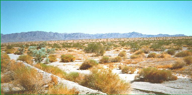
near Needles Ś Matthew Miles |
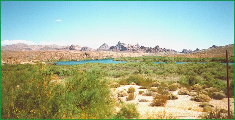
Colorado River area Ś Matthew Miles |
near Twenty Nine Palms Ś John C. Rule |
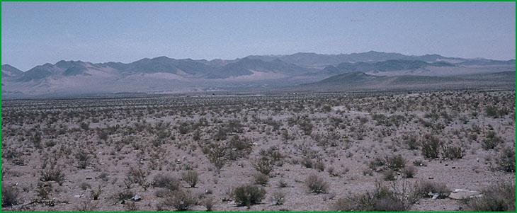
looking south from Mannix area. 322Ah in foreground Ś Charles B. Goudey |
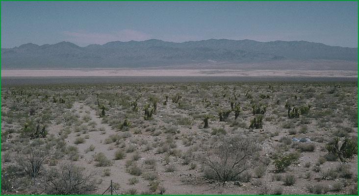
This subsection is the alluvial plain of Ivanpah Valley. There are a few moderately steep hills protruding through the alluvial plain. It has a hot arid climate. MLRA 30g.
Lithology and Stratigraphy. This subsection contains mainly Quaternary fluvial, lacustrine, and eolian sand deposits. Hills protruding through the alluvial plain are mainly Precambrian metamorphic rocks.
Geomorphology. This subsection is mainly on very gently to moderately sloping alluvial fans, nearly level basin floor and dry lake bed. Ivanpah Valley is oriented toward the north-northeast. Alluvial fans slope up to about 18%, but only the upper parts of them have slopes >12 or 15%. There are large playas on the lake beds. The elevation range is about 2600 to 4500 feet. Fluvial erosion and deposition, and eolian deflation and deposition are the main geomorphic processes.
Soils. The soils are mostly Typic subgroups of Torrifluvents, Torripsamments, and Torriorthents and Calciorthids. There are shallow Typic Paleorthids on old fans. Soils on hills are mostly Lithic Torriorthents and Lithic Camborthids. The soils are well drained, except on poorly drained playas. Soil temperature regimes are thermic; and soil moisture regimes are aridic.
Vegetation. The predominant natural plant community is Creosote bush series. Joshua tree series is common on alluvial plains. Mixed saltbush series is common on basin floor and Iodine bush series and Saltgrass series are present on wet basin-fill and lacustrine deposits. Greasewood series occurs in riparian areas and around saltmarsh.
Characteristic series by lifeform include:
Grasslands: Alkali sacaton series, Big galleta series, Desert sand - verbena series, Indian ricegrass series, Saltgrass series.
Shrublands: Brittlebrush series, Creosote bush series, Creosote bush - white bursage series, Desert-holly series, Fourwing saltbrush series, Greasewood series, Iodine bush series, Joshua tree series, Mixed saltbush series, Scadscale series, White bursage series, Winter fat series.
Forests and woodlands: Mesquite series.
Climate. The mean annual precipitation is about 4 to 7 inches. It is mostly rain. Mean annual temperature is about 50░ to 64░ F. The mean freeze-free period is about 200 to 250 days.
Surface Water. Runoff is rapid from mountains and alluvial fans and slow from basin-fill. All drainage is internal, mostly to closed basins in Ivanpah Valley, but the southern end drains through Kelso Wash to Silurian Valley. Streams are dry most of each year. There is temporary ponding on playas, or dry lake beds.
Subsection 322Al
Providence Mountains - Lanfair Valley
This subsection includes Lanfair Valley, the mountains surrounding it, the upper part of Fenner Valley, the mountains on the east and west sides of Fenner Valley, Granite Mountain, and Bristol Mountain. The subsection is about half upland and half alluvial plain. It has a hot arid climate that is moderated by elevation on the higher mountains. MLRAs 29f and 30g.
Lithology and Stratigraphy. The uplands in this subsection are mainly Mesozoic granitic, Tertiary volcanic, Paleozoic marine sedimentary, Pre-Cretaceous granitic and metamorphic, and Precambrian metamorphic rocks. The alluvial plains are mostly Quaternary fluvial deposits, but some Pliocene and possibly earlier Tertiary deposits. There is a small area of lacustrine deposits on the east side of Lanfair Valley.
Geomorphology. This subsection is on steep to very steep mountains, gently to moderately sloping pediments and alluvial fans, and nearly level basin floor. The mountains and ridges are oriented north-south or toward the north-northwest, except Granite Mountain and mountains southwest of Granite Mountain. Mountains on the east and west sides of Fenner and Lanfair Valleys converge at the north end of Lanfair Valley. Lanfair and Fenner Valleys are separated by Hackberry Mountain and hills in an east-west row. Bristol, Old Dad, and Marble Mountains southwest of Granite Mountains have a northwest trend. Granite Mountains have a transitional trend, between this northwest trend and the north-northeast trend of Providence Mountains. The elevation range is from about 1000 feet in Fenner Valley up to 5340 feet in the Old Woman Mountains, 6790 feet in the Granite Mountains, 6608 feet in the Providence Mountains, and 7540 feet in the New York Mountains. Mass wasting and fluvial erosion and deposition are the main geomorphic processes.
Soils. The upland soils are mostly Lithic Torriorthents and Lithic Camborthids, plus Lithic Haplargids on volcanic rocks. At higher elevations, the upland soils are Lithic Xeric Torriorthents, shallow Xeric Torriorthents, and shallow Xeric Haplargids. Soils on alluvial plains are mostly Typic Torriorthents and Typic Torripsamments on younger fans and Typic Camborthids and Typic Haplargids on older noncarbonatic and Typic Calciorthids and shallow Typic Paleorthids on older carbonatic fans. The soils are well drained. The soil temperature regimes are mostly thermic, but mesic at higher elevations. Soil moisture regimes are aridic.
Vegetation. The predominant natural plant communities are Creosote bush series on fans and lower mountain slopes, Singleleaf pinyon series on higher mountain slopes, and White fir series on the highest mountains. Joshua tree series is common on alluvial plains. Black bush series occurs on mountain slopes.
Characteristic series by lifeform include:
Grasslands: Alkali sacaton series, Big galleta series, Indian ricegrass series, Saltgrass series.
Shrublands: Big sagebrush series, Bitterbrush series, Black bush series, Black sagebrush series, Catclaw acacia series, Creosote bush series, Creosote bush - white bursage series, Desert-holly series, Fourwing saltbrush series, Greasewood series, Hop-sage series, Iodine bush series, Joshua tree series, Mixed saltbush series, Mojave yucca series, Nolina series, Scalebroom series, Scadscale series, Teddy-bear cholla series, White bursage series.
Forests and woodlands: Mesquite series, Singleleaf pinyon series, Singleleaf pinyon - Utah juniper series, Twoleaf pinyon stands, Utah juniper series, White fir series.
Climate. The mean annual precipitation is about 4 to 10 inches. It is mostly rain, but snow at higher elevations. Mean annual temperature is about 45░ to 72░ F. The mean freeze-free period is about 175 to 300 days.
Surface Water. Runoff is rapid from mountains and alluvial fans and slow from basin-fill. Most of the runoff drains to closed basin around the subsection. Some runoff from Lanfair Valley and upper Fenner Valley is through the Piute Mountains to Piute Valley on the east, but more is south through Fenner Valley to Cadiz Valley. Streams are dry most of each year; water flows in few of them except following intense rain.
Subsection 322Am
Piute Valley - Sacramento Mountains
This subsection includes Piute Valley, Dead Mountains, upper part of Ward Valley, Sacramento Mountains, Chemehuevi Valley, Whipple Mountains, and Turtle Mountains. The subsection is about half upland and half alluvial plain. It has a hot to very hot arid climate that is moderated by elevation on the higher mountains. MLRAs 29f and 30g.
Lithology and Stratigraphy. The uplands in this subsection are mainly Mesozoic granitic, Tertiary volcanic, and Precambrian granitic and metamorphic rocks. The alluvial plains are mostly Quaternary fluvial deposits, but some Pliocene and possibly earlier nonmarine Tertiary deposits. There are small areas of lacustrine deposits.
Geomorphology. This subsection is on steep to very steep mountains, gently to moderately sloping pediments and alluvial fans, and nearly level basin floor. Tertiary sediments are generally eroded to ōbadlandsö. Dead Mountain, Piute Valley, and Ward Valley are aligned north-south. Sacramento Mountains and Turtle Mountains are oriented toward the northwest, but the Turtle Mountains are turned toward the north at the northern end, parallel to Ward Valley. Whipple Mountains and Chemehuevi Valley arc from a east-northeast trend around to a northwest trend parallel to and between the Turtle and Sacramento Mountains. The elevation range is from 450 feet along the Colorado River to about 3000 feet in the Sacramento Mountains, about 4000 feet in the Whipple Mountains, and up to 5866 feet on Horn Peak in the Turtle Mountains. Mass wasting and fluvial erosion and deposition are the main geomorphic processes.
Soils. The upland soils are mostly Lithic Torriorthents and Lithic Camborthids, plus Lithic Haplargids on volcanic rocks. Soils on alluvial plains are mostly Typic Torriorthents and Typic Torripsamments on younger fans and Typic Camborthids and shallow Typic Paleorthids on older fans. The soils are well drained. Soil temperature regimes are thermic in mountains and hyperthermic on most of the alluvial plains, except in Piute Valley. Soil moisture regimes are aridic.
Vegetation. The predominant natural plant communities are Creosote bush series and Creosote bush - white bursage series. Black bush series occurs on higher mountain slopes. Current plant communities include Tamarisk series in riparian areas along the Colorado River.
Characteristic series by lifeform include:
Grasslands: Big galleta series, Indian ricegrass series.
Shrublands: Black bush series, Brittlebrush series, Creosote bush series, Creosote bush - white bursage series, Desert-holly series, Scadscale series, Tamarisk series, Teddybear cholla series, White bursage series.
Climate. The mean annual precipitation is about 5 to 10 inches. It is all rain at lower elevations and mostly rain at higher elevations. Mean annual temperature is about 50░ to 74░ F. The mean freeze-free period is about 200 to 300 days.
Surface Water. Runoff is rapid from mountains and alluvial fans and slow from basin-fill. Most of the runoff drains through Piute Wash, Chemehuevi Valley, or Vidal Valley to the Colorado River, but some drains through Ward Valley to Danby Lake. Streams are dry most of each year; water flows in few of them except following intense rain.
Subsection 322An
Lucerne - Johnson Valleys and Hills
This subsection includes mountains, hills, pediments and alluvial plain north of the San Bernardino and Bighorn Mountains and the Pinto Mountain Fault, from the Mojave River east to the linear depression (subsection 322Ao) that stretches from Troy Lake southeastward to Cadiz Lake and beyond. The area of pediment and alluvial plain is greater than that of mountains and hills. It has a hot, arid climate. MLRAs 29f and 30g.
Lithology and Stratigraphy. The bedrock in this subsection is mainly Mesozoic granitic rocks, compared to mostly volcanic rocks to the east. Also, there is Jurassic - Triassic metavolcanic and Precambrian metamorphic rock and some Mesozoic mafic plutonic and Paleozoic marine sedimentary rock. Transported Quaternary deposits are mostly alluvium, but include lacustrine deposits and eolian sand.
Geomorphology. This section is on steep mountains, moderately steep hills, very gently to moderately sloping pediments and alluvial fans, and nearly level basin floor and dry lake bed. There are ōbadlandsö on eroded Miocene nonmarine sedimentary rocks. The general orientation of the hills is not nearly as clear as that of the major faults, which trend northwest. Some of the larger dry lake beds are, from west to east, Lucerne, Soggy, Melville, Galway, Emerson, and Deadman Lake. The elevation range is from about 1600 feet up to 4873 feet in the Granite Mountains, 5525 feet in the West Ord and 6309 feet in the East Ord Mountains, and 5878 feet in the Rodman Mountains. Mass wasting, fluvial erosion and deposition, and eolian deflation and deposition are the main geomorphic processes.
Soils. The soils are mostly Lithic Torriorthents and Lithic Haplocambids in uplands, and some shallow Xeric Torriorthents and shallow Xeric Haplargids in areas with mesic soil temperature regimes. Typic Haplargids are common on volcanic rocks and on north-facing slopes in granitic terrain. Soils on younger fans and basin-fill are mostly Typic Torrifluvents, Typic Torripsamments, and Typic Torriorthents. Soils on older fans are mostly Durinodic Haplocalcids and Durinodic Calciargids. The soils are well drained, except on poorly drained playas. There are Salorthids on poorly drained playas lacking vascular plants. Soil temperature regimes are mostly thermic, and mesic on the higher mountains. Soil moisture regimes are aridic.
Vegetation. The predominant natural plant community is Creosote bush series, and Big galleta series is common. Joshua tree series is common on pediments and fans and Indian ricegrass series occurs on eolian sand. California juniper series predominates above about 3000 feet near the San Andreas Fault. Black bush series occurs on the higher mountains. Mixed saltbush series is common on basin floor and Iodine bush series and Saltgrass series are present on wet basin-fill and lacustrine deposits.
Characteristic series by lifeform include:
Grasslands: Alkali sacaton series, Big galleta series, Desert needlegrass series, Desert sand - verbena series, Indian ricegrass series, Saltgrass series.
Shrublands: Allscale series, Black bush series, Brittlebrush series, California buckwheat series, Catclaw acacia series, Creosote bush series, Creosote bush - white bursage series, Desert-holly series, Fourwing saltbrush series, Greasewood series, Hop-sage series, Iodine bush series, Joshua tree series, Mixed saltbush series, Mojave yucca series, Rubber rabbitbrush series, Scalebroom series, Scadscale series, Spinescale series, White bursage series, Winter fat series.
Forests and woodlands: California juniper series, California sycamore series, Mesquite series.
Climate. The mean annual precipitation is about 4 to 8 inches. It is mostly rain. Mean annual temperature is about 50░ to 68░ F. The mean freeze-free period is about 200 to 275 days.
Surface Water. Runoff is rapid from mountains and alluvial fans and slow from basin-fill. All drainage is internal, to closed basins in the Mojave Desert. Streams are dry most of each year. There is temporary ponding on playas, or dry lake beds.
Subsection 322Ao
Bullion Mountains - Bristol Lake
This subsection includes alluvial fans, basin floor, volcanic flows, and mountains and hills in a linear depression that stretches from Troy Lake southeastward to Bristol Lake and beyond, plus the lower part of Fenner Valley. It has a very hot arid climate. MLRAs 30g and 30h.
Lithology and Stratigraphy. Quaternary alluvial, lacustrine, and eolian deposits and Cenozoic volcanic rocks predominate in this subsection. The volcanic rocks are mostly Miocene andesite and basalt and Quaternary basalt. The mountains are mostly Mesozoic granitic and Pre-Cen