 | Coachella Valley -Borrego Valley - West Mesa |
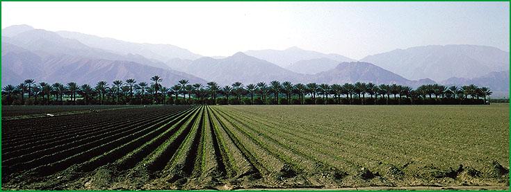
near Coachella Ś Charles B. Goudey |
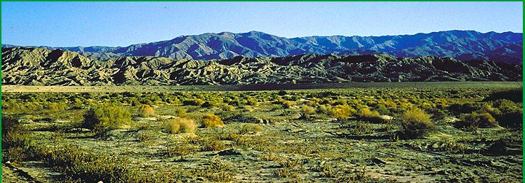
Coachella Valley near Meca Hills Ś Charles B. Goudey |
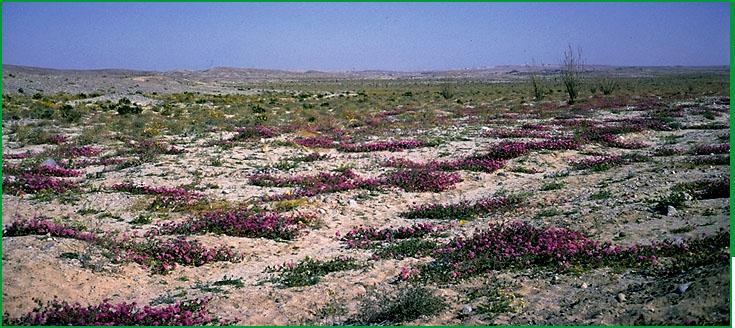
Borrego Valley - West Mesa near Ocotillo Wells Ś Charles B. Goudey |
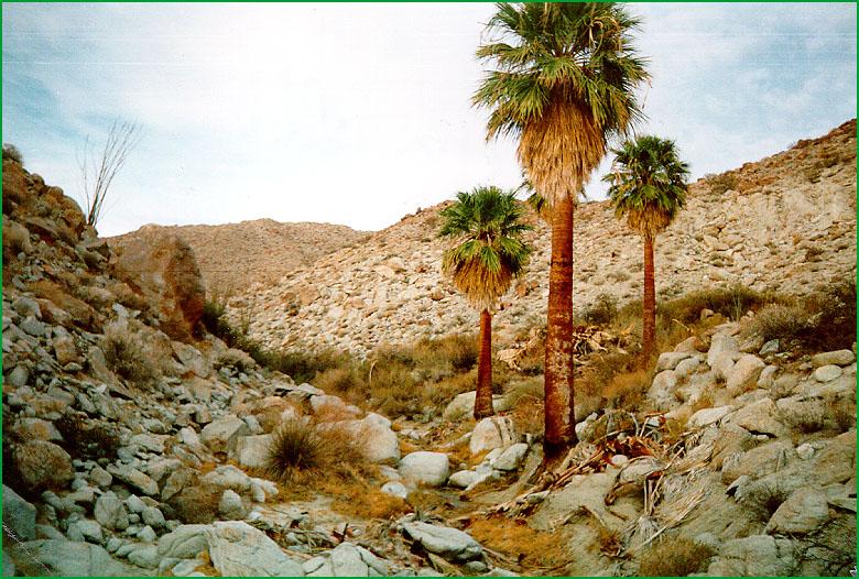
Fan palms in granitic grus on Mt. Palm Springs in the Anza-Borrego Desert State Park Ś Earl Alexander |
http://www.fs.fed.us/r5/projects/ecoregions/322ca.htm
Subsection 322Ca
Coachella Valley
This subsection consists mostly of alluvial fans and lake basin of the Coachella Valley, from San Gorgonio Pass to the Salton Sea. It has a very hot, arid climate. MLRAs 30g, 31g, and 31h.
Lithology and Stratigraphy. Quaternary alluvial, lacustrine, and eolian deposits predominate in this subsection.
Geomorphology. This subsection is mainly on very gently to moderately sloping alluvial fans and nearly level basin floors and dry lake beds. Also, there are some Pliocene and Pleistocene nonmarine sediments that have been eroded and dissected to form ōbadlandsö, as in the Mecca Hills. The Coachella Valley is aligned toward northwest, but it curves around to the west along the Banning Fault; the Banning Fault being the southern branch of the San Andreas Fault, which splits in the Coachella Valley along two paths at the southern edge of the San Bernardino Mountains. The elevation range is from about -230 feet on the shore of the Salton Sea up to 1837 feet in the Mecca Hills and over 2000 feet in San Gorgonio Pass. Fluvial erosion and deposition and eolian deflation and deposition are the main geomorphic processes.
Soils. The soils are mostly Typic Torrifluvents, Typic Torripsamments, and Typic Torriorthents. Coarse-loamy and coarse-silty Typic Torrifluvents predominate in lacustrine sediments and Typic Torripsamments in eolian sand. There are shallow Typic Torriorthents and Typic Calcior-thids in Pliocene and Pleistocene sediments that have been eroded to form ōbadlandsö. The soils are well drained, except on poorly drained playas. The soil temperature regimes are hyperthermic within the subsection, but they are thermic at San Gorgonio Pass. Soil moisture regimes are aridic.
Vegetation. The predominant natural plant communities are Creosote bush - white bursage series and, around the Salton Sea, Allscale series. Fan palm series occurs in many small riparian areas throughout the subsection. Mixed saltbush series and Mesquite series are common on basin floors, and Iodine bush series and Saltgrass series are present on wet basin-fill and lacustrine deposits.
Characteristic series by lifeform include:
Grasslands: Alkali sacaton series, Desert sand - verbena series, Giant reed series, Pickleweed series, Saltgrass series.
Shrublands: Allscale series, Arrow weed series, Bush seepweed series, Catclaw acacia series, Fourwing saltbush series, Iodine bush series, Mixed saltbush series, Scalebroom series.
Forests and woodlands: Fan palm series, Fremont cottonwood series, Mesquite series.
Climate. The mean annual precipitation is about 3 to 4 inches. It is all rain. Mean annual temperature is about 68░ to 75░ F. The mean freeze-free period is about 300 to 350 days.
Surface Water. Runoff is rapid from alluvial fans and slow from basin floor. Drainage is to the Salton Sea through the Whitewater River. Streams have no water in some years and are dry most of each year in other years. There is temporary ponding on playas, or dry lake beds, in some years.
This subsection includes the Clark and Borrego Valleys, West Mesa, and Yuha Desert. They are on the southwest side of the Imperial Valley, between it and the Peninsular Ranges. The subsection has a very hot arid climate. MLRA 30h.
Lithology and Stratigraphy. Quaternary alluvial, lacustrine, and eolian deposits predominate in this subsection. Superstition Mountain, which protrudes through the alluvium on West Mesa, is mostly Mesozoic granitic rock; and Yuha Buttes on the Yuha Desert are Pliocene nonmarine and marine sedimentary rocks.
Geomorphology. This subsection is mainly on very gently to moderately sloping alluvial fans, terraces, and nearly level basin floors and dry lake beds. Also, there are some Pliocene and Pleistocene sediments that have been eroded and dissected to form ōbadlands.ö Clark and Borrego Valleys are aligned toward northwest, along the San Jacinto and Coyote Creek Faults. The elevation range is from about -230 feet on the shore of the Salton Sea up to about 2000 feet. The highest elevation in the Superstition Mountains, which trend toward the northwest, is 760 feet. Fluvial erosion and deposition and eolian deflation and deposition are the main geomorphic processes.
Soils. The soils are mostly Typic Torrifluvents, Typic Torripsamments, and Typic Torriorthents on younger alluvial fans and lacustrine sediments, and Typic Calciorthids and Typic Haplargids on older fans and terraces. There are shallow Typic Torriorthents and Typic Calciorthids on Pliocene and Pleistocene sediments that have been eroded to form ōbadlandsö. Soils on granitic rocks of the rocky Superstition Mountains are Lithic and shallow Typic Torriorthents. The soils are well drained, except on poorly drained playas. The soil temperature regimes are hyperthermic. Soil moisture regimes are aridic.
Vegetation. The predominant natural plant communities are Ocotillo series and Creosote bush - white bursage series and, around the Salton Sea, Allscale series. There are some small areas of Fan palm series in riparian areas. Mixed saltbush series is common on basin floors.
Characteristic series by lifeform include:
Grasslands: Alkali sacaton series, big galleta series, Desert sand - verbena series, Indian ricegrass series.
Shrublands: Allscale series, Arrow weed series, Birchleaf mountain-mahogany - California buckwheat series, Brittlebush series, Brittlebush - white bursage series, California buckwheat series, Catclaw acacia series, Creosote bush series, Creosote bush - white bursage series, Crucifixion-thorn stands, Cupleaf ceanothus - fremontia - oak series, Desert-holly series, Elephant tree stands, Mojave yucca series, Nolina series, Ocotillo series, Teddy-bear cholla series, White bursage series.
Forests and woodlands: Blue palo verde - ironwood - smoke tree series, California sycamore series, Fan palm series, Fremont cottonwood series, Mesquite series.
Climate. The mean annual precipitation is about 3 to 4 inches; it is all rain. Mean annual temperature is about 68░ to 75░ F. The mean freeze-free period is about 300 to 350 days.
Surface Water. Runoff is rapid from alluvial fans and slow from basin floor. Drainage is to the Salton Sea. Streams have no water in some years and are dry most of each year in other years. There is temporary ponding on playas, or dry lake beds, in some years