 | Imperial Valley - East Mesa - Sand Hills |
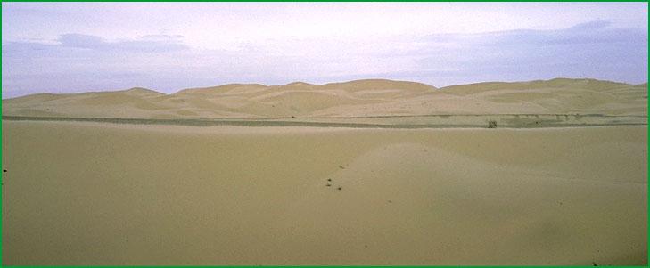
Sand Hills near Gordons Well Ś Charles B. Goudey |
http://www.fs.fed.us/r5/projects/ecoregions/322cc.htm
Subsection 322Cc
Imperial Valley
This subsection is on the lake plain of the Imperial Valley, which is southeast of the Salton Sea. It has a very hot, arid climate. MLRA 30h.
Lithology and Stratigraphy. This subsection contains Quaternary, and some Pliocene, lacustrine deposits. There are a few very small obsidian and pumice domes in a line from Obsidian Butte to Mullet Island at the southeast end of the Salton Sea.
Geomorphology. This subsection is practically all nearly level dry lake bed. The Imperial Valley is aligned toward the northwest. The elevation range is from about -230 feet on the shore of the Salton Sea up to about sea-level on the old shore-line of Lake Cahuilla. Fluvial erosion and deposition and eolian deflation and deposition are the main geomorphic processes.
Soils. The soils are mostly Typic and Vertic Torrifluvents in coarse-loamy, coarse-silty, fine-silty, and fine families. Also, there are some Typic Torripsamments and Typic Torriorthents. The soils are well drained, except on poorly drained playas. The soil temperature regimes are hyperthermic. Soil moisture regimes are aridic.
Vegetation. The predominant natural plant communities are Creosote bush - white bursage series and, around the Salton Sea, Allscale series. Mixed saltbush series and Mesquite series are common in riparian areas, and Iodine bush series and Saltgrass series are present around the margin of the Salton Sea.
Characteristic series by lifeform include:
Grasslands: Alkali sacaton series, Desert sand - verbena series, Indian ricegrass series, Pickleweed series, Saltgrass series.
Shrublands: Allscale series, Arrow weed series, Bush seepweed series, Fourwing saltbush series, Iodine bush series, Mixed saltbush series.
Forests and woodlands: Fremont cottonwood series, Mesquite series.
Climate. The mean annual precipitation is about 3 inches. It is all rain. Mean annual temperature is about 75░ F. The mean freeze-free period is about 350 days.
Surface Water. Runoff is slow. Drainage is to the Salton Sea. The Alamo and New Rivers are the main conduits of overflow from the Colorado River.
Subsection 322Cd
East Mesa - Sand Hills
This subsection includes alluvial fans, sand dunes, the Cargo Muchacho Mountains northeast of the Imperial Valley and the floodplain along the Colorado River. It has a very hot, arid climate. MLRAs 30h and 31g.
Lithology and Stratigraphy. Quaternary alluvial and eolian deposits predominate in this subsection. The Cargo Muchacho Mountains are Mesozoic granitic and Pre-Cretaceous metamorphic rocks, with the former predominating.
Geomorphology. This subsection consists mainly of very gently to moderately sloping alluvial fans, much of them covered by eolian sand, and moderately steep to steep sand dunes. The Cargo Muchacho Mountains and nearby Ogilby Hills are steep to very steep. There is a little pediment around the mountains. Some floodplain of the Colorado River is included in this subsection. The elevation range is from about sea-level to 1200 feet on alluvial fans up to 2221 feet in the Cargo Muchacho Mountains. Fluvial erosion and deposition and eolian deflation and deposition are the main geomorphic processes.
Soils. The soils are mostly Typic Torrifluvents, Typic Torripsamments, and Typic Torriorthents on younger fans, plus Typic Calciorthids and Typic Haplargids on older fans, and shallow Typic Torriorthents where Pleistocene of Pliocene sediments have been eroded to form ōbadlandsö. They are Typic Torripsamments in dune sand. Soils on the rocky Cargo Muchacho Mountains are mostly Lithic Torriorthents. Those on floodplain of the Colorado River are mostly Typic Torrifluvents. The soils are well drained. Soil temperature regimes are hyperthermic, and some are thermic on north-facing slopes at higher elevations. Soil moisture regimes are aridic.
Vegetation. The predominant natural plant communities are Creosote bush series and Creosote bush - white bursage series. Vascular plants are sparse or absent from most of the Algodones Dunes and other sand hills. Fan palm series occurs in some canyons near the Chocolate mountains. Mesquite series occurs in some riparian areas, and Tamarisk series has invaded riparian areas along the Colorado River.
Characteristic series by lifeform include:
Grasslands: Big galleta series, Desert sand - verbena series, Indian ricegrass series.
Shrublands: Catclaw acacia series, Creosote bush series, Creosote bush - white bursage series, White bursage series.
Forests and woodlands: Blue palo verde - ironwood - smoke tree series, Mesquite series.
Climate. The mean annual precipitation is about 3 to 4 inches. It is all rain. Mean annual temperature is about 68░ to 75░ F. The mean freeze-free period is about 300 to 350 days.
Surface Water. Runoff is rapid from most of the area. Drainage is mostly to the Salton Sea, or to the sand hills, where streams disappear, and, from the southeastern edge of the subsection, to the Colorado River. Streams have no water in some years and are dry most of each year in other years. There are no streams in the sand hills.