 | Sweetwater Mountains - Pine Grove Hills- Bodie Hills - Excelsior Mountains-Mono Valley |
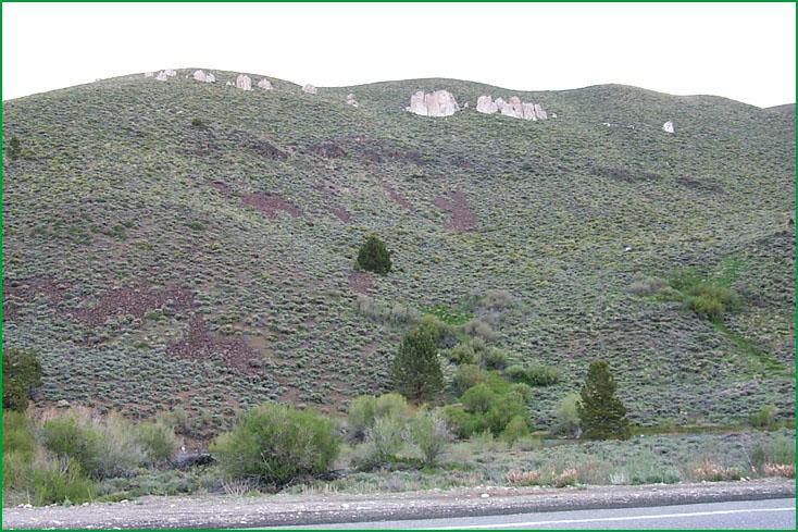
Sweetwater Mountains, Walker River area Ś Scott Miles |
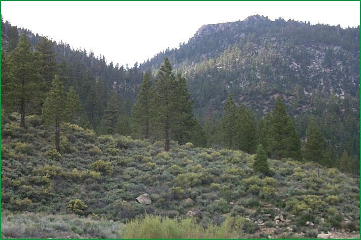
Sweetwater Mountains, Walker River area Ś Scott Miles |
Sweetwater Mountains, Walker River area Ś Scott Miles |
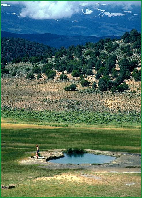
Warm Bodie Hills - Excelsior Mountains -Springs area Ś James R. Nelson |
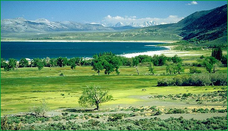
Mono Valley-Mono Lake area looking east toward Powell Mountain Ś Robert Ettner |

http://www.fs.fed.us/r5/projects/ecoregions/341dd.htm
Subsection 341Dd
Sweetwater Mountains - Pine Grove Hills
This subsection includes the Sweetwater Mountains, which are between the West Walker and East Walker Rivers; the Wellington and Pine Grove Hills, which are both contiguous with the Sweetwater Mountains on the northwest and northeast edges of the mountains; and Bridgeport Valley on the upper East Walker River. It has a cold, semi-arid to subhumid climate. MLRA 26f.
Lithology and Stratigraphy. The bedrock is mainly Mesozoic granitic and late Cenozoic volcanic and tuffaceous sedimentary rocks. Much of the volcanic rock is Pliocene basalt and Pliocene or Quaternary andesite. Also, there are Mesozoic granitic and Pre-Cretaceous sedimentary and metamorphic rocks, Quaternary alluvium, and Quaternary glacial till.
Geomorphology. Steep mountains and moderately steep to steep hills predominate in this subsection. Also, there are some gently to moderately sloping pediments and alluvial fans. Glacial moraines and floodplains are present along the West Walker River and in Bridgeport Valley. Most ridges in the subsection are oriented north-south, but a trend is not apparent in some areas of late Cenozoic volcanism that still have topography related to that volcanism. The elevation range is from about 5600 feet up to 9559 feet on Bald Mountain. Mass wasting, volcanism, fluvial erosion and deposition, and freeze-thaw are the main geomorphic processes.
Soils. The soils are mostly shallow Xerollic Haplargids, shallow Aridic Haploxerolls, Aridic Argixerolls, shallow Typic Xeropsamments, and shallow Typic Cryopsamments on granitic rocks. There are shallow Xeric Torriorthents; shallow Xerollic Haplargids; Lithic Xerollic Haplargids; Lithic Ultic and Aridic Haploxerolls; Lithic Ultic, Aridic, Typic, and Pachic Argixerolls; Typic Durixerolls; and Pachic Cryoborolls on other kinds of rocks. Aridic Argixerolls and shallow Abruptic Xerollic Durargids are common on alluvial fans. Soils on moraines are mostly Typic Haploxerolls and Ultic Haploxeralfs. There are Typic Haplaquolls and Aquic Argixerolls on floodplains and basin floors. The soils are well drained, except for somewhat poorly to poorly drained soils on floodplains and basin floors. Soil temperature regimes are mostly frigid, and cryic at higher elevations. Soil moisture regimes are aridic, xeric, and aquic.
Vegetation. The predominant natural plant communities are mostly Big sagebrush series, much Singleleaf pinyon series, and some Curlleaf mountain-mahogany series. Jeffrey pine series and Limber pine series occur on higher mountain slopes, and Low sagebrush series on shallow soils. Sedge meadow alliances occur on floodplains and basin floors.
Characteristic series by lifeform include:
Grasslands: Alpine habitat, Ashy ryegrass series, Breaked sedge series, Creeping ryegrass series, Indian ricegrass series, Nebraska sedge series, Needle-and-thread series, Rocky Mountain series, Short sedge series, Tufted hairgrass series.
Shrublands: Big sagebrush series, Bitterbrush series, Low sagebrush series, Parry rabbitbrush series, Rubber rabbitbrush series.
Forests and woodlands: Curlleaf mountain-mahogany series, Jeffrey pine series, Limber pine series Singleleaf pinyon series, Singleleaf pinyon - Utah juniper series, Utah juniper series.
Climate. The mean annual precipitation is about 10 to 30 inches. Much of the precipitation is snow. Mean annual temperature is about 35░ to 45░ F. The mean freeze-free period is in the range from 50 to 100 days.
Surface Water. Runoff is rapid in mountains, hills, pediments, and fans and slow from floodplains and basin floors. It drains to the Walker River. Streams from the Sierra Nevada are permanent, but those originating in the mountains of this subsection are dry much of each year. There are some closed depressions in volcanic terrain, but they are generally dry.
Subsection 341De
Bodie Hills - Excelsior Mountains
This subsection includes the Excelsior Mountains; the Bodie, Anchorite, and Adobe Hills; and the Alkali and Huntoon Valleys. These hills and valleys are north and east of Mono lake. The climate is cold and semi-arid. MLRA 26f.
Lithology and Stratigraphy. Pliocene and some Quaternary basalt and more silicic volcanic rocks predominate in this subsection. There is some granitic and no other kinds of rock, except in the Excelsior Mountains. In those mountains there are upper Paleozoic and lower Mesozoic volcanic and sedimentary, Mesozoic granitic, and Tertiary volcanic rocks. Quaternary alluvium fills Alkali and Huntoon Valleys.
Geomorphology. The landforms are mostly moderately steep to steep hills, steep mountains, and gently to moderately sloping volcanic flows. The elevation range is from about 5200 feet up to 10,235 feet at Potato Peak on Bodie Mountain. Volcanic craters and cones are common in the hills. The hills lack definite elongation and orientation, except Anchorite Hills which are aligned toward the north-northeast. The Excelsior Mountains are elongated and have three segments aligned north-northeast, northeast, and east-northeast. Mass wasting, volcanism, fluvial erosion and deposition, and freeze-thaw are the main geomorphic processes.
Soils. The soils on volcanic rocks are mostly Lithic Mollic Haploxeralfs, Lithic and Typic Argixerolls, shallow Xerollic Durargids, Abruptic Durixeralfs, Mollic Palexeralfs, and Typic, Vitrandic, and Argic Cryoborolls. Soils in the Excelsior Mountains are mostly Lithic and Typic Xerorthents, Lithic and Typic Xeropsamments, Mollic Camborthids, Mollic Haplargids, and Mollic Durorthids. The soils are well drained. Soil temperature regimes are mostly frigid, and cryic at higher elevations. Soil moisture regimes are aridic and xeric (nearly aridic).
Vegetation. The predominant natural plant communities are Big sagebrush series, Singleleaf pinyon series, and Utah juniper series. Low sagebrush series occurs on shallow soils.
Characteristic series by lifeform include:
Grasslands: Indian ricegrass series, Needle-and-thread series.
Shrublands: Big sagebrush series, Bitterbrush series, Low sagebrush series, Rubber rabbitbrush series.
Forests and woodlands: Singleleaf pinyon series, Singleleaf pinyon - Utah juniper series, Utah juniper series.
Climate. The mean annual precipitation is about 12 to 25 inches. Much of the precipitation is snow. Mean annual temperature is about 32░ to 48░ F. The mean freeze-free period is in the range from 25 to 100 days.
Surface Water. Runoff is rapid. Most of it drains to Mono Lake on the southwest or to Walker Lake. Huntoon Valley is in the bottom of a closed basin. Streams are dry most of each year. There are some closed depression in volcanic terrain, but they are generally dry.
Subsection 341Df
Mono Valley
This subsection consists of the lake plain around Mono Lake, which is at the base of the steep eastern slope of the Sierra Nevada. It has a temperate, semi-arid climate. MLRA 26f.
Lithology and Stratigraphy. Pleistocene and recent lacustrine deposits predominate in this subsection. There is some recent andesite and pyroclastics from volcanoes on Paoha and Negit Islands in Mono Lake and at Black Point on the north shore of the lake.
Geomorphology. The landform is mostly nearly level to gently sloping lake plain. Mono Valley is slightly elongated toward the northeast. The lake plain slopes southwest, so Mono Lake is at the southwest end of the valley. A sequence of several old beach ridges is evident on the northeast side of the valley. The elevation range is from about 6400 feet at the present lake level up to 7180 feet at the highest Pleistocene lake level. The present lake is saline and alkaline, containing about 6% salt. Tufa mounds are prominent features around the lake. Lacustrine deposition and volcanism are the main geomorphic processes.
Soils. The soils are mostly Xeric Torripsamments and Torriorthents, Haploxerollic Durorthids, and Xerollic Haplargids. There are also shallow Xerollic Durargids and Abruptic Durixeralfs on volcanic rocks. The soils are well drained. Soil temperature regimes are mesic; and soil moisture regimes are aridic.
Vegetation. The predominant natural plant communities are Big sagebrush series and some Singleleaf pinyon series and Bitterbrush series. Greasewood series occurs in seep areas.
Characteristic series by lifeform include:
Grasslands: Alkali sacaton series, Ashy ryegrass series, Creeping ryegrass series, Indian ricegrass series, Needle-and-thread series, Saltgrass series.
Shrublands: Allscale series, Bush seepweed series, Mixed saltbush series, Rubber rabbitbrush series, Shadscale series.
Forests and woodlands: Singleleaf pinyon series.
Climate. The mean annual precipitation is about 12 to 15 inches. Much of the precipitation is snow. Mean annual temperature is about 48░ to 50░ F. The mean freeze-free period is in the range from 100 to 150 days.
Surface Water. Mono Lake is in a closed basin that was occupied by Pleistocene Lake Russell. The maximum height of the lake, 7810 feet, was controlled by overflow into Adobe Valley. Much water from Sierra Nevada streams which flow to Mono Lake has been diverted for municipal use, lowering the lake level. Recent regulation of water diversion has halted the decline in lake level.