 | Silver Peak Mountains - Fish Lake Valley- Inyo Mountains-Saline Valley - Cottonwood Mountains- Grapevine Mountains |
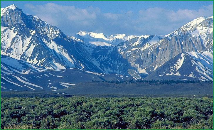
Inyo Mountains from Saline Valley (341Fc) Ś James R. Nelson |
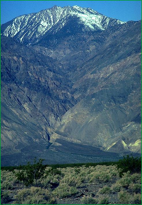
Inyo Mountains-McEluoy Canyon in the Inyo Mountains from Saline Valley Ś James R. Nelson |
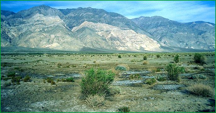
Saline Valley - Cottonwood Mountains- Saline Valley area Ś James R. Nelson |
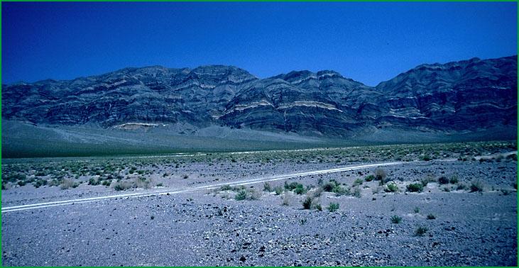
Eureka Valley area Ś James R. Nelson |
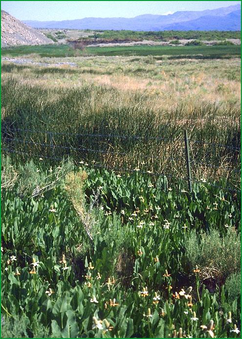
Anemiopsis californica in the Saline Valley Ś Julie Nelson |
http://www.fs.fed.us/r5/projects/ecoregions/341fa.htm
Subsection 341Fa
Silver Peak Mountains - Fish Lake Valley
This subsection is east of the White Mountains. It includes the Silver Peak Mountains, Palmetto Mountains, Magruder Mountain, Sylvania Mountains, and Fish Lake Valley. It has a temperate to cold, arid climate. MLRA 29f.
Lithology and Stratigraphy. The bedrock is mainly Jurassic and Cretaceous granitic; Tertiary and Quaternary andesite and basalt; Tertiary silicic pyroclastic; Precambrian sedimentary; and early Paleozoic, mostly Ordovician, sedimentary rocks. Quaternary alluvium covers about one-half of the subsection.
Geomorphology. This subsection contains steep mountains, moderately steep hills, gently to moderately sloping alluvial fans, and nearly level floodplain and basin floor. The mountains are aligned north-south on the west side of Clayton Valley (adjacent subsection) and curve around the south end of the valley toward the northeast on the east side of Clayton Valley. The elevation range is from about 4700 feet in Fish Lake Valley up to 9407 feet in the Silver Peak Mountains. Mass wasting, fluvial erosion and deposition, and freeze-thaw are the main geomorphic processes.
Soils. The soils on granitic rocks, which is the predominant kind of rock in California, are mostly shallow Typic and Xeric Torriorthents and shallow Aridic Haploxerolls. Soils on older alluvial fans are mostly Xerollic and Duric Haplargids. Those on younger fans and basin floors are mostly Typic and Oxiaquic Torriorthents and Aeric Halaquepts. The soils are well drained, except for poorly drained soils on basin floors. Soil temperature regimes are mesic and frigid. Soil moisture regimes are mostly aridic, but some are aquic on basin floors.
Vegetation. The predominant natural plant communities are Big sagebrush series at lower elevations and Singleleaf pinyon series at higher elevations. Low sagebrush series is common on shallow soils. On somewhat poorly to poorly drained floodplains and basin floors there are Greasewood series and Saltgrass series.
Characteristic series by lifeform include:
Grasslands: Alkali sacaton series, Indian ricegrass series, Needle-and-thread series, Saltgrass series, Mulefat series.
Shrublands: Big sagebrush series, Bitterbrush series, Greasewood series, Hop-sage series. Low sagebrush series, Rubber rabbitbrush series, Shadscale series.
Forests and woodlands: Curlleaf mountain-mahogany series, Singleleaf pinyon series, Utah juniper series.
Climate. The mean annual precipitation is about 5 to 10 inches. Much of the precipitation is snow. Mean annual temperature is about 40░ to 52░ F. The mean freeze-free period is in the range from 100 to 200 days.
Surface Water. Runoff is rapid from alluvial fans and slow from basin floors. It drains to a salt flat in Fish Lake Valley.
Subsection 341Fb
Inyo Mountains
This subsection includes the Inyo Mountains, Malpais Mesa at the south end of the Inyo Mountains, and Deep Spring Valley. It has a temperate to cold, arid climate. MLRA 29f.
Lithology and Stratigraphy. The bedrock is mainly Mesozoic granitic; Precambrian sedimentary and metamorphic; Paleozoic marine sedimentary; Triassic marine sedimentary; and Triassic - Jurassic metavolcanic rocks. Nearly all of the Paleozoic is represented, from Cambrian through Permian. Bedrock on and around Malpais Mesa is Pliocene volcanic rocks, mostly basalt. The Quaternary is represented by both alluvial and lacustrine deposits in Warm Spring Valley and alluvial deposits in other much smaller valleys in the Inyo Mountains.
Geomorphology. This subsection contains steep mountains, gently to moderately sloping alluvial fans and mesa, and nearly level floodplain and basin floor. The mountains are aligned north-northwest, except southeast of Deep Spring Valley where they are aligned north-northeast. The elevation range is from about 4000 feet up to 11,124 feet on Waucoba Mountain in the Inyo Mountains. Mass wasting, fluvial erosion and deposition, and freeze-thaw are the main geomorphic processes.
Soils. The soils are mostly Lithic Torriorthents, Lithic Xerollic Haplargids, and Lithic and Aridic Argixerolls. On granitic rocks they are mostly shallow Typic Torriorthents and shallow Entic Haploxerolls. Soils on alluvial fans and basin floors are mostly Typic Torriorthents, Xerollic Camborthids, and Typic Durargids, plus Xerollic Haplargids on older alluvial fans. The soils are well drained. Soil temperature regimes are mesic and frigid. Soil moisture regimes are mostly aridic, and some xeric.
Vegetation. The predominant natural plant communities are Big sagebrush series at lower and Singleleaf pinyon series at higher elevations. Low sagebrush series is common on shallow soils. Limber pine series and Bristlecone pine series occur at high elevations in the Inyo Mountains. Shadscale series, Mixed saltbush series, and Desert scrub shrublands predominate at lower elevations at the southern end of the subsection. Other communities and habitats in this subsection include Curlleaf mountain mahogany series, Aspen series where snow accumulates, Willow thicket shrublands and Montane meadow habitats.
Characteristic series by lifeform include:
Grasslands: Ashy ryegrass series, Beaked sedge series, Creeping ryegrass series, Indian ricegrass series, Nebraska sedge series, Needle-and-thread series.
Shrublands: Big sagebrush series, Black bush series, Bitterbrush series, Catclaw acacia series, Creosote bush series, Hop-sage series. Low sagebrush series, Rabbit rubberbrush series.
Forests and woodlands: Bristlecone pine series, Curlleaf mountain-mahogany series, Limber pine series, Singleleaf pinyon series, Singleleaf pinyon - Utah juniper series, Utah juniper series.
Climate. The mean annual precipitation is about 8 to 16 inches. Much of the precipitation is snow. Mean annual temperature is about 35░ to 54░ F. The mean freeze-free period is in the range from 75 to 225 days.
Surface Water. Runoff is rapid from alluvial fans and slow from basin floors. It drains to closed basins in the Owens Valley on the west, Eureka and Saline Valley on the east, or to Deep Spring Valley on the north. Streams are dry most of each year. There is a lake on the lacustrine plain in Deep Spring Valley.
Subsection 341Fc
Saline Valley - Cottonwood Mountains
This subsection is between the Inyo Mountains and Death Valley. It includes the Last Chance Range, Saline Range, Cottonwood Mountains, Nelson Range, Saline Valley, Eureka Valley, and many smaller valleys. It has a hot to temperate, arid climate. MLRA 29f.
Lithology and Stratigraphy. The bedrock is mainly Mesozoic granitic; Paleozoic marine sedimentary; and Tertiary volcanic rocks. Most all of the Paleozoic is represented, at least from Cambrian through Carboniferous. Pliocene volcanic rocks are mostly basalt, but there are other Tertiary volcanic rocks that are silicic. The Quaternary is represented by both alluvial and, in Saline, Eureka, and Racetrack Valleys, lacustrine deposits. Eolian sand deposits are extensive in Saline and Eureka Valleys.
Geomorphology. This subsection contains steep mountains, moderately steep hills, gently to moderately sloping alluvial fans and pediments, and nearly level floodplain and basin floor. Most of the mountains are aligned north-south, but the Nelson Range is aligned toward the northwest. There are high plateaus in the Nelson Range and on Hunter Mountain that appear to be old pediments. The elevation range is from about 1100 feet up to 7063 in the Saline Range, 7701 in the Nelson Range, 7454 on Hunter Mountain, 8456 in the Last Chance Range, and 8953 feet on Tin Mountain in the Cottonwood Mountains. Mass wasting, fluvial and eolian erosion and deposition, and freeze-thaw are the main geomorphic processes.
Soils. The soils on mountains and hills are mostly Lithic Torriorthents and Aridic Argixerolls, plus shallow Typic Torriorthents and shallow Aridic Haploxerolls on granitic rocks and Lithic Haplargids on volcanic rocks. Soils on alluvial fans and basin floors are mostly Typic and Xeric Torriorthents, plus Xerollic Haplargids and shallow Durorthids on older alluvial fans. There are Typic Salorthids on lacustrine deposits. The soils are well drained, except for poorly drained soils on lacustrine deposits. Soil temperature regimes are mostly thermic and mesic, with some frigid at higher elevations. Soil moisture regimes are aridic, except aquic in some lacustrine deposits.
Vegetation. The predominant natural plant communities, from lower to higher elevations, are Desert scrub shrublands and Mixed saltbush series on and around basin floors, Creosote bush series, Black bush series, Big sagebrush series, and Singleleaf pinyon series. Pickleweed series, Saltgrass series, and Greasewood series occur around poorly drained lake plains.
Characteristic series by lifeform include:
Grasslands: Alkali sacaton series, Indian ricegrass series, Pickleweed series, Saltgrass series.
Shrublands: Black bush series, Catclaw acacia series, Creosote bush series, Fourwing saltbush series, Greasewood series, Hop-sage series. Iodine bush series, Mixed saltbush series, Shadscale series, Mulefat series.
Forests and woodlands: Curlleaf mountain-mahogany series, Singleleaf pinyon series, Singleleaf pinyon - Utah juniper series, Utah juniper series.
Climate. The mean annual precipitation is about 5 to 12 inches. Much of the precipitation is snow at higher elevations. Mean annual temperature is about 40░ to 70░ F. The mean freeze-free period is in the range from 125 to 275 days.
Surface Water. Runoff is rapid from alluvial fans and slow from basin floors. Some of it drains to Death Valley and the remainder drains to closed basins within the subsection. Streams are dry most of each year.
Subsection 341Fd
Grapevine Mountains
This subsection includes the Grapevine Mountains on the northeast side of Death Valley and the Slate Range and Gold Mountain north of the Grapevine Mountains. It has a hot to temperate, arid climate. MLRA 29f.
Lithology and Stratigraphy. The bedrock is mainly Paleozoic marine sedimentary and Tertiary and Quaternary volcanic rocks, plus Jurassic granitic rocks in the Slate Range. Most of the Paleozoic is represented, at least from Cambrian through Carboniferous. The volcanic rocks are mostly basalt and pyroclastics. There is some Quaternary alluvium in small valleys.
Geomorphology. This subsection contains steep mountains, moderately steep hills, and gently to moderately sloping alluvial fans. Most of the Grapevine Mountains are aligned toward the north-west and the Slate Range and Gold Mountain are slightly curved toward the north-northeast to northeast. The elevation range is from about 1000 feet up to 8331 in the Grapevine Mountains. Mass wasting, fluvial and deposition, and freeze-thaw are the main geomorphic processes.
Soils. The soils are mostly Lithic Torriorthents, shallow Typic and Xerollic Haplargids, and Aridic Argixerolls, plus Lithic Haplargids on volcanic rocks. Soils on alluvial fans are mostly Typic Torriorthents, Typic Haplargids, and shallow Typic Durorthids. The soils are well drained. Soil temperature regimes are thermic and mesic. Soil moisture regimes are aridic.
Vegetation. The predominant natural plant communities, from lower to higher elevations are Mixed salt bush series, Shadscale series, Black bush series, Big sagebrush series, and Singleleaf pinyon series.
Characteristic series by lifeform include:
Grasslands: Indian ricegrass series, Needle-and-thread series.
Shrublands: Black bush series, Catclaw acacia series, Creosote bush series, Creosote bush - white bursage series, Hop-sage series, White bursage series.
Forests and woodlands: Bristlecone pine series, Curlleaf mountain-mahogany series, Singleleaf pinyon series, Singleleaf pinyon - Utah juniper series, Utah juniper series.
Climate. The mean annual precipitation is about 4 to 10 inches. Much of the precipitation is snow at higher elevations. Mean annual temperature is about 40░ to 72░ F. The mean freeze-free period is in the range from 150 to 275 days.
Surface Water. Runoff is rapid. It drains to Death Valley on the southwest or to Sarcobatus Flat or the Amargosa River on the east. Streams are dry most of each year.