 | Surprise Valley-Sheldon Range-Honey Lake Basin- Cottonwood - Skedaddle Mountains |
Surprise Valley Ś James R. Nelson |
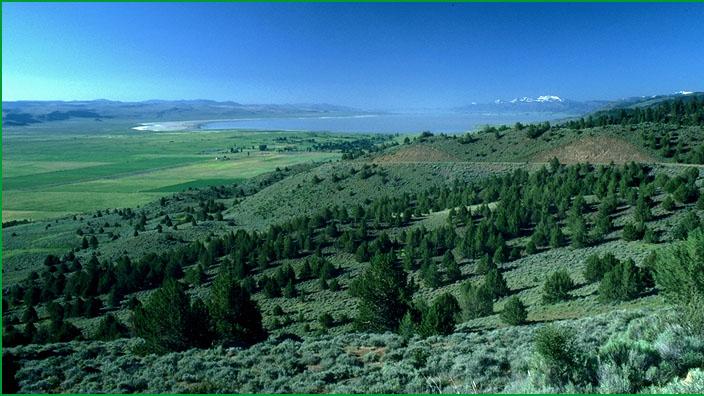
Eastern shore area of Honey Lake Ś Scott Miles |
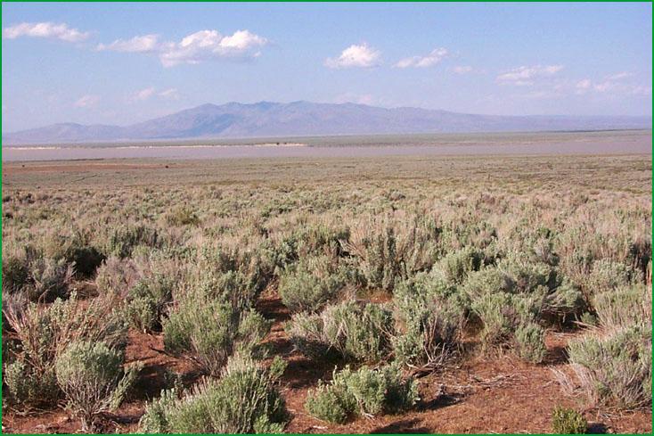
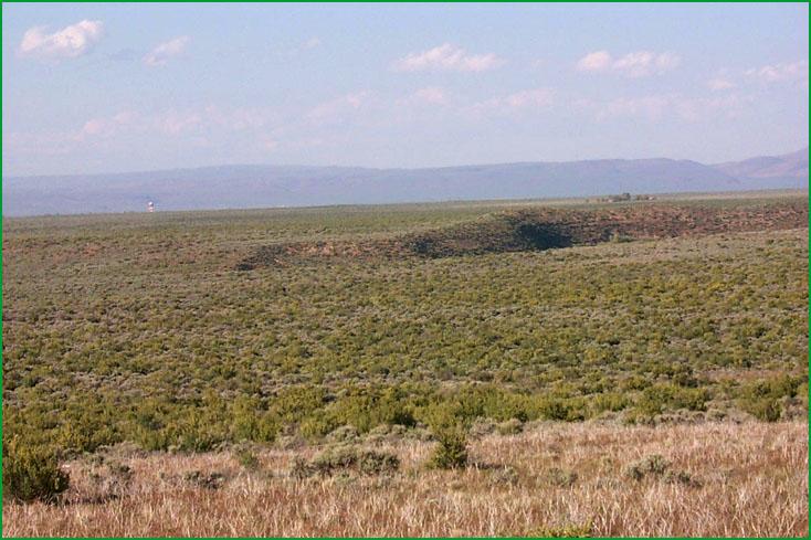
Honey Lake Basin, south of Honey Lake Ś Scott Miles |
http://www.fs.fed.us/r5/projects/ecoregions/342ba.htm
Subsection 342Ba
Surprise Valley
This subsection comprises the Surprise Valley, which is east of the Warner Mountains. The climate is temperate, and semi-arid. MLRAs 23f and 23g.
Lithology and Stratigraphy. Quaternary alluvial and lacustrine deposits predominate in this subsection. There are minor eolian deposits.
Geomorphology. Very gently to moderately sloping alluvial fans and nearly level floodplain and basin floors predominate in this subsection. Most of the basin floor is a lake plain with remnants of a formerly much larger lake. The valley is aligned north-south, parallel to the Warner Mountains from which it is separated by the Surprise Valley Fault. The elevation range is about 4430 to 5100 feet. Fluvial erosion and deposition, lacustrine deposition, and freeze-thaw are the main geomorphic processes.
Soils. Soils on alluvial fans and floodplains are mostly Aridic Haploxerolls and Fluvaquentic Endoaquolls. Those on basin floors are mostly Durixerollic Haplargids, Xerollic Natrargids, Duric Camborthids, Aeric Haplaquepts, and Oxyaquic Torriorthents. The soils are well to poorly drained. Soil temperature regimes are mesic. Soil moisture regimes are mostly aridic on alluvial fans and aquic on basin floors.
Vegetation. The predominant natural plant communities are Big sagebrush series on fans, and Mixed saltbush series, Greasewood series, Saltgrass series, and Sedge meadow communities on floodplains and basin floors.
Characteristic series by lifeform include:
Grasslands: Alkali sacaton series, Ashy ryegrass series, Beaked sedge series, Creeping ryegrass series, Indian ricegrass series, Needle-and-thread series, Saltgrass series.
Shrublands: Big sagebrush series, Bitterbrush series, Bush seepweed series, Fourwing saltbush series, Greasewood series, Low sagebrush series, Mixed saltbush series, Rubber rabbitbush series, Shadscale series.
Climate. The mean annual precipitation is about 4 to 16 inches. Much of the precipitation is snow. Mean annual temperature is about 45░ to 50░ F. The mean freeze-free period is in the range from 100 to 125 days.
Surface Water. Runoff is rapid from alluvial fans and slow on basin floors. Surprise Valley has a closed drainage system. There are currently three lakes in the valley, where there was one larger lake during the Pleistocene. Only larger streams draining into the valley are perennial; smaller streams are dry during summer.
Subsection 342Bb
Sheldon Range
This subsection is a volcanic plateau northeast of Surprise Valley. The climate is temperate to cold, and semi-arid. MLRAs 21e and 23f.
Lithology and Stratigraphy. The bedrock is predominantly Miocene basalt and lesser amounts on Miocene rhyolite and pyroclastic rocks. There are some alluvial and lacustrine deposits in small depressions.
Geomorphology. Gently to moderately sloping plateau with few moderately steep hills predominates in this subsection. The fault-line scarp on the eastern edge of Mount Bidwell, which is on the western margin of the subsection, is steep. The plateau lacks a well integrated drainage system; there are many small closed depressions. The elevation range is about 4500 to 6000 feet on the plateau and up to 8000 feet on a fault-line scarp along the western edge of the subsection. Fluvial erosion and deposition and freeze-thaw are the main geomorphic processes. Volcanism is no longer an active process.
Soils. Soils are mostly Lithic Xerollic Haplargids, Lithic and Pachic Argixerolls, Xerollic Natrargids, Abruptic Xerollic Durargids, and Pachic and Argic Cryoborolls. The soils are well drained. Soil temperature regimes are mostly frigid and cryic, but mesic around the alluvial plain in Surprise Valley. Soil moisture regimes are mostly aridic and xeric.
Vegetation. The predominant natural plant community is Big sagebrush series. Shadscale series occurs in the drier areas. Rubber rabbitbrush series occurs on disturbed sites.
Characteristic series by lifeform include:
Grasslands: Ashy ryegrass series, Bluebunch wheatgrass series, Creeping ryegrass series, Indian ricegrass series, Needle-and-thread series.
Shrublands: Big sagebrush series, Bitterbrush series, Low rabbitbrush series, Rubber rabbitbrush series.
Forests and woodlands: Curlleaf mountain-mahogany series.
Climate. The mean annual precipitation is about 10 to 20 inches. Much of the precipitation is snow. Mean annual temperature is about 30░ to 48░ F. The mean freeze-free period range is from 25 to 125 days.
Surface Water. Runoff from uplands is rapid, but water ponds in small depressions. Most of the drainage is internal, to closed depressions in the subsection. There are few streams and most of those are dry during summer.
Subsection 342Bc
Honey Lake Basin
This subsection comprises the bottom of Honey Lake Valley, just northwest of the Diamond Mountains, which are at the northwest end of the Sierra Nevada. The climate is temperate and arid to semi-arid. MLRAs 23f and 23g.
Lithology and Stratigraphy. Quaternary alluvial and lacustrine deposits predominate in this subsection. There are minor eolian deposits. Some Tertiary andesite and pyroclastic rocks are included in this subsection.
Geomorphology. Gently sloping to nearly level alluvial fans, floodplain, and basin floor predominate in this subsection, forming a large alluvial - lacustrine plain. Slopes are moderately steep to steep on Bald Mountain, which is near the center of this alluvial - lacustrine plain. Honey Lake is a remnant of much larger Pleistocene and older lakes that occupied the valley. There are small remnants of Tertiary lacustrine and Quaternary fluvial terraces. Tufa mounds are common. The valley is aligned toward the north-west, parallel to the very steep northeastern edge of the Diamond Mountains. The elevation range is about 3980 feet on the current surface of Honey Lake to 4200 feet on the alluvial - lacustrine plain and 5221 feet on Bald Mountain. Fluvial and eolian erosion and deposition, lacustrine deposition, and freeze-thaw are the main geomorphic processes.
Soils. Soils on bedrock are mostly Pachic Haploxerolls, and Aridic and shallow Aridic Argixerolls. Those on the alluvial - lacustrine plains are Typic, Xerollic, and Natric Camborthids; Torripsammentic, Cumulic, Fluvaquentic, Calcidic, and Aridic Duric Haploxerolls; Aridic Argixerolls; Xerollic and Durixerollic Haplargids; Haploxerollic and Durixerollic Natrargids; Fluvaquentic Endoaquolls; Aeric Halaquepts; and Xeric Endoaquerts. The soils are well to poorly drained. Soil temperature regimes are mesic. Soil moisture regimes are mostly aridic and aquic, and some xeric on the north side of Bald Mountain.
Vegetation. The predominant natural plant communities on well drained soils are Big sagebrush series on the west and Shadscale series on the east. On somewhat poorly to poorly drained soils, the predominant natural plant communities are Mixed saltbush series and Saltgrass series and Sedge meadow communities.
Characteristic series by lifeform include:
Grasslands: Alkali sacaton series, Ashy ryegrass series, Bluebunch wheatgrass series, Creeping ryegrass series, Indian ricegrass series, Needle-and-thread series, Saltgrass series.
Shrublands: Big sagebrush series, Bush seepweed series, Fourwing saltbush series, Greasewood series, Mixed saltbush series, Rubber rabbitbrush series, Scadscale series, Winter fat series.
Forests and woodlands: Mountain juniper series, Western juniper series.
Climate. The mean annual precipitation is about 4 to 8 inches. Much of the precipitation is snow. Mean annual temperature is about 48░ to 52░ F. The mean freeze-free period is in the range from 100 to 150 days.
Surface Water. The Susan River entering the valley from the northwest, Willow from the north, and several streams from the Diamond Mountains are perennial, but all streams on the east side of the valley are dry during summer.
Subsection 342Bd
Cottonwood - Skedaddle Mountains
This subsection is on the drier margin of the Modoc Plateau between Surprise Valley and Honey Lake. The climate is temperate to cold and semi-arid. MLRAs 23f and 23g.
Lithology and Stratigraphy. The bedrock is predominantly Pliocene and Quaternary basalt and lesser amounts of older Tertiary pyroclastic rocks and sediments. Quaternary alluvial deposits are inextensive and Tertiary and Quaternary lacustrine deposits are moderately extensive.
Geomorphology. There are many volcanic peaks with steep sideslopes and gently to moderately sloping lava flow surfaces between peaks. There has been enough fluvial erosion to form locally integrated drainage systems, but not enough to drain all basins nor to severely dissect lacustrine sediments in basins that have been drained naturally. A few drainages remain closed, but most streams drain to closed basins outside of this subsection. The elevation range is from about 4200 feet up to 7552 feet in the Skedaddle Mountains. There are many peaks between 6000 to 7000 feet elevation. Fluvial erosion and freeze-thaw are the main geomorphic processes. Volcanism is no longer an active process.
Soils. Soils in volcanic terrain are mostly Lithic and Aridic Argixerolls and lesser amounts of Cryoborolls, Camborthids, Haplargids, and Haploxererts. Those on alluvial and lacustrine plains are Cumulic, Fluvaquentic, and Aridic Duric Haploxerolls; Aridic Argixerolls; Xerollic and Durixerollic Haplargids; and Chromic Haploxererts. Most of the soils are well drained; some are somewhat poorly drained. Soil temperature regimes are mostly mesic and frigid, with some cryic on north-facing slopes at higher elevations. Soil moisture regimes are mostly aridic, but some are xeric on alluvial and lacustrine plains.
Vegetation. The predominant natural plant communities are Big sagebrush series on the west and Shadscale series on the east side of the subsection. Also, there is some Low sagebrush series on shallow soils and Western juniper series in the western part of the subsection.
Characteristic series by lifeform include:
Grasslands: Ashy ryegrass series, Breaked sedge series, Bluebunch wheatgrass series, Creeping ryegrass series, Indian ricegrass series, One-sided bluegrass series.
Shrublands: Big sagebrush series, Bitterbrush series, Fourwing saltbush series, Low sagebrush series, Rubber rabbitbrush series, Shadscale series.
Forests and woodlands: Curlleaf mountain-mahogany series, Western juniper series.
Climate. The mean annual precipitation is about 6 to 12 inches. Much of the precipitation is snow. Mean annual temperature is about 35░ to 50░ F. The mean freeze-free period is in the range from 50 to 125 days.
Surface Water. Runoff is rapid from uplands and slow on alluvial and lacustrine plains. Most of the drainage is to Honey Lake Valley on the south, Smoke Creek Valley on the east, or Surprise Valley on the north; little is to closed basins within the subsection. Most of the streams are dry during summer.
Subsection 342Be
Madeline Plains
This subsection comprises the Madeline Plains and contiguous plains in Grasshopper and Dry Valleys. They are near the eastern edge of the Modoc Plateau. The climate is temperate and semi-arid.
Lithology and Stratigraphy. Quaternary lacustrine deposits predominate in this subsection. There is some Pliocene basalt and minor Quaternary alluvial and eolian deposits.
Geomorphology. Nearly level lake plain predominates in this subsection. There are a few small, sloping to moderately steep hills sticking up through the lacustrine plain and eolian sand deposits on the east side of the plain. The elevation range is from 5284 feet to about 5400 feet on the alluvial - lacustrine plain and up to 5741 feet on Dill Butte. Fluvial and eolian erosion and deposition, lacustrine deposition, and freeze-thaw are the main geomorphic processes.
Soils. Soils on bedrock are mostly Lithic and Typic Argixerolls and Entic Chromoxererts. Those on the lacustrine plain are Chromic Haploxererts; Cumulic, Fluvaquentic, and Aridic Duric Haploxerolls; Aridic Argixerolls; and Xerollic and Durixerollic Haplargids. The soils are well to somewhat poorly drained. Soil temperature regimes are mesic. Soil moisture regimes are mostly aridic and xeric.
Vegetation. The predominant natural plant communities are Big sagebrush series and, on somewhat poorly to poorly drained soils, Sedge meadow communities.
Characteristic series by lifeform include:
Grasslands: Ashy ryegrass series, Breaked sedge series, Creeping ryegrass series, Indian ricegrass series.
Shrublands: Big sagebrush series, Bitterbrush series, Low sagebrush series, Rubber rabbitbrush series.
Climate. The mean annual precipitation is about 8 to 12 inches. Much of the precipitation is snow. Mean annual temperature is about 45░ to 48░ F. The mean freeze-free period is in the range from 75 to 100 days.
Surface Water. There is no overland drainage from the Madeline Plain, but streams from the surrounding area are dry much of each year and carry too little water to the plain to create a lake.