 | Scott Bar Mountain -Lower Salmon Mountains-Upper Salmon Mountains-Scott Valley |
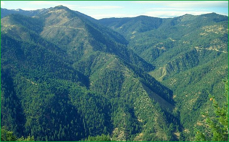
Scott Bar Mountain-near Scott Bar Mountain Ś Tom Laurent |
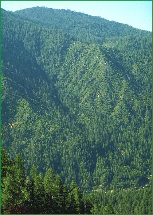
Lower Salmon Mountains -lower elevations of Salmon Mountains Ś Tom Laurent |
Hotelling Ridge from Trinity Alps Wilderness Ś Tom Laurent |
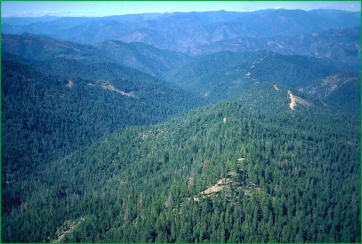
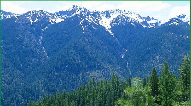
Upper Salmon Mountains-Wayne Steffes |
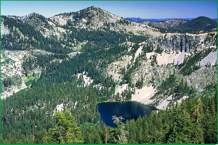
Boulder Peak in Marble Mountain Wilderness Ś Tom Laurent |
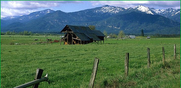
Scott Valley-Tom Laurent |
http://www.fs.fed.us/r5/projects/ecoregions/m261ae.htm
Subsection M261Ae
Scott Bar Mountain
This subsection is on mountains around the lower stretch of the Scott River and the middle stretch of the Klamath River. It is in the Western Paleozoic and Triassic Belt and includes some of the Condrey Mountain schist. It has a temperate and subhumid to humid climate. MLRA 5d.
Lithology and Stratigraphy. This subsection contains a variety of Paleozoic to Jurassic metavolcanic and metasedimentary rocks, including components of ophiolitic sequences, of the Rattlesnake Creek, Western Hayfork, and Sawyers Bar terranes. Metamorphic rocks of the Stuart Fork Formation occur between the Soap Creek Ridge fault and the Eastern Klamath Belt. The rocks of this subsection were intruded by Mesozoic granitic rocks, generally quartz diorite to slightly more silicic rocks. The Condrey Mountain Schist, some of which is in this subsection, is a greenschist - blueschist facies volcanic sequence and subduction complex. Cretaceous marine sedimentary rocks of the Hornbrook Formation cover the eastern edge of the subsection.
Geomorphology. This is a subsection of mountains with rounded ridges, steep sides, and narrow canyons. Although the mountains are generally aligned toward the north, the Scott Bar Mountains are aligned toward the east-northeast, nearly parallel to the Soap Creek Ridge fault that separates this subsection from the Eastern Klamath Belt. Slopes on Condrey Mountain Schist are generally moderately steep, rather than steep, reflecting its susceptibility to mass wasting. The elevation range is about 1500 to 6300 feet. Mass wasting and fluvial erosion are the main geomorphic processes.
Soils. The soils are mostly Dystric and Dystric Lithic Xerochrepts and Ultic Haploxeralfs. Typic and Pachic Xerumbrepts occur at higher elevations. Soils on granitic rocks are mostly Dystric and shallow Dystric Xerochrepts. Soils on Cretaceous marine sedimentary rocks are mostly Mollic Haploxeralfs, Vertic Argixerolls, and Leptic Haploxererts. The soils are well drained. Soil temperature regimes are predominantly mesic, with some frigid at higher elevations. Soil moisture regimes are xeric.
Vegetation. The predominant natural plant communities are Mixed conifer series and Douglas-fir - ponderosa pine series, and, on ultramafic rocks, Jeffrey pine series and Foxtail pine series. Canyon live oak series is common on very steep rocky slopes with stony soils. White fir series, and some Red fir series and Mixed subalpine forest series, occur at higher elevations. Oregon white oak series occurs on the east side of the subsection, particularly on Cretaceous marine sedimentary rocks.
Characteristic series by lifeform include:
Grasslands: California annual grassland series, Montane meadow habitat, Nebraska sedge series, Rocky Mountain sedge series.
Shrublands: Big sagebrush series, Brewer oak series, Curlleaf mountain-mahogany series, Bush chinquapin series, Greenleaf manzanita series, Holodiscus series, Huckleberry oak series, Montane wetland shrub habitat, Mountain alder series, Rubber rabbitbrush series, Sitka alder series, Subalpine upland shrub habitat, Subalpine wetland shrub habitat, Tobacco brush series, Wedgeleaf ceanothus series, Whiteleaf manzanita series.
Forests and woodlands: Baker cypress stands, Black oak series, Canyon live oak series, Douglas-fir - Ponderosa pine series, Foxtail pine series, Jeffrey pine series, Mountain hemlock series, Oregon white oak series, Ponderosa pine series, Red fir series, Western juniper series, White fir series.
Climate. The mean annual precipitation is about 20 to 60 inches. Most of the precipitation is rain at lower elevations, but much of it is snow at higher elevations. Mean annual temperature is about 42░ to 54░ F. The mean freeze-free period is about 75 days at higher elevations to 175 days at lower elevations.
Surface Water. Runoff is rapid. It drains to the Scott and Klamath Rivers, which flow through the subsection. All but the larger streams are dry through much or most of summer. There are no lakes in the subsection.
Subsection M261Af
Lower Salmon Mountains
This subsection is in the Western Paleozoic and Triassic Belt, near the Klamath River from Thompson Creek to south of the Salmon River. The climate is temperate and humid. MLRA 5c.
Lithology and Stratigraphy. This subsection contains a variety of Paleozoic to Jurassic metavolcanic and metasedimentary rocks, including components of ophiolitic sequences, of mostly Western Hayfork and Rattlesnake Creek terranes, and some Sawyers Bar terrane up Wooley Creek. The rocks were intruded by Mesozoic granitic rocks, generally quartz diorite to slightly more silicic rocks.
Geomorphology. This is a subsection of mountains with rounded ridges, steep sides, and narrow canyons. Both large and small landslides are common. Slopes on highly serpentinized peridotite are generally moderately steep, rather than steep, reflecting its susceptibility to mass wasting. There are narrow floodplains and high terraces along the Klamath River and its tributaries. The elevation range is about 600 to nearly 5000 feet. Mass wasting and fluvial erosion are the main geomorphic processes.
Soils. The soils are mostly Dystric and Dystric Lithic Xerochrepts, Ultic Haploxeralfs, and Typic Haploxerults. Soils on granitic rocks are mostly Dystric and shallow Dystric Xerochrepts. Typic Argixerolls and Typic and Mollic Haploxeralfs occur on serpentinite and serpentinized peridotite. Xeric Haplohumults occur on high terraces and other stable land surfaces. The soils are well drained. Soil temperature regimes are mesic. Soil moisture regimes are xeric.
Vegetation. The predominant natural plant communities are Douglas-fir - tanoak series, Douglas-fir series, and Mixed conifer series, and, on ultramafic rocks, Jeffrey pine series. Canyon live oak series is common on very steep rocky slopes with stony soils. White fir series occurs at higher elevations.
Characteristic series by lifeform include:
Grasslands: California annual grassland series.
Shrublands: Brewer oak series, Greenleaf manzanita series, Huckleberry oak series, Sadler oak series, Tobacco brush series, Wedgeleaf ceanothus series, Whiteleaf manzanita series.
Forests and woodlands: Black oak series, Canyon live oak series, Douglas-fir series, Douglas-fir - ponderosa pine series, Douglas-fir - tanoak series, Jeffrey pine series, Knobcone pine series, Oregon white oak series, Tanoak series, White alder series, White fir series.
Climate. The mean annual precipitation is about 50 to 80 inches. Most of the precipitation is rain at lower elevations, with some snow at higher elevations. Mean annual temperature is about 45░ to 57░ F. The mean freeze-free period is about 100 days at higher elevations to 200 days at lower elevations.
Surface Water. Runoff is rapid. It drains to the Klamath River, which flows through the subsection. The larger streams are perennial. There are no lakes in the subsection.
Subsection M261Ag
Upper Salmon Mountains
This subsection is near the center of the Western Paleozoic and Triassic Belt. It includes the Marble Mountains and mountains from there south-southeast to Deadman Peak in the Salmon Mountains. The climate is cold and humid. MLRAs 5c and 5d.
Lithology and Stratigraphy. This subsection is dominated by Mesozoic granitic rocks and Paleozoic to Jurassic metavolcanic and metasedimentary rocks, including serpentinized peridotite, of mostly Western Hayfork terrane, Rattlesnake Creek terrane north of the Marble Mountain fault, and Sawyers bar terrane south of the Marble Mountain fault. Stuart Fork Formation terrane occurs in the south end of the subsection, southeast of the Soap Creek Ridge fault. The granitic rocks are generally quartz diorite to slightly more silicic rocks. Quaternary glacial till and outwash occur in many small areas.
Geomorphology. This is a subsection of mountains with rounded summits, steep sides, and narrow canyons. The mountains are generally aligned toward the north, although the Marble Mountain fault strikes east-west. There are many cirques and moraines in mountain valleys. The elevation range is from about 4500 feet up to 8299 feet on Boulder Peak. Mass wasting and fluvial erosion are the main geomorphic processes. Glacial processes have also been prominent.
Soils. The soils are mostly Lithic, Typic, and Pachic Xerumbrepts and Dystric Xerochrepts on metamorphic rocks, with Haploxerolls on marble. Soils on granitic rocks are mostly Lithic, Entic, Typic, and Pachic Xerumbrepts. Rock outcrop is extensive and Cryumbrepts, Cryochrepts, and Cryoborolls occur at higher elevations. Typic Xerumbrepts occur on glacial till. The soils are well drained, except in small glacial basins. Soil temperature regimes are predominantly frigid, with cryic at higher elevations. Soil moisture regimes are xeric.
Vegetation. The predominant natural plant community is White fir series, with Red fir series, Mountain hemlock series, Mixed subalpine forest series, and Subalpine meadow habitats at higher elevations.
Characteristic series by lifeform include:
Grasslands: Green fescue series, Montane meadow habitat, Nebraska sedge series, Rocky Mountain sedge series, Shorthair reedgrass series, Subalpine meadow habitat.
Seeps: Darlingtonia series.
Shrublands: Brewer oak series, Bush chinquapin series, Greenleaf manzanita series, Holodiscus series, Huckleberry oak series, Low sagebrush series, Montane wetland shrub habitat, Mountain alder series, Mountain heather - bilberry series, Sadler oak series, Sitka alder series, Subalpine upland shrub habitat, Subalpine wetland shrub habitat, Tobacco brush series, Wedgeleaf ceanothus series.
Forests and woodlands: Aspen series, Curlleaf mountain-mahogany series, Douglas-fir series, Enriched stands in the Klamath Mountains, Engelmann spruce series, Foxtail pine series, Incense-cedar series, Jeffrey pine series, Lodgepole pine series, Mixed conifer series, Mixed conifer subalpine series, Mountain hemlock series, Pacific silver fir stands, Red fir series, Subalpine fir series, Western white pine series, White fir series, Whitebark pine series.
Climate. The mean annual precipitation is about 60 to 90 inches. Much of the precipitation is snow, especially at higher elevations. Mean annual temperature is about 35░ to 46░ F. The mean freeze-free period is about 25 days at higher elevations to 100 days at lower elevations.
Surface Water. Runoff is rapid. It drains to the Salmon, Scott, and Klamath Rivers and their tributaries. Streams are mostly perennial. There are many small lakes, or ponds, in cirque and paternoster basins.
Subsection M261Ah
Scott Valley
This subsection comprises a large valley along the Scott River. It includes Quartz Hill and Chaparral Hill in the north end of the valley. It has a temperate and subhumid climate. MLRA 21e.
Lithology and Stratigraphy. Scott Valley is filled with alluvium derived from Paleozoic to Jurassic metavolcanic, metasedimentary, plutonic, and ultramafic rocks of the Western Paleozoic and Triassic, Eastern Klamath, and Central Metamorphic Belts that are in the mountains around the valley. Chaparral Hill is composed of Stuart Fork Formation rocks and Quartz Hill is in Sawyers Bar terrane of the Western Paleozoic and Triassic Belt.
Geomorphology. This subsection is dominated by a nearly level basin floor and by sloping alluvial fans that skirt the valley. Slopes on the hills are mostly steep. The elevation range is about 2700 on the valley floor up to 4238 feet on Quartz Hill. Fluvial erosion and deposition are the main geomorphic processes.
Soils. The soils are mostly Fluvaquentic Haploxerolls and Fluvaquentic Endoaquolls on basin floor and Xerochrepts and Argixerolls on alluvial fans. Ultic Haploxeralfs occur on the hills. The soils are well to poorly drained. Soil temperature regimes are mesic. Soil moisture regimes are xeric and aquic.
Vegetation. The predominant natural plant communities are Oregon white oak series, Ponderosa pine series, and Native grassland, Sedge meadow, and Emergent aquatic communities. Ponderosa pine series and Douglas-fir - ponderosa pine series occur around the margins of the valley and on hills in the valley.
Characteristic series by lifeform include:
Grasslands: Bluebunch wheatgrass series, California annual grassland series, Idaho fescue series, Sedge series, Tufted hairgrass series.
Shrublands: Birchleaf mountain-mahogany series, Wedgeleaf ceanothus series.
Forests and woodlands: Black oak series, Douglas-fir - ponderosa pine series, Oregon white oak series, Ponderosa pine series, Water birch series, Western juniper series.
Climate. The mean annual precipitation is about 18 to 25 inches; most of it is rain. Mean annual temperature is about 45░ to 50░ F. The mean freeze-free period is about 100 days at higher elevations to 125 days on the valley floor.
Surface Water. Runoff is moderately rapid from alluvial fans and slow from basin floor. It drains to the Scott River, which flows through the subsection. There are no natural lakes in the subsection.
Subsection M261Ah
Scott Valley
This subsection comprises a large valley along the Scott River. It includes Quartz Hill and Chaparral Hill in the north end of the valley. It has a temperate and subhumid climate. MLRA 21e.
Lithology and Stratigraphy. Scott Valley is filled with alluvium derived from Paleozoic to Jurassic metavolcanic, metasedimentary, plutonic, and ultramafic rocks of the Western Paleozoic and Triassic, Eastern Klamath, and Central Metamorphic Belts that are in the mountains around the valley. Chaparral Hill is composed of Stuart Fork Formation rocks and Quartz Hill is in Sawyers Bar terrane of the Western Paleozoic and Triassic Belt.
Geomorphology. This subsection is dominated by a nearly level basin floor and by sloping alluvial fans that skirt the valley. Slopes on the hills are mostly steep. The elevation range is about 2700 on the valley floor up to 4238 feet on Quartz Hill. Fluvial erosion and deposition are the main geomorphic processes.
Soils. The soils are mostly Fluvaquentic Haploxerolls and Fluvaquentic Endoaquolls on basin floor and Xerochrepts and Argixerolls on alluvial fans. Ultic Haploxeralfs occur on the hills. The soils are well to poorly drained. Soil temperature regimes are mesic. Soil moisture regimes are xeric and aquic.
Vegetation. The predominant natural plant communities are Oregon white oak series, Ponderosa pine series, and Native grassland, Sedge meadow, and Emergent aquatic communities. Ponderosa pine series and Douglas-fir - ponderosa pine series occur around the margins of the valley and on hills in the valley.
Characteristic s