 | Scott Valley-Eastern Klamath Mountains- Upper Scott Mountains |
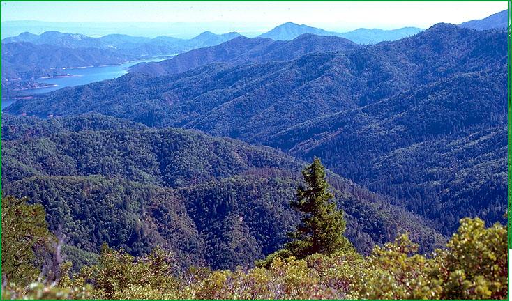
Eastern Klamath Mountains- Sugarloaf Creek area, Shasta Lake in background Ś Scott Miles |
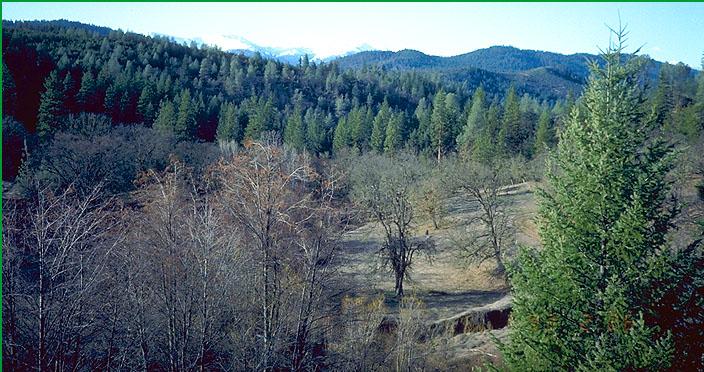
Lewiston area Ś Robert Ettner |
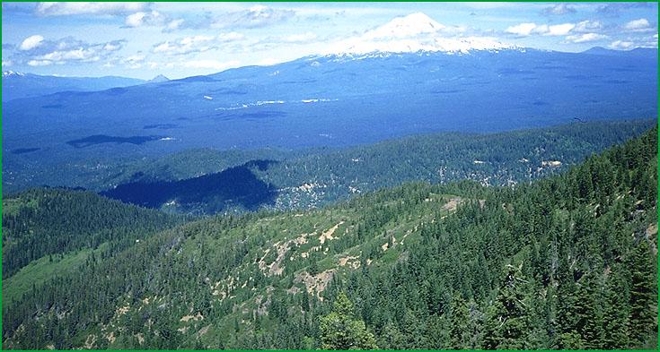
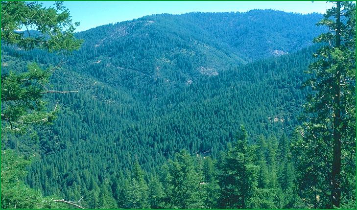
Subsection M261Ai in foreground, Section M261D in background Ś Scott Miles |
Subsection M261Ai, from above Hawkins Creek Ś Scott Miles |
Subsection M261Ai, East side of Trinity Lake looking toward Bragdon Gulch Ś Robert Ettner |
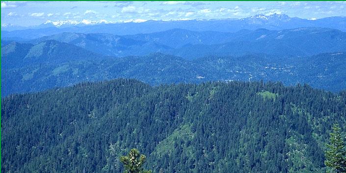
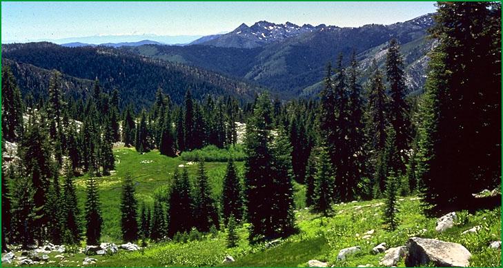
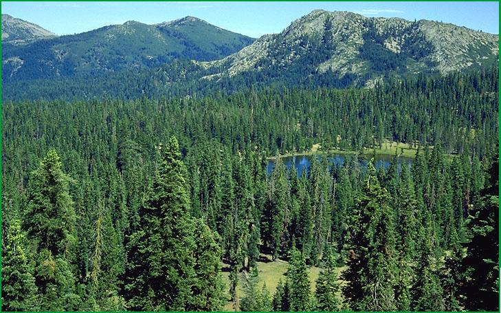
Upper Scott Mountains-Subsection M261Aj, upper Scott Mountains Ś Wayne Steffes |
Subsection M261Aj, Gumboot Lake Ś Julie Nelson |
http://www.fs.fed.us/r5/projects/ecoregions/m261ah.htm
Subsection M261Ah
Scott Valley
This subsection comprises a large valley along the Scott River. It includes Quartz Hill and Chaparral Hill in the north end of the valley. It has a temperate and subhumid climate. MLRA 21e.
Lithology and Stratigraphy. Scott Valley is filled with alluvium derived from Paleozoic to Jurassic metavolcanic, metasedimentary, plutonic, and ultramafic rocks of the Western Paleozoic and Triassic, Eastern Klamath, and Central Metamorphic Belts that are in the mountains around the valley. Chaparral Hill is composed of Stuart Fork Formation rocks and Quartz Hill is in Sawyers Bar terrane of the Western Paleozoic and Triassic Belt.
Geomorphology. This subsection is dominated by a nearly level basin floor and by sloping alluvial fans that skirt the valley. Slopes on the hills are mostly steep. The elevation range is about 2700 on the valley floor up to 4238 feet on Quartz Hill. Fluvial erosion and deposition are the main geomorphic processes.
Soils. The soils are mostly Fluvaquentic Haploxerolls and Fluvaquentic Endoaquolls on basin floor and Xerochrepts and Argixerolls on alluvial fans. Ultic Haploxeralfs occur on the hills. The soils are well to poorly drained. Soil temperature regimes are mesic. Soil moisture regimes are xeric and aquic.
Vegetation. The predominant natural plant communities are Oregon white oak series, Ponderosa pine series, and Native grassland, Sedge meadow, and Emergent aquatic communities. Ponderosa pine series and Douglas-fir - ponderosa pine series occur around the margins of the valley and on hills in the valley.
Characteristic series by lifeform include:
Grasslands: Bluebunch wheatgrass series, California annual grassland series, Idaho fescue series, Sedge series, Tufted hairgrass series.
Shrublands: Birchleaf mountain-mahogany series, Wedgeleaf ceanothus series.
Forests and woodlands: Black oak series, Douglas-fir - ponderosa pine series, Oregon white oak series, Ponderosa pine series, Water birch series, Western juniper series.
Climate. The mean annual precipitation is about 18 to 25 inches; most of it is rain. Mean annual temperature is about 45░ to 50░ F. The mean freeze-free period is about 100 days at higher elevations to 125 days on the valley floor.
Surface Water. Runoff is moderately rapid from alluvial fans and slow from basin floor. It drains to the Scott River, which flows through the subsection. There are no natural lakes in the subsection.
Subsection M261Ai
Eastern Klamath Mountains
This subsection is located in the southeastern part of the Klamath Mountains. It is bordered by the Sacramento Valley on the south, the Cascade Ranges on the east, and the Scott Mountains on the northwest. The climate is temperate and humid. MLRAs 5c and 22c.
Lithology and Stratigraphy. This subsection contains a variety of Devonian through Jurassic metavolcanic and metasedimentary rocks, including metamorphosed andesite, rhyolite, pyroclastic rock, graywacke, shale, minor chert, and limestone. From oldest to youngest, they are designated Copley greenstone, Kennett Formation, Bragdon Formation, Baird Formation, McCloud Limestone, Bollibokka Group, Pit Formation, Modin Formation, Arvison Formation, Bagley Andesite, and Potem Formation. Non marine sedimentary rocks of the Weaverville Formation occur in a north-northeast aligned graben that is parallel to the Trinity River in the Musser Hill area.
Geomorphology. This is a subsection of mountains with rounded summits, steep sides, and narrow canyons. It is hilly with moderately steep slopes, rather than mountainous with steep slopes, in the trough that is occupied by the Weaverville Formation. The elevation range is from about 700 adjacent to the Great Valley up to 6252 feet on Grizzly Peak. Mass wasting and fluvial erosion are the main geomorphic processes.
Soils. The soils are mostly Dystric, Dystric Lithic, and Lithic Xerochrepts, Ultic Haploxeralfs, and Typic Haploxerults. Xeric Haplohumults are common on older land surfaces. Soils on the Weaverville Formation are mostly Mollic Haploxeralfs. The soils are well drained. Soil temperature regimes are predominantly mesic, with some frigid at higher elevations and thermic adjacent to the Great Valley. Soil moisture regimes are xeric.
Vegetation. The predominant natural plant communities are Mixed conifer series, Douglas-fir - ponderosa pine series, and Ponderosa pine series. Blue oak series and Mixed chaparral communities occur on south-facing slopes at lower elevations. Canyon live oak series is common on very steep rocky slopes with stony soils. White fir series occurs at higher elevations.
Characteristic series by lifeform include:
Grasslands: California annual grassland series.
Shrublands: Brewer oak series, Chamise series, Chamise-wedgeleaf ceanothus series, Greenleaf manzanita series, Tobacco brush series, Wedgeleaf ceanothus series, Whiteleaf manzanita series.
Forests and woodlands: Birchleaf mountain-mahogany series, Black oak series, Blue oak series, Canyon live oak series, Douglas-fir series, Douglas-fir - ponderosa pine series, Engelmann spruce series, Foothill pine series, Interior live oak series, Knobcone pine series, Jeffrey pine series, Port Orford-cedar series, McNab cypress series, Mixed conifer series, Oregon white oak series, Ponderosa pine series, Valley oak series, White alder series.
Climate. The mean annual precipitation is about 40 to 80 inches. Most of the precipitation is rain at lower elevations, but much of it is snow at higher elevations. Mean annual temperature is about 42░ to 56░ F. The mean freeze-free period is about 75 days at higher elevations to 200 days at lower elevations.
Surface Water. Runoff is rapid. It drains to the Trinity River on the west and to the Sacramento River and its tributaries in the eastern part of the subsection. All but the larger streams are dry through much or most of summer. There are no natural lakes, but there are some reservoirs in the subsection.
Subsection M261Aj
Upper Scott Mountains
This subsection comprises the higher elevation portion of the central part of the Eastern Klamath Belt of the Klamath Mountains. The climate is cold and humid. MLRA 5c.
Lithology and Stratigraphy. This subsection is dominated by ultramafic rocks of the Trinity terrane, which is a complex polygenetic assemblage of disrupted Cambrian, Ordivician, Silurian, and Devonian ocean crust that has been intruded by Mesozoic granitic rocks. The terrane is represented by serpentinized peridotite, gabbro, diabase, and minor volcanic rock. The granitic rocks are generally quartz diorite to slightly more silicic rocks. Quaternary glacial till and outwash occur in many areas.
Geomorphology. This is a subsection of mountains with rounded summits, steep sides, and narrow canyons. Cirques and moraines are common in much of the subsection. The elevation range is from about 4000 feet up to 9025 feet on Mount Eddy. Mass wasting and fluvial erosion are the main geomorphic processes. Glacial processes have been active extensively during the Pleistocene and locally during the Holocene.
Soils. The soils are mostly Typic, Dystric, and Lithic Xerochrepts and Mollic and Ultic Haploxeralfs. Some soils are in serpenitinitic families. Soils on late Pleistocene moraines are mostly Typic Xerochrepts and those on Holocene moraines are mostly Xerorthents and Xerochrepts. Soils on granitic rocks are mostly Entic, Typic and Lithic Xerumbrepts. Typic, Lithic, and Pachic Argixerolls are common in drier areas at the northern end of the subsection. Silica-cemented till is common in soils on moraines, and indurated till and alluvium are exposed in many stream beds. Soils at the higher elevations are mostly rocky Lithic and Typic Cryorthents. The soils are well drained, except in small glacial basins. Soil temperature regimes are mostly frigid, with some cryic at higher elevations and mesic at the northern end of the subsection. Soil moisture regimes are xeric.
Vegetation. The predominant natural plant communities are Jeffrey pine series, Mixed conifer series, White fir series, and Montane meadow habitats. Red fir series, Mixed subalpine forest series and Alpine habitats are predominant at higher elevations, and Foxtail pine series is common. Port Orford-cedar series occurs in a few riparian areas.
Characteristic series by lifeform include:
Grasslands: Montane meadow habitat, Subalpine meadow habitat.
Seeps: Darlingtonia series.
Shrublands: Big sagebrush series, Greenleaf manzanita series, Holodiscus series, Huckleberry oak series, Low sagebrush series, Montane wetland shrub habitat, Mountain heather - bilberry series, Subalpine upland shrub habitat, Subalpine wetland shrub habitat, Tobacco brush series.
Forests and woodlands: Curlleaf mountain-mahogany series, Douglas-fir - ponderosa pine series, Enriched stands in the Klamath Mountains, Foxtail pine series, Incense-cedar series, Jeffrey pine series, Lodgepole pine series, Mixed conifer series, Mixed subalpine forest series, Mountain alder series, Mountain hemlock series, Ponderosa pine series, Port Orford-cedar series, Red fir series, Sitka alder series, Western white pine series, White fir series, Whitebark pine series.
Climate. The mean annual precipitation is about 30 to 70 inches. Much of the precipitation is snow. Mean annual temperature is about 30░ to 45░ F. The mean freeze-free period is from less than 25 days at higher elevations to about 100 days at lower elevations.
Surface Water. Runoff is rapid. It drains to the Trinity River on the west, the Sacramento and Shasta Rivers on the east, and the Scott River on the north. Streams are mostly perennial. There are many small lakes, or ponds, in cirque and paternoster basins.