 | Lower Scott Mountains-Duzel Rock-Shoemaker Bally |
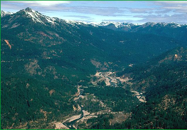
Lower Scott Mountains-Subsection M261Ak, Trinity River area above Trinity Lake Ś Scott Miles |
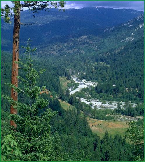
Subsection M261Ak, Castle Creek drainage Ś USDA |
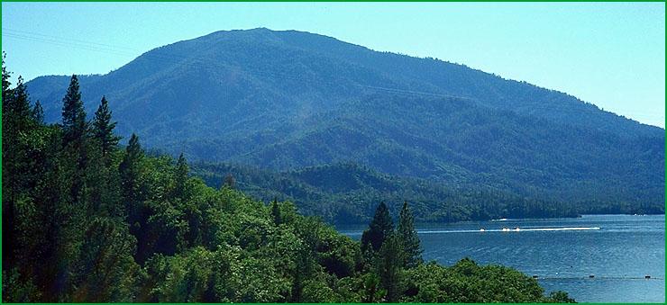
Shoemaker Bally-Subsection M261Am, Shasta Bally with Whiskeytown Lake in foreground Ś Scott Miles |
http://www.fs.fed.us/r5/projects/ecoregions/m261ak.htm
Subsection M261Ak
Lower Scott Mountains
This subsection comprises the lower elevation portion of the central part of the Eastern Klamath Belt of the Klamath Mountains. The climate is temperate and humid. MLRA 5c.
Lithology and Stratigraphy. This subsection is dominated by ultramafic rocks of the Trinity terrane, which is a complex polygenetic assemblage of disrupted Cambrian, Ordivician, Silurian, and Devonian ocean crust that has been intruded by Mesozoic granitic rocks. The terrane is represented by serpentinized peridotite, gabbro, diabase, and minor volcanic rock. The granitic rocks are generally quartz diorite to slightly more silicic rocks.
Geomorphology. This is a subsection of mountains with rounded summits, steep sides, and narrow canyons. The elevation range is about 1500 to 5000 feet. Mass wasting and fluvial erosion are the main geomorphic processes.
Soils. The soils are mostly Typic and Lithic Xerochrepts and Mollic and Ultic Haploxeralfs. Ultic Palexeralfs occur on old land surfaces. Soils on granitic rocks are mostly shallow Dystric Lithic Xerochrepts, Dystric Xerochrepts, and Ultic Haploxerolls. The soils are well drained. Soil temperature regimes are mesic. Soil moisture regimes are xeric.
Vegetation. The predominant natural plant communities are Jeffrey pine series on ultramafic rocks, Douglas-fir - ponderosa pine series on gabbro and diabase, and Mixed conifer series on granitic rocks. Canyon live oak series occurs on very steep rocky slopes with stony soils.
Characteristic series by lifeform include:
Grasslands: California annual grassland series, Purple needlegrass series.
Seeps: Darlingtonia series.
Shrublands: Brewer oak series, Greenleaf manzanita series, Wedgeleaf ceanothus series, Whiteleaf manzanita series.
Forests and woodlands: Black oak series, Canyon live oak series, Douglas-fir series, Douglas-fir - ponderosa pine series, Incense-cedar series, Jeffrey pine series, Knobcone pine series, Mixed conifer series, Oregon white oak series, Ponderosa pine series, Port Orford-cedar series.
Climate. The mean annual precipitation is about 40 to 60 inches. Most of the precipitation is rain. Mean annual temperature is about 45░ to 55░ F. The mean freeze-free period is from about 75 days at higher elevations to 175 days at lower elevations.
Surface Water. Runoff is rapid. It drains mostly to the Trinity River on the west and to the Sacramento River on the east, and a small part of the subsection drains to the Shasta River on the northeast. Larger streams are perennial and most smaller streams are dry by the end of summer. There are no natural lakes in the subsection.
Subsection M261Al
Duzel Rock
This subsection corresponds to the Yreka - Callahan area of the Eastern Klamath Belt of the Klamath Mountains. It is on the eastern edge of the Klamath Mountains, north of the Trinity Ultramafic Sheet, which is also in the Eastern Klamath Belt. The climate is temperate and subhumid. MLRAs 5d.
Lithology and Stratigraphy. This subsection contains some Cambrian plagiogranite and a variety of Cambrian through Devonian metasedimentary and minor metavolcanic rocks. They include Silurian and Devonian metamorphosed conglomerate, sandstone, shale, chert, limestone, and basalt of the Duzel, Moffett Creek, and Gazelle formations. Rocks related to the Trinity terrane occur along the western edge of the subsection, next to the Eastern Klamath Belt. Cretaceous marine sedimentary rocks of the Hornbrook Formation occur along the northern edge of the subsection, on the margin of Shasta Valley. Quaternary alluvium occurs in stream valleys.
Geomorphology. This is a subsection of mountains with rounded summits, steep sides, and narrow canyons. It is hilly, with moderately steep slopes at the northern end of the subsection and on the margin of the Shasta Valley. Floodplains and alluvial fans are most extensive in valleys of East Fork Scott River, Noyes Valley Creek, Yreka Creek, and Julien Creek. The elevation range is from about 2600 up to 6037 feet on Duzel Rock and 6098 feet on Antelope Mountain. Mass wasting and fluvial erosion are the main geomorphic processes.
Soils. The soils are mostly Typic and Lithic Argixerolls. Soils on Duzel Rock are mostly rocky Lithic Xerorthents and Lithic Haploxerolls. Ultic Haploxeralfs occur on serpentinized peridotite. Soils on alluvial fans and floodplains are mostly Xerochrepts, Argixerolls, Durixeralfs, and Endoaquolls. The soils are well drained, except for some poorly drained soils on floodplains. Soil temperature regimes are predominantly mesic, with some frigid at higher elevations.
Vegetation. The predominant natural plant communities are Western juniper series, Ponderosa pine series, Douglas-fir - ponderosa pine series, and Oregon white oak series. Jeffrey pine series occurs on serpentinized peridotite. Curlleaf mountain-mahogany is common in the western and southern parts of the subsection.
Characteristic series by lifeform include:
Grasslands: California annual grassland series.
Shrublands: Big sagebrush series, Brewer oak series, Greenleaf manzanita series, Rubber rabbitbrush series, Tobacco brush series, Wedgeleaf ceanothus series.
Forests and woodlands: Black oak series, Douglas-fir series, Douglas-fir - ponderosa pine series, Jeffrey pine series, Oregon white oak series, Ponderosa pine series, Western juniper series, White fir series.
Climate. The mean annual precipitation is about 20 to 30 inches. Most of the precipitation is rain at lower elevations, but much of it is snow at higher elevations. Mean annual temperature is about 42░ to 52░ F. The mean freeze-free period is about 75 days at higher elevations to 150 days at lower elevations.
Surface Water. Runoff is rapid. It drains to the Scott River on the west and to the Shasta River and its tributaries in the eastern part of the subsection. All but the larger streams are dry through much or most of summer. There are no natural lakes in the subsection.
Subsection M261Am
Shoemaker Bally
This subsection comprises the Shasta Bally Batholith. It is in the southwestern part of the Eastern Klamath Belt. The climate is temperate to cold and humid. MLRAs 5c, 5d, and 15d.
Lithology and Stratigraphy. This subsection is dominated by a early Cretaceous granitic pluton. The granitic rocks are generally quartz diorite to slightly more silicic rocks.
Geomorphology. This is a subsection of mountains with rounded summits, steep sides, and narrow canyons. It is between the Hoadley fault on the northeast and the Bully Choop fault on the west-southwest, although there are narrow strips of metamorphic rocks between the batholith and the faults. The elevation range is from about 1000 feet up to 6198 feet on Shasta Bally. Mass wasting and fluvial erosion are the main geomorphic processes.
Soils. The soils are mostly Typic and shallow Xerochrepts, and Ultic Haploxeralfs. Soils at higher elevations are mostly Xerumbrepts. Ultic Palexeralfs occur on older land surfaces. The soils are well drained. Soil temperature regimes are predominantly mesic, with some frigid at higher elevations and thermic adjacent to the Central Valley. Soil moisture regimes are xeric.
Vegetation. The predominant natural plant communities are Ponderosa pine series, Douglas-fir - ponderosa pine series, and Mixed conifer series, and, at higher elevations, White fir series.
Characteristic series by lifeform include:
Grasslands: California annual grassland series, Montane meadow habitat.
Shrublands: Brewer oak series, Bush chinquapin series, Chamise series, Greenleaf manzanita series, Huckleberry oak series, Tobacco brush series, Wedgeleaf ceanothus series, Whiteleaf manzanita series.
Forests and woodlands: Black oak series, Canyon live oak series, Douglas-fir series, Douglas-fir - ponderosa pine series, Foothill pine series, Interior live oak series, Knobcone pine series, Mixed conifer series, Oregon white oak series, Ponderosa pine series, Red fir series, White alder series, White fir series.
Climate. The mean annual precipitation is about 40 to 80 inches. Most of the precipitation is rain, but much of it is snow at higher elevations. Mean annual temperature is about 42░ to 56░ F. The mean freeze-free period is about 75 days at higher elevations to 200 days at lower elevations.
Surface Water. Runoff is rapid. It drains to the Trinity River on the west and to the Sacramento River and its tributaries on the east. All except the larger streams are dry through most of summer at lower elevations and part of summer at higher elevations. There no are natural lakes in the subsection.