 | Red Butte- Windy Peak-Forks of Salmon- |
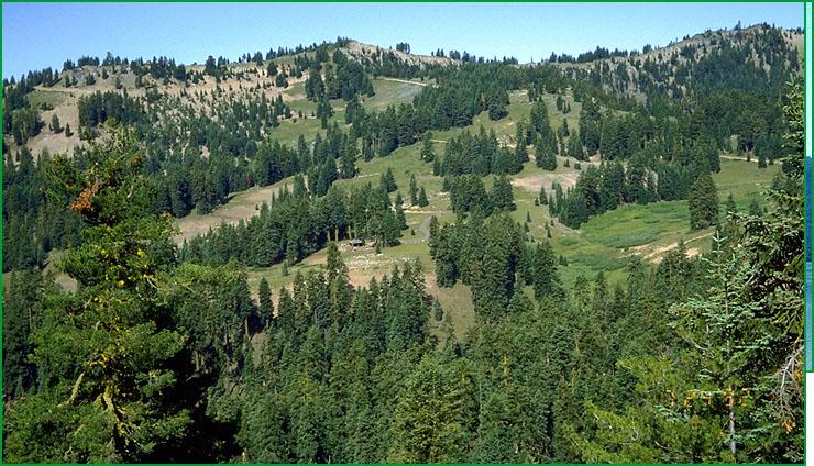
Red Butte - Subsection M261An, west of Ashland ski area Scott Miles |
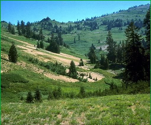
Subsection M261An, Copper Butte area Jerry Mosier |
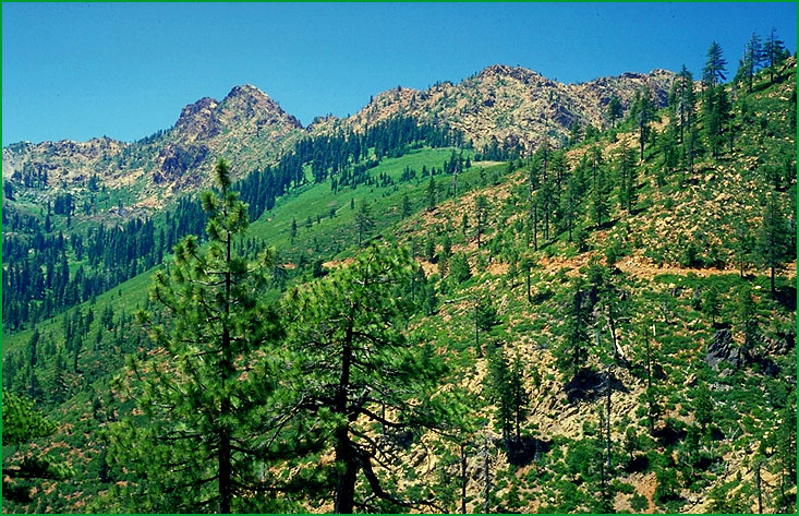
Subsection M261An, Siskiyou Crest west of Mt. Ashland Jerry Mosier |
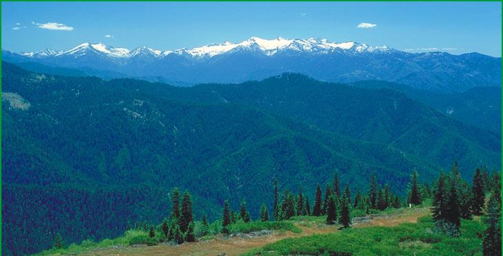
Forks of Salmon-Subsection M261Ap, looking south from Blue Ridge Mountain, Trinity Alps in background Robert Ettner |
http://www.fs.fed.us/r5/projects/ecoregions/m261an.htm
Subsection M261An
Red Butte
This subsection is along a drainage divide between the Klamath river on the south and the Applegate River on the north. It is in the Western Paleozoic and Triassic Belt. It has a cold and humid climate. MLRAs 5c and 5d.
Lithology and Stratigraphy. This subsection contains a variety of Paleozoic to Jurassic metavolcanic and metasedimentary rocks, including components of ophiolitic sequences, of Rattlesnake Creek and some Western Hayfork terranes. These older rocks were intruded by Mesozoic granitic rocks, generally quartz diorite to slightly more silicic rocks. The Condrey Mountain Schist, some of which is in this subsection, is a greenschist - blueschist facies volcanic and sedimentary sequence and subduction complex. There is some Quaternary glacial till and outwash on the north sides of the higher mountains.
Geomorphology. This is a subsection of mountains with rounded ridges, steep sides, and narrow canyons. Slopes on Condrey Mountain Schist are generally moderately steep, rather than steep, reflecting its susceptibility to mass wasting. Cirques and glaciated valleys occur on the north sides of the higher mountains. The elevation range is from about 4000 feet up to 7112 feet on Condrey Mountain. Mass wasting and fluvial erosion are the main geomorphic processes.
Soils. The soils are mostly Typic, Lithic, and Pachic Xerumbrepts and Ultic Haploxeralfs. Soil temperature regimes are predominantly frigid, with some cryic at higher elevations. Soil moisture regimes are xeric.
Vegetation. The predominant natural plant communities are White fir series, and, at higher elevations, Red fir series. Jeffrey pine series occurs on ultramafic rocks. Mixed subalpine forest series is represented in this subsection, and some unique plant communities called Enriched stands in the Klamath Mountains (Sawyer and Keeler-Wolf, 1995).
Characteristic series by lifeform include:
Grasslands: Montane meadow habitat, Subalpine meadow habitat.
Shrublands: Bush chinquapin series, Greenleaf manzanita series, Huckleberry oak series, Montane wetland shrub habitat, Montane wetland shrub habitat, Mountain heather - bilberry series, Mountain alder series, Sadler oak series, Sitka alder series, Subalpine upland shrub habitat. Subalpine wetland shrub habitat, Tobacco brush series, Wedgeleaf ceanothus series.
Forests and woodlands: Alaska yellow-cedar stands, Douglas-fir series, Incense-cedar series, Jeffrey pine series, Mountain hemlock series, Pacific silver fir stands, Red fir series, White fir series.
Climate. The mean annual precipitation is about 50 to 80 inches. Much of the precipitation is snow at lower elevations, and most of it is snow at higher elevations. Mean annual temperature is about 38¯ to 45¯ F. The mean freeze-free period is about 75 days at higher elevations to 100 days at lower elevations.
Surface Water. Runoff is rapid. It drains to the Applegate River on the north and to Indian Creek and other tributaries of the Klamath River on the south. Many of the smaller streams on the southern sides of the mountains are dry by the end of summer. There are a few lakes, or ponds, in cirque and paternoster basins
Subsection M261Ao
Windy Peak
This subsection is in the Western Paleozoic and Triassic Belt, just north of the Red Butte Subsection. It has a temperate and humid climate. MLRA 5d.
Lithology and Stratigraphy. This subsection contains a variety of Paleozoic to Jurassic metavolcanic and metasedimentary rocks, including components of ophiolitic sequences, of the Rattlesnake Creek and Applegate (Applegate terrane may be correlative with Sawyers Bar terrane) terranes. These older rocks were intruded by Mesozoic granitic rocks, generally quartz diorite to slightly more silicic rocks. The Condrey Mountain Schist, some of which is in this subsection, is a greenschist - blueschist facies volcanic sequence and subduction complex. There is some Quaternary alluvium along streams.
Geomorphology. This is a subsection of mountains with rounded ridges, steep sides, and narrow canyons. Both large and small landslides are common. Slopes on Condrey Mountain Schist are generally moderately steep, rather than steep, reflecting its susceptibility to mass wasting. There are narrow floodplains and terraces along the Applegate River and its tributaries. The elevation range is from about 1200 to 5200 feet. Mass wasting and fluvial erosion are the main geomorphic processes.
Soils. The soils are mostly Dystric and Lithic Xerochrepts and Mollic and Ultic Haploxeralfs. The soils are well drained. Soil temperature regimes are mesic. Soil moisture regimes are xeric.
Vegetation. The predominant natural plant communities are Mixed conifer series and Douglas fir - ponderosa pine series. Jeffrey pine series occurs on ultramafic rocks.
Characteristic series by lifeform include:
Grasslands: Montane meadow habitat.
Shrublands: Bush chinquapin series, Greenleaf manzanita series, Huckleberry oak series, Montane wetland shrub habitat, Montane wetland shrub habitat, Mountain alder series, Sadler oak series, Tobacco brush series, Wedgeleaf ceanothus series.
Forests and woodlands: Douglas-fir series, Douglas-fir - ponderosa pine series, Incense-cedar series, Jeffrey pine series, Ponderosa pine series, White fir series.
Climate. The mean annual precipitation is about 50 to 70 inches. Much of the precipitation is rain. Mean annual temperature is about 45¯ to 55¯ F. The mean freeze-free period is about 100 days at higher elevations to 175 days at lower elevations.
Surface Water. Runoff is rapid. It drains to the Applegate River. Many of the smaller streams are dry by the end of summer. There are no natural lakes in the subsection.
Subsection M261Ap
Forks of Salmon
This subsection is mostly in the Western Paleozoic and Triassic Belt, around the North and South Forks of the Salmon River. Some of the Central Metamorphic Belt is included in the southeast part of the subsection. The climate is temperate and humid. MLRA 5c.
Lithology and Stratigraphy. This subsection contains a variety of Paleozoic to Jurassic metavolcanic and metasedimentary rocks, including components of ophiolitic sequences, of mostly Sawyers Bar and some Western Hayfork terranes. The rocks were intruded by Mesozoic granitic rocks, generally quartz diorite to slightly more silicic rocks. Paleozoic metavolcanic rocks of the Salmon Hornblende Schist and metasedimentary and metavolcanic rocks of the Abrams Mica Schist, or Grouse Ridge Formation, occur in the southeast part of the subsection.
Geomorphology. This is a subsection of mountains with rounded ridges, steep sides, and narrow canyons. There are narrow floodplains and high terraces along the Salmon River and its tributaries. The elevation range is about 1000 to 6000 feet. Mass wasting and fluvial erosion are the main geomorphic processes.
Soils. The soils are mostly Dystric and Dystric Lithic Xerochrepts and Ultic Haploxeralfs. Soils on granitic rocks are mostly Typic Xerumbrepts. Ultic Palexeralfs occur on high terraces and other stable land surfaces. The soils are well drained. Soil temperature regimes are mesic. Soil moisture regimes are xeric.
Vegetation. The predominant natural plant communities are Douglas fir series, Douglas-fir - tanoak series, Mixed conifer series and, on the east, Douglas-fir - ponderosa pine series. Jeffrey pine series occurs on ultramafic rocks. Canyon live oak series is common on very steep rocky slopes with stony soils. Oregon white oak series occurs on clayey soils and south-facing slopes at the lower elevations.
Characteristic series by lifeform include:
Grasslands: California annual grassland series,
Shrublands: Bewer oak series, Greenleaf manzanita series, Sadler oak series, Tobacco brush series, Wedgeleaf ceanothus series.
Forests and woodlands: Black oak series, Canyon live oak series, Douglas-fir series, Douglas-fir - tanoak series, Douglas-fir - ponderosa pine series, Foothill pine series, Jeffrey pine series, Knobcone pine series, Oregon white oak series, Port Orford-cedar series, Western white pine series, White fir series.
Climate. The mean annual precipitation is about 40 to 80 inches. Most of the precipitation is rain. Mean annual temperature is about 45¯ to 56¯ F. The mean freeze-free period is about 75 days at higher elevations to 200 days at lower elevations.
Surface Water. Runoff is rapid. It drains to the Salmon River, which flows through the subsection. The larger streams are perennial and some of the smaller streams are ephemeral. There are no lakes in the subsection
Subsection M261Ao
Windy Peak
This subsection is in the Western Paleozoic and Triassic Belt, just north of the Red Butte Subsection. It has a temperate and humid climate. MLRA 5d.
Lithology and Stratigraphy. This subsection contains a variety of Paleozoic to Jurassic metavolcanic and metasedimentary rocks, including components of ophiolitic sequences, of the Rattlesnake Creek and Applegate (Applegate terrane may be correlative with Sawyers Bar terrane) terranes. These older rocks were intruded by Mesozoic granitic rocks, generally quartz diorite to slightly more silicic rocks. The Condrey Mountain Schist, some of which is in this subsection, is a greenschist - blueschist facies volcanic sequence and subduction complex. There is some Quaternary alluvium along streams.
Geomorphology. This is a subsection of mountains with rounded ridges, steep sides, and narrow canyons. Both large and small landslides are common. Slopes on Condrey Mountain Schist are generally moderately steep, rather than steep, reflecting its susceptibility to mass wasting. There are narrow floodplains and terraces along the Applegate River and its tributaries. The elevation range is from about 1200 to 5200 feet. Mass wasting and fluvial erosion are the main geomorphic processes.
Soils. The soils are mostly Dystric and Lithic Xerochrepts and Mollic and Ultic Haploxeralfs. The soils are well drained. Soil temperature regimes are mesic. Soil moisture regimes are xeric.
Vegetation. The predominant natural plant communities are Mixed conifer series and Douglas fir - ponderosa pine series. Jeffrey pine series occurs on ultramafic rocks.
Characteristic series by lifeform include:
Grasslands: Montane meadow habitat.
Shrublands: Bush chinquapin series, Greenleaf manzanita series, Huckleberry oak series, Montane wetland shrub habitat, Montane wetland shrub habitat, Mountain alder series, Sadler oak series, Tobacco brush series, Wedgeleaf ceanothus series.
Forests and woodlands: Douglas-fir series, Douglas-fir - ponderosa pine series, Incense-cedar series, Jeffrey pine series, Ponderosa pine series, White fir series.
Climate. The mean annual precipitation is about 50 to 70 inches. Much of the precipitation is rain. Mean annual temperature is about 45¯ to 55¯ F. The mean freeze-free period is about 100 days at higher elevations to 175 days at lower elevations.
Surface Water. Runoff is rapid. It drains to the Applegate River. Many of the smaller streams are dry by the end of summer. There are no natural lakes in the subsection.
Subsection M261Ap
Forks of Salmon
This subsection is mostly in the Western Paleozoic and Triassic Belt, around the North and South Forks of the Salmon River. Some of the Central Metamorphic Belt is included in the southeast part of the subsection. The climate is temperate and humid. MLRA 5c.
Lithology and Stratigraphy. This subsection contains a variety of Paleozoic to Jurassic metavolcanic and metasedimentary rocks, including components of ophiolitic sequences, of mostly Sawyers Bar and some Western Hayfork terranes. The rocks were intruded by Mesozoic granitic rocks, generally quartz diorite to slightly more silicic rocks. Paleozoic metavolcanic rocks of the Salmon Hornblende Schist and metasedimentary and metavolcanic rocks of the Abrams Mica Schist, or Grouse Ridge Formation, occur in the southeast part of the subsection.
Geomorphology. This is a subsection of mountains with rounded ridges, steep sides, and narrow canyons. There are narrow floodplains and high terraces along the Salmon River and its tributaries. The elevation range is about 1000 to 6000 feet. Mass wasting and fluvial erosion are the main geomorphic processes.
Soils. The soils are mostly Dystric and Dystric Lithic Xerochrepts and Ultic Haploxeralfs. Soils on granitic rocks are mostly Typic Xerumbrepts. Ultic Palexeralfs occur on high terraces and other stable land surfaces. The soils are well drained. Soil temperature regimes are mesic. Soil moisture regimes are xeric.
Vegetation. The predominant natural plant communities are Douglas fir series, Douglas-fir - tanoak series, Mixed conifer series and, on the east, Douglas-fir - ponderosa pine series. Jeffrey pine series occurs on ultramafic rocks. Canyon live oak series is common on very steep rocky slopes with stony soils. Oregon white oak series occurs on clayey soils and south-facing slopes at the lower elevations.
Characteristic series by lifeform include:
Grasslands: California annual grassland series,
Shrublands: Bewer oak series, Greenleaf manzanita series, Sadler oak series, Tobacco brush series, Wedgeleaf ceanothus series.
Forests and woodlands: Black oak series, Canyon live oak series, Douglas-fir series, Douglas-fir - tanoak series, Douglas-fir - ponderosa pine series, Foothill pine series, Jeffrey pine series, Knobcone pine series, Oregon white oak series, Port Orford-cedar series, Western white pine series, White fir series.
Climate. The mean annual precipitation is about 40 to 80 inches. Most of the precipitation is rain. Mean annual temperature is about 45¯ to 56¯ F. The mean freeze-free period is about 75 days at higher elevations to 200 days at lower elevations.
Surface Water. Runoff is rapid. It drains to the Salmon River, which flows through the subsection. The larger streams are perennial and some of the smaller streams are ephemeral. There are no lakes in the subsection.