 | Trinity Alps-Rattlesnake Creek- |
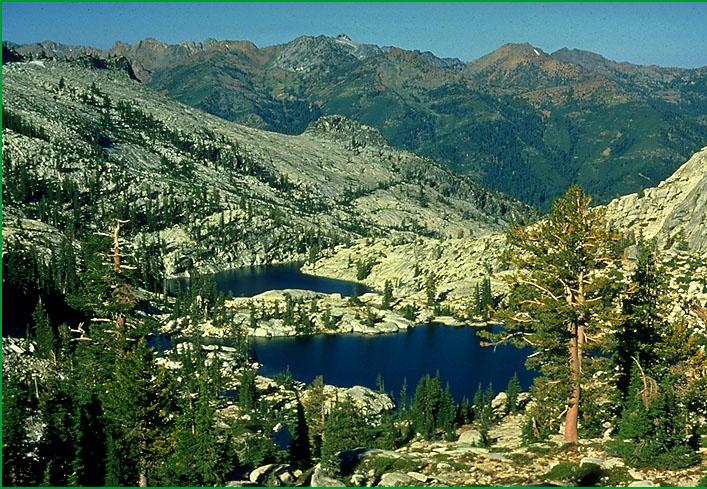
Trinity Alps-Subsection M261At, Canyon Creek Boulder lakes in the Trinity Alps Ś Wayne Steffes |
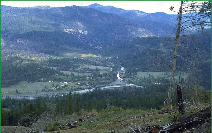
Rattlesnake Creek- Subsection M261Au, from South Fork looking up Hayfork Creek Ś Darrel Ranken |
http://www.fs.fed.us/r5/projects/ecoregions/m261at.htm
Subsection M261At
Trinity Alps
This subsection is in the higher elevation part of the Trinity Alps, in the Central Metamorphic Belt. It has a cold and humid climate. MLRAs 5c and 5d.
Lithology and Stratigraphy. This subsection is dominated by Paleozoic metavolcanic rocks of the Salmon Hornblende Schist and metasedimentary and metavolcanic rocks of the Abrams Mica Schist, or Grouse Ridge Formation, that are between the Trinity fault on the east and the Siskiyou fault on the west. The age of metamorphism is Devonian, which is when the Trinity fault was active. These older rocks were intruded by Mesozoic granitic rocks, generally quartz diorite to slightly more silicic rocks. Quaternary glacial till and outwash occur on high plateaus and occupy many valleys.
Geomorphology. This is a subsection of mountains with rounded ridges, steep sides, and narrow canyons, except at higher elevation where glaciers have carved cirques, aretes, horns, and U-shaped valleys. Glacial moraines are extensive and outwash terraces occur from moraines down-valley into adjacent subsections. The elevation range is from about 4000 feet up to 9002 feet on Thompson Peak. Mass wasting and fluvial erosion are the main geomorphic processes. Glacial processes have been prominent during the Pleistocene.
Soils. The soils are mostly Dystric Xerochrepts and Lithic, Entic, Typic, and Pachic Xerumbrepts at lower elevations. Soils at higher elevations are mostly Lithic and Typic Cryorthents and Entic and Typic Cryumbrepts. Bare rock is common at higher elevations, particularly on granitic rocks. The soils are well drained. Soil temperature regimes are frigid and cryic. Soil moisture regimes are xeric.
Vegetation. The predominant natural plant communities, from lower to higher elevations, are White fir series, Red fir series, and Mountain hemlock series. Jeffrey pine series, Foxtail pine series, and Mixed subalpine forest series occur on serpentinized peridotite. Vascular plants are absent where bedrock is exposed, except along joints that are prominent in granitic rocks.
Characteristic series by lifeform include:
Grasslands: Green fescue series, Montane meadow habitat, Nebraska sedge series, Rocky Mountain sedge series, Shorthair reedgrass series, Subalpine meadow habitat.
Seeps: Darlingtonia series.
Shrublands: Brewer oak series, Bush chinquapin series, Greenleaf manzanita series, Holodiscus series, Huckleberry oak series, Low sagebrush series, Montane wetland shrub habitat, Mountain alder series, Mountain heather - bilberry series, Sitka alder series, Subalpine upland shrub habitat, Subalpine wetland shrub habitat, Tobacco brush series, Wedgeleaf ceanothus series.
Forests and woodlands: Curlleaf mountain-mahogany series, Douglas-fir series, Douglas-fir - ponderosa pine series, Foxtail pine series, Incense-cedar series, Jeffrey pine series, Lodgepole pine series, Mixed conifer series, Mixed conifer subalpine series, Mountain hemlock series, Red fir series, Subalpine fir series, Western white pine series, White fir series, Whitebark pine series.
Climate. The mean annual precipitation is about 60 to 70 inches. Much of the precipitation is snow, and most of it is snow at higher elevations. Mean annual temperature is about 30░ to 45░ F. The mean freeze-free period is from less than 25 days at higher elevations to about 100 days at lower elevations.
Surface Water. Runoff is rapid. It drains to the Trinity River and its tributaries, except for a small area in the northwest part of the subsection which is in the South Fork Salmon watershed. Streams are mostly perennial. There are many small lakes, or ponds, in cirque and paternoster basins.
Subsection M261Au
Rattlesnake Creek
This is an arcuate subsection aligned from north-northwest to east-southeast along the southwest edge of the Klamath Mountains. It is the Western Paleozoic and Triassic Belt, bound on the southwest by the South Fork Mountain and Bear Wallow faults and on the northeast by the Salt Creek fault. The climate is temperate and humid. MLRAs 5c and 5d.
Lithology and Stratigraphy. This subsection is dominated by Paleozoic to Jurassic metavolcanic and metasedimentary rocks and serpentinized peridotite of Rattlesnake Creek terrane. These rocks are intensely faulted. There are small areas of Mesozoic granitic rocks in the subsection. There is a small area of Oligocene nonmarine sedimentary rocks of the Weaverville Formation in Hyampom Valley and Quaternary alluvium occurs there and elsewhere along the South Fork Trinity River.
Geomorphology. This is a subsection of mountains with rounded ridges, steep sides, and narrow canyons. Narrow floodplains occur along the South Fork Trinity and Trinity Rivers and are broader in Hyampom Valley. The elevation range is from about 400 feet up to 5881 feet on Dubakella Mountain. Mass wasting and fluvial erosion are the main geomorphic processes.
Soils. The soils are mostly Dystric, Dystric Lithic, Lithic, and Typic Xerochrepts and Ultic and Mollic Haploxeralfs. Soils on Lithic and Typic Xerochrepts and Mollic Haploxeralfs are on serpentinized peridotite. Shallow Dystric Xerochrepts on granitic rocks generally have paralithic contacts, rather than lithic contacts. Soils on the Weaverville formation are mostly Argixerolls and those on floodplains are mostly Xerofluvents. The soils well drained. Soil temperature regimes are mesic. Soil moisture regimes are xeric.
Vegetation. The predominant natural plant communities are Douglas-fir series, Mixed conifer series, Douglas-fir - ponderosa pine series, and Ponderosa pine series. Jeffrey pine series occurs on serpentinized peridotite. Canyon live oak series is common on very steep rocky slopes with stony soils.
Characteristic series by lifeform include:
Grasslands: California annual grassland series, Montane meadow habitat.
Shrublands: Brewer oak series, Greenleaf manzanita series, Holodiscus series, Tobacco brush series, Wedgeleaf ceanothus series.
Forests and woodlands: Black oak series, Birchleaf mountain-mahogany series, Canyon live oak series, Douglas-fir series, Douglas-fir - ponderosa pine series, Foothill pine series, Jeffrey pine series, Knobcone pine series, Mixed conifer series, Oregon white oak series, Ponderosa pine series, White alder series, White fir series.
Climate. The mean annual precipitation is about 40 to 60 inches. Most of the precipitation is rain. Mean annual temperature is about 45░ to 57░ F. The mean freeze-free period is about 100 days at higher elevations to 225 days at lower elevations.
Surface Water. Runoff is rapid. It drains to the South Fork Trinity River, except at the southeast end of the subsection where runoff drains to tributaries of the Sacramento River. All but the larger streams are dry through most of summer. There are no natural lakes in the subsection.