 | Eastern Franciscan-Central Franciscan-Stony Creek Serpentine |
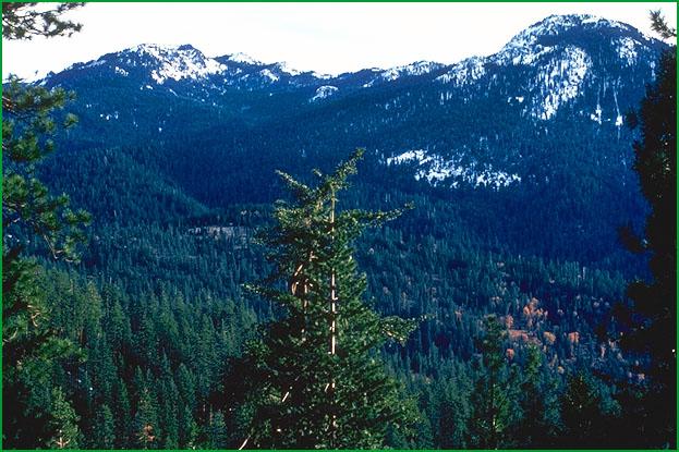
Eastern Franciscan-Black Rock Mountain area Ś Robert Ettner |
Boardman Ridge area, Mendocino National Forest Ś USDA |
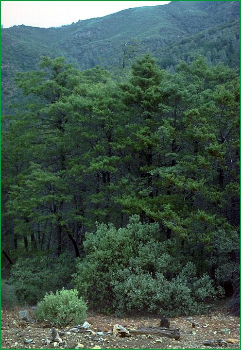
Black Butte River watershed, Etsel Ridge in background Ś Robert Ettner |
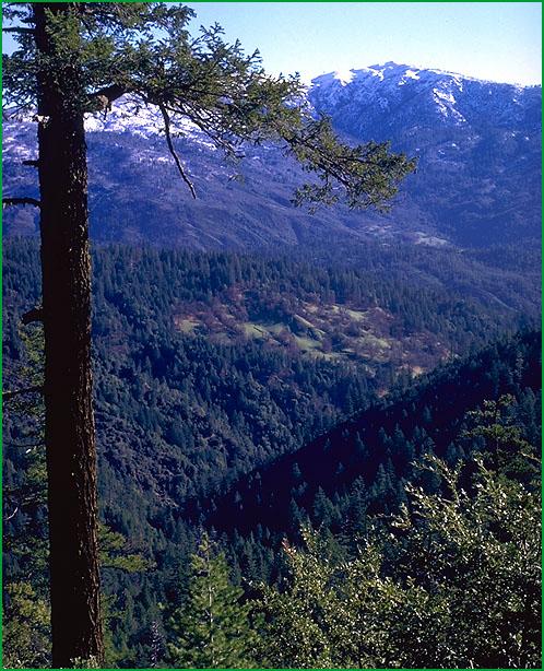
Central Franciscan -east of Alderpoint Ś David Howell |
The Geysers Ś James R. Nelson |
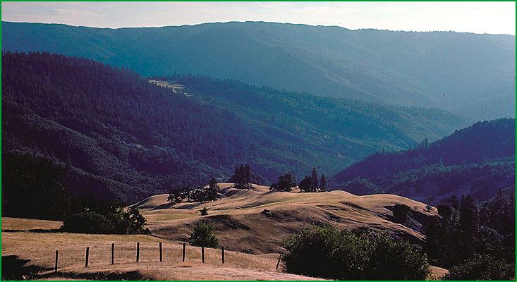
Middle Fork of Eel River area Ś Robert Ettner |
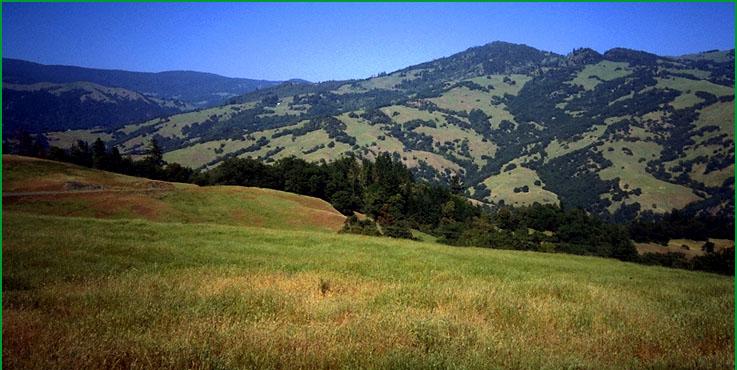
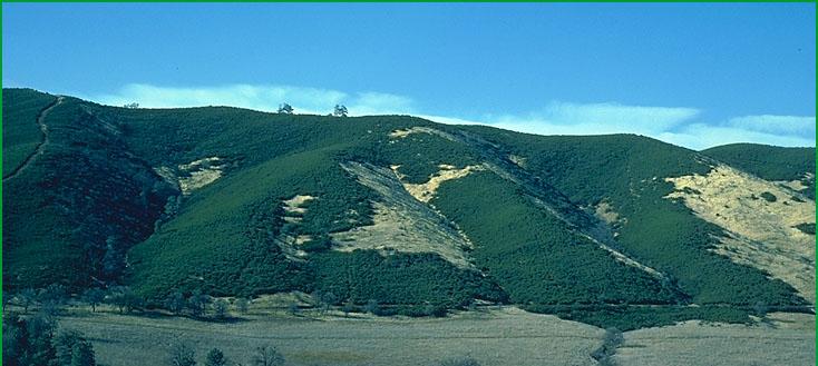
Stony Creek Serpentine-Bear Valley area showing Chamise and Chaparral Ś James R. Nelson |

http://www.fs.fed.us/r5/projects/ecoregions/m261ba.htm
Subsection M261Ba
Eastern Franciscan
This subsection is in the higher elevation part of the northern California Coast Ranges that is far enough inland to have little oceanic influence on climate. It has a temperate to cold, humid climate. MLRA 5d.
Lithology and Stratigraphy. This subsection is dominated by Jurassic and Cretaceous Franciscan metaclastic rocks of the Eastern Belt. They are intensely folded and faulted. Ultramafic rocks are minor components in this subsection.
Geomorphology. This is a subsection of mountains with rounded ridges, steep sides, and narrow canyons. Most of the mountains are elongated in north-northwest to northwest directions and have subequal summits with increasing elevation toward the interior. The elevation range is from about 1200 feet up to 8092 feet on Mt. Linn in the South Yolla Bolly Mountains. Mass wasting and fluvial erosion are the main geomorphic processes.
Soils. The soils are mostly Dystric Xerochrepts, Dystric Lithic Xerochrepts, and Lithic Xerorthents. At higher elevations, Typic and Lithic Xerumbrepts are most common. The soils are leached free of carbonates. Few surfaces are old enough, because of active erosion, to have Alfisols or Ultisols. Soil temperature regimes are predominantly mesic, some frigid, and minor cryic. Soil moisture regimes are almost exclusively xeric.
Vegetation. The predominant natural plant community is Mixed conifer series, except in the northern part of the subsection where Douglas-fir - tanoak series is the predominant plant community. Red fir series and White fir series are common in areas of frigid soil temperature regimes.
Characteristic series by lifeform include:
Grasslands: California annual grassland series, Introduced perennial grassland series, Montane meadow habitat, Rocky Mountains sedge series.
Shrublands: Brewer oak series, Bush chinquapin series, Chamise series, Chamise - wedgeleaf ceanothus series, Greenleaf manzanita series, Holodiscus series, Leather oak series, Huckleberry oak series, Interior live oak shrub series, Low sagebrush series, Montane wetland shrub habitat, Mountain alder series, Mountain whitethorn series, Rubber rabbitbrush series, Sitka alder series, Tobacco brush series, Whiteleaf manzanita series.
Forests and woodlands: Birchleaf mountain-mahogany series, California buckeye series, Canyon live oak series, Douglas-fir series, Douglas-fir - ponderosa pine series, Douglas-fir - tanoak series, Foothill pine series, Foxtail pine series, Incense-cedar series, Knobcone pine series, Jeffrey pine series, Mixed conifer series, Red fir series, White fir series.
Climate. The mean annual precipitation is about 40 to 120 inches. Most of the precipitation is rain at lower and snow at higher elevations. Mean annual temperature is about 35░ to 55░ F. The mean freeze-free period is in the range from 100 days at higher elevations to 200 days at low elevations.
Surface Water. Runoff is rapid and all but the larger streams are dry through much of the summer. There are a few small lakes and wet meadows in glacial basins at higher elevations
Subsection M261Bb
Central Franciscan
This subsection is the central part of the northern California Coast Ranges that is influenced somewhat by marine air, but lacks summer fog. It has a temperate and humid climate that is cooler during summer and wetter than the Eastern Franciscan subsection. MLRAs 5c, 5d, 14c, 14d, 15c, and 15d.
Lithology and Stratigraphy. This subsection is dominated by Jurassic and Cretaceous Franciscan graywacke, greenstone, chert, melange, and serpentinite of the Central and other Belts, and, in the southwestern part of the subsection, Cretaceous marine sedimentary rocks other than those of the Franciscan Complex. They are intensely folded and faulted. Nonmarine Pliocene sedimentary rocks are present in some low areas and Quaternary alluvium is present in the valleys.
Geomorphology. This is a subsection of mountains with rounded ridges, steep and moderately steep sides, and narrow canyons, but with several broad valleys (for example, Round Valley and Potter Valley). Most of the mountains are elongated in north-northwest to northwest directions and have subequal summits with increasing elevation toward the interior. The elevation range is from about 300 feet up to 6175 feet on Big Signal Peak. Mass wasting and fluvial erosion are the main geomorphic processes. No other part of California has a greater density (area/area) of landslides.
Soils. The soils are mostly Dystric Xerochrepts and lesser amounts of Ultic Haploxeralfs, Xerumbrepts, and Lithic Xerorthents in northern part; and predominantly Ultic Haploxerolls and lesser amounts of Haploxeralfs, Argixerolls, and Dystric Lithic Xerochrepts in the southern part of the subsection. Most of the soils are leached free of carbonates, but the subsoil is calcareous in some Xerolls. Few surfaces are old enough, because of active erosion, to have Palexeralfs, Palexerults, or Palehumults. The soil temperature regimes are predominantly mesic, but includes thermic in the southern part of the subsection. Soil moisture regimes are xeric (nearly udic or ustic).
Vegetation. The predominant natural plant communities are Douglas-fir - tanoak series with Needlegrass grasslands and Oregon white oak series in the northern part; and a mosaic of Mixed conifer series, Needlegrass grasslands, Blue oak series, and Chamise series in the southern part of the subsection. The mosaic is controlled by slope aspect, lithology, and soils. Blue oak series is most common on south-facing slopes and at lower elevations. Needlegrass grasslands are present in areas of Franciscan melange, which are quite susceptible to mass wasting by slide and flow. Chamise series prevails on south-facing slopes with shallow soils.
Characteristic series by lifeform include:
Grasslands: California annual grassland series, Introduced perennial grassland series.
Shrublands: Chamise series, Chamise - wedgeleaf ceanothus series, Interior live oak shrub series, Leather oak series, Tobacco brush series, Whiteleaf manzanita series.
Forests and woodlands: Birchleaf mountain-mahogany series, Blue oak series, California buckeye series, Canyon live oak series, Coast live oak series, Douglas-fir - tanoak series, Foothill pine series, Incense-cedar series, Interior live oak series, Knobcone pine series, Sargent cypress series, Valley oak series.
Climate. The mean annual precipitation is about 35 to 110 inches. Most of the precipitation is snow at higher and rainfall at lower elevations. Mean annual temperature is about 40░ to 58░ F. The mean freeze-free period is from 125 days at higher elevations to 250 days at lower elevations.
Surface Water. Runoff is rapid and all but the larger streams are dry by the end of the summer. Natural lakes are absent, but there are a few reservoirs in the area.
The area is widely known for extremely high sediment delivery by the streams (for example, the Eel River).
Subsection M261Bc
Stony Creek Serpentine
This subsection is a narrow strip of predominantly ultramafic and associated rocks of an ophiolite sequence that is between the Coast Range Thrust on the west and the Stony Creek Fault on the east. It has a hot, subhumid climate. MLRAs 15d and 15e.
Lithology and Stratigraphy. This subsection contains mostly Jurassic ophiolitic rocks, including peridotite, gabbro, sheeted dikes, and pillow basalt that have been altered to a melange of basalt, gabbro, and diabase in a serpentinized peridotite matrix. There are relatively small areas of Quaternary alluvium along Stony Creek and in Bear Valley.
Geomorphology. This subsection is along the steep north-trending east edge of the Northern Coast Range mountains. Most of the mountains are elongated in north-northwest to northwest directions. The elevation range is about 1200 feet to 3700 feet. Mass wasting and fluvial erosion are the main geomorphic processes.
Soils. The soils are mostly Lithic Argixerolls in serpentinitic families. Dystric Lithic Xerochrepts and Lithic Mollic Haploxeralfs are common nonserpentinitic soils. There are some Pachic Ultic Argixerolls in colluvium. Typic Pelloxererts predominate in Bear Valley. The mountain soils (excluding Bear Valley) are generally leached free of carbonates. The soil temperature regimes are predominantly thermic, but some are mesic at higher elevation and on north-facing slopes. Soil moisture regimes are almost exclusively xeric.
Vegetation. The predominant natural plant communities are Leather oak series on serpentinitic soils and Chamise series on others. In Bear Valley, the presumed potential natural plant communities are Needlegrass grasslands.
Characteristic series by lifeform include:
Grasslands: California annual grassland series.
Shrublands: Chamise series, Chamise - wedgeleaf ceanothus series, Leather oak series,
Forests and woodlands: Foothill pine series, Knobcone pine series, McNab cypress series, Sargent cypress series.
Climate. The mean annual precipitation is about 25 to 40 inches. Some of the precipitation is snow at higher elevations, but most is rainfall at lower elevations. Mean annual temperature is about 50░ to 60░ F. The mean freeze-free period is in the range from 150 days at higher elevations to 225 days at lower elevations.
Surface Water. Runoff is rapid and all but the larger streams are dry through most of the summer. Natural lakes are absent.