 | Old Cascades- Shasta Valley-Upper Shasta Valley |
Upper Shasta Valley-Subsection M261Dc, Shasta Valley area, north of Mt. Shasta Ś Julie Nelson |
Subsection M261Dc, Shasta Valley area Ś James R. Nelson |
http://www.fs.fed.us/r5/projects/ecoregions/m261da.htm
Subsection M261Da
Old Cascades
This subsection corresponds to the area of middle Tertiary volcanic rocks north of Mt. Shasta that geologists refer to as the Western Cascades. The climate is temperate and semi-arid to subhumid. MLRAs 5d and 21e.
Lithology. Eocene and Miocene andesite flows of the Western Cascades dominate this subsection. Quaternary alluvial and lacustrine basin-fill has accumulated in some areas.
Geomorphology. Steep mountain to moderately steep foothill slopes predominate in this subsection. The elevation range is from 2200 feet along the Klamath River up to about 5200 feet. Mass wasting and fluvial erosion are the main geomorphic processes, with fluvial and lacustrine deposition in Grass Lake.
Soils. Soils are mostly Andic Xerumbrepts, Lithic Xerorthents, Mollic Haploxeralfs, Vertic Argixerolls, and Leptic Haploxererts. The soils are well drained, except for poorly drained soils in basins. Soil temperature regimes are mesic. Soil moisture regimes are xeric, with some aquic in basins.
Vegetation. The predominant natural plant communities are Big sagebrush series and Oregon white oak series, with the latter most extensive north of the Klamath River and on north-facing slopes south of the Klamath River. Ponderosa pine series and Mixed conifer series occur on north-facing slopes at higher elevations. Wedgeleaf ceanothus series and Native grassland communities are common on south-facing slopes at lower elevations.
Characteristic series by lifeform include:
Grasslands: Beaked sedge series, California oatgrass series, Idaho fescue series, Nebraska sedge series, Tufted hairgrass series.
Shrublands: Big sagebrush series, Bush chinquapin series, Deerbrush series, Greenleaf manzanita series, Rubber rabbitbrush series, Tobacco brush series, Wedgeleaf ceanothus series.
Forests and woodlands: Black oak series, Douglas-fir - ponderosa pine series, Oregon white oak series, Ponderosa pine series.
Climate. The mean annual precipitation is about 15 to 25 inches. Much of the precipitation is snow. Mean annual temperature is about 45░ to 52░ F. The mean freeze-free period is about 75 to 150 days.
Surface Water. Runoff is rapid, except in basins. Water drains to the Klamath River, which crosses the subsection, or to tributaries of the Klamath River. Streams other than the Klamath and Little Shasta Rivers are dry though most of each summer.
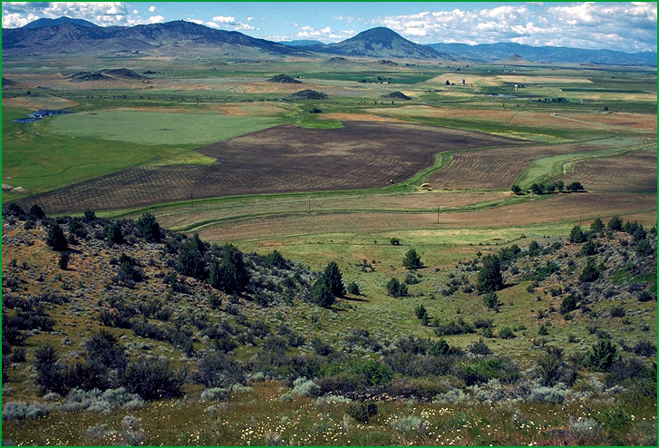
Subsection M261Db
Shasta Valley
This subsection corresponds to the lower part of Shasta Valley. It is between the Southern Cascade Mountains on the east and the Klamath Mountains on the west. The climate is temperate and semi-arid to subhumid. MLRA 21e.
Lithology and Stratigraphy. Quaternary alluvium dominates this subsection. There are a few small hills of Tertiary volcanic rocks protruding through the alluvium in the northeast and east parts of the subsection, and many small hills of Quaternary debris avalanche flow deposits on the southwest.
Geomorphology. The main landforms are nearly level to moderately sloping floodplains, terraces, and alluvial fans. There are many small, moderately sloping to moderately steep hills on the alluvial plain. The elevation range is about 2600 to 3000 feet. Fluvial erosion and deposition, and freeze-thaw are the main geomorphic processes.
Soils. Soils are mostly Typic Durixeralfs and Palexerollic Durixerolls, with Fluvaquentic Haploxerolls, Fluvaquentic Endoaquolls, and Aquic Durorthids on floodplains and terraces. The soils are mostly well drained on alluvial fans and somewhat poorly to poorly drained on floodplains and terraces. Soil temperature regimes are mesic. Soil moisture regimes are aridic, xeric, and aquic.
Vegetation. The predominant natural plant communities are Big sagebrush series, Western juniper series, and Sedge meadow communities.
Characteristic series by lifeform include:
Grasslands: Beaked sedge series, California oatgrass series, Idaho fescue series, Nebraska sedge series, Sedge series, Tufted hairgrass series.
Shrublands: Big sagebrush series, Low sagebrush series, Rubber rabbitbrush series, Wedgeleaf ceanothus series.
Forests and woodlands: Black oak series, Western juniper series.
Climate. The mean annual precipitation is about 8 to 18 inches. Much of the precipitation is snow. Mean annual temperature is about 50░ to 52░ F. The mean freeze-free period is about 125 to 150 days.
Surface Water. Runoff is moderately rapid from alluvial fans and slow to very slow from floodplains and terraces. Water drains to the Little Shasta and Shasta Rivers, which are perennial streams through the subsection
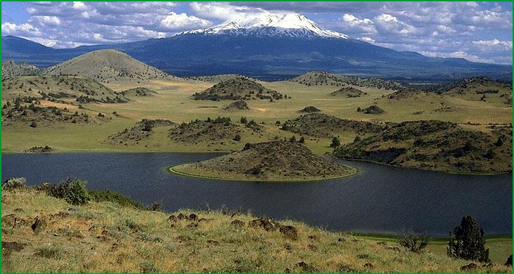
Subsection M261Dc
Upper Shasta Valley
This subsection corresponds to the upper part of Shasta Valley. It is just northwest of Mt. Shasta. The climate is temperate and semi-arid to subhumid. MLRA 21e.
Lithology and Stratigraphy. Quaternary debris avalanche flow deposits and alluvium dominate the western part and Quaternary basalt flows dominate the eastern part of this subsection. There is some Pleistocene glacial till and outwash from Mt. Shasta on the southeastern edge of the subsection.
Geomorphology. The main landforms are undulating lava flows on the east and moderately steep to steep hills consisting of large colluvial blocks of rock on the west with very gently to moderately sloping pediments and alluvial fans on finer colluvial debris between hills. Colluvial blocks in landforms on the west side of the subsection slid or flowed off of a predecessor of Mt. Shasta about 0.3 million years ago, coming to rest among disrupted alluvial deposits. There are many closed basins among the hills of the debris avalanche flow deposits. Floodplains and terraces are most extensive along Parks and Willow Creeks and alluvial fans are most extensive on the southwest edge of the subsection, adjacent to the Klamath Mountains. The elevation range is about 2600 to 4000 feet. Volcanic lava flow, mass wasting, fluvial erosion and deposition, and freeze-thaw are the main geomorphic processes.
Soils. Soils are mostly rocky Typic Durixeralfs on lava flows; Typic Xeropsamments on glacial outwash and alluvial fans adjacent to Mt. Shasta; rocky Lithic Haploxerolls on debris flow blocks; Mollic Haploxeralfs, Vertic Argixerolls, and Leptic Haploxererts on finer debris flow deposits, pediments, and alluvial fans around the debris flow blocks; Xeric Endoaquerts and Aquic Durorthids in basins among debris flow deposits; and Typic Xerochrepts and Pachic Argixerolls on alluvial fans adjacent to the Klamath Mountains. Fluvaquentic Haploxerolls and Fluvaquentic Endoaquolls occur on floodplains along Parks and Willow Creeks and Palexerollic Durixerolls occur on terraces with mima mounds near Parks Creek. The soils are mostly well drained, except somewhat poorly to poorly drained soils on floodplains and in basins. Soil temperature regimes are mesic. Soil moisture regimes are aridic, xeric, and aquic.
Vegetation. The predominant natural plant communities are Big sagebrush series and Native grassland communities, with Western juniper series on the east, and Sedge meadow communities on floodplains and in basins. Low sagebrush series occurs on shallow soils with silica hardpans.
Characteristic series by lifeform include:
Grasslands: Beaked sedge series, California oatgrass series, Idaho fescue series, Nebraska sedge series, Sedge series, Tufted hairgrass series.
Shrublands: Big sagebrush series, Low sagebrush series, Rubber rabbitbrush series, Wedgeleaf ceanothus series.
Forests and woodlands: Black oak series, Ponderosa pine series, Western juniper series.
Climate. The mean annual precipitation is about 12 to 25 inches. Much of the precipitation is snow. Mean annual temperature is about 48░ to 52░ F. The mean freeze-free period is about 100 to 150 days.
Surface Water. Runoff is rapid from hills and slow from alluvial fans and floodplains. The drainage systems are poorly integrated on lava flows on the east and on debris avalanche flow deposits on the west. There are few streams, especially on the lava flows. The Shasta River and Parks and Willow Creeks flow through the subsection. Ephemerally ponding occurs in closed basins of the debris avalanche flow terrain.