 | McCloud Flat-Medicine Lake Lava Flows-Medicine Lake Highlands-Hat Creek Rim |
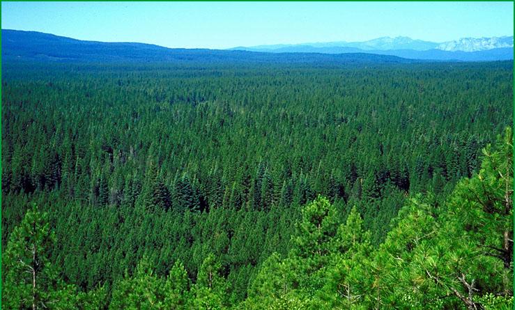
McCloud Flat-Subsection M261Dg, McCloud Flat from McIntosh Vista Ś Scott Miles |
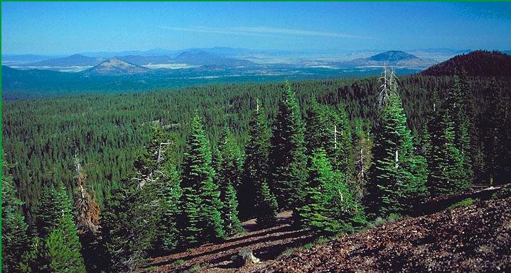
Medicine Lake Lava Flows-Subsection M261Dh, view northward from Little Mt. Hoffman Ś Robert Ettner |
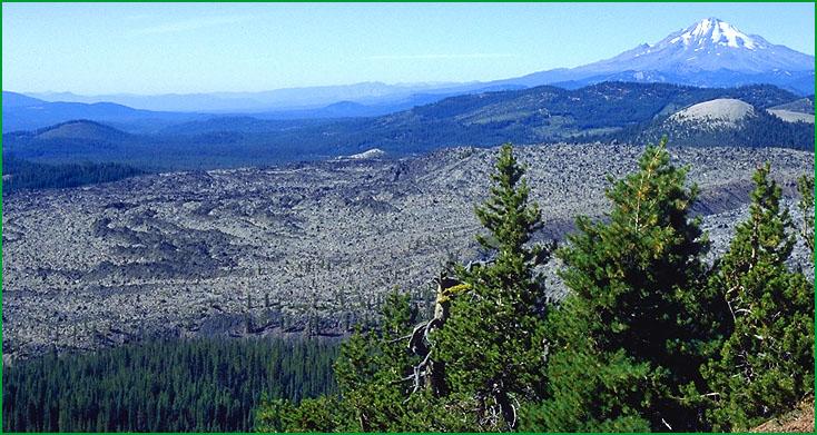
Medicine Lake Highlands-Subsection M261Di, view eastward from Little Mt. Hoffman Ś Scott Miles |
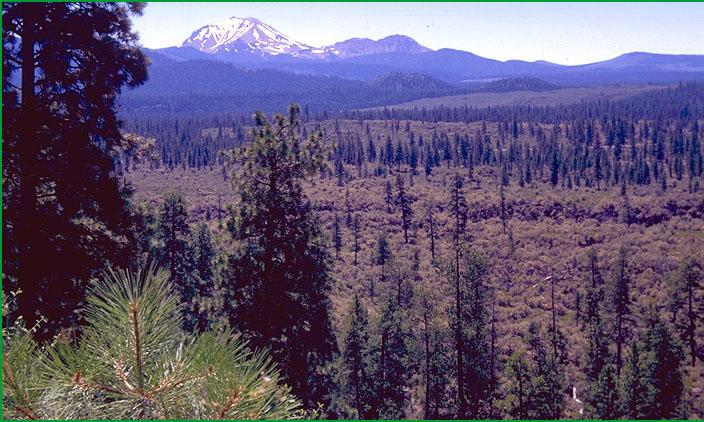
Hat Creek Rim-Subsection M261Dj, Hat Creek lava flows, Mt. Lassen in background Ś Scott Miles |
http://www.fs.fed.us/r5/projects/ecoregions/m261dg.htm
Subsection M261Dg
McCloud Flat
This subsection is a volcanic plain that lies on the southeastern flank of Mt. Shasta. It is bordered on the south by the McCloud River. The climate is temperate and humid. MLRA 22c.
Lithology and Stratigraphy. Pliocene basalt flows dominate the subsection. They are deeply buried by Quaternary alluvium near the flanks of Mt. Shasta. The basalt flows are largely covered by alluvium in the middle of the subsection, and they are exposed near the McCloud River.
Geomorphology. The dominant landform is undulating basalt flows which have been faulted to form horsts and grabbens. Alluvial plains have formed in depressions in the grabbens. Gently sloping mudflow deposits, glacial deposits, and alluvial fans emanating from Mt. Shasta overlie the basalt flows on the west and northwest margins of the subsection. The center of the subsection is characterized by a terrain of small areas of alluvium with frequent basalt rock outcrops. The basalt flows are gradually more exposed closer to the McCloud River. The elevation range is 3000 to 4000 feet. Volcanic and fluvial processes predominate.
Soils. Soils on the rocky volcanic plateau are mostly Lithic Xerumbrepts, Umbric Vitrixerands, and Humic Haploxerands. Soils on alluvium in closed basins on the volcanic Plateau are mostly Vitrandic and Andeptic Xeropsamments, Typic and Umbric Vitrixerands, and Entic Xerumbrepts. Soils on alluvium and colluvium around the base of Mt. Shasta are mostly Andic Xerumbrepts and Typic and Humic Haploxerands. The soils are well drained. Soil temperature regimes are mesic. Soil moisture regimes are xeric.
Vegetation. The predominant natural plant communities are mostly Ponderosa pine series on the volcanic plateau and, from lower to higher elevations on alluvial fans and mudflows from Mt. Shasta, Ponderosa pine series, Mixed conifer series, and White fir series. Lodgepole pine series occurs along drainage-ways and cold air basins on the volcanic plateau.
Characteristic series by lifeform include:
Grasslands: Beaked sedge series, Idaho fescue series, Nebraska sedge series, Sedge series, Tufted hairgrass series.
Shrublands: Deerbrush series, Greenleaf manzanita series, Huckleberry oak series, Mountain whitethorn series, Tobacco brush series, Wedgeleaf ceanothus series.
Forests and woodlands: Black oak series, Douglas-fir series, Incense-cedar series, Lodgepole pine series, Knobcone pine series, Mixed conifer series, Ponderosa pine series, White fir series.
Climate. The mean annual precipitation is about 40 to 60 inches. Much of the precipitation is snow. Mean annual temperature is about 45░ to 50░ F. The mean freeze-free period is about 100 to 150 days.
Surface Water. Runoff is rapid. Water drains down through joints in basalt to the ground water reservoir, limiting overland flow of water and development of stream channels. Some streams flowing from Mt. Shasta, such as Mud Creek and Ash Creek, are perennial. Ash Creek infiltrates into Ash Creek Sink. Mud Creek is tributary to the McCloud River
Subsection M261Dh
Medicine Lake Lava Flows
This subsection is a volcanic plateau surrounding the Medicine Lake Highlands on all but the west side, where it is bounded by the High Cascades. The climate is temperate to cold and semi-arid to subhumid. MLRA 22c.
Lithology and Stratigraphy. Pliocene, Pleistocene, and Recent basalt flows dominate this subsection. Much of the Recent basalt has flowed from the still active Medicine Lake volcano in the Medicine Lake Highlands and from fissures around the volcano. Pliocene nonmarine sedimentary rocks are common just south of the Lower Klamath Lake and Tule Lake basins. Recent cinders and ash are scattered across the subsection. Quaternary alluvium occurs in small basins between lava flows and in very small basins on flows.
Geomorphology. The dominant landform is an undulating basalt plain that is interrupted by many moderately steep to steep volcanic domes and cinder cones. Major faults are aligned toward the north or north-northwest. Much of the related horst and grabben pattern is buried by recent lava flows. The recent lava flows generally have rough, broken surfaces. The elevation range is from about 4100 to 6500 feet. Volcanic, tectonic, fluvial, and freeze-thaw processes predominate.
Soils. Soils are mostly Lithic, Typic, and Duric Vitritorrands; Lithic and Humic Haploxerands; and, in basins, Andic Xerumbrepts. Rock and rubbleland predominate on Recent lava flows. Soils on Pliocene sedimentary rocks are mostly Aridic Argixerolls and Pachic Haploxerolls. The soils are well drained. Soil temperature regimes are mesic, with some frigid. Soil moisture regimes are aridic and xeric.
Vegetation. The predominant natural plant communities are mostly Western Juniper series, Big sagebrush series, and Native grassland communities in drier areas and Ponderosa pine series in areas of higher precipitation. Curlleaf mountain-mahogany occurs on shallow and rocky soils. Mixed conifer series occurs in the southern part and Lodgepole pine series in the northern part of the subsection. Most of the Recent lava flows are barren, lacking vascular plants.
Characteristic series by lifeform include:
Grasslands: Beaked sedge series, Idaho fescue series, Nebraska sedge series, Sedge series, Tufted hairgrass series.
Shrublands: Big sagebrush series, Bitterbrush series, Low sagebrush series, Rubber rabbitbrush series.
Forests and woodlands: Knobcone pine series, Ponderosa pine series, Western juniper series.
Climate. The mean annual precipitation is about 10 to 30 inches. Much of the precipitation is snow. Mean annual temperature is about 40░ to 48░ F. The mean freeze-free period is about 75 to about 125 days.
Surface Water. Runoff is moderately rapid. Water drains down through joints in basalt to the ground water reservoir, limiting overland flow of water and development of stream channels on the volcanic plateau. There are few streams and many small, closed basins in the subsection. Ephemeral ponding occurs in some of the basins that are in grabens
Subsection M261Di
Medicine Lake Highlands
This subsection is a volcanic highland around the remnants of a very large shield volcano. The climate is cold and subhumid. MLRA 22c.
Lithology and Stratigraphy. Pliocene and Pleistocene basalt and andesite flows and Recent basalt, andesite, and rhyolite, including obsidian, flows and pyroclastic deposits dominate this subsection.
Geomorphology. The Medicine Lake Highlands are built of Pleistocene and Recent lava flows and pyroclastic deposits on a Pleistocene shield volcano. The center of the shield volcano collapsed and volcanoes around the rim of the crater have partially filled and obliterated it. Slopes range from steep on some volcanoes to gentle on basalt and andesite lava flows. The terrain is rough and chaotic on recent lava flows. There are many cinder cones in the subsection. Basin-fill has accumulated in the crater occupied by Medicine Lake. The elevation range is from about 4500 up to 7913 feet on Mt. Hoffman. Volcanic and fluvial processes predominate.
Soils. Soils are mostly Lithic and Vitrandic Xerorthents and Typic and Humic Haploxerands. Thaptic Vitrixerands occur in Recent pumice deposits. Rock and rubbleland predominate on many Recent lava flows. The soils are well drained. Soil temperature regimes are mostly frigid, with some cryic and mesic. Soil moisture regimes are xeric.
Vegetation. The predominant natural plant communities are Red fir series and White fir series, and, in cold valleys and basins, Lodgepole pine series. Mountain hemlock series occurs at the higher elevations. Mixed conifer series and Ponderosa pine series occur at the lower elevations. Many Recent lava flows are barren, lacking vascular plants.
Characteristic series by lifeform include:
Grasslands: Beaked sedge series, Green fescue series, Idaho fescue series, Nebraska sedge series, Rocky Mountain sedge series, Sedge series, Tufted hairgrass series.
Shrublands: Big sagebrush series, Bush chinquapin series, Greenleaf manzanita series, Mountain heather - bilberry series, Mountain whitethorn series, Parry rabbitbrush series, Rubber rabbitbrush series, Tobacco brush series.
Forests and woodlands: Black oak series, Knobcone pine series, Lodgepole pine series, Mixed subalpine forest series, Mountain hemlock series, Ponderosa pine series, Red fir series, Western White pine series, White fir series.
Climate. The mean annual precipitation is about 25 to 40 inches. Most of the precipitation is snow. Mean annual temperature is about 35░ to 45░ F. The mean freeze-free period is about 25 to 100 days.
Surface Water. Runoff is rapid. Water drains down through cinders, pumice, and joints in basalt to the ground water reservoir, limiting overland flow of water and development of stream channels on the volcanic plateau. There are few streams in the subsection, and they are ephemeral, flowing to closed basins. Medicine Lake is in the crater of ancient Mt. Hoffman
Subsection M261Dj
Hat Creek Rim
This subsection corresponds to a relatively low and narrow part of the Southern Cascade Range from Hat Creek Rim and Hat Creek valley north to the Bear Creek area near Pondosa. The climate is temperate to cold and subhumid to humid. MLRA 22d.
Lithology and Stratigraphy. Miocene, Pliocene, and Pleistocene basalt and andesite lava flows dominate this subsection. Quaternary basalt lava flows occur on Cinder Cone, Cinder Butte, and the floor of Hat Creek Valley. Weakly consolidated Pliocene and Quaternary sedimentary deposits, including diatomite, occur along the Pit River in the vicinity of Lake Britton. Quaternary alluvial and lacustrine basin-fill has accumulated in some valleys.
Geomorphology. Very gently to moderately sloping lava flows predominate, with steep risers between these lava flow surfaces and steep canyons cut through the flows. Slopes are very steep in the inner gorge of the Pit River and nearly level on basin floors such as those in Goose Valley, along Burney Creek, and on Cayton Flat. The terrain is rough and chaotic on recent lava flows. There are some cinder cones in the subsection, mostly in Hat Creek Valley, which is a graben, and near the plateau rim on the east side of the graben. The graben and most of the major faults are aligned toward the north-northwest. Some large landslides caused by failure of diatomaceous sediments occur on the north side of the Pit River. The elevation range is from about 2400 feet along the Pit River up to 5540 feet on Soldier Mountain and 5733 on Red Mountain. Tectonic, volcanic, and fluvial processes predominate. Mass wasting is common below the Hat Creek Rim, along the Soldier Mountain fault-line scarp, and along the Pit River.
Soils. Soils, from lower to higher elevations, are mostly Vitrandic Argixerolls, Vitrandic Palexeralfs, Andic Palehumults, Ultic Haploxerands, Humic Haploxerands, and Melanoxerands. Haploxeralfs, Haplohumults, and Haploxerands are common on steep slopes. Rock and rubbleland predominate on recent lava flows. Cumulic Humaquepts and Vertic Haplaquolls occur in basin floors. The soils are well drained, except poorly drained soils on basin floors. Soil temperature regimes are mostly mesic, with some frigid. Soil moisture regimes are xeric, except aquic on basin floors.
Vegetation. The predominant natural plant communities, from lower to higher elevations, are generally Oregon white oak series, Ponderosa pine series, Mixed conifer series, and White fir series. Birchleaf mountain-mahogany series and Wedgeleaf ceanothus series occur on shallow soils at lower elevations. Recent lava flows are barren or sparsely to densely vegetated by vascular plants, which includes Greenleaf manzanita series and some Curlleaf mountain-mahogany series. Western juniper series and Big sagebrush series occur in drier areas along the eastern edge of the subsection.
Characteristic series by lifeform include:
Grasslands: Beaked sedge series, Idaho fescue series, Nebraska sedge series, Rocky Mountain sedge series, Sedge series, Tufted hairgrass series.
Shrublands: Big sagebrush series, Bitterbrush series, Bush chinquapin series, Deerbrush series, Greenleaf manzanita series, Huckleberry oak series, Mountain whitethorn series, Rubber rabbitbrush series, Tobacco brush series, Wedgeleaf ceanothus series.
Forests and woodlands: Birchleaf mountain-mahogany series, Black oak series, Blue oak series, Curlleaf mountain-mahogany series, Douglas-fir series, Incense-cedar series, Interior live oak series, Oregon white oak series, Ponderosa pine series, Mixed conifer series, Western juniper series, White fir series.
Climate. The mean annual precipitation is about 20 to 60 inches. Most of the precipitation is snow. Mean annual temperature is about 45░ to 55░ F. The mean freeze-free period is about 75 to 150 days.
Surface Water. Runoff is rapid, except on basin floors. Water drains down through joints in basalt on Recent lava flows, limiting overland flow of water and development of stream channels on these younger flows. Some larger streams, particularly Hat Creek, are perennial. Most of the smaller streams are ephemeral, being dry during summer. Streams flow to the Pit River or its tributaries, except at the northern end of the subsection which is in the McCloud River drainage system.