 | Parker Mountain Flat-Shingletown - Paradise-Lassen - Almanor |
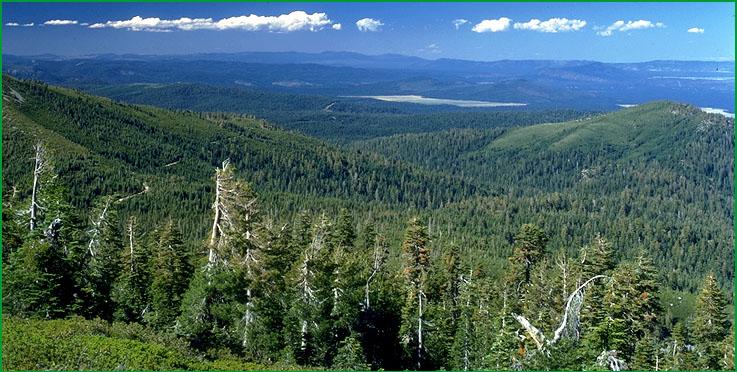
Shingletown - Paradise-Subsection M261Dl, Snow Mountain area southwest of Burney Ś Robert Ettner |
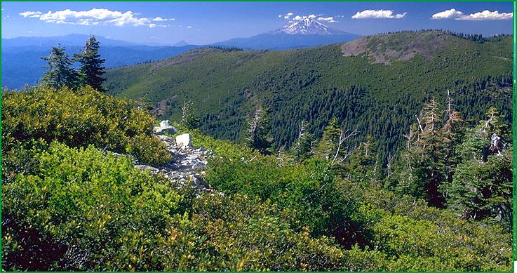
Subsection M261Dl, Mt. Shasta from Snow Mountain Ś Robert Ettner |
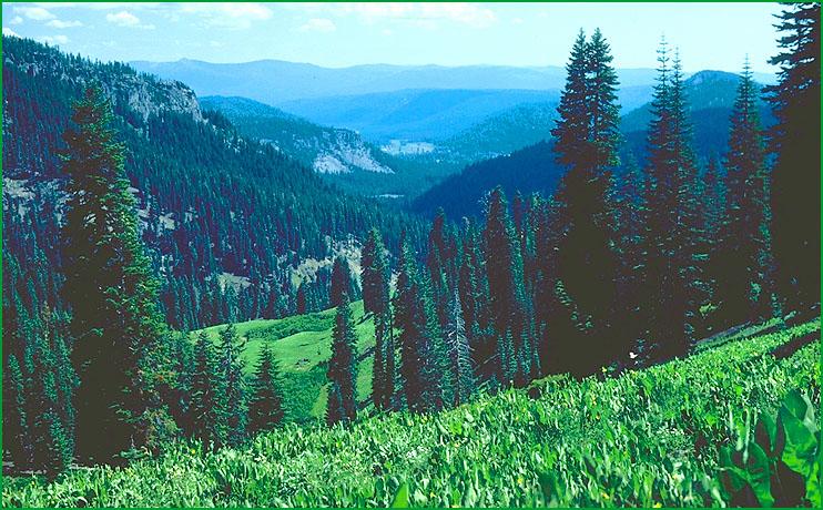
Lassen - Almanor-Subsection M261Dm, view south from Mt. Lassen area Ś Robert Ettner |
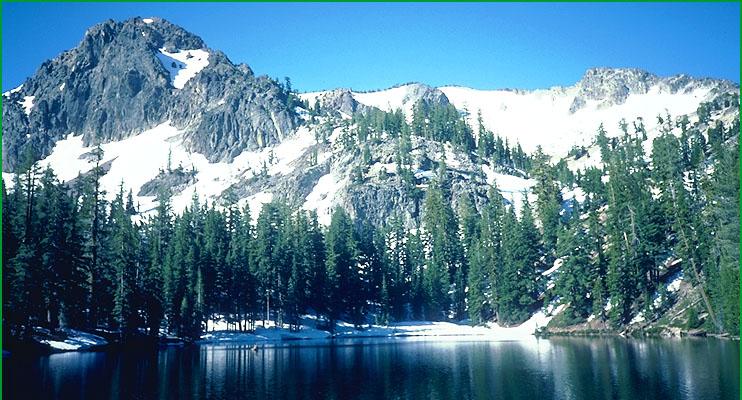
Subsection M261Dm, Thousand Lakes Wilderness Ś James R. Nelson |
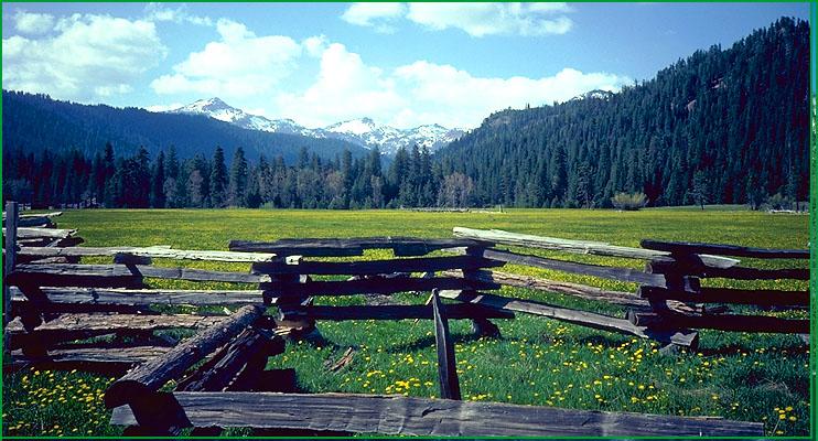
Subsection M261Dm, Childs Meadows Ś James R. Nelson |
http://www.fs.fed.us/r5/projects/ecoregions/m261dk.htm
Subsection M261Dk
Parker Mountain Flat
This subsection comprises a volcanic plateau north of the Klamath River and just west of the High Cascades. The climate is temperate and humid. MLRA 5d.
Lithology and Stratigraphy. Upper Miocene and Pliocene basalt and andesite lava flows and flow breccias dominate this subsection. Pliocene and Quaternary pyroclastic deposits and Quaternary basalt lava flows are less extensive.
Geomorphology. This subsection is on a rolling volcanic plateau with gentle to moderately steep slopes. The elevation range is from about 3400 feet just above the canyon of the Klamath River up to 5112 feet on Grizzly Mountain and 5210 feet on Parker Mountain. Volcanic and fluvial erosion processes predominate.
Soils. Soils are mostly Lithic, Vertic, and Ultic Argixerolls at lower elevations and Ultic Haploxeralfs at higher elevations. Andic Xerumbrepts occur on north-facing slopes at higher elevations. Rubbleland is extensive. The soils are well drained. Soil temperature regimes are mostly mesic, with some frigid. Soil moisture regimes are xeric.
Vegetation. The predominant natural plant communities are Wedgeleaf ceanothus and Native grassland communities on shallow and clayey soils, and Ponderosa pine series on Pachic Ultic Argixerolls at lower elevations, and Mixed conifer series on Ultic Haploxeralfs. Some Oregon white oak series occurs on north-facing slopes at lower elevations. White fir series occurs on north-facing slopes at higher elevations.
Characteristic series by lifeform include:
Grasslands: Beaked sedge series, California oatgrass series, Idaho fescue series, Nebraska sedge series, Tufted hairgrass series.
Shrublands: Big sagebrush series, Low sagebrush series, Rubber rabbitbrush series, Wedgeleaf ceanothus series.
Forests and woodlands: Black oak series, Douglas-fir series, Incense-cedar series, Ponderosa pine series, Mixed conifer series, Oregon white oak series, White fir series.
Climate. The mean annual precipitation is about 30 to 40 inches. Much of the precipitation is snow. Mean annual temperature is about 45░ to 50░ F. The mean freeze-free period is about 75 to 125 days.
Surface Water. Runoff is rapid. Most of the streams are ephemeral, being dry during summer. Streams flow to the Klamath River or its tributaries.
Subsection M261Dl
Shingletown - Paradise
This subsection comprises volcanic mountains and plateaus between the High Cascades and the lower part of the Tuscan volcanic plateau southwest of Lassen Peak. The climate is temperate and humid. MLRA 22c.
Lithology and Stratigraphy. Pliocene and Pleistocene basalt and andesite lava flows and andesitic lahars dominate this subsection. Rhyolite lava flows and silicic pyroclastic deposits are much less extensive. Pleistocene glacial outwash and Recent alluvium occupy stream valleys and basins.
Geomorphology. Steep mountains, moderately steep hills, and very gently to moderately sloping, deeply dissected plateaus are all major landscape components. There are few cinder cones. The elevation range is about 2000 to 5000 feet, and up to 5496 feet on Hatchet Mountain. Volcanic and fluvial processes predominate. Mass wasting is important on steep mountains and canyon sideslopes.
Soils. Soils are mostly Ultic Palexeralfs at lower elevations, Xeric Haplohumults at intermediate elevations, Andic Haplohumults at higher elevations, and Andic Xerumbrepts on late Quaternary lava flows, glacial outwash, and steep slopes. The soils are well drained. Soil temperature regimes are mostly mesic, with some frigid. Soil moisture regimes are xeric.
Vegetation. The predominant natural plant communities are, from lower to higher elevations, Ponderosa pine series, Mixed conifer series, and White fir series. Canyon live oak series occurs on very steep canyon sideslopes.
Characteristic series by lifeform include:
Grasslands: Beaked sedge series, California oatgrass series, Idaho fescue series, Nebraska sedge series, Tufted hairgrass series.
Shrublands: Brewer oak series, Buttonbush series, Deerbrush series, Greenleaf manzanita series, Interior live oak shrub series, Mulefat series, Scrub oak series, Whiteleaf manzanita series.
Forests and woodlands: Black oak series, Blue oak series, Canyon live oak series, Douglas-fir series, Foothill pine series, Incense-cedar series, Interior live oak series, Knobcone pine series, McNab cypress series, Oregon white oak series, Ponderosa pine series, Mixed conifer series, White alder series, White fir series, White oak series.
Climate. The mean annual precipitation is about 30 to 60 inches, but over 90 inches on Snow and Clover Mountains. Much of the precipitation is snow. Mean annual temperature is about 46░ to 58░ F. The mean freeze-free period is about 100 to 175 days.
Surface Water. Runoff is moderately rapid. Water drains down through joints in basalt on Recent lava flows, but the lahars are aquitards. The larger streams, including Cow Creek, Battle Creek, Paynes Creek, Antelope Creek, and Deer Creek, are perennial. Most of the smaller streams are ephemeral, being dry during summer. Streams flow to the Pit River or the Sacramento River.
Subsection M261Dm
Lassen - Almanor
This subsection comprises the High Cascades at the southern end of the Southern Cascade Ranges. The climate is cold to very cold and humid. MLRA 22d.
Lithology and Stratigraphy. Pliocene and Pleistocene basalt and andesite lava flows and pyroclastic deposits dominate this subsection. Rhyolite and dacite lava flows and andesitic lahars are less extensive. Pleistocene glacial till and outwash are extensive and Recent alluvial and lacustrine deposits occupy stream valleys and basins.
Geomorphology. Moderately steep to steep shield and composite volcanoes, plug domes, and cinder cones, surrounded by volcanic plateau, dominate the subsection. Cinder cones are most numerous north-northwest of Lassen Peak and on the northeastern part of the plateau east of Lassen Peak. Glacial ice covered the higher peaks and much of the plateau just east of Lassen Peak during the Pleistocene. Lassen Peak has been sufficiently active since the Recent Epoch to obliterate most of the glacial features on and immediately around it. Glacial deposits are most extensive on the southeast edge of the plateau east of Lassen Peak, where there has been less Recent volcanic activity. The elevation range is from about 4500 feet around Lake Almanor up to 10,457 feet on Lassen Peak. Volcanic, mass wasting, glacial, and fluvial processes predominate.
Soils. Soils are mostly Andic Xerumbrepts, Haploxerands, Typic Haplocryands, and Typic Vitrixerands. Ultic Argixerolls and Ultic Haploxeralfs predominate on uplands around Lake Almanor. Cumulic Humaquepts occur on wet floodplains and basin floors. The soils are well drained, except poorly drained soils on floodplains and in basins. Soil temperature regimes are mostly frigid and cryic. Soil moisture regimes are xeric, except aquic on floodplains and in basins.
Vegetation. The predominant natural plant communities are, from lower to higher elevations, White fir series, Red fir series, Mountain hemlock series, and Whitebark pine series. Jeffrey pine - ponderosa pine series is common east of Lassen Peak. Lodgepole pine series occurs in cold basins. Barren land and Alpine habitat occurs at higher elevations.
Characteristic series by lifeform include:
Grasslands: Alpine habitat, Beaked sedge series, Green fescue series, Nebraska sedge series, Rocky Mountain sedge series, Tufted hairgrass series.
Shrublands: Big sagebrush series, Bitterbrush series, Bush chinquapin series, Greenleaf manzanita series, Huckleberry oak series, Mountain heather - bilberry series, Mountain whitethorn series, Parry rabbitbrush series, Tobacco bush series.
Forests and woodlands: Black oak series, Jeffrey pine series, Jeffrey pine - ponderosa pine series, Lodgepole pine series, Mixed subalpine forest series, Mountain hemlock series, Ponderosa pine series, Red fir series, Western white pine series, White fir series, Whitebark pine series.
Climate. The mean annual precipitation is about 40 to 60 inches, but over 80 inches around Lassen Peak and just south of it. Most of the precipitation is snow. Mean annual temperature is about 30░ to 45░ F. The mean freeze-free period is from less than 25 to about 100 days.
Surface Water. Runoff is mostly rapid, but slow from floodplains and basins. Hydrothermal activity is common around Lassen Peak. There are many perennial ponds in the glacial till on the plateau east of Lassen Peak, and some ponds around Lassen Peak were created by landslides. The subsection, around Lassen Peak, is a hub of drainage divides, with streams flowing eastward to closed basins of the Modoc Plateau and the Great Basin, southward to the Feather River, westward to the Sacramento River, and northward to the Pit River. Lake Almanor is in a former lake basin at the head of the North Fork of the Feather River that has been dammed to raise the lake level.