 | Diamond Mountain - Crystal Peak-Fredonyer Butte - Grizzly Peak- Frenchman |
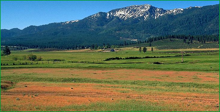
Diamond Mountain - Crystal Peak-Subsection M261Ea, eastern side of unit south of Susanville Ś Robert Ettner |
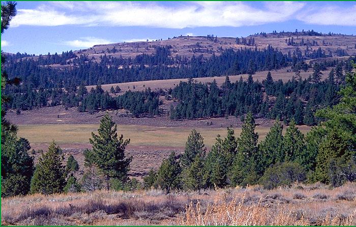
Frenchman-Subsection M261Ec, Stoney Ridge area Ś Robert Ettner |
http://www.fs.fed.us/r5/projects/ecoregions/m261ea.htm
Subsection M261Ea
Diamond Mountain - Crystal Peak
This subsection is the steeper parts of the Diamond Mountains and a high plateau adjacent to the Diamond Mountains. The climate is temperate to cold and subhumid. MLRA 22e.
Lithology and Stratigraphy. Mesozoic granitic rocks, mostly hornblende - biotite granodiorite, predominate in this subsection. There are lesser amounts of Eocene nonmarine sedimentary rocks and post-Eocene andesite, basalt, rhyolite, and pyroclastic rocks. Some sedimentary deposits are intercalated with the late Tertiary volcanic rocks.
Geomorphology. This section includes a steep fault-line scarp, or Honey Lake fault escarpment, and a rolling plateau. The escarpment is the northeast margin of the Sierra Nevada. It is aligned toward the northwest, curving around toward the west-northwest at the northern end. The high plateau is a gently sloping to moderately steep fluvial erosion surface, some of which has been modified slightly by glaciation. It is capped by remnants of volcanic rock along the ridge above the Honey Lake fault escarpment, on Red Rock, Wildcat Ridge, and a few other high ridges. Indian Creek has cut a deep canyon across the plateau. The elevation ranges from about 4000 feet along Indian Creek and 4200 at the bottom of the Honey Lake fault escarpment, to 7738 feet on Diamond Mountain, 7795 feet on Thompson Peak, and 8197 feet on Adams Peak. Faulting, mass wasting, and fluvial erosion are the main geomorphic processes.
Soils. The soils are mostly shallow Typic and Dystric Xeropsamments; Typic and Entic Xerumbrepts; and, at lower elevations, Ultic Haploxeralfs. Those on volcanic rocks are mostly Lithic and Andic Xerumbrepts; Typic Argixerolls; and Andic Haploxeralfs. The soils are mostly well drained. Soil temperature regimes are mostly frigid, with some mesic. Soil moisture regimes are xeric.
Vegetation. The predominant natural plant communities are Jeffrey pine series and White fir series, and at lower elevations Mixed conifer series. Small areas of Red fir series are present higher elevations. Big sagebrush series and Low sagebrush series are common on very stony and shallow soils in volcanic terrain. The most common streamside riparian communities are Black cottonwood series at lower elevations and Mountain alder series at higher elevations. Lodgepole pine series and Aspen series are common, but not extensive. Sedge meadow communities occur in wet areas.
Characteristic series by lifeform include:
Grasslands: Ashy ryegrass series, Green fescue series, Idaho fescue series, Montane meadow habitat, Nebraska sedge series, Needle-and-thread series, Rocky Mountain sedge series.
Shrublands: Big sagebrush series, Bitterbush series, Greenleaf manzanita series, Low sagebrush series, Parry rabbitbrush series, Rubber rabbitbrush series, Tobacco brush series.
Forests and woodlands: Aspen series, Baker cypress stands, Jeffrey pine series, Jeffrey pine - ponderosa pine series, Lodgepole pine series, Ponderosa pine series, Red fir series, Western white pine series, White fir series.
Climate. The mean annual precipitation is about 20 to 30 inches; much of it falls as snow. Mean annual temperature is about 35░ to 50░ F. The mean freeze-free period is about 25 to 100 days.
Surface Water. Runoff is rapid from most of the area. There are a few small lakes, or ponds, in glaciated terrain. Streams on the Honey Lake escarpment drain to Honey Lake. Those on the plateau west of the escarpment drain through Indian Creek to the Feather River.
Subsection M261Eb
Fredonyer Butte - Grizzly Peak
This subsection extends from the northern edge of the Sierra Nevada, which is along the Susan River, south to Grizzly Peak. It has a temperate to cold, subhumid to humid climate. MLRA 22e.
Lithology and Stratigraphy. Strongly folded basement rocks predominate in this subsection. They include metamorphosed Jurassic marine sedimentary, Jurassic-Triassic volcanic, and Paleozoic marine sedimentary and volcanic rocks. There are a few small Mesozoic granitic bodies. Tertiary volcanic rocks, largely dacitic lahar, and nonmarine sedimentary rocks are moderately extensive in the northern part of the subsection. Quaternary alluvium has accumulated in Mountain Meadows and a few smaller valleys.
Geomorphology. Steep mountain and moderately steep hill slopes predominate in this subsection. Alluvial fans, floodplains, terraces, and basin floors are present but not extensive. Keddie Ridge, one of the few mountains that is distinctly elongated, is aligned toward the west-northwest. The elevation ranges from about 4000 feet along Lights Creek up to 7387 feet on Hamilton Mountain, 7472 on Dyer Mountain on Keddie Ridge, and 8197 feet on Grizzly Peak. Faulting, mass wasting, and fluvial erosion are the main geomorphic processes. The north sides of Grizzly Peak and Keddie Ridge were glaciated during the Pleistocene.
Soils. The soils are mostly Ultic Argixerolls, Ultic Haploxeralfs, Ultic Palexeralfs, Andic Xerumbrepts; Pachic Haploxerolls; and a diverse group of shallow soils. There are Aquolls in Mountain Meadows. The soils are mostly well drained, some soils in meadows are poorly drained. Soil temperature regimes are mesic and frigid. Soil moisture regimes are mostly xeric, but aquic in Mountain Meadows.
Vegetation. The predominant natural plant communities are Jeffrey pine series, Mixed conifer series, and White fir series. Small areas of Red fir series occur at the highest elevations. Western juniper series is present on some shallow soils. The most common streamside riparian communities are Black cottonwood at lower elevations and Mountain alder series at higher elevations. Sedge meadow communities occur in wet areas.
Characteristic series by lifeform include:
Grasslands: Ashy ryegrass series, Green fescue series, Idaho fescue series, Montane meadow habitat, Nebraska sedge series, Needle-and-thread series, Rocky Mountain sedge series.
Shrublands: Bitterbush series, Greenleaf manzanita series, Parry rabbitbrush series, Rubber rabbitbrush series, Tobacco brush series.
Forests and Woodlands: Aspen series, Incense-cedar series, Jeffrey pine series, Jeffrey pine - Ponderosa pine series, Mixed conifer series, Mountain juniper series, Ponderosa pine series, Red fir series, Western white pine series, White fir series.
Climate. The mean annual precipitation is about 20 to 40 inches; much of it falls as snow. Mean annual temperature is about 40░ to 50░ F. The mean freeze-free period is about 50 to 125 days.
Surface Water. Runoff is rapid from most of the area, but slow on the basin floor in Mountain Meadows. Most of the runoff flows to tributaries of the Feather River. In the northern part of the subsection it flows to the Susan River, which runs to Honey Lake. There is a reservoir on Mountain Meadows.
Subsection M261Ec
Frenchman
This subsection is in mostly Tertiary volcanic terrain north of Sierra Valley. It has a temperate to cold, semi-arid to subhumid climate. MLRAs 21e and 22e.
Lithology and Stratigraphy. Miocene andesite and pyroclastic rocks predominate in this subsection. There are lesser amounts of Pliocene basalt and pyroclastic rocks, some exposures of Mesozoic granitic rocks, and, on the western edge of the subsection, early Tertiary and Paleozoic sedimentary rocks. Quaternary alluvial and lacustrine deposits have accumulated in valleys.
Geomorphology. Steep mountain and moderately steep hill slopes predominate in this subsection. Alluvial fans, floodplains, terraces, and basin floors are present but much less extensive. Most of the faults, and mountains that are elongated, are aligned toward the northwest. The elevation ranges from about 5000 feet adjacent to Sierra Valley up to 8323 feet on Dixie Mountain and 8372 feet on Mt. Ingalls. Faulting, mass wasting, and fluvial erosion are the main geomorphic processes.
Soils. The soils are mostly Ultic Argixerolls, Ultic Haploxeralfs, Andic Xerumbrepts, and a diverse group of shallow soils, plus Dystric Xeropsamments, Entic Haploxerolls, and Entic and Dystric Xerochrepts on granitic rocks. There are Cumulic Endoaquolls, Aridic Haploxerolls, and Aridic and Pachic Argixerolls on alluvial and lacustrine deposits. The soils are mostly well drained and some are poorly drained. Soil temperature regimes are mostly frigid, with some mesic in valleys. Soil moisture regimes are mostly xeric, but some are aridic and some in valleys are aquic.
Vegetation. The predominant natural plant communities are Jeffrey pine series, Mixed conifer series, and White fir series. There are small areas of Red fir series at the highest elevations, plus Mountain hemlock series on Mt. Ingalls. Western juniper series occurs on some shallow soils. Big sagebrush is common in valleys. The most common streamside riparian communities are Black cottonwood at lower elevations and Mountain alder series at higher elevations. Aspen series occurs in some moist habitats. Sedge meadow communities occur in wet areas.
Characteristic series by lifeform include:
Grasslands: Alpine habitat, Ashy ryegrass series, Breaked sedge series, Green fescue series, Idaho fescue series, Montane meadow habitat, Nebraska sedge series, Needle-and-thread series, Rocky Mountain sedge series.
Shrublands: Big sagebrush series, Bitterbush series, Bush chinquapin series, Deerbrush series, Greenleaf manzanita series, Huckleberry oak series, , Mountain whitethorn series, Tobacco brush series, Wedgeleaf ceanothus series.
Forests and woodlands: Aspen series, Incense-cedar series, Jeffrey pine series, Jeffrey pine - Ponderosa pine series, Mixed conifer series, Mountain hemlock series, Mountain juniper series, Ponderosa pine series, Red fir series, Western white pine series, White fir series, Whitebark pine series.
Climate. The mean annual precipitation is about 15 to 30 inches; much of it falls as snow. Mean annual temperature is about 40░ to 50░ F. The mean freeze-free period is about 50 to 100 days.
Surface Water. Runoff is rapid from most of the area, but slow on the basin floors. The runoff flows to tributaries of the Feather River. There are large reservoirs, Lake Davis and Frenchman Lake, in two valleys.