 | Batholith and Volcanic Flows-Markleeville-Glaciated Batholith |
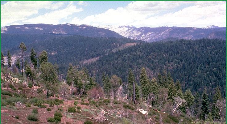
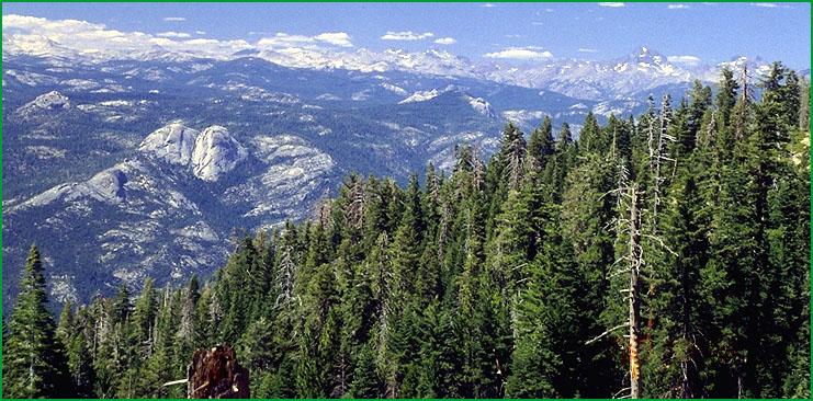
Batholith and Volcanic Flows-Subsection M261Em, Cherry Creek area looking east toward Yosemite National Park Ś David Schultz |
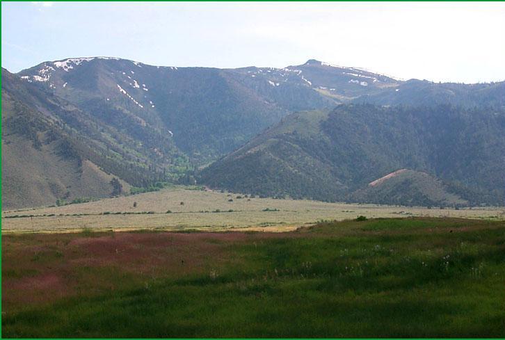
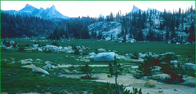
Markleeville-Subsection M261En, area west of Coleville Ś Scott Miles |
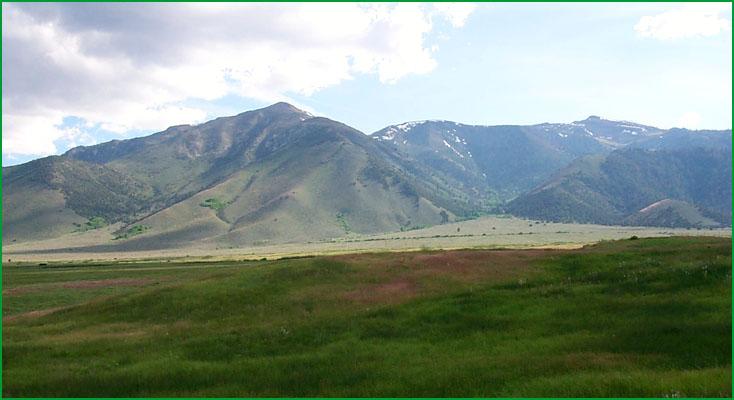
Subsection M261En, area west of Coleville Ś Scott Miles |
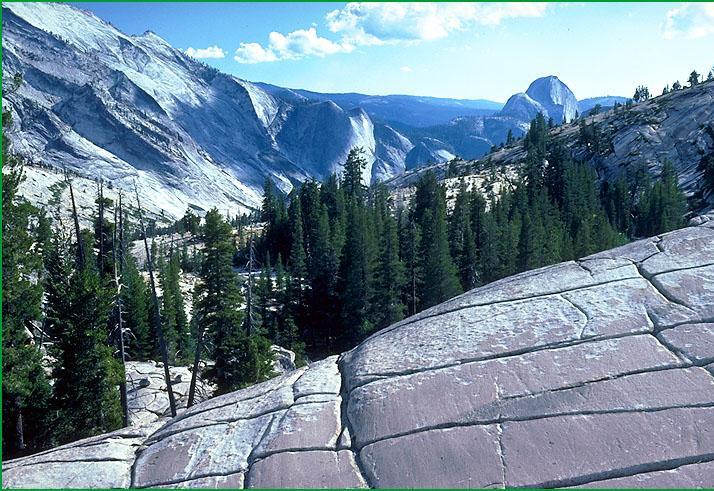
Glaciated Batholith-Subsection M261Eo, Yosemite area Ś James R. Nelson |
Subsection M261Eo, Retter Range, Fuller Buttes Ś USDA |
Subsection M261Eo Ś Chuck Goudey |
http://www.fs.fed.us/r5/projects/ecoregions/m261em.htm
Subsection M261Em
Batholith and Volcanic Flows
This subsection comprises the mid-elevations of the western slope of the Sierra Nevada between the American River and Merced River. It has a temperate and humid climate. MLRA 22d.
Lithology and Stratigraphy. Mesozoic granitic, mainly adamellite and granodiorite, and post-batholith volcanic rocks predominate in this subsection, but there are some pre-batholith rocks, too. The volcanic rocks are mostly Miocene and Pliocene andesitic lahars of the Mehrten Formation that include interbedded gravels and sands south of the Mokelumne River. The pre-batholith rocks are mostly metamorphosed Paleozoic marine sedimentary rocks.
Geomorphology. This subsection is on a gently sloping to moderately steep plateau with some steep hills on it. Several large rivers from the American to the Merced Rivers cross the subsection. These rivers and some of their tributaries flow in the bottoms of very steep sided canyons that are up to 2000 feet deep. The elevation ranges from about 3000 to 6000 feet. Mass wasting and fluvial erosion are the main geomorphic processes.
Soils. The soils are mostly Dystric and shallow Dystric Xerochrepts; Ultic Haploxeralfs; and Entic and Pachic Xerumbrepts on granitic rocks. They are mostly Andic and Entic Xerumbrepts; Ultic Haploxeralfs; and Xeric Haplohumults on volcanic rocks. The soils are mostly well drained. Soil temperature regimes are mostly mesic. Soil moisture regimes are xeric.
Vegetation. The predominant natural plant communities, from lower to higher elevations, are Ponderosa pine series, Mixed conifer series, and White fir series. There is Jeffrey pine series in volcanic terrain at higher elevations. Canyon live oak series is common on very steep rocky slopes.
Characteristic series by lifeform include:
Grasslands: Ashy ryegrass series, California oatgrass series, Montane meadow habitat, Needle-and-thread series.
Shrublands: Brewer oak series, Deerbrush series, Greenleaf manzanita series, Interior live oak series, Tobacco brush series, Wedgeleaf ceanothus series.
Forests and woodlands: Canyon live oak series, Douglas-fir series, Douglas-fir - Ponderosa pine series, Incense-cedar series, Jeffrey pine series, Knobcone pine series, Mixed conifer series, Ponderosa pine series, White fir series.
Climate. The mean annual precipitation is about 40 to 60 inches; much of it falls as snow. Mean annual temperature is about 45░ to 55░ F. The mean freeze-free period is in the range from 100 to 150 days.
Surface Water. Runoff is rapid; it flows to the American, Cosumnes, Mokelumne, Stanislaus, Tuolumne, or Merced Rivers or tributaries of them. Maximum flow in these rivers is during spring when snow is melting rapidly. There are no natural lakes, but there are some reservoirs in the subsection
Subsection M261En
Markleeville
This subsection comprises the mountainous terrain just east of the crest of the Sierra Nevada, from the south end of the Carson Range southeastward to the West Walker River near Antelope Peak. It has a cold and subhumid climate. MLRA 22e.
Lithology and Stratigraphy. Mesozoic granitic and post-batholith volcanic rocks predominate in this subsection; pre-batholith rocks are sparse. The volcanic rocks are mostly Pliocene andesite and lahars. The pre-batholith rocks are mostly undifferentiated metamorphic rocks. There are small areas of Pleistocene glacial till and outwash and Quaternary alluvium.
Geomorphology. This subsection is characterized by steep to very steep mountains. Glacial erosion has modified much of the subsection. Cirques, aretes, cols, and horns are common. The rivers flow through both very steep sided V-shaped canyons and U-shaped canyons. Alluvial basin floors are more extensive in the U-shaped canyons. The elevation ranges from about 6000 to 9000 feet, but up to 10023 on Hawkins Peak and 10,241 feet on Antelope Peak. Mass wasting and fluvial erosion are the main geomorphic processes. Pleistocene glaciation greatly modified the landscape.
Soils. The soils are mostly Andic Xerumbrepts, Ultic Haploxeralfs, Lithic Ultic Argixerolls, and Andic Xerochrepts, plus shallow Typic Xeropsamments on granitic rocks. Soils at the higher elevations are mostly Lithic and Andic Cryumbrepts, plus shallow Typic Cryopsamments on granitic rocks. The soils are mostly well drained. Soil temperature regimes are mostly frigid, but some are cryic. Soil moisture regimes are mostly xeric. Soils have udic moisture regimes where snow persists through spring, melting to keep soils moist through much of the summer. Soils with aquic moisture regimes are present in glaciated terrain and small valleys, but they are not extensive.
Vegetation. The predominant natural plant communities are Jeffrey pine series, White fir series, Mixed subalpine forest series, and Red fir series. Lodgepole pine series occurs on some wet soils, and on drier soils where cold air drainage and frost limit the regeneration of other conifers. Singleleaf pinyon, Utah juniper, and Big sagebrush series prevail at lower elevations. Aspen series is common where drifted snow accumulates and provides water during summer. Sedge meadow communities are not extensive.
Characteristic series by lifeform include:
Grasslands: Ashy ryegrass series, Fen habitat, Nebraska sedge series, Montane meadow habitat, Mountain heather - bilberry series, Needle-and-thread series, Rocky Mountain sedge series, Rothrock sagebrush series, Shorthair reedgrass series, Shorthair sedge series, Subalpine meadow habitat.
Shrublands: Big sagebrush series, Bitterbush series, Greenleaf manzanita series, Low sagebrush series, Parry rabbitbrush series, Rubber rabbitbrush series, Subalpine upland shrub habitat, Subalpine wetland shrub habitat, Tobacco brush series.
Forests and woodlands: Aspen series, Jeffrey pine series, Lodgepole pine series, Mixed subalpine forest series, Red fir series, Western white pine series, White fir series, Whitebark pine series.
Climate. The mean annual precipitation is about 35 to 45 inches; most of it falls as snow. Mean annual temperature is about 35░ to 45░ F. The mean freeze-free period is in the range from 25 to 75 days.
Surface Water. Runoff is rapid from most of the area. It flows to the Carson or Walker Rivers. Maximum flow in these rivers is during spring when snow is melting rapidly. There are many small natural lakes or ponds in glaciated terrain.
Subsection M261Eo
Glaciated Batholith
This subsection is along the crest of the Sierra Nevada from Granite Dome just south of Sonora Pass southeast to Mt. Whitney. It has a cold to very cold and humid climate. MLRA 22d.
Lithology and Stratigraphy. Mesozoic granitic rocks predominate in this subsection. There are areas of pre-batholith rocks, too. The Mesozoic plutonic rocks are mostly adamellite, or quartz monzonite, and granodiorite, but they range from granite to gabbro. The pre-batholith rocks are mostly metamorphosed Jurassic and earlier marine sedimentary and volcanic rocks. There are a few small basalt flows. Pleistocene glacial till is common and there are small areas of Quaternary alluvium.
Geomorphology. This subsection is characterized by steep mountains at the northeastern edge of a plateau that is extensive west of the crest; some of the rolling plateau west of the crest is included in this subsection. The plateau surface is interrupted by the Cathedral and Ritter Ranges west and southwest of Mammoth Pass. Glacial erosion has modified most of the landforms. Cirques, aretes, cols, horns, and smooth, striated bedrock are common. The moraines have been modified by fluvial erosion. Some of the rivers flow in the bottoms of very steep sided canyons. The elevation ranges from about 6000 or 7000 feet up to 14495 feet on Mt. Whitney. Many peaks are higher than 12000 feet. Mass wasting and fluvial erosion are the main geomorphic processes.
Soils. The soils are mostly Lithic and Andic Cryumbrepts; Dystric Xeropsamments; Typic Cryorthents; and Andic Haplumbrepts, plus Aquic Cryumbrepts in wet areas. Soils on glacial moraines are mostly Pachic and Typic Xerumbrepts. Much of the granitic rock is barren, lacking soil. The soils are mostly well drained, but those in wet meadows are somewhat poorly to poorly drained. Soil temperature regimes are mostly frigid and cryic. Soil moisture regimes are mostly xeric. Soils have udic moisture regimes where snow persists through spring, melting to keep soils moist through much of the summer. Soils with aquic moisture regimes are present in glaciated terrain and small valleys, but they are not extensive.
Vegetation. Most of this subsection is sparsely vegetated. The predominant natural plant communities are Mixed subalpine forest series and Red fir series, and communities of Subalpine meadow habitat. Jeffrey pine series are common on shallow and rocky soils at lower elevations. There is some Foxtail pine series at high elevations near the southwestern end of the subsection. Lodgepole pine series prevails on many wet soils and on drier soils where cold air drainage and frost limit the regeneration of other conifers. Sedge meadow communities are common.
Characteristic series by lifeform include:
Grasslands: Alpine habitat, Ashy ryegrass series, Fen habitat, Montane meadow habitat, Mountain heather - bilberry series, Nebraska sedge series, Needle-and-thread series, Rocky Mountain sedge series, Rothrock sagebrush series, Shorthair reedgrass series, Shorthair sedge series, Subalpine meadow habitat.
Shrublands: Bush chinquapin series, Greenleaf manzanita series, Huckleberry oak series, Mountain whitethorn series, Subalpine upland shrub habitat, Subalpine wetland shrub habitat, Tobacco brush series.
Forests and woodlands: Aspen series, Foxtail pine series, Jeffrey pine series, Limber pine series, Lodgepole pine series, Mixed subalpine forest series, Mountain hemlock series, Red fir series, Western white pine series, White fir series, Whitebark pine series.
Climate. The mean annual precipitation is about 20 inches on the southeast to 60 inches on the northwest. Most of the precipitation is snow. Mean annual temperature is about 25░ to 45░ F. The mean freeze-free period is ranges from less than 10 to about 50 days.
Surface Water. Runoff is rapid from most of the area. Most of the runoff flows to the Stanislaus Rivers, Tuolumne, Merced, San Joaquin, Kings, or Kaweah on the west; to the Walker River, Mono Lake, or Owens Valley on the east; or to the Kern River on the south. Maximum flow in these rivers is during spring when snow is melting rapidly. There are many small natural lakes or ponds in glaciated terrain.