 | Lower Batholith-Upper Batholith-Eastern Slopes |
Lower Batholith-Subsection M261Ep, Shell Mountain area Ś Robert Ettner |
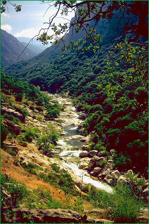
Subsection M261Ep, Tule River on the Sequoia National Forest Ś USDA |
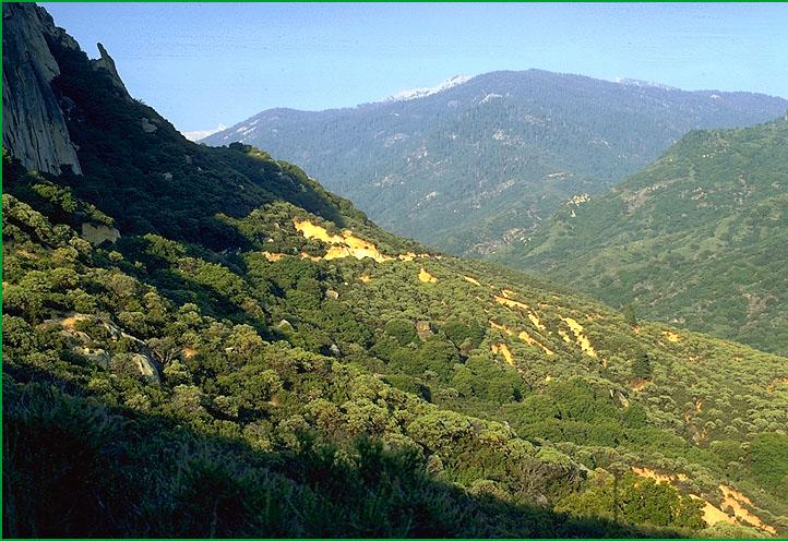
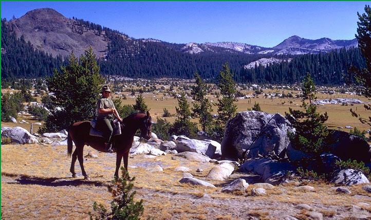
Subsection M261Ep, Indian Basin looking north to Kings River Ś Robert Ettner |
Subsection M261Ep, meadow below and west of Grand Bluffs, Sierra National Forest Ś USDA |
Upper Batholith-Subsection M261Eq, Black Peak area Ś Robert Ettner |
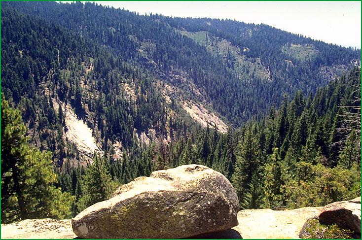
Subsection M261Eq, Kern River downstream, Deer Creek gorge Ś USDA |
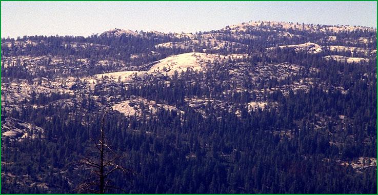
Subsection M261Eq, Bald Mountain Ś USDA |
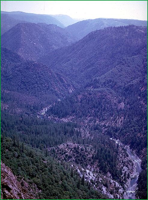
Subsection M261Eq, North Fork American River canyon, Colfax area Ś Charles B. Goudey |
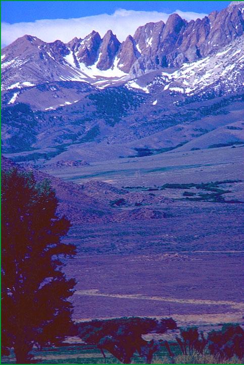
Eastern Slopes-Subsection M261Er, Lone Pine area Ś Robert Ettner |
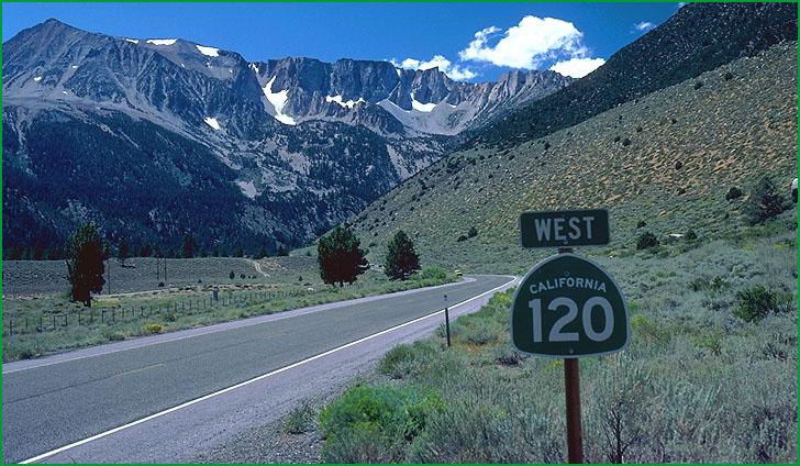
Subsection M261Er, Yosemite road to Tioga Pass Ś James R. Nelson |
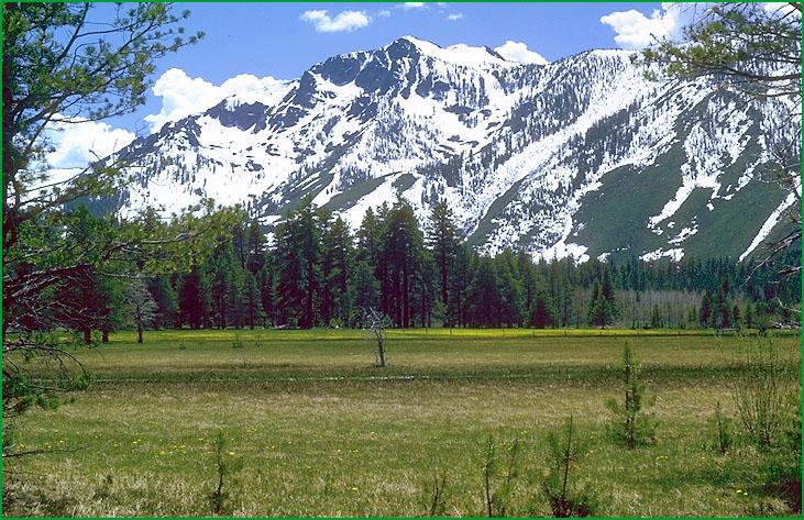
Subsection M261Er Ś Scott Miles |
Subsection M261Er, from Bishop area Ś Scott Miles |
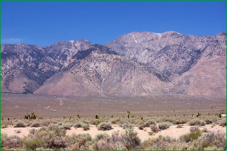
Subsection M261Er, looking west from the town of Mojave Ś Scott Miles |
Subsection M261Er, from the Indian Wells area Ś Scott Miles |


http://www.fs.fed.us/r5/projects/ecoregions/m261ep.htm
Subsection M261Ep
Lower Batholith
This subsection comprises the mid-elevations of the western slope of the Sierra Nevada from El Portal on the Merced River southwest to the Greenhorn Mountains. It has a temperate and humid climate. MLRAs 22d and 22e.
Lithology and Stratigraphy. Mesozoic granitic, mainly adamellite and granodiorite, and pre-batholith rocks predominate in this subsection. The pre-batholith rocks are metamorphosed Jurassic rocks and older metavolcanic and metasedimentary rocks.
Geomorphology. This subsection is mostly on steep slopes along the lower, or southwest, edge of the extensive Sierra Nevada plateau, and on steep mountains in the Greenhorn Mountain range. Several large rivers from the Merced to the Kings Rivers cross the subsection. These rivers and some of their tributaries flow in the bottoms of very steep sided canyons. The canyon of the Kings River is about 4000 feet deep where it enters this subsection. The elevation ranges from about 3000 feet, or less along the Kings River, to about 6500 feet. Mass wasting and fluvial erosion are the main geomorphic processes.
Soils. The soils are mostly Dystric and shallow Dystric Xerochrepts; Ultic Haploxeralfs; and Entic Ultic, Pachic, Pachic Ultic, and shallow Entic Haploxerolls on granitic rocks. Also, Dystric Lithic Xerochrepts; Haploxerolls; and Typic Haploxerults are common on metamorphic rocks. The soils are mostly well drained. Soil temperature regimes are mostly mesic. Soil moisture regimes are xeric.
Vegetation. The predominant natural plant communities are Ponderosa pine series at lower elevations and Mixed conifer series at higher elevations. In deep canyons, Canyon live oak series is common on very steep rocky slopes and Manzanita chaparral and Mixed chaparral shrublands are common on shallow soils. Most of the groves containing the Giant sequoia series occur in this subsection.
Characteristic series by lifeform include:
Grasslands: Ashy ryegrass series, California oatgrass series, Montane meadow habitat, Needle-and-thread series.
Shrublands: Brewer oak series, Chamise series, Deerbrush series, Greenleaf manzanita series, Interior live oak series, Tobacco brush series, Wedgeleaf ceanothus series.
Forests and woodlands: Birchleaf mountain-mahogany series, Black oak series, Canyon live oak series, Incense-cedar series, Mixed conifer series, Ponderosa pine series, Giant sequoia series, White fir series.
Climate. The mean annual precipitation is about 30 to 60 inches; much of it falls as snow. Mean annual temperature is about 45░ to 55░ F. The mean freeze-free period is in the range from 100 to 150 days.
Surface Water. Runoff is rapid; it flows to the Merced, San Joaquin, Kings, Kaweah, Tule, or Kern Rivers or tributaries of them. Maximum flow in these rivers is during spring when snow is melting rapidly. There are no natural lakes, but there are some reservoirs.
Subsection M261Eq
Upper Batholith
This subsection comprises the higher elevations of the western slope of the Sierra Nevada from the Grand Canyon of the Tuolumne River south-southwest to Slate Mountain, which is on the drainage divide west of the Kern River. It has a cold and humid climate. MLRA 22e.
Lithology and Stratigraphy. Mesozoic granitic rocks predominate in this subsection; pre-batholith metamorphic rocks are common, but post-batholith volcanic rocks are sparse. Pleistocene glacial till and outwash are common in the northern part to sparse in the southern part of the subsection. There are small areas of Quaternary alluvial and lacustrine deposits.
Geomorphology. This subsection is on a gently sloping to moderately steep plateau with some steep mountains on it. Glacial erosion has modified most of the valleys. Several large rivers between the Tuolumne and Tule Rivers head in or cross the subsection. Some of these rivers flow in the bottoms of very steep sided canyons. The elevation ranges about 6000 to 10000 feet. Mass wasting and fluvial erosion are the main geomorphic processes.
Soils. The soils are mostly Dystric Xeropsamments; Dystric Xerorthents; Dystric Xerochrepts; and Entic, Typic, and Pachic Xerumbrepts, plus Aquic Cryumbrepts in wet areas. There are some Cryumbrepts at the highest elevations. The soils are mostly well drained. Soil temperature regimes are mostly frigid, but some are cryic. Soil moisture regimes are mostly xeric. Soils have udic moisture regimes where snow persists through spring, melting to keep soils moist through much of the summer. Soils with aquic moisture regimes are present in glaciated terrain and small valleys, but they are not extensive.
Vegetation. The predominant natural plant communities, from lower to higher elevations, are Mixed conifer series, White fir series, and Red fir series. Jeffrey pine series is common on shallow and rocky soils. Lodgepole pine series prevails on many wet soils and on drier soils where cold air drainage and frost limit the regeneration of other conifers. Sedge meadow communities are common, but they are not extensive. Some groves of Giant sequoia series occur at lower elevations in this subsection.
Characteristic series by lifeform include:
Grasslands: Ashy ryegrass series, California oatgrass series, Montane meadow habitat, Needle-and-thread series.
Shrublands: Brewer oak series, Chamise series, Deerbrush series, Greenleaf manzanita series, Interior live oak series, Tobacco brush series, Wedgeleaf ceanothus series.
Forests and woodlands: Giant sequoia series, Incense-cedar series, Jeffrey pine series, Lodgepole pine series, Mixed conifer series, Red fir series, White fir series.
Climate. The mean annual precipitation is about 40 to 60 inches; most of it falls as snow. Mean annual temperature is about 35░ to 50░ F. The mean freeze-free period is about 25 to 100 days.
Surface Water. Runoff is rapid from most of the area. Most of the runoff flows to the Tuolumne, Merced, San Joaquin, Kings, Kaweah, Tule, or Kern Rivers or tributaries of them. Maximum flow in these rivers is during spring when snow is melting rapidly. There are many small natural lakes or ponds in glaciated terrain, and some reservoirs.
Subsection M261Er
Eastern Slopes
This subsection comprises the very steep eastern slope of the Sierra Nevada from Eagle Peak west of Bridgeport south to the Tehachapi Pass area. It includes South Fork Valley of the Kern River system, most of the Scodie (or Kiavah) Mountains, and Kelso Valley. It has a hot to very cold and arid to humid climate. MLRAs 22e and 29f.
Lithology and Stratigraphy. Mesozoic granitic predominate in this subsection, but there are large areas of pre-batholith sedimentary and metamorphic rocks. Volcanic rocks are sparse; the largest exposure being Pleistocene basalt and pyroclastic rocks at Crater Mountain on the west side of Owens Valley, near Poverty Hill. Pleistocene glacial till and outwash are common in the northern part of the subsection. Quaternary alluvium is extensive only in Kelso and South Fork Valleys near the southern end of the Sierra Nevada.
Geomorphology. This subsection is characterized by very steep fault-line scarp and steep mountains. Slopes are gently sloping to moderately steep on Quaternary volcanic rocks, which are not extensive, and very gently to moderately sloping on Quaternary alluvial fans and basin floors. Glacial erosion has modified much of the northern part of the subsection. Cirques, aretes, cols, and horns are common there. The rivers, except some of those in glaciated terrain, flow through very steep sided V-shaped canyons. The elevation ranges about 2500 to 10,000 feet. Faulting, mass wasting and fluvial erosion are the main geomorphic processes.
Soils. The soils are Lithic Torriorthents; Typic and shallow Xeric Torripsamments; shallow Typic Xeropsamments; Aridic, Torriorthentic, and shallow Entic Haploxerolls; shallow Typic Cryopsamments; Andic and Lithic Cryumbrepts; Typic Argixerolls; and Ultic Haploxeralfs. Vitrandic Torriorthents are common on Crater Mountain. Soils in Kelso and South Fork Valleys are mostly Xeric Torripsamments and Xerollic Haplargids. The soils are mostly well drained. Soil temperature regimes are thermic, mesic, frigid, and cryic. Soil moisture regimes are mostly xeric on the north to aridic on the south end of the subsection. Soils may have udic moisture regimes where snow persists through spring, melting to keep soils moist through much of the summer.
Vegetation. The predominant natural plant communities northwest of Round Mountain are Jeffrey pine series, White fir series, Mixed subalpine forest series, and Red fir series, with Big sagebrush series at lower and communities of Subalpine meadow habitat at higher elevations. South of about Wonoga Peak, near Owens Lake, they are mainly Singleleaf pinyon series and lesser amounts of Black bush series. Also, there are Joshua tree series, California buckwheat series, and Mixed scrub shrublands at the south end of the Sierra Nevada, and Needlegrass grasslands in South Fork Valley.
Characteristic series by lifeform include:
Grasslands: Ashy ryegrass series, Montane meadow habitat, Mountain heather - bilberry series, Nebraska sedge series, Needle-and-thread series, Rocky Mountain sedge series, Rothrock sagebrush series, Shorthair reedgrass series, Shorthair sedge series, Subalpine meadow habitat.
Shrublands: Big sagebrush series, Bitterbush series, Black bush series, California buckwheat series, Greenleaf manzanita series, Joshua tree series, Low sagebrush series, Parry rabbitbrush series, Rubber rabbitbrush series, Subalpine upland shrub habitat, Subalpine wetland shrub habitat, Tobacco brush series.
Forests and woodlands: Aspen series, Jeffrey pine series, Lodgepole pine series, Mixed subalpine forest series, Piute cypress stands, Red fir series, Singleleaf pinyon series, White fir series.
Climate. The mean annual precipitation is about 8 to 50 inches. Most of the precipitation is snow at higher elevations. Mean annual temperature is about 35░ to 60░ F. The mean freeze-free period is about 25 to 200 days.
Surface Water. Runoff is rapid from most of the area. It flows to closed basins in the Basin and Ranges, or, from the south end of the subsection, to the Kern River. There are many small natural lakes or ponds in glaciated terrain.