 | Mowitz Buttes-Goose Lake Basin- Warner Mountains-Pit River Valley |
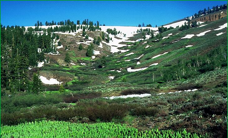
Warner Mountains-Subsection M261Gf, west of Warner Peak Ś James R. Nelson |
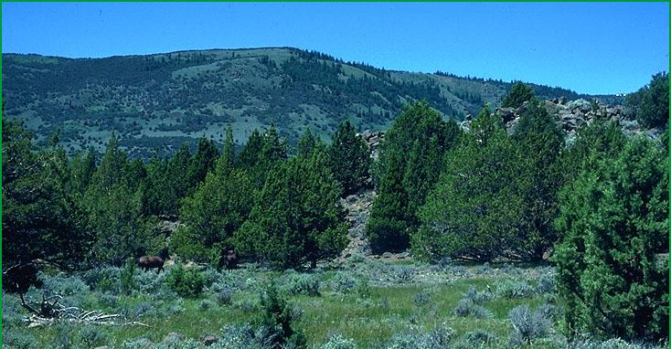
Subsection M261Gf, Warner Mountains in background, Juniper woodland in foreground Ś James R. Nelson |
http://www.fs.fed.us/r5/projects/ecoregions/m261gd.htm
Subsection M261Gd
Mowitz Buttes
This subsection is a volcanic plateau, between the Big Valley Mountains (subsection M261Gn) and DevilÆs Garden (subsection M261Gb). The climate is temperate and subhumid. MLRA
Lithology and Stratigraphy. The bedrock is predominantly Pleistocene, and possibly some late Tertiary, basalt and lesser amounts of pyroclastic rocks. There are some alluvial and lacustrine deposits in small depressions and around Egg Lake.
Geomorphology. The main landform is a gently to moderately sloping plateau with few moderately steep hills that might be eroded shield domes. The plateau has a moderately well integrated drainage system, with few small closed depressions. Basin-fill on basin floors in the small depressions is a small but important part of the subsection. The elevation range is from about 4300 feet in low basins up to 5415 feet on a butte. Fluvial erosion and deposition, lacustrine deposition, and freeze-thaw are the main geomorphic processes.
Soils. Soils on uplands are mostly Typic, Lithic, and Pachic Ultic Argixerolls and lesser amounts of Alfic Vitrixerands, Andic Haploxeralfs, Vitrandic Palexeralfs, shallow Argiduridic Durixerolls, and shallow Typic Durixeralfs. Soils in alluvial and lacustrine deposits on basin floors are most commonly Aquic Haploxerolls, Chromic Haploxererts and Xeric Endoaquerts. The soils are well drained on upland and well to poorly drained on basin floors. Soil temperature regimes are mostly mesic. Soil moisture regimes are mostly xeric, but some are aquic on basin floors.
Vegetation. Natural plant communities are predominantly Ponderosa pine series and some Western juniper series and Big sagebrush series. Low sagebrush series is common on shallow soils. Sedge meadow communities occur in basins.
Characteristic series by lifeform include:
Grasslands: Ashy ryegrass series, Bluebunch wheatgrass series, California oatgrass series, Creeping ryegrass series, Idaho fescue series, Indian ricegrass series, Nebraska sedge series, Needle-and-thread series.
Shrublands: Big sagebrush series, Curlleaf mountain-mahogany series, Bitterbrush series, Parry rabbitbrush series, Rubber rabbitbrush series.
Forests and woodlands: Aspen series, Knobcone pine series, Oregon white oak series, Ponderosa pine series, Western juniper series, White fir series.
Climate. The mean annual precipitation is about 15 to 25 inches. Much of the precipitation is snow. Mean annual temperature is about 45░ to 50░ F. The mean freeze-free period is in the range from 75 to 100 days.
Surface Water. Runoff from uplands is rapid; much of it drains down through joints in the basalt to the ground water reservoir, limiting overland flow of water and development of stream channels. Some of the drainage is internal, to closed depressions in and around the subsection, and water ponds in many small depressions. There are few stream and most of those are dry during summer. Streams that flow from the subsection drain to the Pit River or its tributaries
Subsection M261Ge
Goose Lake Basin
This subsection consists of an alluvial-lacustrine plain around Goose Lake. The climate is temperate and semi-arid to subhumid. MLRA 21e.
Lithology and Stratigraphy. Quaternary alluvial and lacustrine deposits dominate this subsection. There are a few small areas of Pleistocene basalt.
Geomorphology. The landforms are gently sloping to nearly level alluvial fans and basin floor, or lake plain. The elevation range is about 4700 to 5000 feet. Fluvial and lacustrine erosion and deposition and freeze-thaw are the main geomorphic processes.
Soils. Soils on basin floor or lake plain are mostly Cumulic Haploxerolls, Typic and Aquandic Argialbolls, Typic Natrixeralfs, and Xeric Endoaquerts. Those on alluvial fans are mostly Xerollic and shallow Xerollic Durargids and Argiduridic and Palexerollic Durixerolls. Those on basalt are mostly Lithic Argixerolls and Abruptic Xerollic Durargids. The soils are well to poorly drained. Soil temperature regimes are mesic. Soil moisture regimes are aridic, xeric, and aquic.
Vegetation. The natural plant communities include Big sagebrush series, Low sagebrush series, Mixed saltbush series, and Sedge meadow communities.
Characteristic series by lifeform include:
Marshes: Bulrush series, Bulrush - cattail series, Cattail series.
Grasslands: Alkali sacaton series, Ashy ryegrass series, Common reedgrass series, Creeping ryegrass series, Idaho fescue series, Indian ricegrass series, Needle-and-thread series, Pickleweed series, Saltgrass series.
Shrublands: Big sagebrush series, Bitterbush series, Greasewood series, Iodine bush series, Mixed saltbush series, Parry rabbitbrush series, Rubber rabbitbrush series, Shadscale series.
Climate. The mean annual precipitation is about 15 to 20 inches. Much of the precipitation is snow. Mean annual temperature is about 46░ to 48░ F. The mean freeze-free period is in the range from 100 to 125 days.
Surface Water. Runoff is very slow. It drains to Goose Lake, which has no outlet now but drained to the Pit River when the lake level was higher.
Subsection M261Gf
Warner Mountains
This subsection comprises the Warner Mountains. The climate is cold to very cold and subhumid. MLRAs 21e and 22e.
Lithology and Stratigraphy. The bedrock is predominantly Miocene basalt and Tertiary pyroclastic rocks. Shallow (hypabyssal) Tertiary intrusive rocks are common in the northern part of the Warner Mountains. The Warner Mountains are tilted westward, a process that is continuing by uplift on the Surprise Valley Fault, relative to Surprise Valley, which is along the eastern edge of the subsection. There are many small valleys, but only Fandango Valley has more than a few hundred acres of alluvial fill. There are a few small areas of glacial till.
Geomorphology. The Warner Mountains are a north-south aligned mountain block that is very steep on the east side and moderately steep to steep on the west side. They have been modified by glacial and fluvial erosion. The elevation range is from about 5000 feet up to 9892 feet on Eagle Peak. Fluvial erosion and freeze-thaw are the main geomorphic processes, plus mass wasting on the east side of the mountains.
Soils. Soils are mostly Typic, Lithic, Pachic, and Argic Cryoborolls; Dystric Xerorthents; Andic Xerumbrepts; Typic, Lithic Ultic, Pachic, and Pachic Ultic Argixerolls. The soils are well drained. Soil temperature regimes are frigid and cryic. Soil moisture regimes are xeric.
Vegetation. The predominant natural plant communities are Ponderosa pine series, Jeffrey pine series, Mixed conifer series, and White fir series. Lodgepole pine series, Aspen series, and Sedge meadow communities are common, and Whitebark pine series occurs at higher elevations. Montane meadow, Montane wetland shrub, Subalpine meadow, and Subalpine wetland shrub habitats are present.
Characteristic series by lifeform include:
Grasslands: Ashy ryegrass series, Bluebunch wheatgrass series, California oatgrass series, Creeping ryegrass series, Idaho fescue series, Indian ricegrass series, Nebraska sedge series, Needle-and-thread series, Rocky Mountain sedge series, Shorthair sedge series, Tufted hairgrass series.
Shrublands: Big sagebrush series, Bitterbrush series, Black sagebrush series, Low sagebrush series, Parry rabbitbrush series, Rubber rabbitbrush series, Tobacco brush series.
Forests and woodlands: Aspen series, Curlleaf mountain-mahogany series, Ponderosa pine series, Lodgepole pine series, Washoe pine series, White fir series, Whitebark pine series.
Climate. The mean annual precipitation is about 20 to 30 inches. Much of the precipitation is snow. Mean annual temperature is about 30░ to 45░ F. The mean freeze-free period is in the range from 25 to 100 days.
Surface Water. Runoff from uplands is rapid. Many of the streams are perennial; some are dry during at least part of summer. Streams on the west drain to Goose Lake or the Pit River, and those on the east side of the mountains, which are much shorter, drain to Surprise Valley.
Subsection M261Gg
Pit River Valley
This subsection consists of a low area along the Pit River. The climate is temperate and semi-arid to subhumid. MLRA 21e.
Lithology and Stratigraphy. Pliocene nonmarine sedimentary deposits, Pleistocene basalt, and Quaternary alluvial and lacustrine deposits are the main components in this subsection.
Geomorphology. The landforms are gently sloping to moderately steep plains and hills on slightly to moderately eroded and dissected lava flows and nonmarine sedimentary deposits, and nearly level floodplains and basin floors. There are both lacustrine and alluvial deposits on the basin floors. The elevation range is about 4300 to 5800 feet. Faulting, fluvial erosion and deposition and freeze-thaw are the main geomorphic processes.
Soils. Soils on basalt are mostly Lithic, Typic, and Pachic Argixerolls; Leptic Haploxererts; Xerertic Haplargids; and shallow Argiduridic Durixerolls. Those on Pliocene sedimentary deposits are mostly Typic, Aridic, and Pachic Argixerolls; shallow Argiduridic Durixerolls; Xerollic and Palexerollic Durargids; and Entic Chromoxererts. Soils on flood plains and basin floor are mostly Aquic Xerofluvents; Aquandic Humaquepts; Xeric Endoaquerts; Andaqueptic Haplaquolls; and Typic Argiaquolls. The soils are well to poorly drained. Soil temperature regimes are mesic. Soil moisture regimes are aridic, xeric, and aquic.
Vegetation. The predominant natural plant communities are Big sagebrush series and Sedge meadow communities.
Characteristic series by lifeform include:
Grasslands: Ashy ryegrass series, Bluebunch wheatgrass series, California oatgrass series, Creeping ryegrass series, Idaho fescue series, Indian ricegrass series, Nebraska sedge series, Needle-and-thread series.
Shrublands: Big sagebrush series, Bitterbrush series, Parry rabbitbrush series, Rubber rabbitbrush series.
Climate. The mean annual precipitation is about 8 to 20 inches. Much of the precipitation is snow. Mean annual temperature is about 46░ to 50░ F. The mean freeze-free period is in the range from 100 to 125 days.
Surface Water. Runoff is rapid from upland and slow on basin floor. The Pit River is a tributary of the Sacramento River