 | Upper San Gabriel Mountains - Santa Ana Mountains- San Gorgonio Mountains- San Gorgonio Mountains- Upper San Gorgonio Mountains |
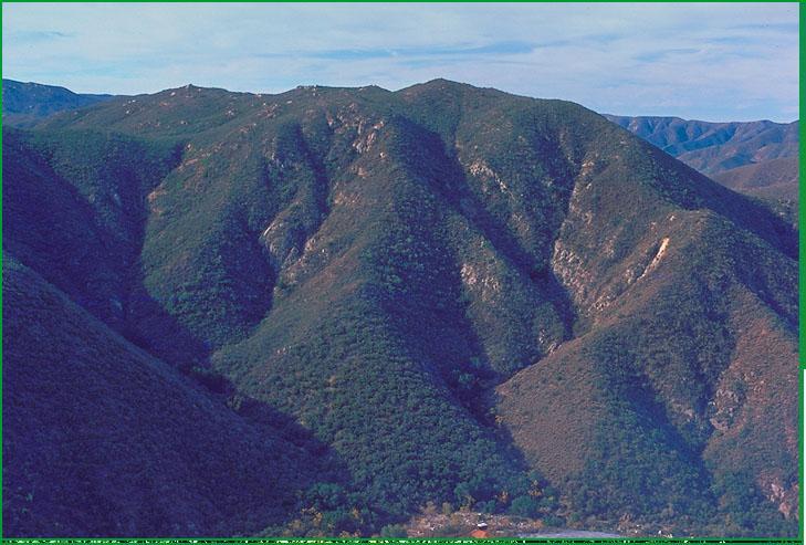
Santa Ana Mountains - San Mateao Canyon area Ś Robert Ettner |
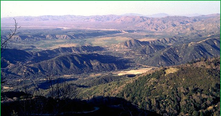
San Gorgonio Mountains-North Fork Mohave River area Ś Robert Ettner |
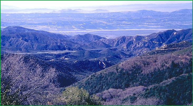
San Gorgonio Mountains- Santa Ana River area, San Bernardino National Forest Ś Robert Ettner |
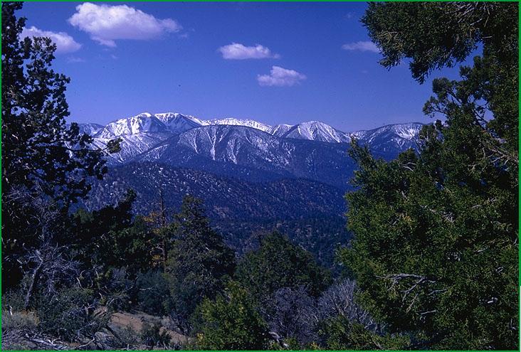
Upper San Gorgonio Mountains- Onyz Peak area Ś Robert Ettner |
http://www.fs.fed.us/r5/projects/ecoregions/m262be.htm
Subsection M262Be
Upper San Gabriel Mountains
This subsection comprises the higher and cooler parts of the San Gabriel Mountains. The climate is temperate to cold and subhumid. MLRA 20e.
Lithology and Stratigraphy. This subsection contains mostly Mesozoic granitic rocks and Pre-Cretaceous Pelona schist. Also, there are some Pre-Cambrian plutonic and metamorphic rocks and small areas of Quaternary alluvium.
Geomorphology. This is a subsection of steep and very steep mountains with narrow to rounded summits and narrow canyons. The mountains trend east-west. The subsection elevation range is from about 5000 feet, or lower on north-facing slopes, up to 10,080 feet on Mount San Antonio (Old Baldy). Mass wasting and fluvial erosion are the main geomorphic processes.
Soils. The soils are mostly Lithic Xerorthents, shallow Entic Haploxerolls, Lithic Haploxerolls, and Xerochrepts. There are some small areas of Xerofluvents and Haploxerolls on Quaternary alluvium. Most of the soils are leached free of carbonates. The soils are well drained. Soil temperature regimes are mostly mesic, and some are frigid. Soil moisture regimes are xeric.
Vegetation. The predominant natural plant communities are Coulter pine series, Mixed conifer series on the south side, and Jeffrey pine series on the north side of the mountains. Lodgepole pine series is common at the highest elevations, and Limber pine series occurs on dry slopes.
Characteristic series by lifeform include:
Grasslands: Beaked sedge series, Bur-reed series, Shorthair sedge series, Tufted hairgrass series.
Shrublands: Bush chinquapin series, Chamise series, Deerbrush series, Eastwood manzanita series, Greenleaf manzanita series, Holodiscus series, Mixed scrub oak series, Mountain whitethorn series, Parry rabbitbrush series, Rothrock sagebrush series, Rubber rabbitbrush series, Scrub oak series, Scrub oak - chaparral whitethorn series.
Forests and woodlands: Bigcone Douglas-fir series, Bigcone Douglas-fir - canyon live oak series, Birchleaf mountain-mahogany series, Black cottonwood series, Canyon live oak series, Coast live oak series, Curlleaf mountain-mahogany series, Coulter pine series, Coulter pine - canyon live oak series, Incense-cedar series, Jeffrey pine series, Limber pine series, Lodgepole pine series, Mixed conifer series, Mixed subalpine forest series, Mountain juniper series, Ponderosa pine series, White fir series.
Climate. The mean annual precipitation is about 30 to 40 inches; much of it is snow. Mean annual temperature is about 40░ to 50░ F. The mean freeze-free period is about 150 to 225 days.
Surface Water. Runoff is rapid. All but the larger streams are dry through the summer. Natural lakes are absent.
Subsection M262Bf
Santa Ana Mountains
This subsection includes the Puente and Chino Hills, which are northwest of the Santa Ana River, and most of the Santa Ana Mountains, which are southeast of the Santa Ana River. The climate is hot and subhumid; it is modified moderately by marine influence. MLRA 20d.
Lithology and Stratigraphy. This subsection contains mostly Jurassic marine clastic sedimentary, Jurassic volcanic, and Mesozoic granitic rocks. There is some mafic plutonic rock and small areas of Pleistocene basalt. The Puente and Chino Hills consist of Miocene marine sedimentary rocks.
Geomorphology. This is a subsection of steep to very steep mountains with narrow to rounded summits and narrow canyons. There are some rolling plateau surfaces, also. The hills northwest of the Santa Ana River are steep. These hills and the Santa Ana Mountains trend northwest. The Santa Ana Mountains are bounded on the northeast by a steep escarpment along the Elsinore Fault Zone, and the Puente and Chino Hills are bounded on the south-southwest by the Whittier Fault Zone. The subsection elevation range is from about 300 feet along the Santa Ana River up to 5687 feet on Santiago Peak. Mass wasting and fluvial erosion are the main geomorphic processes.
Soils. The soils are mostly shallow Typic Xerorthents, Typic Xerochrepts, and Typic Haploxeralfs on granitic rocks and Lithic Xerorthents, Lithic Haploxerolls, and Typic Haploxeralfs on Jurassic sedimentary and volcanic rocks. They are Calcic and Pachic Haploxerolls and Typic Argixerolls on Miocene sedimentary rocks. Rhodoxeralfs and Haploxeralfs predominate on mafic plutonic and volcanic rocks. Most of the soils, except those in the Puente and Chino Hills, are leached free of carbonates. The soils are well drained. Soil temperature regimes are mostly thermic, but some are mesic on north-facing slopes at higher elevations. Soil moisture regimes are xeric.
Vegetation. The predominant natural plant communities are Coast live oak series, Chamise series, which is generally on shallow or very stony soils on south-facing slopes, Manzanita chaparral shrublands, and Mixed scrub oak series. Some Bigcone Douglas-fir series occurs on north-facing slopes, Canyon live oak series occurs in canyons, California sagebrush series occurs on south-facing slopes at lower elevations, and Coulter pine series occurs at higher elevations.
Characteristic series by lifeform include:
Vernal pools: Santa Rosa Plateau vernal pools.
Grasslands: California annual grassland series, Purple Needlegrass series.
Shrublands: California buckwheat series, California sagebrush - black sage series, California sagebrush - California buckwheat series, Chamise series, Chamise - black sage series, Chamise - white sage series, Chamise - hoaryleaf ceanothus series, Eastwood manzanita series, Hairyleaf ceanothus series, Hoaryleaf ceanothus series, Mixed scrub oak series, Scrub oak series, Scrub oak - chaparral whitethorn series, Scrub oak - chamise series, Sumac series, White sage series.
Forests and woodlands: Bigcone Douglas-fir series, Bigcone Douglas-fir - canyon live oak series, Black oak series, Canyon live oak series, Coast live oak series, Coulter pine series, Coulter pine - canyon live oak, Coast live oak series, Engelmann oak series, Interior live oak series, Knobcone pine series, Tecate cypress stands.
Climate. The mean annual precipitation is about 15 to 25 inches. Most of it is rain, except at higher elevations. Mean annual temperature is about 45░ to 62░ F. The mean freeze-free period is about 200 to 300 days.
Surface Water. Runoff is rapid. All but the larger streams are dry through the summer. Natural lakes are absent, but some of the streams drain to Lake Elsinore on the northeast side of the subsection.
Subsection M262Bg
San Gorgonio Mountains
This subsection comprises the lower and warmer parts of the San Bernardino Mountains, which are between the southern branch of the San Andreas fault on the south-southwest and the Mojave Desert on the north. It extends from the Cajon Pass eastward to near the Pipes Canyon fault. It includes mountains between the Mission Creek fault and the Banning fault on the south. The climate is hot to temperate and subhumid. Marine effects on climate are moderate on the south-southwest side and slight on the north and east sides of the mountains. MLRA 20e.
Lithology and Stratigraphy. This subsection contains mostly Mesozoic granitic rocks and Pre-Cambrian igneous and metamorphic rocks. Also, there is some Paleozoic marine sedimentary rock and minor amounts of Pliocene nonmarine sediments. The mountains are a horst with faults and steep escarpments on the south-southwest, east-northeast, and west-northwest sides. Quaternary nonmarine sediments and Recent alluvium are small but important components of the subsection.
Geomorphology. This is a subsection of steep and very steep mountains with narrow to rounded summits and narrow canyons. The subsection elevation range is from about 1500 feet up to 6000 feet. Mass wasting and fluvial erosion are the main geomorphic processes.
Soils. The soils are mostly shallow Typic Xerorthents, shallow Entic Haploxerolls, Entic Ultic Haploxerolls, and Mollic Haploxeralfs on granitic and Pre-Cambrian rocks and Lithic and Typic Xerochrepts on Paleozoic marine sedimentary rocks. On Recent alluvium and Quaternary marine sediments there are Typic and Mollic Xerofluvents and Ultic Argixerolls. Most of the soils are leached free of carbonates. The soils are well drained. Soil temperature regimes are thermic at lower elevations and on south-facing slopes, and some are mesic on north-facing slopes at higher elevations. Soil moisture regimes are xeric.
Vegetation. The predominant natural plant communities are Chamise series on shallow and very stony soils, Live oak chaparral shrublands, and Mixed chaparral shrublands at lower elevations and on south-facing slopes; Ponderosa pine series and Mixed conifer series at higher elevations; and Jeffrey pine series on the north side of the mountains.
Characteristic series by lifeform include:
Grasslands: California annual grassland series, Desert needlegrass series.
Shrublands: Bigberry manzanita series, Bitterbrush series, Black bush series, California buckwheat series, California sagebrush series, Chamise series, Chamise - bigberry manzanita series, Chamise - Eastwood manzanita series, Chamise - hoaryleaf ceanothus series, Chamise - cupleaf ceanothus series, Chamise - white sage series, Chamise - black sage series, Chaparral whitethorn series, Cupleaf ceanothus - fremontia - oak series, Eastwood manzanita series, Fourwing saltbush series, Hoaryleaf ceanothus series, Scrub oak series, Scrub oak chaparral - whitethorn series, Interior live oak shrub series, Interior live oak - chaparral whitethorn series, Interior live oak - scrub oak shrub series, Interior live oak - canyon live oak shrub series, Mixed scrub oak series, Mulefat series, Scrub oak series, Scrub oak - chamise series, Scrub oak - chaparral whitethorn series, Scalebroom series.
Forests and woodlands: Birchleaf mountain-mahogany series, California juniper series, California walnut series, Coulter pine series, Coulter pine - canyon live oak series, Bigcone Douglas-fir series, Bigcone Douglas-fir - canyon live oak series, Black oak series, Canyon live oak series, Coast live oak series, Curlleaf mountain-mahogany series, Knobcone pine series, Interior live oak series, Jeffrey pine series, Mixed conifer series, Ponderosa pine series, Singleleaf pinyon series, Singleleaf pinyon - Utah Juniper series.
Climate. The mean annual precipitation is about 20 to 30 inches. Most of it is rain at lower elevations and snow at higher elevations. Mean annual temperature is about 45░ to 60░ F. The mean freeze-free period is about 200 to 250 days.
Surface Water. Runoff is rapid. All but the larger streams are dry through the summer. Natural lakes are absent.
Subsection M262Bh
Upper San Gorgonio Mountains
This subsection comprises the higher elevations and cooler parts of the San Bernardino Mountains. The climate is temperate to cold, and subhumid. MLRA 22d.
Lithology and Stratigraphy. This subsection contains mostly Mesozoic granitic rocks. Also, there are some Pre-Cambrian gneiss and Paleozoic marine sedimentary rocks. The mountains are a horst with faults and steep escarpments on the south-southwest, east-northeast, and west-northwest sides. Quaternary nonmarine sediments and Recent alluvium are small but important components of the subsection.
Geomorphology. This is a subsection of steep and very steep mountains with narrow to rounded summits. There is a high rolling plateau surface at about 6500 to 7500 feet with some Quaternary fluvial and lacustrine deposits on it. The subsection elevation range is from about 4000 feet up to 11,502 feet on Mount San Gorgonio. Mass wasting and fluvial erosion are the main geomorphic processes.
Soils. The soils are mostly shallow Typic Xeropsamments, Typic Xerochrepts, Pachic Xerumbrepts, and Ultic Argixerolls. Also, there are Mollic Xerofluvents on late Quaternary alluvium. The soils are leached free of carbonates. The soils are well drained. Soil temperature regimes are mostly mesic, and some frigid at higher elevations. Soil moisture regimes are xeric.
Vegetation. The predominant natural plant community is Ponderosa pine series. There are small areas of Coulter pine series, Mixed chaparral shrublands, Jeffrey pine series on the north side of the mountains, and small areas of Limber pine series. Lodgepole pine series is common at higher elevations.
Characteristic series by lifeform include:
Grasslands: Alpine habitat, Beaked sedge series, Bur-reed series, Creeping ryegrass series, Shorthair sedge series, Sedge series, Tufted hairgrass series.
Shrublands: Big sagebrush series, Black sagebrush series, Bush chinquapin series, Deerbrush series, Eastwood manzanita series, Greenleaf manzanita series, Interior live oak - chaparral whitethorn series, Interior live oak - canyon live oak shrub series, Interior live oak - scrub oak shrub series, Mixed saltbush series, Mixed scrub oak series, Mountain whitethorn series, Rothrock sagebrush series, Rubber rabbitbrush series, Scrub oak series, Scrub oak - chamise series.
Forests and woodlands: Aspen series, Bigcone Douglas-fir series, Bigcone Douglas-fir - canyon live oak series, Black cottonwood series, Black oak series, Canyon live oak series, Coulter pine - canyon live oak series, Curlleaf mountain-mahogany series, Incense-cedar series, Jeffrey pine series, Jeffrey pine - Ponderosa pine series, Limber pine series, Lodgepole pine series, Mixed conifer series, Mixed subalpine forest series, Mountain juniper series, Singleleaf pinyon series, White fir series.
Climate. The mean annual precipitation is about 30 to 40 inches. Much of it is snow. Mean annual temperature is about 40░ to 50░ F. The mean freeze-free period is about 150 to 200 days.
Surface Water. Runoff is rapid. All but the larger streams are dry through the summer. There have been natural lakes on the high plateau recently, but any lakes that persisted until historical time have been replaced by reservoirs.
Subsection M262Bh
Upper San Gorgonio Mountains
This subsection comprises the higher elevations and cooler parts of the San Bernardino Mountains. The climate is temperate to cold, and subhumid. MLRA 22d.
Lithology and Stratigraphy. This subsection contains mostly Mesozoic granitic rocks. Also, there are some Pre-Cambrian gneiss and Paleozoic marine sedimentary rocks. The mountains are a horst with faults and steep escarpments on the south-southwest, east-northeast, and west-northwest sides. Quaternary nonmarine sediments and Recent alluvium are small but important components of the subsection.
Geomorphology. This is a subsection of steep and very steep mountains with narrow to rounded summits. There is a high rolling plateau surface at about 6500 to 7500 feet with