 | Fremont - Livermore Hills and Valleys-Western Diablo Range-Diablo Range |
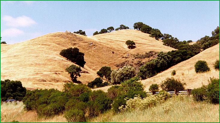
Fremont - Livermore Hills and Valleys-Sunol area Ś Patsy Miles |
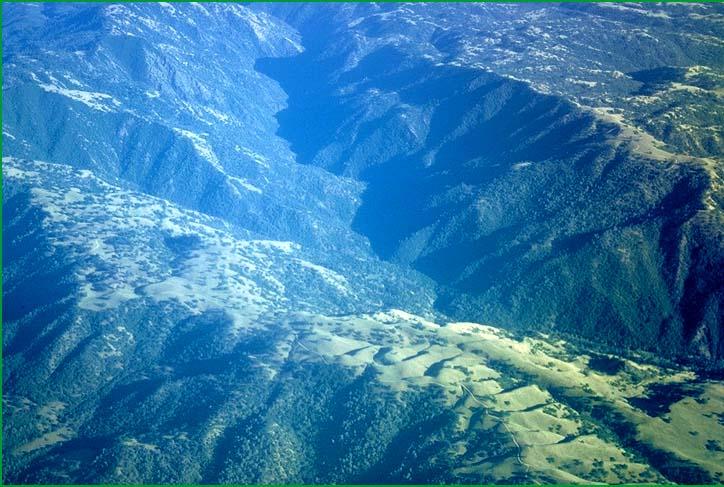
Diablo Range-aerial view of Diablo Range Ś Robert Ettner |
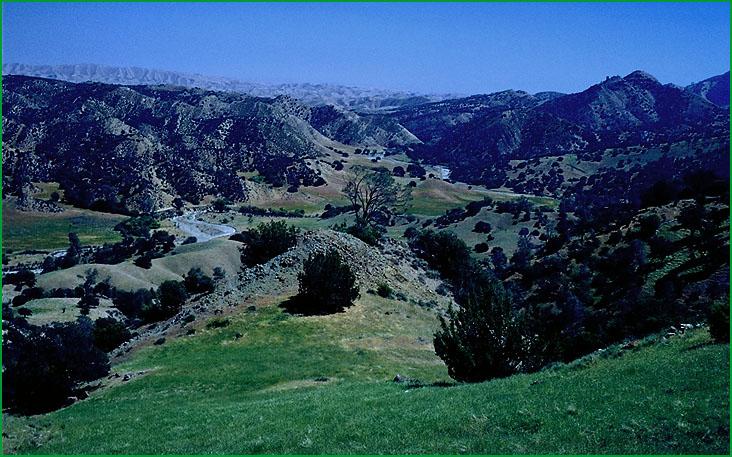
Diablo Range, Coalinga area Ś USDA |
http://www.fs.fed.us/r5/projects/ecoregions/m262aa.htm
This subsection consists of the Livermore - San Ramon Valley and hills around it, between the Greenville and the Calaveras faults, and hills southeast of Fremont that are between the Calaveras fault and the Santa Clara Valley. The climate is hot and subhumid. MLRAs 14d and 15d.
Lithology and Stratigraphy. This subsection contains mainly Miocene marine sediments along the Calaveras fault south of the Livermore - San Ramon Valley; Pliocene marine sediments in the north end of the Livermore - San Ramon Valley; Plio-Pleistocene nonmarine sediments in the south end of the Livermore Valley; and Quaternary alluvium in the Livermore - San Ramon Valley. Much of the subsection is bounded by Mesozoic rocks of the Franciscan Complex and the Great Valley Sequence, and some of those rocks are included in this subsection.
Geomorphology. This subsection includes a late Quaternary alluvial plain running east to west across the middle of the Livermore - San Ramon Valley; moderately steep hills with rounded summits north of the alluvial plain; moderately steep to steep hills with flat summits south of the alluvial plain; and moderately steep to steep hills along the Calaveras fault and between the fault and the Santa Clara Valley. The elevation range is from about 300 feet to 1200 feet in Livermore Valley and about 100 feet in the Santa Clara Valley to 2594 feet on Monument Peak northeast of the valley. Mass wasting and fluvial erosion are the main geomorphic processes.
Soils. The soils are mostly Lithic Xerochrepts and Typic Argixerolls on Miocene marine sediments; Typic Chromoxererts and Chromic Pelloxererts on Pliocene marine sediments; and Mollic Haploxeralfs and Mollic Palexeralfs on Plio-Pleistocene nonmarine sediments. On the Quaternary alluvial plain across the center of the Livermore - San Ramon Valley, the soils are Haploxeralfs, Palexeralfs, and Haploxerolls on old fans and terraces; Xerorthents and Haploxerolls in recent alluvium on the south; and Typic and Chromic Pelloxererts and Aquic Natrixeralfs in recent alluvium on the north. The older soils are leached free of carbonates, but carbonates accumulate in the subsoils of many others. The soils are well drained, except for small areas of somewhat poorly drained soils on alluvial plains. Soil temperature regimes are thermic. Soil moisture regimes are almost exclusively xeric.
Vegetation. The predominant natural plant communities are Needlegrass grasslands in the hills around Livermore Valley and, in the hills northeast of the Santa Clara Valley. Blue oak series and Needlegrass grasslands occur on south-facing slopes and Coast live oak series on north-facing slopes. Valley oak series and California sycamore series are common plant communities on recent alluvial plains.
Characteristic series by lifeform include:
Grasslands: California annual grassland series, Purple needlegrass series.
Forests and woodlands: Blue oak series, California buckeye series, California sycamore series, Coast live oak series, Valley oak series.
Climate. The mean annual precipitation is about 15 to 20 inches. Most of the precipitation is rain. Mean annual temperature is about 55░ to 60░ F. The mean freeze-free period is about 250 to 275 days.
Surface Water. Runoff to the alluvial plain is rapid and all but the larger streams are dry through most of the summer. Alluvial plain in the northern half of Livermore Valley drains slowly, and some of the soils are somewhat poorly drained. There are no natural lakes in the area, but a few reservoirs.
Subsection M262Ab
Western Diablo Range
This subsection is on mountains in the western part of the Diablo Range. They are south-southeast of the Livermore - San Ramon Valley. It is the more moist part of the Diablo Range. The climate is hot and subhumid. MLRAs 15d and 15e.
Lithology and Stratigraphy. This subsection is dominated by Franciscan sedimentary, minor volcanic, and metamorphic rocks. They are intensely folded and faulted. Also, there are some Cretaceous sedimentary rocks of the Great Valley Sequence. Ultramafic rocks are widely scattered through this subsection. There is a fairly large area of Miocene volcanic rocks, Quien Sabe volcanics, in the southern part of the subsection, east of Hollister.
Geomorphology. This is a subsection of mountains with rounded ridges, steep and moderately steep sides, and narrow canyons. Most of the mountains are aligned in north-northwest to northwest directions. The elevation range is from about 1000 feet adjacent to the Santa Clara Valley to about 4000 feet on the higher mountains (4209 feet on Mt. Hamilton). Mass wasting and fluvial erosion are the main geomorphic processes.
Soils. The soils are mostly Lithic Xerorthents, Haploxeralfs, and Argixerolls. On Miocene volcanics they are Pachic Ultic Haploxerolls, Typic Haploxeralfs, and Typic Argixerolls. Most of the soils are leached free of carbonates, but the subsoil is calcareous in some Xerolls. They are well drained. Few surfaces are old enough, because of active erosion, to have Palexeralfs. The soil temperature regimes are predominantly thermic, but mesic on north-facing slopes at higher elevation. Soil moisture regimes are xeric.
Vegetation. The predominant natural plant communities are Blue oak series on south-facing and Coast live oak series on north-facing slopes. There is some Chamise series on shallow soils, and some Live oak chaparral shrublands on shallow soils at higher elevations and on north-facing slopes. Valley oak series and Needlegrass grasslands are common in valleys. Black oak series and Mixed conifer series are inextensive, but present on some north-facing slopes at higher elevations.
Characteristic series by lifeform include:
Grasslands: California annual grassland series, Purple needlegrass series.
Shrublands: Bigberry manzanita series, California sagebrush series, Chamise series, Chamise - bigberry manzanita series, Scrub oak series, Wedgeleaf ceanothus series.
Forests and woodlands: Black oak series, Birchleaf mountain-mahogany series, Blue oak series, California bay series, Canyon live oak series, Coast live oak series, Coulter pine series, Coulter pine - canyon live oak series, Ponderosa pine series, Valley oak series.
Climate. The mean annual precipitation is about 20 to 30 inches. Most of the precipitation is rainfall, with a little snow at higher elevations. Mean annual temperature is about 52░ to 58░ F. The mean freeze-free period is about 200 to 250 days.
Surface Water. Runoff is rapid and all but the larger streams are dry through most of the summer. Natural lakes are absent, but there are a few reservoirs in the area.
Subsection M262Ac
Diablo Range
This subsection consists of the steep mountainous central part of the Diablo Range and steep hills along the east-northeast side of the San Andreas fault between Hollister and Parkfield. It stretches from the edge of Livermore - San Ramon Valley south-southeast to Parkfield. It is bounded by the San Andreas fault on the southwest, by subsection 262Ab (Western Diablo Range) on the west, and by subsection M262Ad (Eastern Hills) on the east. The climate is hot and subhumid. MLRA 5e.
Lithology and Stratigraphy. This subsection is dominated by Franciscan sedimentary, minor volcanic, and metamorphic rocks. They are intensely folded and faulted. Also, there are some Cretaceous sedimentary rocks of the Great Valley Sequence. Ultramafic rocks are widely scattered through this subsection. The largest exposure of ultramafic rocks in the southern California Coast Ranges is the New Idria ultramafic body in this subsection. Some of the rocks in the hills along the north-northeast side of the San Andreas fault are those of the Franciscan Complex and Great Valley Sequence, but most are Cenozoic sediments including Paleocene marine, Miocene marine, Plio-Pleistocene nonmarine, and Quaternary stream terrace deposits.
Geomorphology. This subsection has two quite different parts. The larger part is mountains with rounded ridges, steep and moderately steep sides, and narrow canyons. Most of the mountains are elongated in north-northwest to northwest directions. The smaller part is steep hills and narrow valleys along and parallel to the San Andreas fault. The elevation range is from about 1000 feet adjacent to the Santa Clara Valley to about 4000 or 5000 feet on the higher mountains (5248 feet on San Benito Mountain). Mass wasting and fluvial erosion are the main geomorphic processes.
Soils. The soils of Franciscan and Great Valley Sequence terrain are mostly Lithic Xerorthents, Lithic Ruptic-Xerochreptic Haploxeralfs, and Typic and Ultic Argixerolls. Those of ultramafic terrain are mostly Lithic Argixerolls, and lesser amounts of Lithic Haploxerolls and Pachic Argixerolls. Soils of Franciscan terrain along the San Andreas fault zone are mostly Typic Chromoxererts and Chromic Pelloxererts. Those on Tertiary sediments are mostly Chromic Pelloxererts and Pachic and Calcic Pachic Haploxerolls. Most of the soils are leached free of carbonates, but the subsoil is calcareous in some Xerolls. They are well drained. Few surfaces are old enough, because of active erosion, to have Palexeralfs or Palexerolls. The soil temperature regimes are mostly thermic, but are mesic on north-facing slopes at higher elevations. Soil moisture regimes are xeric.
Vegetation. The predominant natural plant communities are Blue oak series and, on shallow soils, Chamise series. There is Leather oak series on serpentine soils, and some Mixed chaparral shrublands. Sargent cypress series is present, but sparse, on serpentine soils. Also, there is some Black oak series and Mixed conifer series on north-facing slopes at higher elevations, and Jeffrey pine series on serpentine soils on San Benito Mountain.
Characteristic series by lifeform include:
Grasslands: California annual grassland series, Purple needlegrass series.
Shrublands: Bigberry manzanita series, California sagebrush series, Chamise series, Chamise - bigberry manzanita series, Deer brush series, Leather oak series, Rubber rabbitbrush series, Scrub oak series, Wedgeleaf ceanothus series.
Forests and woodlands: Black oak series, Birchleaf mountain-mahogany series, Blue oak series, California bay series, California buckeye series, California sycamore series, Canyon live oak series, Coast live oak series, Coulter pine series, Coulter pine - canyon live oak series, Foothill pine series, Incense-cedar series, Interior live oak series, Jeffrey pine series, Ponderosa pine series, Sargent cypress series, Stands on San Benito Mountain, Valley oak series.
Climate. The mean annual precipitation is about 15 to 25 inches. Most of the precipitation is rainfall, with a little snow at higher elevations. Mean annual temperature is about 45░ to 58░ F. The mean freeze-free period is about 200 to 250 days.
Surface Water. Runoff is rapid and all but the larger streams are dry through most of the summer. Natural lakes are absent, but there are a few reservoirs in the area.