 | Eastern Hills-Interior Santa Lucia Range-Gabilan Range-Kettleman Hills and Valleys |
Eastern Hills -eastern portion of unit next to San Joaquin Valley Ś Robert Ettner |
Interior Santa Lucia Range-north of San Ardo Ś Patsy Miles |
Gabilan Range-south of King City Ś Scott Miles |
Kettleman Hills and Valleys -Kettleman Hills just north of Kettleman City Ś Scott Miles |
http://www.fs.fed.us/r5/projects/ecoregions/m262ad.htm
Subsection M262Ad
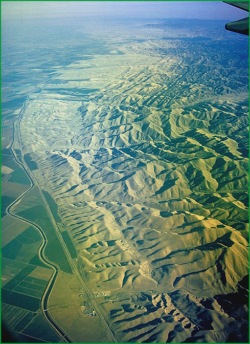
Eastern Hills
This subsection consists of hills and low mountains in the drier eastern and southeastern parts of the Diablo Range, including some hills south of the Range. It stretches from east of the Livermore - San Ramon Valley south-southeast to the Cholame Valley. The climate is hot and subhumid to arid. MLRA 15e.
Lithology and Stratigraphy. This subsection is dominated by rocks of the Franciscan Complex and the Great Valley Sequence. They are intensely folded and faulted. There are substantial areas of Eocene, Miocene, and Pliocene marine, and Plio-Pleistocene nonmarine sediments, and Quaternary alluvium.
Geomorphology. This subsection contains mostly low, steep mountains and foothills on the east-northeast edge of the Diablo Range and Avenal Ridge at the south-southeast end of the Range. At the south end, it includes moderately steep hills, and old alluvial fans along the east-northeast side of the San Andreas fault. The elevation range is from about 100 feet to about 2000 or 3000 feet on the higher mountains. Mass wasting and fluvial erosion are the main geomorphic processes.
Soils. The soils of Franciscan and Great Valley Sequence terrain are mostly Calcic Haploxerolls, Lithic Xerorthents, Entic and Typic Chromoxererts, and Chromic Pelloxererts. Those on Tertiary marine sediments are Lithic Xerorthents, Calcixerollic Xerochrepts, Calcic Haploxerolls, Typic Haploxeralfs, and Entic and Typic Chromoxererts. Those on Plio-Pleistocene nonmarine sediments are Typic Haploxeralfs, Calcic Pachic Argixerolls, and Mollic Palexeralfs. There are Fluventic Haploxerolls and Aquic Xerofluvents in recent alluvium of Cholame Valley and other valleys that are parallel to the San Andreas fault. Many of the soils are calcareous in their subsoils. They are well drained. Soil temperature regimes are thermic. Soil moisture regimes are mostly xeric, and some aridic in the southeast extreme of this subsection.
Vegetation. The predominant natural plant communities are Needlegrass grasslands. There is some Blue oak series on north-facing slopes in wetter areas and some Chamise series on shallow soils. Valley oak series is common in valleys along the San Andreas fault zone.
Characteristic series by lifeform include:
Grasslands: California annual grassland series, Purple needlegrass series, Saltgrass series.
Shrublands: Allscale series, Arrow weed series, Bladderpod - California ephedra - narrowleaf goldenbush series, California sagebrush series, Fourwing saltbrush series, Shadescale series, Spinescale series.
Forests and woodlands: Blue oak series, California juniper series, California sycamore series, Foothill pine series, Valley oak series.
Climate. The mean annual precipitation is about 12 to 20 inches. Most of the precipitation is rainfall. Mean annual temperature is about 50░ to 60░ F. The mean freeze-free period is from 225 days at higher elevations to 250 days at lower elevations.
Surface Water. Runoff is rapid and all but the larger streams are dry throughout the summer. Natural lakes are absent, but there are a few reservoirs in the area.
Subsection M262Ae
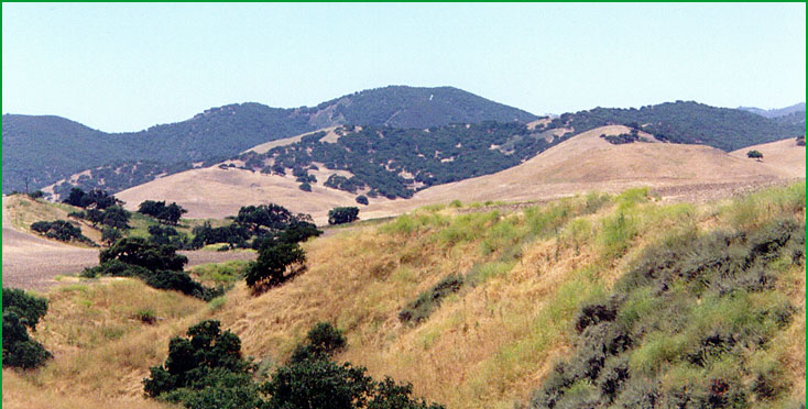
Interior Santa Lucia Range
This subsection is a steep mountainous part of the Santa Lucia Range that is far enough from the Pacific Ocean that marine effects on climate are diminished considerably. It stretches from just southwest of the Salinas Valley, near Greenfield, southeast to the Sisquoc River, east of the Santa Maria Valley. Its southwest boundary is near the Nacimiento fault. The climate is hot and subhumid. MLRA 15e.
Lithology and Stratigraphy. This subsection is predominantly Cretaceous sedimentary rocks of the Great Valley Sequence and Miocene marine sediments. It is mostly on the Salinian block. Some rocks of the Franciscan Complex are present in the south part where the subsection crosses the Nacimiento fault. A large body of granitic rock is exposed just northeast of Santa Margarita. And there are Plio-Pleistocene nonmarine sediments, Quaternary stream terrace deposits, and recent alluvium in many places, particularly along the San Antonio River.
Geomorphology. This is a subsection of steep mountains with rounded ridges, steep and moderately steep sides, and narrow canyons. Most of the mountains are elongated in north-northwest to northwest directions. The elevation range is from about 500 feet up to 4918 feet on Timber Peak in the San Rafael Mountains. Mass wasting and fluvial erosion are the main geomorphic processes.
Soils. The soils of Great Valley Sequence terrain are mostly Lithic Xerochrepts, Lithic Haploxerolls, and Mollic Haploxeralfs. Those on Miocene sediments are mostly Pachic Haploxerolls, Calcic Haploxerolls, Argixerolls, and Lithic Xerorthents. Soils on granitic rocks are shallow Typic Xerorthents, Typic Xerochrepts, and Ultic Haploxerolls. Xerorthents, Haploxerolls, Argixerolls, Palexerolls, and Palexeralfs are common on nonmarine Plio-Pleistocene sediments. Most of the soils are leached free of carbonates, but the subsoil is calcareous in some. They are well drained. Soil temperature regimes are predominantly thermic, but mesic on north-facing slopes at higher elevation. Soil moisture regimes are xeric.
Vegetation. The predominant natural plant community is Blue oak series. There is some Coast live oak series on north-facing slopes and Mixed conifer series at higher elevations. Chamise series is common on shallow soils, and soils that are very rocky or low in fertility. Mixed chaparral shrublands also occur in the unit.
Characteristic series by lifeform include:
Grasslands: California annual grassland series.
Shrublands: Bigberry manzanita series, Black sage series, California buckwheat series, California sagebrush series, California sagebrush - purple sage series, Chamise series, Chamise - bigberry manzanita series, Chamise - Eastwood manzanita series, Chamise - scrub oak series, Chamise - wedgeleaf ceanothus series, Chaparral whitethorn series, Chaparral yucca - California buckwheat series, Deer brush series, Eastwood manzanita series, Mixed sage series, Mountain-mahogany series, Mountain-mahogany - scrub oak series, Purple sage series, Red shank series, Chamise - red shank series, Scrub oak series, TuckerÆs oak series, Wedgeleaf ceanothus series.
Forests and woodlands: Bigcone Douglas-fir series, Bigcone Douglas-fir - canyon live oak series, Blue oak series, California sycamore series, Canyon live oak series, Coulter pine series, Coulter pine - canyon live oak series, Knobcone pine series, Foothill pine series, Incense-cedar series, Interior live oak series, Sargent cypress series, Tanoak series, Valley oak series.
Climate. The mean annual precipitation is about 20 to 40 inches. Most of the precipitation is rainfall, with some snow at higher elevations. Mean annual temperature is about 45░ to 58░ F. The mean freeze-free period is from 200 days at higher elevations to 250 days at lower elevations.
Surface Water. Runoff is rapid and all but the larger streams are dry through most of the summer. Natural lakes are absent, but there are a few reservoirs in the area.
Subsection M262Af
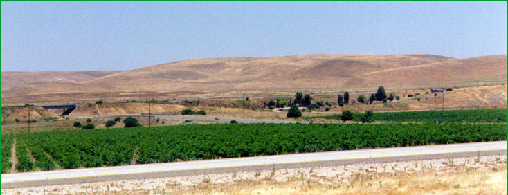
Gabilan Range
This subsection comprises the steep mountains between the San Andreas fault on the northeast and the Salinas Valley on the southwest. The climate is hot and subhumid.
Lithology and Stratigraphy. This subsection has a core of Salinian block Mesozoic granitic rock and older metamorphic rocks, mainly the Sur Series, that dominate the northwestern part of the subsection. This core of pre-Cenozoic rocks is covered by Pliocene marine, Miocene nonmarine, and upper Miocene marine sediments toward the southeast. Remnants of nonmarine Plio-Pleistocene sediments are scattered across the southeastern part of the subsection. Miocene rhyolite flow and pyroclastic rocks are exposed on a down-faulted block at the Pinnacles, near the center of the subsection.
Geomorphology. This is a subsection of steep to very steep mountains on the northwest that grade to steep to moderately steep hills on the southeast. The mountain range is much steeper on the northeast, adjacent to the San Andreas fault, than on the southwest. Therefore, the longer and larger streams drain southwest, and the have more alluvium in their valleys. Only a few streams run parallel to the San Andreas fault and the axis of the Gabilan Range. The elevation range is from about 200 feet up to about 3450 feet in the northwestern part of the range. Mass wasting and fluvial erosion are the main geomorphic processes.
Soils. The soils of granitic terrain are shallow Typic Xerorthents, Pachic Haploxerolls, Pachic Argixerolls, and Typic Haploxeralfs. Those on Miocene and Pliocene marine sediments are predominantly Calcic Haploxerolls, Typic Xerorthents and Typic Argixerolls. Chromic Pelloxererts and Pachic and Calcic Pachic Haploxerolls are common on Miocene and Plio-Pleistocene nonmarine sediments. Rock outcrop and Lithic Xerorthents dominate the Miocene volcanic terrain. The soils are generally leached free of carbonates in areas with more precipitation and mesic soil temperature regimes, but subsoils are commonly calcareous in areas of less precipitation and thermic soil temperature regimes. The soil temperature regimes are predominantly thermic, but mesic on north-facing slopes at higher elevation. Soil moisture regimes are xeric.
Vegetation. The predominant natural plant community is Blue oak series, with Coast live oak series on north-facing slopes in at least the northwestern part of the subsection. There is some Black oak series and Mixed conifer series on north-facing slopes at higher elevations. Chamise series is common on shallow soils. Needlgrass grasslands prevail on Vertisols.
Characteristic series by lifeform include:
Grasslands: California annual grassland series, Purple needlegrass series.
Shrublands: Bigberry manzanita series, California sagebrush series, Chamise series, Chamise - bigberry manzanita series, Deer brush series, Scrub oak series, Wedgeleaf ceanothus series.
Forests and woodlands: Black oak series, Birchleaf mountain-mahogany series, Blue oak series, California sycamore series, Coast live oak series, Coulter pine series, Coulter pine - canyon live oak series, Foothill pine series, Interior live oak series, Valley oak series.
Climate. The mean annual precipitation is about 12 to 25 inches. Most of it is rainfall, with a little snow at higher elevations. Mean annual temperature is about 50░ to 58░ F. The mean freeze-free period is about 200 to 250 days.
Surface Water. Runoff is rapid and all but the larger streams are dry through most of the summer. Natural lakes are absent.
Subsection M262Ag
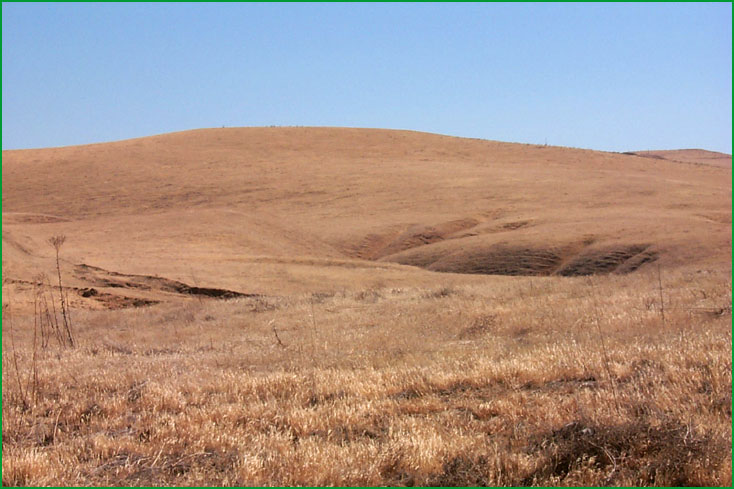
Kettleman Hills and Valleys
This subsection contains the Kettleman Hills and the Kettleman Plain. The climate is hot and arid. MLRA 17g.
Lithology and Stratigraphy. This subsection is dominated by an anticline with a core of upper Miocene and Pliocene marine sediments. Individual sections of the anticline are domes with rings of Plio-Pleistocene nonmarine sediments around the margins. A synclinal basin between anticlines is filled with Quaternary alluvium.
Geomorphology. This subsection is dominated by a low, discontinuous, northwest trending ridge that is an anticline. The discontinuous form of the ridge is reflected in the name - that is, Kettleman Hills, rather than Kettleman Ridge. Pleistocene nonmarine sediments and recent alluvial fan deposits have created a flat apron around the Kettleman Hills and a flat floor in Pleasant Valley and on Kettleman Plain. The elevation range is from about 500 to 600 feet on the fans up to about 1200 feet on the hills. Fluvial erosion and deposition are the main geomorphic process.
Soils. The soils are mostly Typic and Lithic Torriorthents on upper Miocene and Pliocene marine sediments; Typic Camborthids, Typic Halargids, and Typic Natrargids on Plio-Pleistocene nonmarine sediments; calcareous Typic Torrifluvents and Typic Torriorthents on Pleistocene nonmarine sediments; and Typic Torriorthents and Typic Haplargids on recent alluvial fans. Calcium carbonate accumulates in the subsoils, and more soluble salts accumulate in some of the soils. The soils are well drained. Soil temperature regimes are thermic. Soil moisture regimes are aridic.
Vegetation. The predominant natural plant community is the California annual grassland series.
Characteristic series by lifeform include:
Grasslands: California annual grassland series, Saltgrass series.
Shrublands: Allscale series, Arrow weed series, Bladderpod - California ephedra - narrowleaf goldenbush series, California sagebrush series, Fourwing saltbrush series, Shadescale series, Spinescale series.
Climate. The mean annual precipitation is about 6 to 12 inches. All of the precipitation is rain. Mean annual temperature is about 62░ to 65░ F. The mean freeze-free period is about 225 to 250 days.
Surface Water. Runoff is rapid and local streams are dry before summer. Streams originating in mountains west of the Kettleman Hills have water longer into the dry season, but even they dry up during the summer. There are no lakes in the area.