 | San Rafael - Topatopa Mountains-Northern Transverse Ranges-Sierra Pelona - Mint Canyon-San Gabriel Mountains |
San Rafael - Topatopa Mountains- Sespe Creek and Pine Mountain areas north of Ojai Ś Robert Ettner |
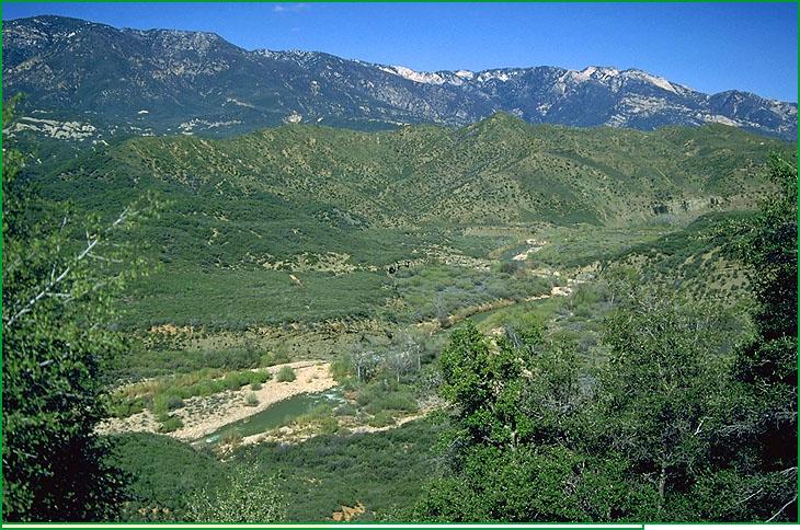
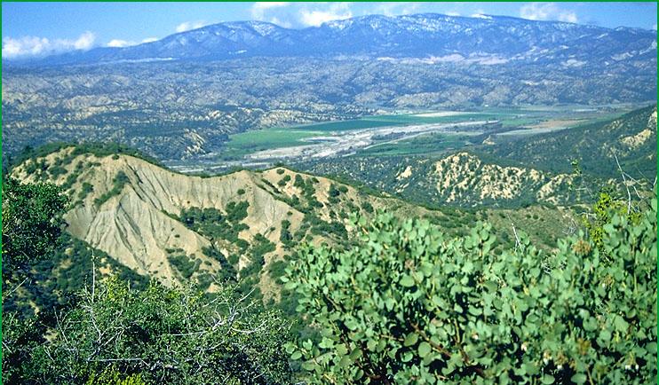
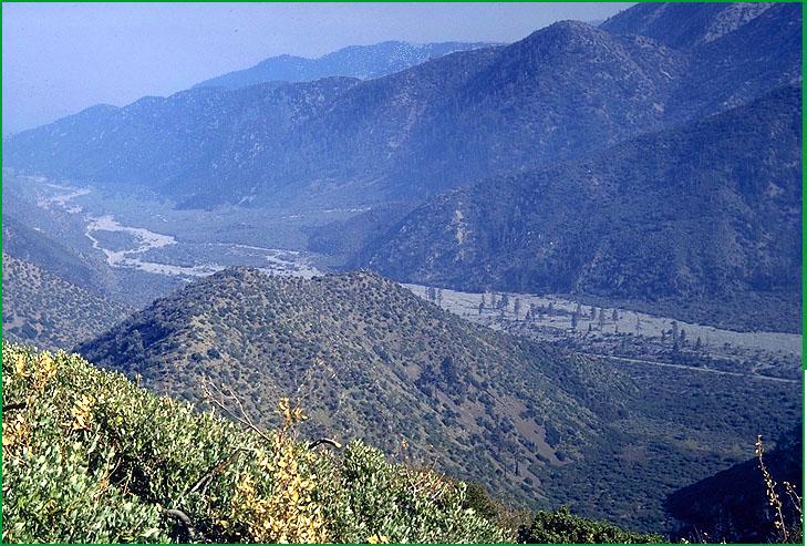
Northern Transverse Ranges-Cuyama River area north of Pine Mountain Ś Robert Ettner |
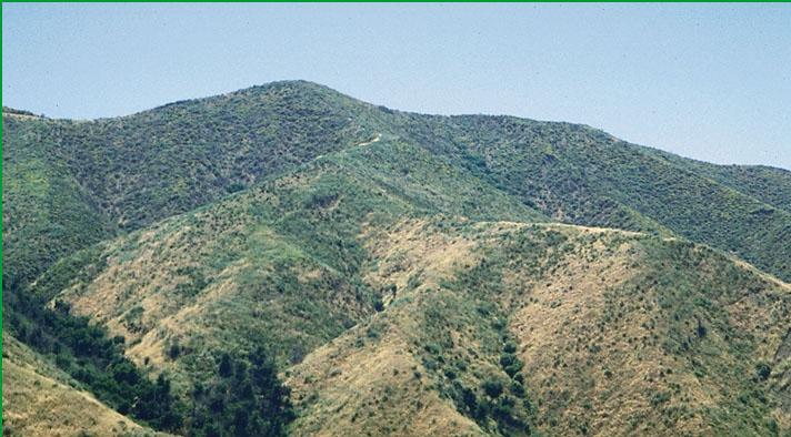
Sierra Pelona - Mint Canyon -north of Caustic Lake Ś Patsy Miles |
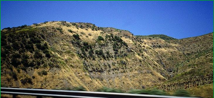
north of Caustic Lake Ś Scott Miles |
San Gabriel Mountains-North Fork Lytle Creek area near Cajon Pass Ś Robert Ettner |
http://www.fs.fed.us/r5/projects/ecoregions/m262ba.htm
Subsection M262Ba
San Rafael - Topatopa Mountains
This subsection comprises the Coast Ranges northwest of the Big Pine fault, the Transverse Ranges south of the Santa Ynez fault, and an area between the Big Pine and Santa Ynez faults, west of the Pine Mountain fault, that is a transition between the Coast and the Transverse Ranges. The climate hot to temperate and subhumid; it is modified moderately by marine influence. MLRA 20e.
Lithology and Stratigraphy. This subsection contains mainly Cretaceous, Eocene, Oligocene, Miocene, and Pliocene marine sedimentary rocks. Mesozoic rocks of the Franciscan Complex predominate southwest of the Camuesa fault, between it and the Little Pine fault.
Geomorphology. This is a subsection of steep mountains with narrow to rounded summits and narrow canyons. Mountains northwest of the Big Pine fault trend northwest, which is the common trend in the southern California Coast Ranges. Mountains south of the Santa Ynez fault trend east-west, which is the common trend in the Transverse Ranges. Mountains between the Big Pine and the Santa Ynez faults curve from a northwest trend on the north to an east-west trend on the south. The subsection elevation range is from about 1000 feet up to 7510 feet on Reyes Peak on Pine Mountain. Mass wasting and fluvial erosion are the main geomorphic processes.
Soils. The soils are mostly Typic and Lithic Xerorthents and Lithic Haploxerolls on rocks of the Franciscan formation; Typic and Lithic Xerochrepts, Lithic Haploxerolls, and Lithic, Mollic, and Ultic Haploxerolls on Cretaceous, Eocene, Oligocene, and some Miocene sedimentary rocks; and Calcixerollic Xerochrepts and Calcic Pachic Haploxerolls on Pliocene and some Miocene marine sedimentary rocks. Most, but not all, of the soils are leached free of carbonates. The soils are well drained. The soil temperature regimes are thermic at lower elevation and mesic at higher elevation. Soil moisture regimes are xeric.
Vegetation. The predominant natural plant communities include Chamise series on shallow and very stony soils, Scrub oak series, and Mixed chaparral shrublands; some Coast live oak series, California sagebrush series, and Purple sage series at lower elevations; and small areas of Bigcone Douglas-fir series and Bigcone Douglas-fir - canyon live oak series on north-facing slopes and in canyons. Mixed conifer series and Ponderosa pine series occur at higher elevations.
Characteristic series by lifeform include:
Grasslands: Beaked sedge series, Bur-reed series, California annual grassland series, Tufted hairgrass series.
Shrublands: Black sage series, California sagebrush series, California sagebrush - purple sage series, Bigberry manzanita series, California buckwheat series, California sagebrush - black sage series, Chamise series, Chamise - bigberry manzanita series, Chamise - black sage series, Chamise - Eastwood manzanita series, Chamise - wedgeleaf ceanothus series, Deebrush series, Eastwood manzanita series, Hairyleaf ceanothus series, Hoaryleaf ceanothus series, Hollyleaf cherry series, Interior live oak - canyon live oak series, Interior live oak - scrub oak shrub series, Mixed scrub oak series, Mountain-mahogany - hollyleaf cherry series, Scrub oak - birchleaf mountain-mahogany series, Parry rabbitbrush series, Purple sage series, Scrub oak series, Sumac series, Toyon - hollyleaf cherry series, TuckerÆs oak series, Wedgeleaf ceanothus series, White sage series.
Forests and woodlands: Bigcone Douglas-fir series, Bigcone Douglas-fir - canyon live oak series, Black oak series, Black cottonwood series, Canyon live oak series, Coast live oak series, Coulter pine series, Coulter pine - canyon live oak series, Incense-cedar series, Interior live oak series, Jeffrey pine series, Mixed conifer series, Ponderosa pine series, White fir series.
Climate. The mean annual precipitation is about 20 to 40 inches. Most of it is rain at lower elevations, but much of it is snow at higher elevations . Mean annual temperature is about 40░ to 60░ F. The mean freeze-free period is about 175 to 250 days.
Surface Water. Runoff is rapid. All but the larger streams and those that drain from the higher watersheds are dry through the summer. Natural lakes are absent
Subsection M262Bb
Northern Transverse Ranges
This subsection is along the south-southwest side of the San Andreas fault, both northwest and southeast of the Big Pine fault. It is on the north-northeast edge of the Transverse Ranges from the Cuyama Valley on the west-northwest to the San Francisquito Fault on the east-southeast. The climate is mostly hot to temperate, but cold at higher elevations, and subhumid. Most of the subsection is high enough that the climate is influenced by elevation more than by the Pacific Ocean. MLRA 20e.
Lithology and Stratigraphy. This subsection contains large areas of Pre-Mesozoic gneisses, Mesozoic granitic rocks, Tertiary marine and nonmarine sedimentary rocks, and Quaternary sediments. The Tertiary marine sedimentary rocks are mostly Eocene and Oligocene, and some are Miocene and Pliocene.
Geomorphology. This is a subsection with steep mountains with narrow to rounded summits and narrow canyons, although there are a few broad valleys with Quaternary to Recent alluvial plains. The mountains trend east-west, except those southwest of the Cuyama River Valley which trend west-northwest. Hills along the San Andreas fault trend west-northwest. The subsection elevation range is from about 2000 feet up to 8831 feet on Mount Pinos. Mass wasting and fluvial erosion and deposition are the main geomorphic processes.
Soils. The soils are mostly Lithic and shallow Typic Xerorthents, Pachic and shallow Entic Haploxerolls, and Typic and Pachic Argixerolls on Pre-Mesozoic gneiss and Mesozoic granitic rocks; shallow Typic Xerorthents, Typic Xerochrepts, and Mollic Haploxeralfs on Tertiary sedimentary rocks; Typic Xerochrepts, Pachic Haploxerolls, and Mollic and Ultic Haploxeralfs on Pleistocene nonmarine sediments, and Xerofluvents on Recent alluvial fans and floodplains. Most of the soils are leached free of carbonates. The soils are well drained. Soil temperature regimes are mostly thermic and mesic, with some frigid at higher elevations. Soil moisture regimes are xeric.
Vegetation. The predominant natural plant communities are California juniper series in drier areas; Jeffrey pine series and Black oak series at higher elevations; and Chamise series on shallow and very stony soils, Scrub oak series, and Mixed chaparral shrublands. Mixed sage series is common at lower elevations in the southeast side of the subsection. Canyon live oak series is common on steep canyon sideslopes. Singleleaf pinyon series is common at higher elevations than the California juniper series. Birchleaf mountain-mahogany series is common in drier areas.
Characteristic series by lifeform include:
Grasslands: Beaked sedge series, Bur-reed series, California annual grassland series, Tufted hairgrass series.
Shrublands: Big sagebrush series, Bigberry manzanita series, Bitterbrush series, Black bush series, Black sagebrush series, Bladderpod - California ephedra - narrowleaf goldenbush series, California buckwheat series, Canyon live oak shrub series, Chamise series, Chamise - bigberry manzanita series, Chamise - black sage series, Chamise - Eastwood manzanita series, Chamise - wedgeleaf ceanothus series, Deerbrush series, Eastwood manzanita series, Fourwing saltbush series, Greenleaf manzanita series, Hairyleaf ceanothus series, Holodiscus series, Hop-sage series, Interior live oak - canyon live oak shrub series, Mixed saltbush series, Mixed scrub oak series, Mountain whitethorn series, Mulefat series, Parry rabbitbrush series, Rubber rabbitbrush series, Scrub oak series, Shadscale series, Wedgeleaf ceanothus series, White sage series.
Forests and woodlands: Bigcone Douglas-fir series, Bigcone Douglas-fir - canyon live oak series, Black cottonwood series, Black oak series, Blue oak series, California juniper series, Canyon live oak series, Curlleaf mountain-mahogany series, Coulter pine series, Coulter pine - canyon live oak series, Holly leaf cherry stands, Incense-cedar series, Jeffrey pine series, Limber pine series, Mixed conifer series, Ponderosa pine series, Singleleaf pinyon series, White fir series.
Climate. The mean annual precipitation is about 12 to 30 inches. Most of it is rain at lower elevations, but much of it is snow at higher elevations . Mean annual temperature is about 40░ to 54░ F. The mean freeze-free period is about 150 to 225 days.
Surface Water. Runoff is rapid. All but the larger streams and those that drain watersheds that are at higher elevation are dry through the summer. Natural lakes are absent.
Subsection M262Bc
Sierra Pelona - Mint Canyon
This subsection includes the Sierra Pelona and a relatively low, but still mountainous, part of the north-northeastern Transverse Ranges between the Sierra Pelona and the San Gabriel Mountains. It is between the San Andreas fault on the east, the Santa Susana Mountains on the southwest, the Bee Canyon and Francisquito faults on the north, and Soledad Canyon on the south. The San Gabriel fault runs along the southwest border of the subsection. The climate is hot to temperate, and subhumid. MLRA 20e.
Lithology and Stratigraphy. This subsection has relatively large areas of Pre-Mesozoic plutonic rocks and gneisses, Mesozoic granitic rocks, Pre-Cretaceous Pelona schist, Oligocene volcanic rocks, Oligocene nonmarine and Miocene marine sedimentary rocks, Plio-Pleistocene sediments, and Quaternary alluvium.
Geomorphology. This is a subsection of steep mountains with narrow to rounded summits and narrow canyons, although there are a few broad valleys with Quaternary to Recent alluvial plains. The mountains trend east-west, but hills along the San Andreas fault trend west-northwest. The subsection elevation range is from about 1000 feet up to 5187 feet on Mount McDill in the Sierra Pelona. Mass wasting and fluvial erosion and deposition are the main geomorphic processes.
Soils. The soils are mostly Lithic and shallow Typic Xerorthents, shallow Entic Haploxerolls, and Mollic Haploxeralfs. Also, Lithic Haploxerolls are common on Pelona schist. Typic and Mollic Xerofluvents and Fluventic, Pachic, and Calcic Pachic Haploxerolls are common on Recent alluvial fans and floodplains. Most of the soils are leached free of carbonates. The soils are well drained. Soil temperature regimes are mostly thermic, with some mesic on north-facing slopes at higher elevations. Soil moisture regimes are xeric.
Vegetation. The predominant natural plant communities are Chamise series on shallow and very stony soils, Mixed chaparral shrublands, and Coast live oak series. Purple sage series and Mixed sage series occur at lower elevations, Birchleaf mountain-mahogany - California buckwheat series occurs on south facing slopes, and Bigcone Douglas-fir series and Bigcone Douglas-fir - canyon live oak series occur on north-facing slopes at higher elevations. California juniper series is common on the interior side of the mountains.
Characteristic series by lifeform include:
Grasslands: Beaked sedge series, California annual grassland series, Tufted hairgrass series.
Shrublands: Allscale series, Big sagebrush series, Birchleaf mountain-mahogany - California buckwheat series, Bitterbrush series, Black bush series, Bladderpod - California ephedra - narrowleaf goldenbush series, California buckwheat series, California sagebrush series, California sagebrush - black sage series, Chamise series, Chamise - bigberry manzanita series, Chamise - Eastwood manzanita series, Chamise - wedgeleaf ceanothus series, Chamise - white sage series, Chamise - black sage series, Cupleaf ceanothus - fremontia - oak series, Fourwing saltbush series, Hop-sage series, Mixed saltbush series, Mixed scrub oak series, Mountain whitethorn series, Mulefat series, Nolina series, Purple sage series, Scalebroom series, Scrub oak series, Shadscale series, White sage series.
Forests and woodlands: Black oak series, Birchleaf mountain-mahogany series, California juniper series, Canyon live oak series, Coast live oak series, Curlleaf mountain-mahogany series, Coulter pine series, Coulter pine - canyon live series, Singleleaf pinyon series.
Climate. The mean annual precipitation is about 12 to 20 inches. Most of it is rain, except at higher elevations. Mean annual temperature is about 45░ to 60░ F. The mean freeze-free period is about 200 to 250 days.
Surface Water. Runoff is rapid. All but the larger streams are dry through the summer. Most of the streams drain through the Santa Clara river to the ocean, but those near the San Andreas fault drain into closed drainage basins. Natural lakes are absent, except along the San Andreas fault. There are numerous sag ponds along the San Andreas fault.
Subsection M262Bd
San Gabriel Mountains
This subsection comprises the lower and warmer parts of the San Gabriel Mountains, which are between the San Andreas fault on the north-northeast and the Los Angeles and Fontana Plains on the south. It is bounded by the Soledad River valley on the northwest and the San Fernando Valley on the southwest and extend eastward to the Cajon Pass. The climate is hot to temperate, and subhumid. MLRA 20e.
Lithology and Stratigraphy. This subsection contains mostly Mesozoic granitic rocks and Pre-Cambrian anorthosite. Also, there is some Pre-Cretaceous Pelona schist.
Geomorphology. This is a subsection of steep and very steep mountains with narrow to rounded summits and narrow canyons. The mountains trend east-west, but hills along the San Andreas fault trend west-northwest. The subsection elevation range is from about 500 feet up to 6000 feet. Mass wasting and fluvial erosion are the main geomorphic processes.
Soils. The soils are mostly Lithic and shallow Typic Xerorthents, shallow Entic Haploxerolls, and Calcic Haploxerolls. Most of the soils, but not all, are leached free of carbonates. The soils are well drained. Soil temperature regimes are mostly thermic, and some mesic on north-facing slopes at higher elevations. Soil moisture regimes are xeric.
Vegetation. The predominant natural plant communities are Chamise series and Chamise - hoaryleaf ceanothus series, which are generally on shallow and very stony soils. Live oak chaparral series and Mixed chaparral shrublands also occur. Ponderosa pine series with some Bigcone Douglas-fir series and Bigcone Douglas-fir - canyon live oak series occurs on north-facing slopes, Jeffrey pine series occurs on the north-northeast side of the mountains, and California juniper series occurs on hills along the San Andreas fault.
Charac