 | Cosa - Argus Ranges - Panamint Range |
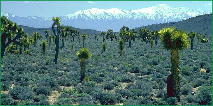
Cosa - Argus Ranges - south of Nelson Range Ś James R. Nelson |
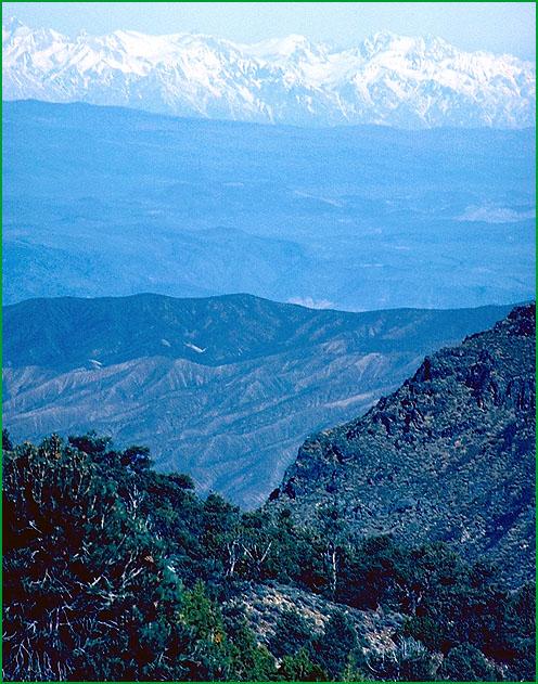
Panamint Range area, Inyo Mountains in background Ś James R. Nelson |
http://www.fs.fed.us/r5/projects/ecoregions/341fe.htm
Subsection 341Fe
Cosa - Argus Ranges
This subsection is between the Owens Valley and Panamint Valley. It includes the Coso and Argus Ranges and hills and valley between the two mountain ranges. It has a hot to temperate, arid climate. MLRA 29f.
Lithology and Stratigraphy. The bedrock is mainly Mesozoic granitic; Paleozoic marine sedimentary; Pre-Cretaceous metamorphic; and Pliocene and Pleistocene volcanic rocks. Most of the Paleozoic is represented, at least from Ordovician through Permian. The volcanic rocks are mostly basalt, but there are also some pyroclastic rocks. The Quaternary is well represented by alluvium.
Geomorphology. This subsection contains steep mountains, moderately steep hills, gently to moderately sloping alluvial fans and pediments, and nearly level floodplain and basin floor. Most of the mountains are aligned north-south, but the Darwin Hills and Santa Rosa Hills are aligned more toward the north-northwest. There are high plateaus, such as Joshua Flat at the north end of the Coso Range, that appear to be old pediments. Cinder cones are common in areas of Pleistocene volcanism. The elevation range is from about 2000 feet up to 8160 in the Coso Range and 8839 feet on Maturago Peak in the Argus Range. Mass wasting, fluvial erosion and deposition, and freeze-thaw are the main geomorphic processes.
Soils. The soils on mountains and hills are mostly Lithic Torriorthents, Lithic Camborthids, and Aridic Argixerolls, plus shallow Typic Torriorthents and shallow Aridic Haploxerolls on granitic rocks and Lithic Haplargids on volcanic rocks. Soils on alluvial fans and basin floors are mostly Typic and Xeric Torrifluvents and Torriorthents, plus Xerollic Haplargids on older alluvial fans. The soils are well drained. Soil temperature regimes are thermic and mesic. Soil moisture regimes are aridic.
Vegetation. The predominant natural plant communities, from lower to higher elevations are Creosote bush series, Mixed saltbush series, Black bush series, Big sagebrush series, and Singleleaf pinyon series. Also, Joshua tree series occurs at lower elevations.
Characteristic series by lifeform include:
Grasslands: Indian ricegrass series, Needle-and-thread series.
Shrublands: Big sagebrush series, Black bush series, Brittlebush series, Creosote bush series, Creosote bush - white bursage series, Hop-sage series, Joshua tree series, White bursage series.
Forests and woodlands: Curlleaf mountain-mahogany series, Singleleaf pinyon series, Singleleaf pinyon - Utah juniper series, Utah juniper series.
Climate. The mean annual precipitation is about 5 to 12 inches. Much of the precipitation is snow at higher elevations. Mean annual temperature is about 40░ to 66░ F. The mean freeze-free period is in the range from 125 to 250 days.
Surface Water. Runoff is rapid from alluvial fans and slow from basin floors. It drains to either Owens Valley or Panamint Valley. Streams are dry most of each year.
Subsection 341Ff
Panamint Range
This subsection comprises the Panamint Mountains, which are between Panamint Valley and Death Valley. It has a hot to cold, arid climate. MLRA 29f.
Lithology and Stratigraphy. The bedrock is mainly Precambrian sedimentary and metamorphic, Paleozoic marine sedimentary, and lesser amounts of Mesozoic granitic and Pliocene volcanic rocks. Most of the Paleozoic is represented, at least from Cambrian through Carboniferous. The volcanic rocks are mostly basalt. There is a little Quaternary alluvium in small valleys.
Geomorphology. This subsection contains steep mountains and gently to moderately sloping alluvial fans. The Panamint Range is aligned north-south. The elevation range is from about 1000 feet up to 11049 feet on Telescope Peak in the Panamint Range. Mass wasting, fluvial and deposition, and freeze-thaw are the main geomorphic processes.
Soils. The soils are mostly Lithic Torriorthents, Lithic Argixerolls, and Aridic Argixerolls, plus shallow Typic Torriorthents and shallow Aridic Argixerolls on granitic rocks and Lithic Haplargids on volcanic rocks. Soils on alluvial fans are mostly Typic Torriorthents and Xerollic Haplargids. The soils are well drained. Soil temperature regimes are mostly thermic and mesic, with frigid at higher elevations. Soil moisture regimes are mostly aridic, and some xeric.
Vegetation. The predominant natural plant communities, from lower to higher elevations are Creosote bush series, Mixed saltbush series, Shadscale series, Big sagebrush series, Singleleaf pinyon series, Limber pine series, and Bristlecone pine series.
Characteristic series by lifeform include:
Grasslands: Ashy ryegrass series, Creeping ryegrass series, Indian ricegrass series, Nebraska sedge series, Needle-and-thread series.
Shrublands: Big sagebrush series, Black bush series, Brittlebush series, Catclaw acacia series, Creosote bush series, Creosote bush - white bursage series, Hop-sage series, Low sagebrush series, Shadscale series, White bursage series.
Forests and woodlands: Bristlecone pine series, Curlleaf mountain-mahogany series, Limber pine series.
Climate. The mean annual precipitation is about 4 to 20 inches. Much of the precipitation is snow at higher elevations. Mean annual temperature is about 35░ to 72░ F. The mean freeze-free period is in the range from 100 to 275 days.
Surface Water. Runoff is rapid. It drains to either Panamint Valley on the west or Death Valley on the east. Streams are dry most of each year.