 | Gorda Ridge |
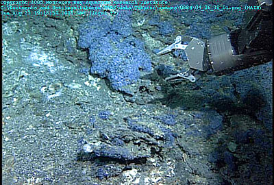
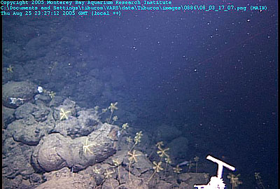
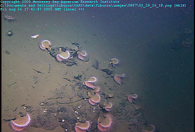
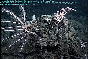
Tiburon dive 884, GR-14 vent field.Leg three is off to a great start following a highly productive dive at the Sea Cliff or GR-14 hydrothermal vent field. We dove here with Tiburon in 2000 and 2002 and collected samples of hydrothermal fluids from 305░ C vents.ROV Tiburon also collected samples of a strange material that coated the seafloor near diffuse vent areas and supported a wide variety of small animals. This material, known as ''blue munge'', is made up of colonies of microscopic protozoa. Filaments of sulfur-oxidizing bacteria that resemble Thiothrixand Beggiatoa were clinging to the tubes of the protozoa. |
tubeworms from the Sea Cliff hydrothermal vent field.a few very small Ridgeia tubeworms in this area, but most of the conspicuous vent fauna were absent, suggesting that perhaps the hydrogen sulfide levels in the vent fluids are too low to support normal chemosynthetic fauna |
A thin temperature probe (at right) attached to ROV Tiburon was used to measure the temperature of the clear, shimmering hydrothermal fluids emerging from a vent on the Gorda Ridge |
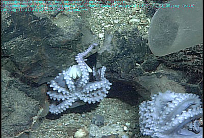
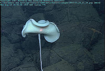
Four female octopuses brood their eggs amidst the pillow lavas of the Gorda Ridge. The lava pillow in the foreground is covered with a network of brittlestars. the octopuses were nesting |
A mother octopus broods her eggs directly in front of a small, low-temperature hydrothermal vent. We used the suction sampler to collect samples of several of her eggs for DNA analysis. |
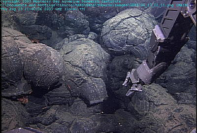
Tiburon dive 885 - 1996 lava flow on Gorda Ridge. Pillow lava often form interesting shapes. In this case, the tip of a pillow broke open, allowing a new pillow to flow out and downslope. This image from the 1996 lava flow shows very little sediment cover and few animals growing on the rocks. |
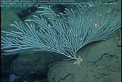
This large, graceful gorgonian coral was growing on one of the older lava flows, which have thicker sediment cover and more attached (sessile) animals |
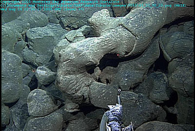
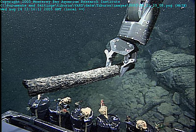
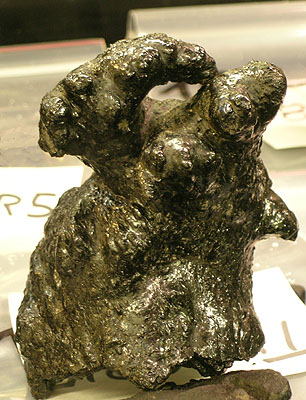
Among the experienced volcanologists on board, none had ever seen ''lava logs'' such as these, which we found lying on top of volcanic talus, like driftwood on a beach. |
ROV Tiburon collected samples of these ''lava logs'' so that we could study their texture and composition in the laboratory |
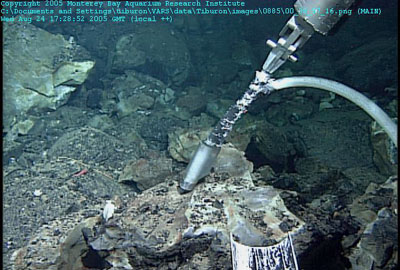
ROV Tiburon collected small samples of sediment using this glass suction sampler. We will be examining these sediment for volcanic glass and limo o Pele |
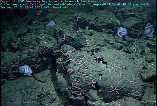
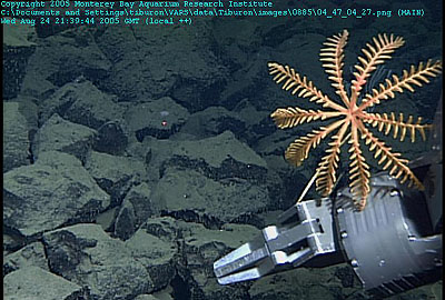
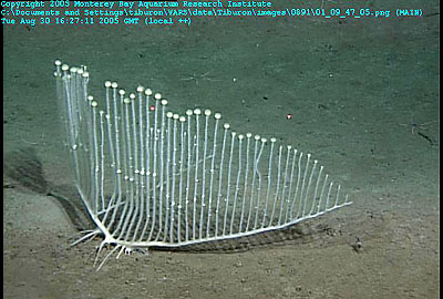
On some of the older lava flows and talus deposits, we found virtual ''gardens'' of stalked crinoids, such as this one being sampled by ROV Tiburon. |
the middle of the flow field, at roughly 42░40.650''N latitude. These pillow lava from the 1996 flow show little sediment cover, but their outer layers are rapidly peeling off. This ''breadcrust'' texture forms when new lava starts to flow into an existing pillow, causing it to expand and crack its outer shell |
On an older lava flow, we found this garden of stalked crinoids. Crinoids have lived in the oceans for hundreds of millions of years and are distantly related to sea stars |
Some of the older lava flows we saw had large sponges growing on them. This sponge grows on a stalk, perhaps because this helps it obtain more food particles from the passing currents. |
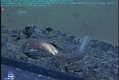
This strange, deep-sea animal is called an enteropneust. They look like worms or sea slugs as they glide along the bottom, but are in a family all of their own |
Just as geologists do on land, we used ROV Tiburon to follow the contact between the old and the new lava flows. In this frame grab, the young lava flow is on the left (with breadcrust textured pillows) and the older flow is on the right (with numerous corals and other attached animals). |
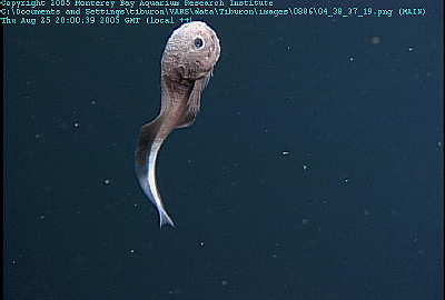
We think this is a type of snailfish, but no one on board is quite sure. It looked like a cross between a tadpole and a teddy bear |
Some rocks have ''attitude.'' This pillow-lava ''bud'' formed when the last little bit of lava pushed out the end of the pillow and froze in place |
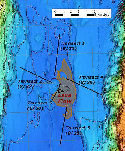
Tiburon dive 887 - Sediment sampling in Escanaba Trough. This map shows a lava flow in the northern Escanaba Trough with our sediment transect lines radiating out from it like spokes on a wheel. By taking sediment samples along each of these lines, we hope to discover what direction(s) volcanic glass was transported by currents during the eruption that created the lava flow in the center. |
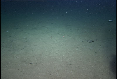
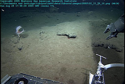
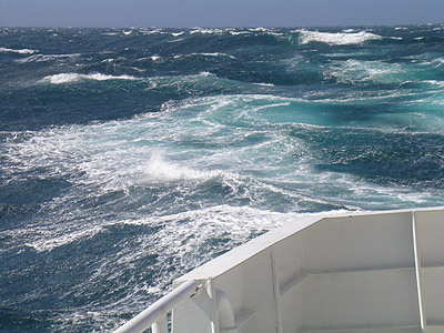
Mud. This frame grab shows a typical view from the science camera on ROV Tiburon during our sediment coring transects. Such scenery accounted for about six hours out of each fourteen-hour ROV dive. |
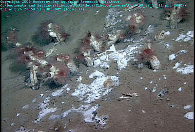
The coring went smoothly, although the dive was somewhat dull, since all we had to look at was mud, more mud, and the occasional animal residing in or on the muddy bottom. The end of the dive covered terrain with much more tectonic disruption of the sediment, so we had to spend more time searching for suitable locations to core. Along the way, we discovered two previously unknown massive sulfide outcrops and two lava flows exposed along small faults. Fixed (sessile) animals such as these flytrap anemones took advantage of any areas where hard material poked up through the sediment |
Fortunately for our sanity, the muddy bottom of the Escanaba Trough was home to a variety of interesting animals. Some of these looked familiar; others were unworldly |
Near the end of the dive, we discovered three previously unknown hydrocarbon/sulfide seeps with large living vent clams. We took samples of these clams for our colleague Bob Vrijenhoek, who will analyze their DNA to determine what species they are and how closely they are related to other vent clams at cold seeps and hydrothermal vent sites in the Pacific. We also collected samples of a white bacterial mat at one of these vent sites. Rob Zierenberg selected several samples of the hydrothermal sulfide deposits to compare to others previously studied in this area. It was an exciting end to an otherwise rather dull dive. However, we are optimistic that, once we complete the lab work, the results will help us understand the style of undersea eruptions that produce the limu o Pele fragments, We found this fairly extensive clam bed (with at least two different species of clams) in an area where black, anoxic sediments lay just beneath the sea floor. This was a reminder of home, since we see similar chemosynthetic biological communities during our dives in Monterey Bay. Many of the clams support one or more red sea anemones on their shells. At the very end of our dive, we found these huge (30-cm) chemosynthetic clams clustered around white bacterial mats, while exploring a nearly circular pit in the seafloor |
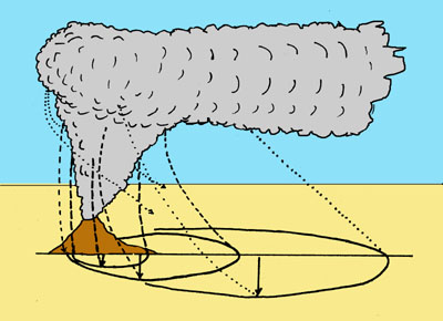
Tiburon dive 888 - Sediment sampling in Escanaba Trough - West transect. This sketch shows a volcano producing a high eruption plume - the plume spreads sideways in all directions as it rises until it is pushed over by the current (underwater) or wind (on land). The long dashed lines show the paths of the largest particles released part-way up the plume, which fall quickly to the surface and are not blown sideways much by the current. The short-dashed lines show the paths of somewhat smaller particles released further up the plume, which fall more slowly to the surface and are blown sideways a greater distance by the current. Finally the dotted lines show the paths of much smaller particles released from the top of the plume, which fall very slowly and are carried a long way by the current. The thick solid lines represent the contours on the horizontal surface of the landing points of successively smaller particles. The arrows show how the width of the deposit mimics the increasing width of the plume as it rises. |
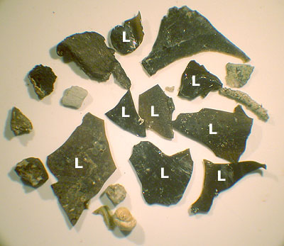
This microphotograph shows some of the coarse material from one of our cores. The largest fragment in this photo is about 8 mm across. The glassy, brown-black particles marked with the letter "L" are limu o Pele. Other particles in this core include other volcanic rocks, sediments, and the shells of tiny marine organisms called foraminiferans. looking at great piles of recently-erupted volcanic rocks with very little sediment in sight. a convenient smooth surface to collect volcanic fragments from explosive activity at a nearby vent. The vent fed a lava flow that erupted at least 300 years ago, but we have good evidence from a few samples taken during earlier work in this area that significant explosive activity was involved in the eruption. Yesterday we took about 30 samples of the surface mud during the day and analyzed some of them during the evening. These showed for sure that there are volcanic particles of the kinds we expected. So today we have been extending the area from which samples are taken to get a better idea of the pattern of particle distribution. |
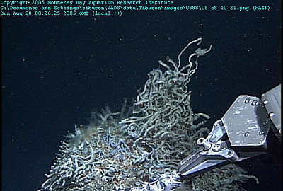
After traversing acres of mud, we were rewarded by a close-up view (and samples) of these tubeworms near the an old eruption site in the Escanaba Trough. |
Holes in the surface of an ancient lava lake such as this one (now partially covered with sediment) indicate that the lake first formed a hard crust and then partially drained as it''s upslope lava supply dwindled |
The edges of the lava flow we have been studying are sometimes partially buried in sediment, which can make it hard for us to do precise mapping. But wherever there is a hard bottom, animals such as this flytrap anemone (at left) will find and colonize it. |
Although the sediment-covered plains that we have been traversing may seem dull geologically, their inhabitants have continued to surprise and amaze us. Some of these animals are familiar but have strange shapes or living habits. Others are so enigmatic that we can''t even tell what phylum they belong to. |
Animals such as this huge (almost 1-meter-wide) brisingid sea star would not seem out of place in a science fiction movie. However, in this case, we humans are the aliens, sending our exploratory robots into their dark, watery realm |
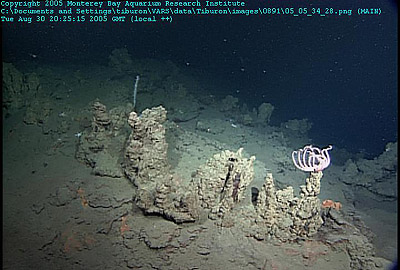
Tiburon dive 891 - Exploring the central vent area of the Escanaba Trough. The lava flow that we explored today surrounds several uplifted hills of sediment. We believe that these hills were uplifted by magma that flowed beneath the surface to form shallow sills. One of the small sediment hills was bounded by a lava-block talus slope rather than an in-place lava flow, which suggests that this particular hill was uplifted after the lava flow was emplaced. However, the fact that the flow also flowed around the hill suggests that the hill began to uplift before the emplacement of the flow around it. Taken together, these two observations provide evidence that the eruption and the local uplift caused by lava-sill emplacement occurred at about the same time. In several places we observed that the early lava flows took the form of flat, folded, or jumbled sheet flows, but later flows contained more pillow lavas. This sequence is what we would expect if large amounts of lava flowed from the vent at the beginning of the eruption, but the flow rate decreased as the eruption proceeded. This eruption pattern is common for volcanoes on land, in Hawaii and elsewhere in the world.These large pillows filled with lava that eventually developed a thick, hard crust. Later, when the pillows were refilled by a second pulse of lava, this crust cracked to form a characteristic "breadcrust" texture |
This frame grab from today''s dive shows the folded surface of a lava lake (at left), which was partially covered by pillow lavas (at right) during a later, less effusive stage of the eruption. During our transects across the lava flow, we spent a lot of time discussing what the different pillow-lava shapes and textures could tell us about the rates and styles of lava emplacement. Many of the lava pillows had thick "bread-crust" rinds. These rinds suggest that the pillows inflated slowly at first, allowing a thick crust to form, then reinflated due to a later lava surge, which caused them to split open. Other pillows were smooth-skinned |
we revisited a hydrocarbon-seep site where we had collected chemosynthetic clams in 2002. The samples from the 2002 dive smelled like diesel because they contained "cracked" hydrocarbons (essentially crude oil, which was created when hot hydrothermal fluids "cooked" the organic carbon buried in the Escanaba Trough sediments). It took us several hours to relocate the site, but when we did, all we found were dead clamshells. We also didn''t see the bacterial mats or black, hydrocarbon-rich sediments that were present in 2002. This suggests that the seep stopped flowing some time during the last 3 years. We spent several hours trying to locate this deep-sea clam community, which was first discovered in 2002. When we finally relocated the site, all we found were empty clamshells. |
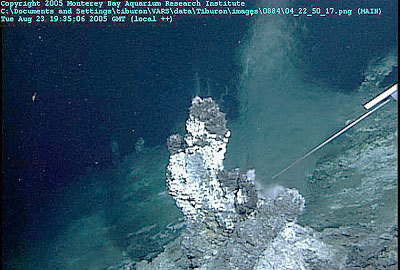
These picturesque barite mounds were very fragile and difficult to sample |
We think this graceful animal might be a type of deep-sea coral , but positive identification will have to wait until we reach shore |
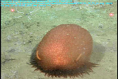
This benthic animal was about the size and shape of a cantaloupe. None of us had ever seen anything like it before |
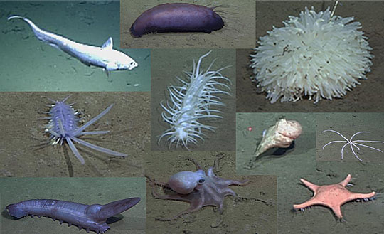
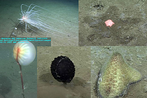
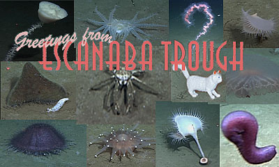
On the way back to the surface, we stopped to buy a postcard showing a few more of the animals of the Escanaba trough |
|

from MBARI -http://www.mbari.org/expeditions/ridges2005/august_23.htm
Tiburon dive 884, GR-14 vent field. Revisiting this site allowed us to assess the extent of change in the hydrothermal field. This field seems to be changing very little with similar numbers of hydrothermal vents issuing fluids at temperatures slightly above 300░ C. The vents have chosen the non-smoking section. Even though the fluids coming out of the vents are very hot, they are clear rather then ōsmoky.ö Analysis of the vent fluids in this area previously collected by our colleague Karen Von Damm at the University of New Hampshire has shown that the fluids contain low levels of dissolved metals. The reason is that the pH of the fluids is higher than in most vent fields, so they are not acidic enough to dissolve a lot of metal from the basalt volcanic rocks that underlie the vent field. Therefore, the fluids do not precipitate sulfide minerals when they emerge into cold sea water (this is what makes the black ōsmokeö that was seen above the chimneys on the Juan de Fuca Ridge during the previous leg of this cruise). The chimneys here just vent hot shimmering water.
After we completed our sampling of hydrothermal vent fauna and collected some altered volcanic rocks for analysis, we dropped down to the bottom of the vent field to see if the octopus brooding ground we observed in 2002 was still being used. In a small area with outcropping basalt rock we observed more than 40 octopuses brooding eggs. The mother octopuses fiercely guarded their eggs, but we convinced a few to move enough that we could see that there were dozens of eggs being guarded by each octopus.
The vent field where we dove today is a bit unusual, but not unique, in that it occurs in somewhat older rocks away from the spreading axis. These rocks have been moved by faulting to up above the main rift valley floor. Tomorrow we will descend into the rift valley and look at an area that erupted in 1996 forming a ridge of pillow basalts. How will the seafloor have changed since then? Will any animals have colonized the new flow?
Tiburon dive 885 - 1996 lava flow on Gorda Ridge
Today we dove with ROV Tiburon on a 1996 lava flow on the northern Gorda Ridge. This lava flow was created during a seafloor eruption that was initially detected by the Navy SOSUS hydrophone array as a swarm of earthquakes beginning on February 28, 1996. (The SOSUS array also detected recent eruptions at several of the volcanic sites that we visited earlier on this cruise, during the Juan de Fuca leg). Ten days after the earthquake swarm began, the NOAA ship McArthur made a rapid-response cruise to the area. Using water-column sampling, they located a plume of warm, gas- and particle-rich water. About five weeks later, the UNOLS ship R/V Wecoma returned to the area and continued water-column chemical surveys to locate the source of the plume.
A few months later, a third event-response cruise on the NOAA ship Discoverer recovered a float that had been inserted into the eruption plume to track its movement through the water. The following summer, the R/V Laney Chouest used the ROV ATV and the R/V Thompson used the ROV ROPOS respectively to map the lava flow. They also collected samples, which demonstrated that an eruption had indeed taken place at this site. The site has not been revisited since, although we (MBARI) dove in this general area using the Western Flyer and ROV Tiburon in 2002, in an unsuccessful attempt to locate a second hypothesized eruption site about 10 km to the south.
Our dive today was aimed at the northern part of the 1996 lava flow, where a photograph from a towed-camera used on one of the previous cruises showed black sand on old pillow talus. It was our hope that this deposit might be pyroclastic in origin, showing that the eruption was more energetic than generally thought.
We crossed to the northwest, eventually encountering older flows of pillow basalts that were rich in animal life and covered with thick sediment. Later we crossed back over the 1996 flow several times, and eventually located the previously reported gravel and sand deposits. They lie beyond an extensive talus slope at the base of a 90-m-tall overhanging cliff composed of elongate and truncated lava pillows. The gravel and sand deposits proved to be mainly glass rinds chipped from the pillows that cascaded down the talus slope. The vertical cliff of pillows and the talus slope at its base are constructional features that formed during the initial eruption, rather than by subsequent tectonic faulting or landsliding.
One of the most exciting parts of the dive was when we encountered a deposit of elongate log-shaped lava fragments, some up to at least 3 meters long, lying on the pillow talus. The pilots skillfully collected some of these "lava logs". We concluded that they were created when lava cascaded off the overhanging cliff and formed lava stalactites, which then tumbled to the talus slope below. For reasons we are still trying to understand, these "stalactites" remained intact rather than smashing when they hit the talus below.
We have been using two techniques to collect samples of millimeter-sized bubble fragments. In places where the sediment is thick enough, we use sediment push-cores. In areas of thin sediment cover, we use a small, glass suction sampler. The suction sampler was originally built to quickly sample glass rinds on large bulbous pillow lavas, where it is time-consuming to search for a rock the manipulator can handle. But we have found that we can also use this suction sampler to "vacuum" thin sediment deposits to collect samples of limo o Pele fragments.
After taking a quick look at samples from the 1996 eruption site, we know that they contain some limu fragments. However, we won''t know if this limu formed actually formed during the 1996 eruption until we chemically analyze the glass fragments using an electron microprobe.
We have already learned that the boundaries of the 1996 flow are only roughly located and that the eruption produced some novel lava forms, although few pyroclastic particles of glass. Tomorrow, we will dive on the southern part of the flow, which is virtually unexplored.
Surprisingly, we saw fresh-looking pillow lavas over only a small fraction of the approximately one-kilometer width that had been previously mapped. These flows were clearly more than nine years old as evidenced by the thin sediment layer that covered them and, more importantly, the number and variety of marine organisms that had colonized them. We were fascinated by crinoids, sponges that looked vaguely like ferns with large white balls instead of fronds, white, single-stalked, meter-long fragile gorgonians, and more exotic pink, translucent worm-shaped creatures known as enteropneusts. The geology consisted mostly of basalt pillows which ranged in shape from elongate downhill-trending tubes on sloping surfaces to more equant pillow shapes on flat ground. Fields of pillows were occasionally interrupted by talus fields, by north-trending fissures or, in one or two places, by circular drained depressions a few meters in diameter that may represent collapsed lava ponds. Most importantly, todayÆs exploration has shown us how much is yet to be learned about the extent of recent volcanism on the sea floor.
Tiburon dive 887 - Sediment sampling in Escanaba Trough
Last night we steamed to the NESCA (Northern Escanaba) site, an active hydrothermal vent site about 300 kilometers west of Eureka, California. This site was studied extensively by the U.S. Geological Survey in the 1980Æs and subsequently drilled by the Ocean Drilling Program on leg 169 in 1996. Our main interest in this area is a large (approximately 10-square-kilometer) lava flow that erupted from faults around an uplifted sediment hill, which currently supports active hydrothermal vents. We made some observations of this old lava flow during ROV Tiburon dives in 2000 and 2002, locating the eruptive vents and discovering that sediment on the uplifted hill contained significant amounts of limu o Pele and dense angular fragments of glass whose chemistry matched the adjacent lava flow.
This lava flow and eruption is relatively isolated from other volcanic sites. In addition, it sits in the midst of a plain of thick turbidite silt and mud that fills the axis of the Escanaba Trough (to a depth of 450 m). For this reason, it is an ideal site to investigate the dispersal of limu o Pele and other pyroclastic glass fragments that may have been released during the volcanic eruption. During the next five dives (over the next five days), we will attempt to measure the amount, size distribution, and morphology of the glass particles emitted during the eruption, and to find out how these characteristics vary depending on the distance and direction from the eruptive vents.
The thick sediment in this area means that we can use pushcores to sample and measure the abundance of eruption-related glass at various points on the seafloor. The glass may be moved vertically within the sediment by organisms that feed in the mud, but about 95% of the glass still resides in the upper 8 cm of the sediment, so that is how much of each core we will need to sieve to recover the glass particles. A few previous cores showed us that the maximum amount of glass occurs at a depth less than 1 cm. This information, coupled with known rates of sediment accumulation in the area, suggest that the lava flow erupted approximately 300 years ago.
We have selected 4 transects radiating out from the central eruption. Over the next few days, we will fly the ROV along each transect and collect numerous pushcores, starting about 5 kilometers away from the vent. At the farthest stations, we will stop and take cores every 250 meters, but as we approach the central vents, we will take cores more frequently. The hardest part about selecting these transects is that in some places, the seafloor is covered by lava flows and in other places the sediment has been disrupted by tectonic and magmatic processes. This means that in some cases it may be impossible to take push cores or difficult to be certain that the upper 8 centimeters of sediment has not been disturbed since the eruption occurred.
TodayÆs dive was the transect north of the eruptive vents and move south in the direction of the vents. We collected 30 pushcores, starting with 12 cores located 250 meters apart, then 5 that were 200 meters apart, then 4 that were 150 meters apart, then 5 that were 100 meters apart, and finally 4 that were only 50 meters apart. This sampling schedule was selected so that we could use the entire complement of 30 pushcores we can carry on ROV Tiburon to sample 5.3 kilometers of seafloor, with denser sampling closer to the source vent.
Any explosive eruption, on the ocean floor or on land, throws hot particles up above the vent. These heat up the surrounding fluid--water or air as the case may be--and create a convecting cloud, usually called an eruption cloud or eruption plume when it is in the atmosphere. The rise height of the plume is a direct measure of the rate at which heat is being released from the magma coming out of the vent. The plume spreads mainly in the direction of the wind (or the current, under water) but also at right angles to this direction because it gets wider as it gets higher.
In the past, eruption plumes above volcanoes on land have received all the attention, mainly because they are easy to observe. By looking at how far particles of a given size have traveled from these land-based vents, both with the wind and at right angles to it, we have worked out how high the plume went and how fast the wind was blowing for dozens of eruptions, both recent and ancient. Now we plan to do exactly the same with this submarine eruption, and work out the height of the eruption plume in the water and the speed that the current was traveling.
Oceanographers will be interested in how strong the current was when the eruption occurred, and we volcanologists will use the height of the plume to work out how fast heat was being released from the vent. The quantity of heat released in an eruption (under the ocean or on land) is proportional to the amount of magma erupted, so the heat release rate gives the eruption rate - the volume being erupted per second. So if we can survey the lava flow from this eruption well enough to get its volume, we can divide the volume by the eruption rate to get the duration of the eruption. Durations and volumes of eruptions are key pieces of information we need to help understand patterns of volcanic activity on the ocean floor.
We also collected three pushcores of areas of sediment on top of the very flat sheet flows and found that the flows were covered by about four centimeters of mud. Previous research indicates that this part of the seafloor accumulates about one centimeter of sediment every 250 to 300 years. This suggests that the these flows could be 1,000-1,200 years old--quite a bit older than our initial estimates. If this age turns out to be correct, then the hydrothermal systems in this area may be relatively long-lived, since they should have started up at about the same time as the eruption and intrusion of lava into sills within the sediment.
We have somehow been keeping up with processing all the cores, but have not really had time for more than a cursory look at the glass fragments recovered from these cores. However, we already know that limu o Pele bubble fragments as large as 8 mm across have been recovered four kilometers south of the inferred vent. Samples from our earlier dives contained smaller particles at similar distances to the north and west. Thus, it is starting to look like the main current direction during the eruption may have been from north to south. When all the samples are fully processed, we will be able to make maps of the size distributions of particles at various distances and determine how the particles were dispersed and how high into the water column they were lifted, as Lionel Wilson explained in yesterdayÆs posting.
The most precise seafloor navigation is done by deploying a network of acoustic beacons called transponders on the ocean floor. In this case, the submersible has a receiver which times the acoustic waves from the beacons. Using the velocity of sound in water (about 1500 meters per second, but it varies a bit with depth, temperature, and salinity), these sound travel-times are converted to distances. Knowing the distance from the submersible to at least 3 beacons, you can calculate the vehicle''s position by trilateration. (For each beacon, draw a circle centered at the beacon with a radius equal to the distance to the vehicle. The intersection of the circles is the location of the vehicle). This is the same way seismo