 | Grand Canyon, Arizona |
|
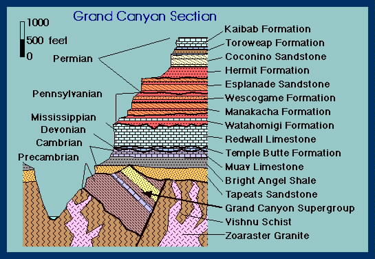
Grand Canyon crossection |
|
|
|
глубина вреза каньона более 1 км |
Grand Canyon South - http://dept.astro.lsa.umich.edu/~cowley/GCandMoon.html |
Grand Canyon South |
Grand Canyon South |
Coconino sandstone. Linear markings are from compacted sand dunes -http://dept.astro.lsa.umich.edu/~cowley/GCandMoon.html |
|
Grand Canyon south rim, sunset |
|
Grand Canyon Platea labeled |
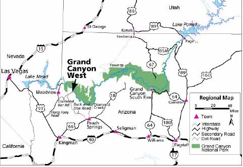
Grand Canyon west Hualapai |
Grand Canyon west |
Grand Canyon West |
Grand Canuon west |
Grand Canyon west |
Grand Canyon West, Gyano Point |
Grand Canyon west |
Uinkaret Volcanic Field, Western Grand Canyon |
Uinkaret Volcanic Field, Western Grand Canyon. A "frozen" lava falls in the inner gorge of the Grand Canyon near mile Mile 183 -http://volcano.oregonstate.edu/vwdocs/volc_images/north_america/uinkaret.html |
Uinkaret Plateau. Lava cascades near Vulcan''s Throne - http://volcano.oregonstate.edu/vwdocs/volc_images/north_america/uinkaret.html |
Vulcan''s Throne, a cinder cone, formed on the remnants of two older cones |
Devils Ramp is a lava cascade near Mile 184.8.http://volcano.oregonstate.edu/vwdocs/volc_images/north_america/uinkaret.html |
The core data, which included 57 analyses, came from nine mammillary coatings from throughout the canyon, both east and west. The results from the eastern Grand Canyon displayed faster water table descent rates than data from the western Grand Canyon which showed stable, slow drops in the water table. The data showed a slower incision rate in the western portion than the eastern.The resulting data provided a record of water table deposits as the Colorado River cut through the canyon over millions and millions of years Ц approximately 17 million for the western portion -http://research.unm.edu/quantum09/grandcanyon.cfm |


√”јЌќ (испанское guano), разложившийс¤ в услови¤х сухого климата помет морской птицы; азотное и фосфорное удобрение. Grand Canyon, Guano Point.
http://research.unm.edu/quantum09/grandcanyon.cfm
http://volcano.oregonstate.edu/vwdocs/volc_images/north_america/uinkaret.html
http://en.wikipedia.org/wiki/Guano
http://en.wikipedia.org/wiki/Bat_Cave_mine
http://www.bobspixels.com/kaibab.org/geology/gc_geol.htm
http://en.wikipedia.org/wiki/Geology_of_the_Grand_Canyon_area
http://en.wikipedia.org/wiki/Grand_Canyon
Uinkaret Volcanic Field, Western Grand Canyon
The Grand Canyon is one of the most spectacular geologic features on Earth. Few people realize that the Canyon also offers some of the most unique volcanic features in North America. These features reveal a battle between the lava flows, which cascaded into the river, making a series of dams and enormous lakes, and the power of the Colorado River, which cut through the dams to return itself to equilibrium.
The Uinkaret Volcanic Field covers about 600 square miles (1,500 square km) extending about 50 miles (80 km) north from the Colorado River. The Uinkaret volcanic field is similar to the more familiar San Francisco Peaks volcanic field near Flagstaff, Arizona. The volcanic features, basaltic cinder cones and lava flows, lie within the Canyon and on the plateaus to the north. The cones and flows have formed in the last 2 million years.
A "frozen" lava falls in the inner gorge of the Grand Canyon near mile Mile 183. View is to the northeast. The large cinder cone on the rim is Vulcan''s Throne. Lava flows near Vulcan''s Throne cascaded into the inner gorge of the Canyon and formed a lava dam. It was the most recent lava dam to form on the river. The vertical cliffs formed by lava flows are the remnants of older lava dams. Each of these dams impounded the water of the Colorado River to form a temporary lake that extended upstream
Lava cascade into Whitmore Wash. The view is looking northeast from near Mile 193. Whitmore Wash is a major tributary into the Colorado River. The flows cascades down from the Uinkaret Plateau and the Esplanade Platform. Once the lake filled behind each dam water began to cascade over the barrier. Water flowing over some of the larger dams created water falls 2,000 feet (600 m) high. Over time the water falls eroded nearly all of the barriers away, leaving only remnants of the lava dams on the walls of the inner gorge. Most of the dams were cut through by the river in less than 20,000 years.
Lava cascades near Vulcan''s Throne. View is to the northeast. The lava was erupted from a vent on the Uinkaret Plateau (not in the photo). The flows crossed the Esplanade Platform and cascaded into the inner gorge. The cascades are almost 3,000 feet (900 m) high. They cap remnants of old lava dams that form vertical cliffs as high as 600 feet (180 m) above the Colorado River.
Devils Ramp is a lava cascade near Mile 184.8. The flows on the Esplanade Platform are not part of the cascade. Lower flows, which probably moved down a tributary, spilled into the inner gorge. Erosion has removed the top of the ramp to form the cliff. It least four major lava flows cascaded down the ramp and into the Colorado River. A few days to a few thousand years were required for the development of each dam. Lakes filled behind the dam in only a matter of years. Within several hundred years the lake filled with sediment. Erosion by waterfalls could have destroyed individuals dams in less than 20,000 years.
In the last 2 million years, more than 150 lava flows have poured into the Grand canyon. These flows formed 13 major lava dams that ranged in height from 200 feet (60 m) to 2,000 feet (600 m) in height. The largest dam impounded a lake that was more than 2,000 feet (600 m) deep and had a shoreline near the base of the Redwall Limestone. Two lakes were so large that they extended into Utah and beyond the present shoreline of Lake Powell. Most of the lava dams are less than 1.2 million years old.
Up until recently, it was thought the Grand Canyon was approximately six million years old. Researchers in the Earth and Planetary Sciences at the University of New Mexico have recently contradicted this and discovered otherwise.
Using a technique called uranium-lead isotope (U-Pb) dating of water table-type speleothems or cave formations, researchers Victor Polyak, Carol Hill, and Yemane Asmerom, were able to determine the western portion of the Grand Canyon actually began to form some 17 million years ago.
That revelation, or Уeureka momentФ as Asmerom calls it, essentially proves the Grand Canyon to be three times older than originally thought.
The research, which began more than nine years ago, is funded by a grant from the National Science Foundation for $250,000 and was published recently in the journal Science. The discovery was enabled by the realization that certain cave formations, such as mammillary coatings that form near groundwater tables, provided the opportunity for researchers to date both parts of the canyon radiometrically accurately for the first time
The fact that many Grand Canyon caves contain mammillary speleothems has allowed us to take advantage of advances in U-Pb and U-series analytical techniques in an effort to make the long sought chronology possible,Ф says Polyak.
As it turned out, the caves and cave deposits, which are located throughout the Grand Canyon, were ideal in that the researchers found both pre-existing and chemical sediments deposited before, during, and after the incision of the canyon.
Naturally, the caves preserved and protected the deposits from weathering. With sufficient uranium lead ratios and yield U-Pb dates, the mammillary coatings place the water table within the canyon at a particular place and at an absolute time. The mammillary coatings allow for the incision history of the Grand Canyon to be reconstructed.
УWe knew if we could successfully determine the age of these coatings, we could position a pre-existing water table at a certain place in the canyon at a particular time,Ф
УBased on uranium-lead dates of these deposits and the positions of these deposits throughout the canyon, that the western Grand Canyon is much older than what most scientists have thought,Ф says Polyak.
УNormally what youТd expect is for the area around the headwaters to be older than what they call the Сtail of the river,Т explains Asmerom. УHere, essentially, you have a 10 million year old pre-history of the western Grand Canyon before the Colorado River became a though-flowing river to the Gulf of California
The research may provide further information that could eventually offer the possible reconstruction of the canyonТs history.
УThese results were achievable by the convergence of new technical capabilities achieved in our Radiogenic Isotope Laboratory, the conceptual breakthrough in connecting the mammillary to the water table and having samples that had sufficient uranium for dating,Ф says Asmerom.
For more information on the Radiogenic Isotope Laboratory at UNM visit: http://asmerom.unm.edu
Uinkaret Volcanic Field, Western Grand Canyon
Geology of Grand Canyon area
Grand Canuon
The geology of Grand Canyon
Grand Canyon