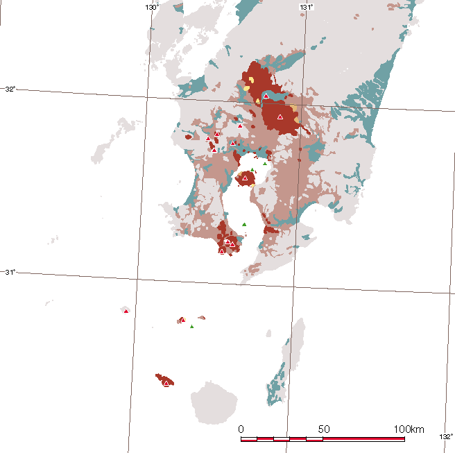
 | Kyushu and Okinawa |
|
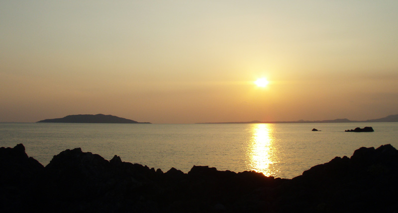
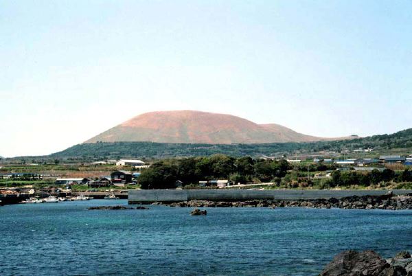
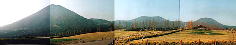
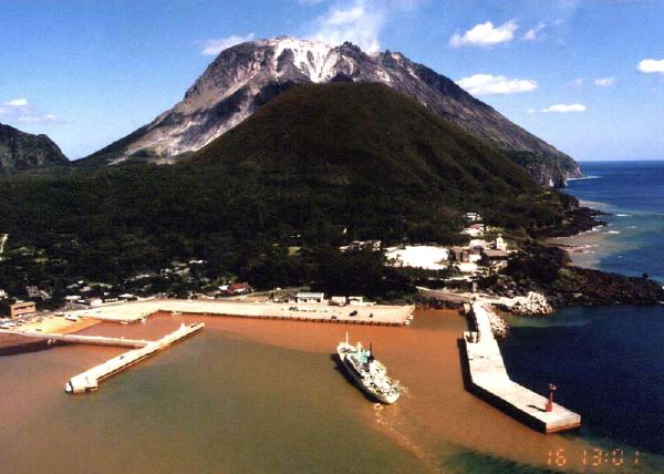
View of Kuroshima Volcano (left) and flat Tomie Volcano (right) from the NE |
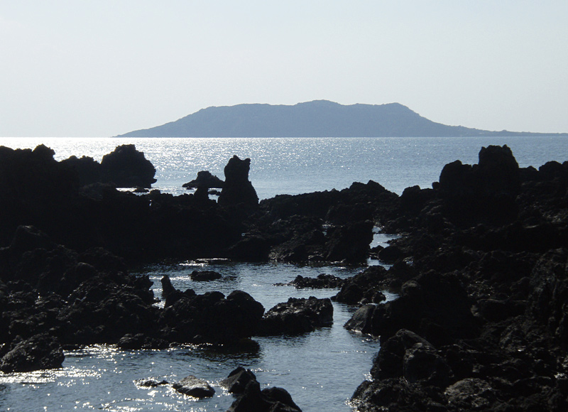
View of Kuroshima Volcano from the NNE, Abunze |
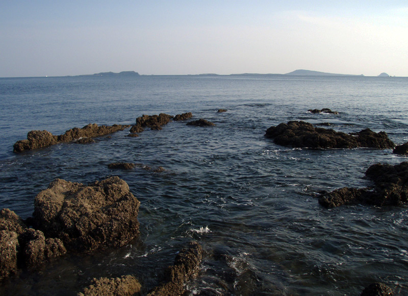
Akashima (left), Oshima (right), Oitabeshima (right foreground) and Biroshima (right end), viewed from the NNW, Kainosebana |
View of Ondake Pyroclastic Cone from the SE (Shiotsuura). |
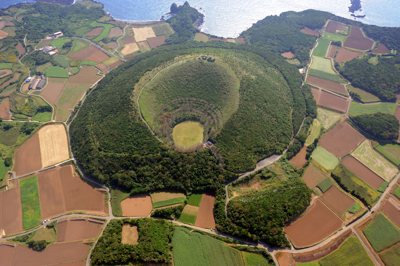
Aerial view of Midake Pyroclastic Cone as seen from the N |
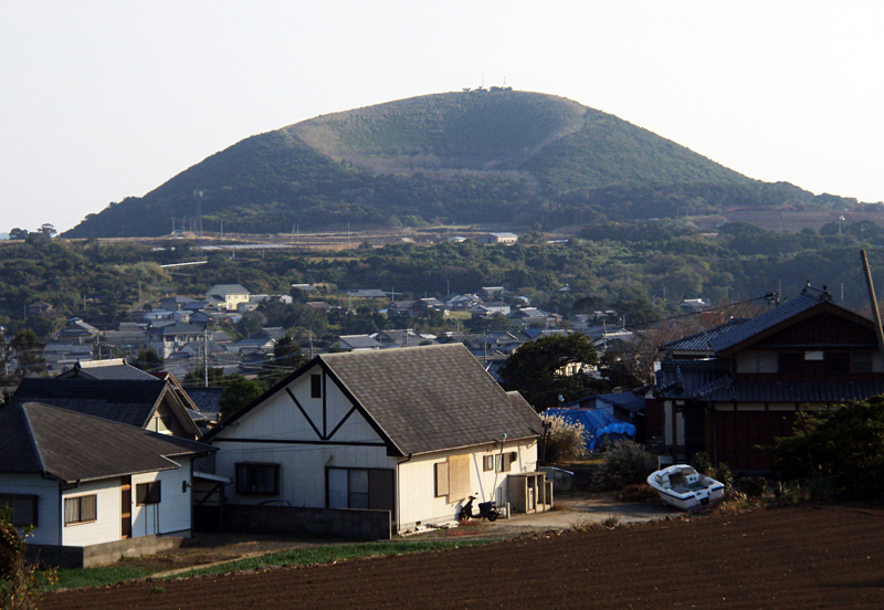
View of Midake Pyroclastic Cone from the N |
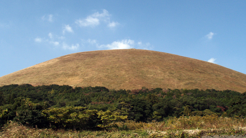
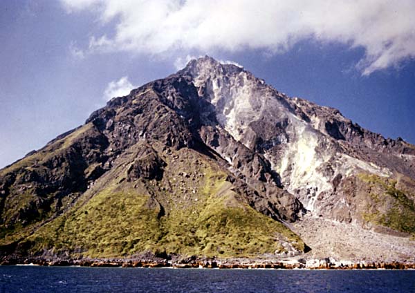
Ondake Pyroclastic Cone from the S. |
|
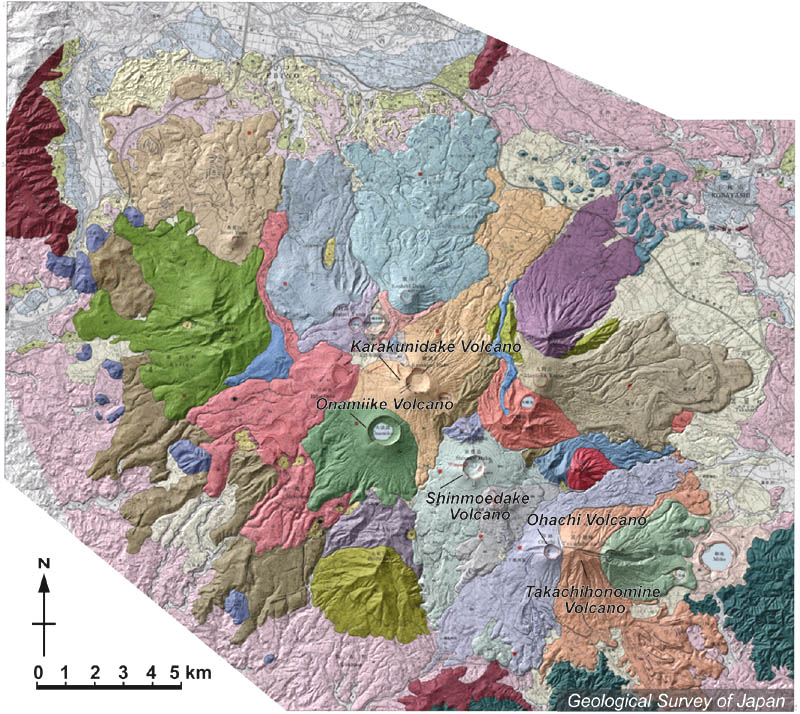
Topographic relief of Kirishima Volcano Group combined with geological map. Kirishima Volcano Group consists of several volcanic edifices. Karakunidake (pale orange) and Onamiike (pale green) volcanoes in the center. Shinmoedake Volcano (pale blue), Ohachi (pale purple) and Takachihonomine volcanoes (pale pink) in the SE |
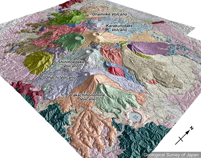
Topographic relief of Kirishima Volcano Group combined with geological map (tilted by 40° from the SE to the NW). Takachihonomine Volcano (pale pink) in the foreground is covered by Ohachi Volcano (pale purple). Karakunidake (pale orange) and Onamiike (pale green) volcanoes in the center. Note microtopography of lava flows on the flank of many volcanic edifices with well-defined crater shape. Miike Maar on the eastern flank of Takachihonomine Volcano was formed 4200 years ago. |
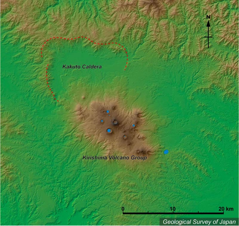
Colored topographic relief of Kirishima Volcano Group with many craters (in the S) and Kakuto Caldera (in the N). |
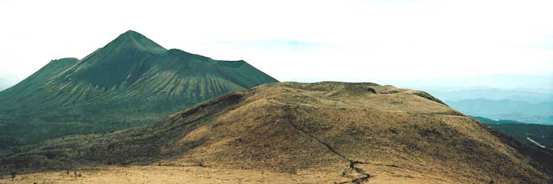
Panoramic view of Hinamoridake (left), Karakunidake (middle) and Koshikidake (right) from the NE |
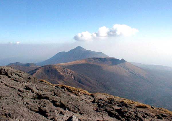
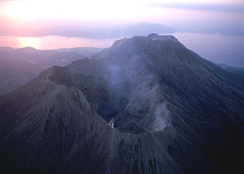
Peak of Takachihonomine (left) (with Ohachi Crater on the shoulder) and Naka-dake (foreground), as viewed from the NW (summit of Shinmoedake). |
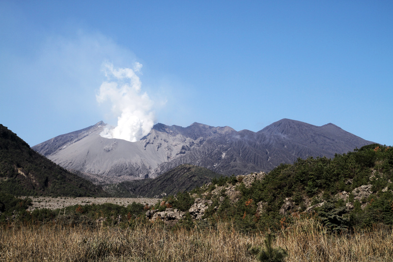
View of ShinmoeDake Volcano (center) as seen from the NW (Karakunidake) (showing crater row on the flank) and Shishikodake (left foreground). Takachihonomine in the background |
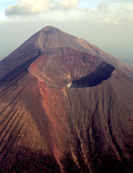
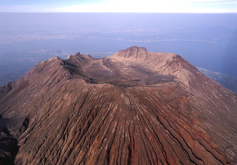
View of Takachihonomine Volcano (peak on the left) and Ohachi Volcano (right) from the WNW |
Oblique aerial view of Takachihonomine (background), Naka-dake and Shinmoedake Crater as seen from the NW |
Oblique areal view of Takachihonomine and Ohachi Crater as seen from the W |
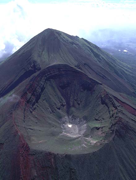
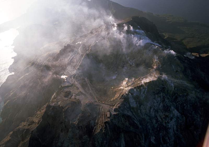
Oblique aerial view of Ohachi Crater as seen from the W showing no fumarolic activity. Takachihonomine in the background |
Summit crater of Shinmoedake viewed from the SE (highest point of crater rim) showing small crater next to crater lake |
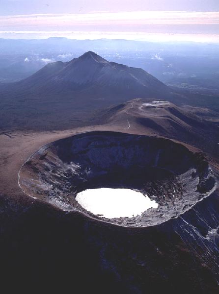
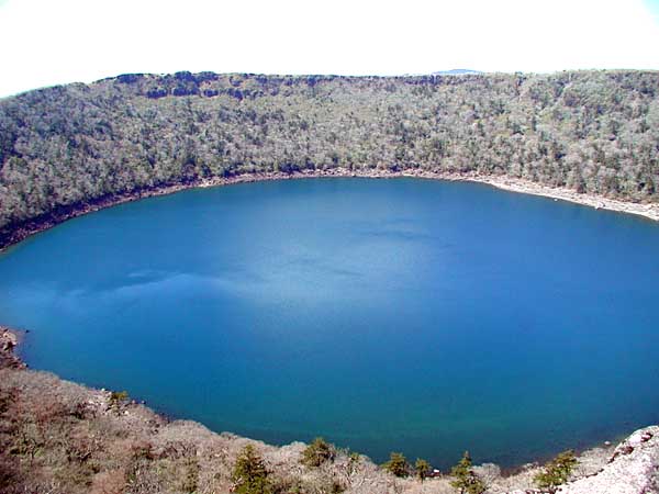
View of Onamiike Crater from the NNE (highest point of the crater rim). |
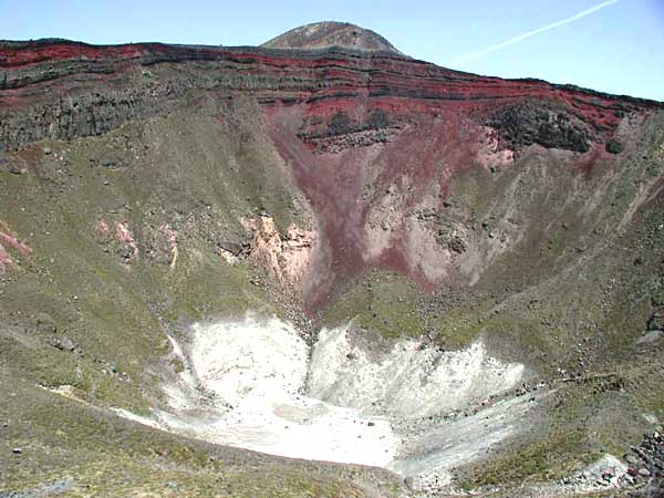
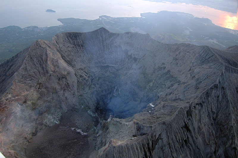
View of Ohachi Crater from the western crater rim. Peak of Takachihonomine in the background |
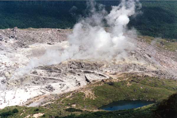
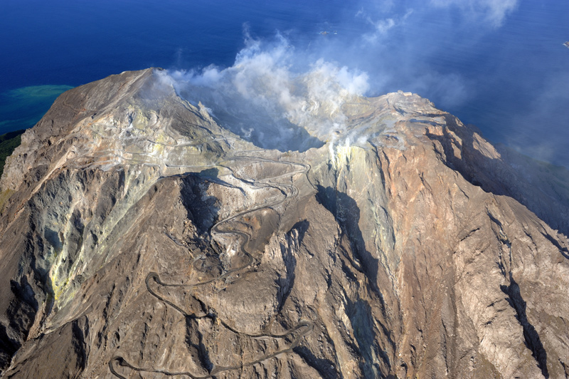
Fumarolic area of Ioyama as viewed from the SE |
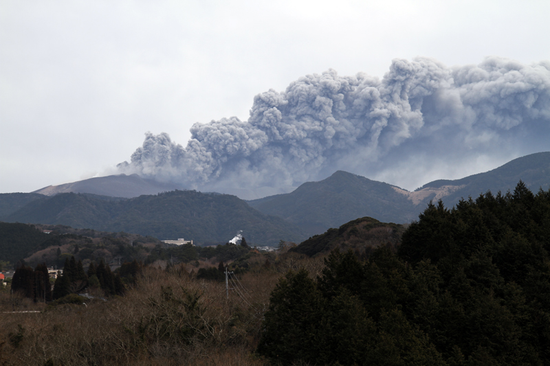
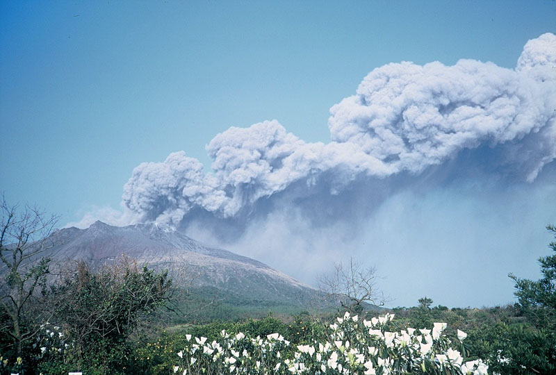
View of Shinmoedake eruption from the W |
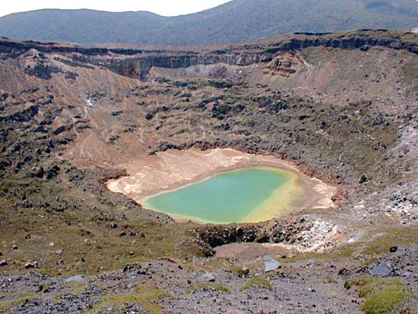
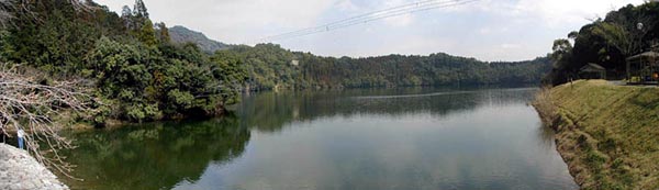
View of Sumiyoshiike Maar from the southern coast (campsite). |
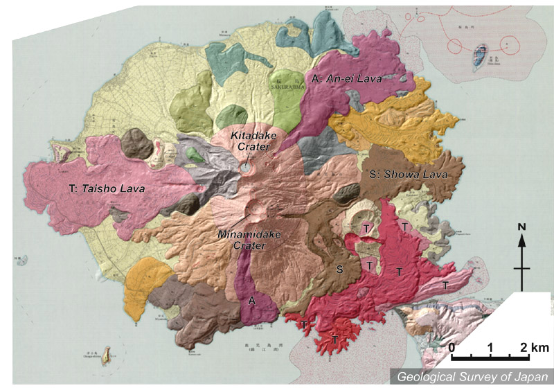
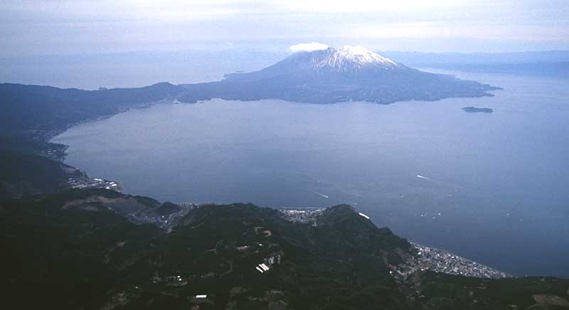
Topographic relief of Sakurajima combined with geological map. Summit craters comprise northern Kitadake and active southern Minamidake. Lava flows of 1914-915 (Taisho Lava Flow; T) that covered the W and the SE flank, bridge the island and the mainland. They are overlain by the 1946 lava flow (Showa Lava Flow). The 1779 lava flows (An-ei Lava Flow; A) erupted from lateral craters located northeast and south of the summit. An-ei and Taisho lavas both flowed into the sea. |
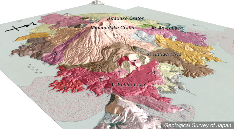
Topographic relief of Sakurajima combined with geological map (tilted by 20° from the SE to the NW). Summit craters comprise northern Kita-dake and active southern Minami-dake. Lava flows of 1914-915 (Taisho Lava Flow; T) that covered the W and the SE flank and bridge the island and the mainland, were covered by the 1946 lava flow (Showa Lava Flow). The 1779 lava flows (An-ei Lava Flow; A) erupted from lateral craters located northeast and south of the summit. An-ei and Taisho lavas both flowed into the sea. |
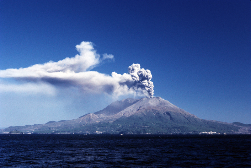
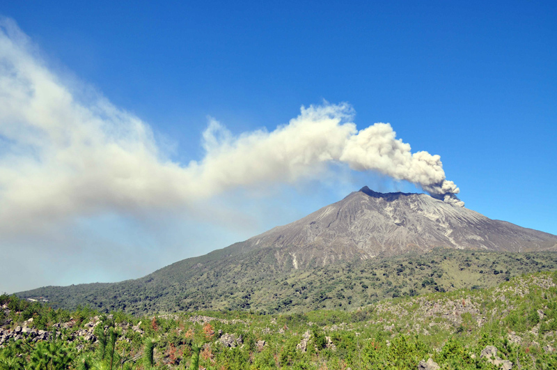
Eruption of Sakurajima Volcano viewed from the SW. |
Scene of Vulcanian eruption at Minamidake viewed from the SW. |
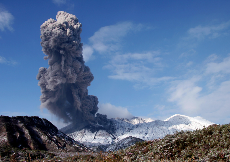
Eruption from the Showa Crater, viewed from the S |
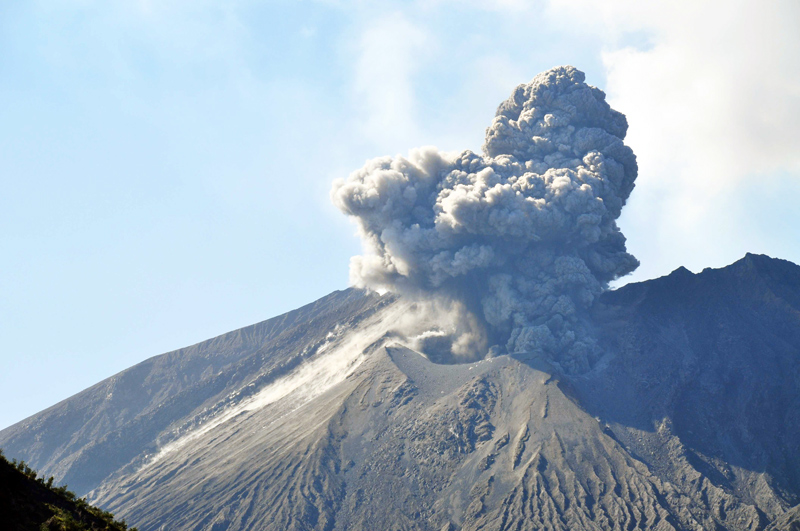
Explosion at the Showa Crater, viewed from the E. |
Small explosion at the Showa Crater, viewed from the E. |
Sakurajima Volcano viewed from the E. Around the Showa Crater are cindes |
Oblique aerial view of Kitadake Crater as seen from the E |
Oblique aerial view of Minamidake Crater as seen from the SE. Crater-B in the foreground, Crater-A in the center and Kitadake in the background. |
Oblique aerial view of Minamidake Crater as seen from the E. Buried Crater-B in the foreground and deep Crater-A in the center |
Oblique aerial view of southeastern part of Aira Caldera and Sakurajima (post-caldera volcano) as seen from the E. Niijima (Moejima) on the right side of Sakurajima. |
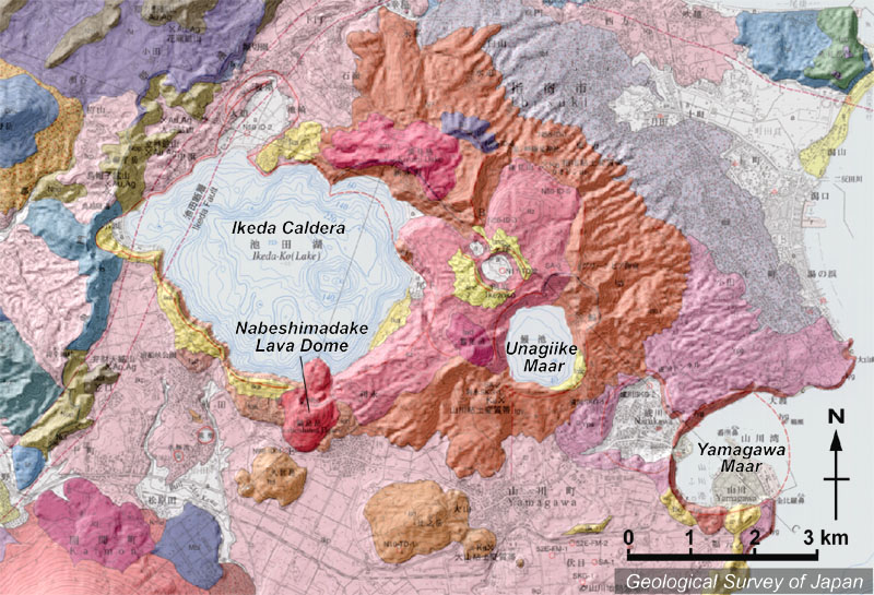
Topographic relief combined with geological map around Ikeda Volcano. The volcano, a part of Younger Ibusuki Volcanoes, consists of Ikeda Caldera, Nabeshimadake Lava Dome, Unagiike Maar, Yamagawa Maar and so on. |
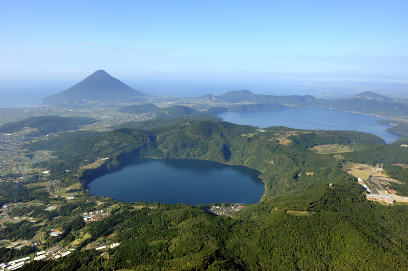
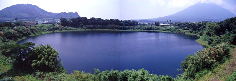
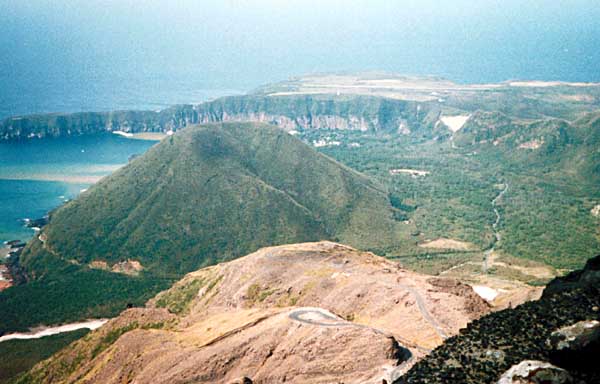
Aerial view of Ikeda Volcano as seen from the NE. Unagiike Maar in the front and Ikeda Caldera in the right back. Kaimondake Volcano in the left back |
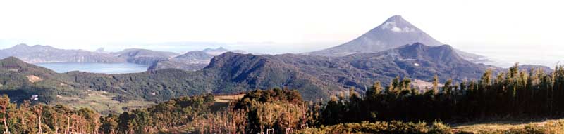
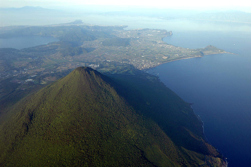
Ikeda Caldera (left) and Kaimondake Volcano (right) viewed from the NW, Mt. Oonodake |
Kagami-Ike Crater viewed from the N. Kusedake Lava Dome on the left back and Kaimondake Volcano on the right back. |
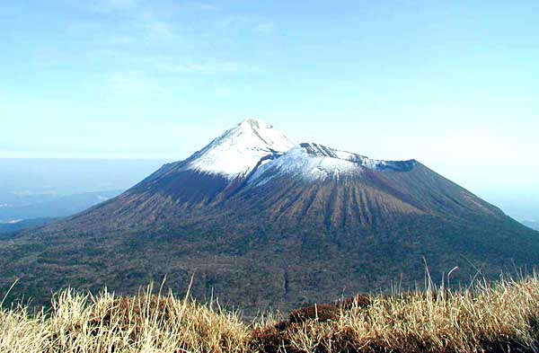
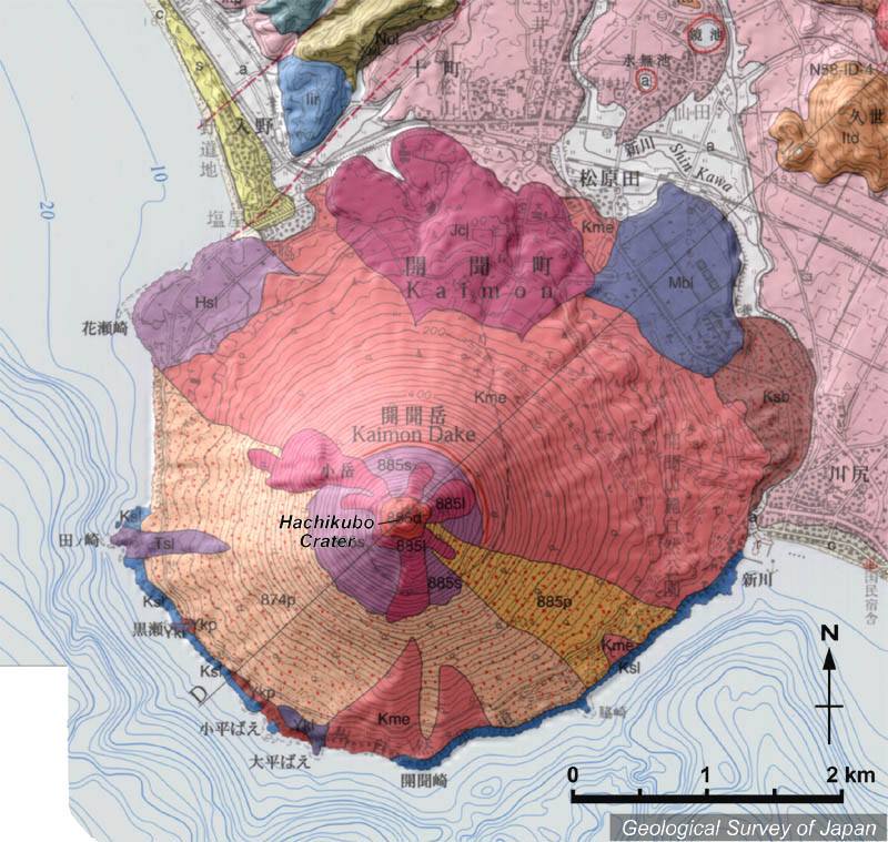
Topographic relief of Kaimondake Volcano combined with geological map. Scoria cone and lava dome erupted in 885 from Hachikubo Crater with a diameter of 1 km. The surface of the southern half of stratovolcano is covered by tephra erupted on 874 and 885 |
Aerial view of summit of Kaimondake Volcano as seen from the SW |
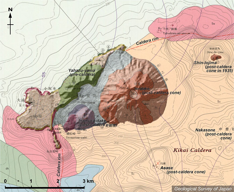
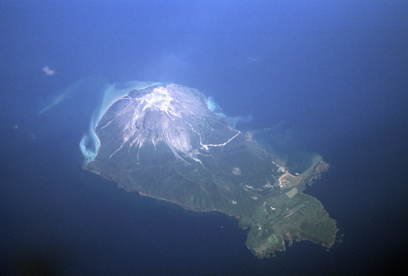
Topographic relief of Satuma Iojima Island combined with geological map. |
Aerial view of Satsuma Iojima Island as seen from the NW. |
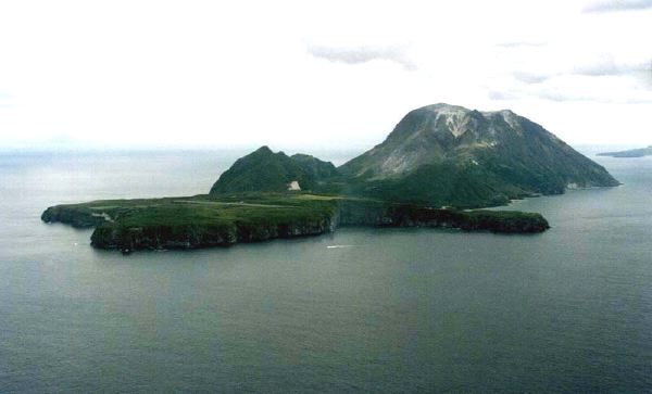
Low aerial view of Satsuma Iojima Island as seen from the SW. Io-dake (right back) is a post-caldera volcano. Yahazu-yama (in the center) and the surface (in the front) are part of pre-caldera volcanoes. |
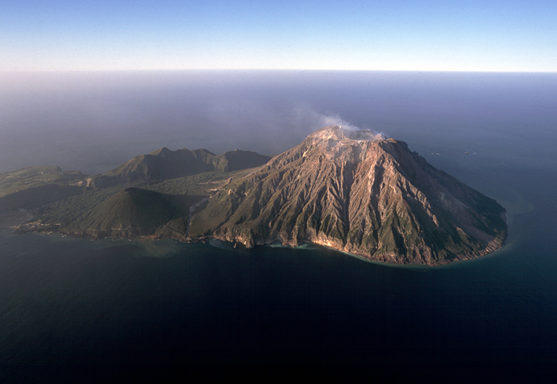
Oblique aerial view of Iodake Volcano (right) as seen from the SSE. |
Aerial view of Iodake Volcano as seen from the N |
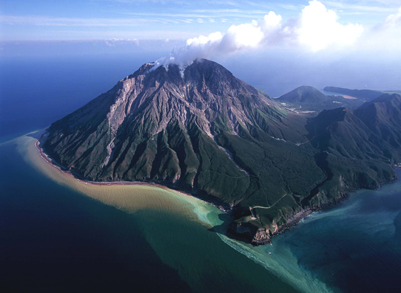
View of Iodake Volcano (in the background ) and Inamuradake Volcano (in the foreground) from W (west of Nagahama). |
Aerial vertical view of summit crater of Iodake Volcano as seen from the E. Note fumarolic activity and sulfur mine. |
Aerial view of summit crater of Io-dake as seen from the SW. |
Io-dake Volcano viewed from the SE |
Post-caldera Inamuradake Volcano (in the center) and the caldera rim (in the background) viewed from the E |
View of lava surface in Shin-Iojima. Note a person in the center |
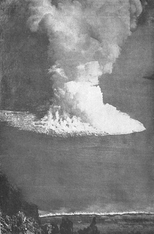
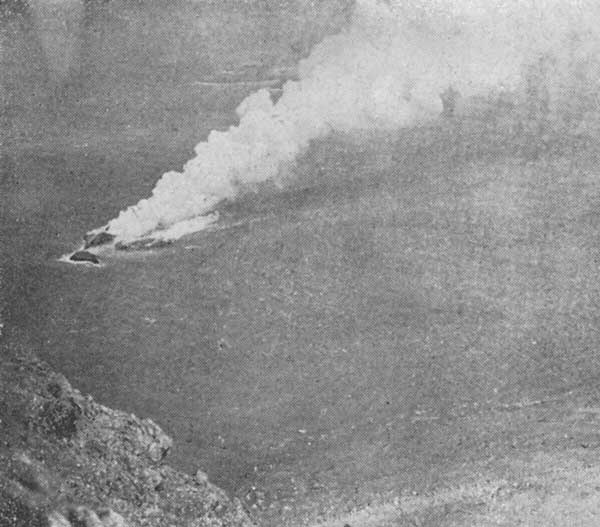
Submarine eruption occurred in October, 1934. The eruption started in September 20, and formed Shin-Iojima Island in December |
New Island (Shin-Iojima) formed by the eruption in December 1934, showing large amount of water vapor |
http://riodb02.ibase.aist.go.jp/strata/VOL_JP/EN/active_v.htm#kyushu
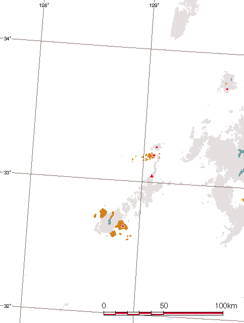
Fukue Volcano Group (ONDAKE Volcano Group), 315 m, Pyroclastic cone, lava flow, Basalt, Younger than 0.9 Ma. Most recent volcanic activity of Hino-dake: 3-2 Ka, The Fukue Monogenetic Volcano Group comprises several volcanoes including Oni-dake, Hino-dake, Shiro-dake, Kuro-shima, Ou-shima and Aka-shima volcanoes. The Fukue Volcano Group is defined as active volcanoes based on the "new active volcano definition" of Jan 2003
KIRISHIMA-YAMA, высота 1700 м (Karakuni-dake), 31 ° 55'' 51" N 130 ° 51'' 50" E, стратовулкан, пирокластический конус, лавовый купол, андезит, дацит, старший вулкан Kirishima извергался 0.3-0.15 Ма, более-молодой Kirishima моложе 0.1 Ма. Извержения:
788: Subplinian извержения (Ohachi): Лавовый поток и пирокластические потоки.
1112, 1167, 1184: Вулканическая деятельность (Ohachi).
1235: Subplinian извержения (Ohachi): Лавовый поток и пирокластические потоки.
1524, 1554: Вулканическая деятельность (Ohachi).
1566: Вулканическая деятельность (Ohachi).
1574, 1576-1578, 1585, 1587, 1588, 1598-1600, 1613-1614, 1615-1618, 1628, 1637-1638, 1659-1661, 1662-1664, 1677-1678: Вулканическая деятельность (Ohachi).
1706: Вулканическая деятельность (Ohachi).
11 марта 1716: Phreatic извержения (Shinmoe-dake): осадки из пепла и lahars.
9 ноября 1716-13 февралей 1717: Subplinian извержения (Shinmoe-dake): осадки пемзы. Пирокластические потоки.
19 Sep 1717: Subplinian извержения (Shinmoe-dake): осадки пемзы и пирокластические потоки.
1768: Вулканическая деятельность (Io-yama): поток лавы.
1771-1772: Subplinian извержения (Shinmoe-dake): осадки пемзы и пирокластические потоки.
12 января 1822: Subplinian извержения (Shinmoe-dake): осадки пемзы и пирокластические потоки.
20 апреля 1832: Вулканическая деятельность (Shinmoe-dake?).
Sep 1880: Вулканическая деятельность (Ohachi).
Май 1887, февраль и 5 мая 1888: Вулканическая деятельность (Ohachi).
Декабрь 1889, июнь 1891, ноябрь 1891, февраль 1894, июль и 10 и 18 декабря 1895: Вулканическая деятельность (Ohachi): осадки из пепла.
16 октября 1895: Вулканическая деятельность (Ohachi): осадки из пепла.
18 декабря 1895: Вулканическая деятельность (Ohachi): осадки из пепла.
15 марта 1896: Вулканическая деятельность (Ohachi).
1896-1899: Спорадическая вулканическая деятельность (Ohachi).
16 февраля 1900: Вулканическая деятельность (Ohachi).
Август и ноябрь 1903: Вулканическая деятельность (Ohachi).
Ноябрь 1914 с 1913 январями: Три вулканических извержения на Ohachi: осадки из пепла.
1923: Вулканическая деятельность (Ohachi).
17 февраля 1959: Phreatic извержения (Shinmoe-dake): осадки из пепла.
Декабрь 1991 по февраль 1992: облако из пепла: Незначительные осадки из пепла.
Группа вулканов Kirishima включает Karakuni-dake, Shinmoe-dake и Takachihonomine.
YONEMARU и SUMIYOSHI- IKE (Моногенетическая группа вулканов KAMO), высота 15 м (Yonemaru), 31 ° 46'' 20" N (Yonemaru) 130 ° 34'' 01" E, маар, базальт. Yonemaru Maar и Sumiyoshi-ike Maar имеют возраст 7 Ka, вулканические скалы Aojiki: 0.1 Ма. Yonemaru Maar, Sumiyoshi-ike Maar и скория конус Aojiki (вулканические скалы Aojiki) также называются моногенетической вулканической группой Kamo (Kobayashi и др., 2004). Yonemaru Maar и Sumiyoshi-ike Maar определены как действующие вулканы на основании "нового определения действующего вулкана" от января 2003.
Кальдера WAKAMIKO, дно кальдеры находится на глубине примерно 200 м. b.s.l., 31 ° 40'' N 130 ° 47'' E, подводная кальдера, риолит, формирование кальдеры примерно 16 Ka. Есть проявления гидротермальной активности в кальдере (называется Tagiri).
SAKURA-JIMA, высота1117 м (Kita-dake, O-take), 31 ° 35'' 20" N 130 ° 39'' 32" E, стратовулкан, андезит, dacite, активный начиная с 29 Ка. Извержения:
764: Phreatoplinian извержения: конус пемзы; поток лавы.
1471-1476: Plinian извержения: в основном осадки осадки пемзы; потоки лавы. Извержение Bummei
С 8 ноября 1779: Plinian извержения: в основном осадки пемзы; потоки лавы. Извержение.Ei
9 сентября и 31 октября 1780: Подводные извержения, сопровождаемые цунами.
11 апреля 1781: Подводные извержения, сопровождаемые цунами.
1 мая 1781 и 18 января 1782: Подводная вулканическая деятельность.
20 ноября 1785: Незначительная вулканическая деятельность: осадки из пепла.
1790, 1791, 1794, 1797, 1799: Вулканическая деятельность: осадки из пепла.
Сентябрь 1899: облако из пепла.
С 12 января 1914 (ИзвержениеTaisho): Plinian извержения: осадки из пемзы, лавовый и пирокластический поток. Остров соединился с полуостровом Osumi.
Сентябрь1935: Вулканическая деятельность: осадки из пепла.
Март 1938: облако и осадки из пепла.
Октябрь и ноябрь 1939: извержения Валканианского типа: осадки из пепла и незначительные пирокластические потоки.
Апрель-июнь 1940, апрель-июнь, август 1941, июль 1942: извержения Валканианского типа: осадки из пепла.
1943-1945: Облако из пепла.
Январь-ноябрь 1946 (Извержение Showa): извержения Валканианского типа: осадки из пепла; поток лавы 9 марта.
Июль 1948: извержения Валканианского типа: осадки из пепла.
Июнь-сентябрь 950: небольшие извержения Валканианского типа: осадки из пепла.
1954: Облако из пепла.
Октябрь 1955: извержения Валканианского типа (Minami-dake): осадки из пепла.
1956-1974: Спорадические извержения Валканианского типа : осадки из пепла.
Июнь и август 1974: Lahars.
1975-1985: Спорадические извержения Валканианского типа: выпадение пепла и частый lahars.
Апрель 1985: Незначительные пирокластические потоки.
1985-2007: Спорадические извержения валканианского типа: осадки из пепла и частый lahars.
4-20 июня 2006: извержения Валканианского типа в кратере Showa (к востоку от вершины кратера Minami-dake), а с 1946: осадки из пепла и lahars.
С 16 мая до 20 июня 2007: небольшие извержения Валканианского типа (кратер Showa): осадки из пепла. Извержение Sakura-jima – одного из пост-кпальдерных вулканов кальдеры Aira (post-Aira Caldera volcanoes). Самый высокий пик (O-take) расположен на Kita-dake. Вся недавняя историческая деятельность активизирована на вершине вулкана Minami-dake.
IKEDA (YAMAGAWA), высота 256 м (Nabeshima-dake). Поверхность озера Ikeda - 66 м над уровнем моря, и глубина - 233 м, 31 ° 13'' 53" N (наиболее глубокое место озера Ikeda) 130 ° 33'' 59" E, кальдера, лавовый купол, маар, риолит, дацит, андезитю Вулкан Ikeda имеет возраст 5.7 Ka, Nabeshima-dake: 4.3 Ka. Вулкан Ikada – небольшой кальдерный вулкан поперечником 4 км и является частью группы вулканов Ibusuki. Сформировалось несколько маар, включая Unagiike Maar, Ikezoko Maar, Matsugakubo Maar, Narukawa Maar и Yamagawa Maar. Nabeshima-dake – молодой лавовый купол. Лавовые купола также находятся в озере Ikeda. Вулканы Ikeda и Yamagawa определены как действующие вулканы на основании "нового определения действующего вулкана" от января 2003
KAIMON-DAKE (SATSUMA FUJI), высота 922 м, 31 ° 10'' 36" N 130 ° 31'' 50" E, стратовулкан, лавовый купол, базальт, андезит, моложе 4 Ka. Извержения:
Примерно Ka: Subplinian извержение: Scoria fall.
7-е столетие: Subplinian и phreatomagmatic извержения: Scoria fall.
29 марта 874: Subplinian извержение: Scoria fall и lahar.
Август, сентябрь: Subplinian извержения: Scoria fall ; лавовый купол.
SATSUMA IOJIMA (KIKAIJIMA, TOKARA IOJIMA), высота 704 м (Io-dake), 30 ° 47'' 22" N 130 ° 18'' 27" E, стратовулкан, пирокластический конус, лавовый купол, андезит, базальт, риолит, активный начиная с 5.2 Ka до1.6 Ka: извержения Валканианского типа (Io-dake): осадки из пепла и пирокластические потоки.
1.3 Ka: извержения Валканианского типа (Io-dake): осадки из пепла и пирокластические потоки.
Сентябрь-ноябрь 1934: Подводное извержение (на расстоянии 2 км от берега на востоке):раскиданы пемзовые лапилли.
7 декабря 1934 - март 1935: Новый остров появился (Shin-Io-jima): лавовый поток.
Апрель-ноябрь 1998: облако и осадки из пепла.
Мочь-август 1999: облако и осадки из пепла.
Январь, март, октябрь-декабрь 2000: облако и осадки из пепла.
Февраль, апрель-декабрь 2001: облако и осадки из пепла.
Мочь-июль 2002: облако из пепла.
Февраль, апрель-октябрь 2003: облако из пепла (вершинный кратер): осадки из пепла.
Март-апрель, июнь, август-октябрь 2004: облако из пепла (вершинный кратер): осадки из пепла.
Satsuma Io-jima включает три вулкана посткальдерной фазы кальдеры Kikai: Inamura-dake, Io-dake и Shin-Io-jima. Основная фумарольная деятельность сосредоточена на саммите Io-dake. Зарегистрированы мелкие подводные извержения вокруг островов.