 | УДЗУ-МАРИАHСКАЯ СИСТЕМА ДУГ: Mарианские острова |
http://www.vulkaner.no/v/volcan/submarin/mariana-arc.html |
|
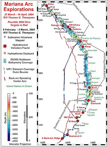
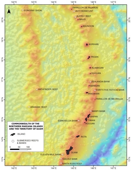
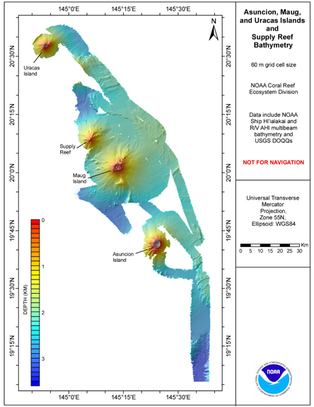
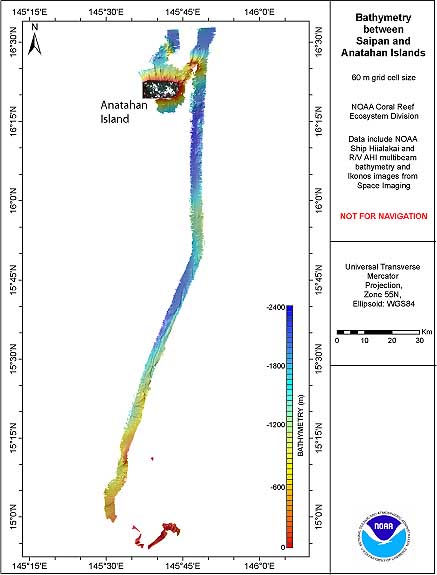
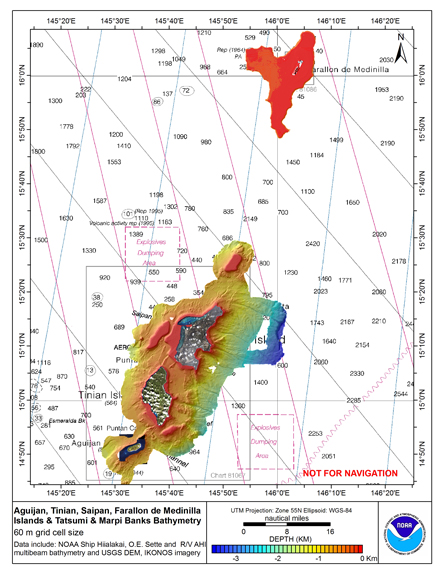
Mapping - http://www.soest.hawaii.edu/pibhmc/pibhmc_cnmi.htm |
Mariana Trench expedition http://www.ouramazingplanet.com/2658-mariana-trench-expedition-peers-deep-earth.html |
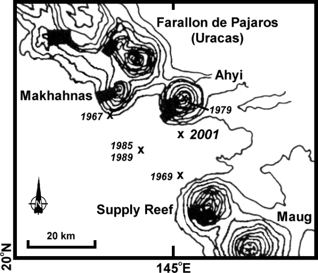
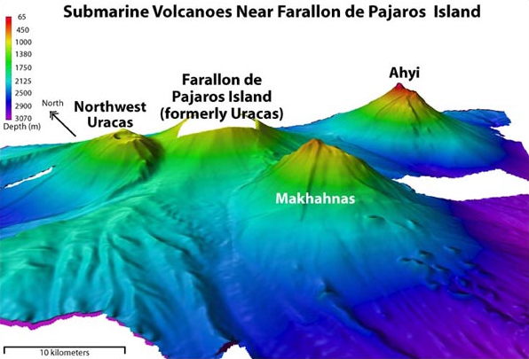
Ahyi seamount, -137m, is a large conical submarine volcano that rises to within 137 m of the sea surface about 18 km SE of the island of Farallon de Pajaros (Uracas) in the northern Marianas. Water discoloration has been observed over the submarine volcano, and in 1979 the crew of a fishing boat felt shocks over the summit area of the seamount followed by upwelling of sulfur-bearing water. On April 24-25, 2001 an explosive submarine eruption was detected seismically from a seismic station on Rangiroa Atoll, Tuamotu Archipelago. The event was well constrained (+/- 15 km) at a location near the southern base of Ahyi; the summit of the seamount lies within the location uncertainty- http://www.volcano.si.edu/world/volcano.cfm?vnum=0804-141 |
|
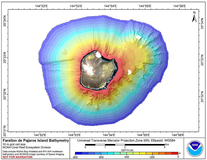
Farallon de Pajaros Island, H=360m -http://www.soest.hawaii.edu/pibhmc/pibhmc_cnmi_fdp_bathy.htm |
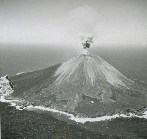
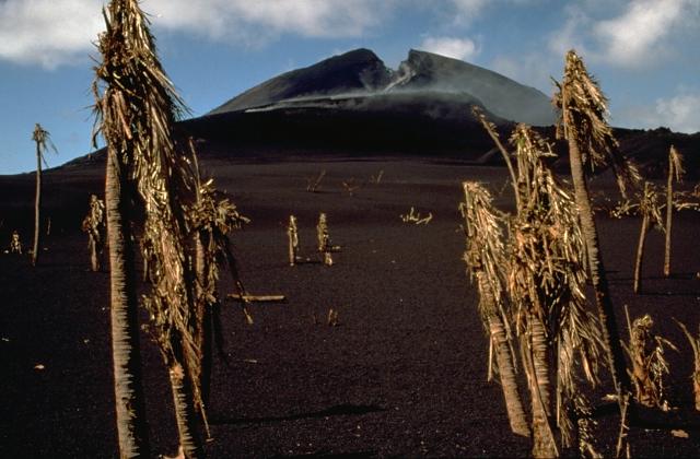
Explosive activity was frequently observed from Farallon de Pajoras volcano in October and November 1952. Lava flows were emplaced on the east and west sides of the summit in February-March 1953. This 1953 photo from the east shows an eruption plume rising above the summit crater and lighter-gray lava flows in the center that were erupted in 1953. The lobe just left of center eventually reached the coast. Explosive activity continued until April 15. The steep-sided peak at the SE coastline is a remnant of an older caldera.Last eruption 1967- http://www.volcano.si.edu/world/volcano.cfm?vnum=0804-14= |
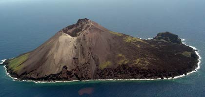
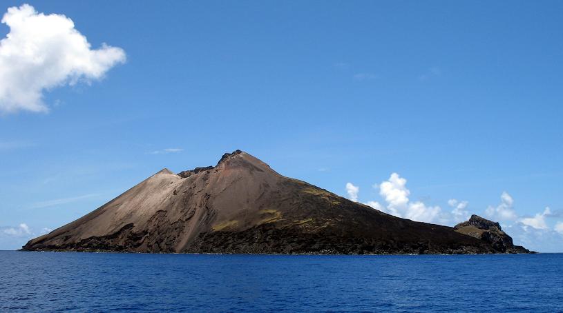
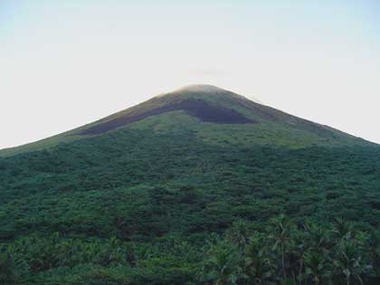
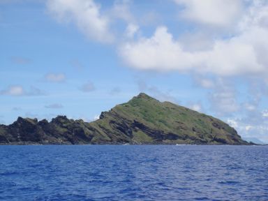
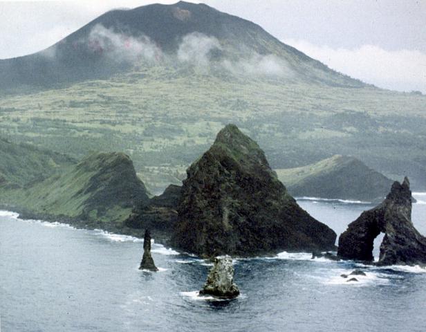
Farallon de Pajaros, also called Uracas, about 2-km in diameter. It has erupted at least 16 times since 1864, most recently in 1967. Most eruptions are explosive. About half of them produced lava flows. Some are on the submarine flanks of the volcano, it keeps its steep slopes smooth by frequent flows of lava and ash. The summit is crowned with white sulfur and at times, dense clouds of yellow smoke and fire issue from the crater. The southwest and west shores are precipitous and bare. Human impact: uninhabited, seldom visited . Ecosystems: recent colonizers of fresh volcanic materials. Special features: active volcano, several recent eruptions including 1943; seabird rookery. http://www.guam.net/pub/sshs/depart/science/mancuso/marianas/uracas/uracas.htm |
Farallon de Pajaros -http://en.wikipedia.org/wiki/Farallon_de_Pajaros The small 2-km-wide island of Farallon de Pajaros (also known as Uracas) is the northernmost and most active volcano of the Mariana Islands. Its relatively frequent historical eruptions dating back to the mid-19th century have caused the andesitic volcano to be referred to as the "Lighthouse of the western Pacific." The symmetrical, sparsely vegetated summit is the central cone within a small caldera cutting an older edifice, remnants of which are seen on the SE and southern sides near the coast. Flank fissures have fed lava flows during historical time that form platforms along the coast. Both summit and flank vents have been active at Farallon de Pajaros during historical time. Eruptions have also been observed from nearby submarine vents, and Makhahnas seamount, which rises to within 640 m of the sea surface, lies about 10 km to the SW - |
The small island stratovolcano of Farallon de Pajaros (Uracas) is surrounded by a series of lava flows erupted during historical time. This 1980 photo from the SE shows a blanket of unvegetated lava flows at the left that diverted around the prominent vegetated peak at the lower right. It is a remant of a caldera created prior to the formation of the present cone.http://www.volcano.si.edu/world/volcano.cfm?vnum=0804-14= |
Farallon de Pajaros crater http://www.eri.u-tokyo.ac.jp/fmaeno/PHOTOS/mariana2.html |
Farallon de Pajaros |
Supply Reef (-8m) is a hydrophonic conical submarine volcano in the northern Mariana Islands that rises to within 8 m of the sea surface. The andesitic seamount lies about 10 km NW of the Maug Islands, the emergent summit of a submarine volcano that is joined to Supply Reef by a low saddle at a depth of about 1800 m. Supply Reef was mapped as Quaternary; living corals on the crater rim suggest that the volcano is either dormant or extinct (Corwin, 1971). Several submarine eruptions have been detected by sonar signals originating from points very approximately located at distances of 15-25 km NW of Supply Reef. http://www.volcano.si.edu/world/volcano.cfm?vnum=0804-142 |
Eifuku volcano. Champagne Vent Hirez:The Volcanic Unit consists of small circles (2.3 miles in diameter) around 21 undersea mud volcanoes and thermal vents along the Mariana Arc, again only the submerged lands. The Islands Unit includes only the waters and submerged lands of the three northernmost Mariana Islands, Farallon de Pajaros or Uracas, Maug, and Asuncion, below the mean low water line |
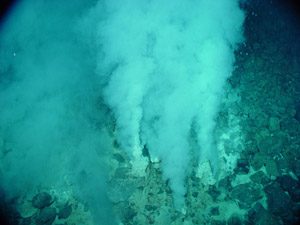
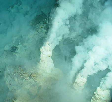
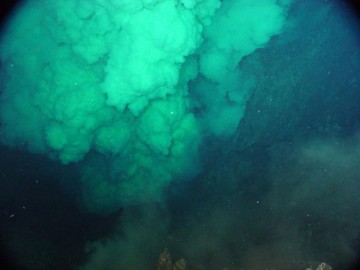
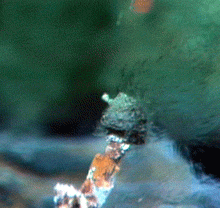
White chimneys at Champagne vent site, NW Eifuku volcano. The chimneys are ~20 cm across and ~50 cmhigh, venting fluids at 103oC). During the first dive at NW Eifuku volcano, a remarkable hydrothermal site was discovered near the summit,1,650 m below sea level. Small white chimneys vented cloudy white fluid at the site. Surprisingly, bubbles composed of some sort of fluid were rising out of the sediment around the chimneys. Bubbles have been seen before in hydrothermal systems, but never in such great abundance. http://www.vulkaner.no/v/volcan/submarin/mariana-arc.html |
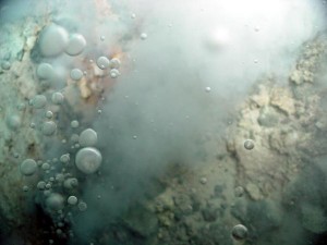
Close-up of bubbles at the Champagne Vent.It’s obvious why the site was named “Champagne”. The bubbles were slightly opaque, only barely buoyant,and sticky, adhering to surfaces on the ROPOS ROV (the camera-robot). The bubbles also differed from typical gas bubbles in that they had little tendency to fuse into larger bubbles, even when touching each other. These fluids want to expand over 50 times in volume as the ROV ascends to the surface, because the confining weight of seawater pressure is removedhttp://www.vulkaner.no/v/volcan/submarin/mariana-arc.html |
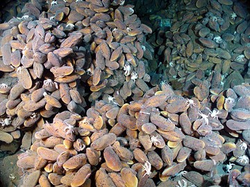
At NW Eifuku volcano, mussels are so dense in some places that they obscure the bottom.The mussels are ~18 cm long. The white galatheid crabs are ~6 cm long.A tremendous mussel biomass adorned the lava ridges at the crest of NW Eifuku volcano.They were attached by sticky threads (known as byssal threads) spun by each animal''s foot.Other than being much larger -- these deep-sea mussels were up to 18 cm (7 in) long -- they were very similar to their intertidal cousins. Mussels are found at hydrothermal vents and cold seeps around the world. They are part of the genus Bathymodiolus,first discovered at hot vents off western Mexico. While their presence here was not a big surprise, their density and the relative lack of other fauna were intriguing. Unlike elsewhere, these mussels were not residing in cracks or clustered around flowing vent water. Instead, they were clustered on the tops of rocks. The Champagne smokers were located downslope from the mussels,but there was no temperature anomaly in the water around the mussels http://www.vulkaner.no/v/volcan/submarin/mariana-arc.html |
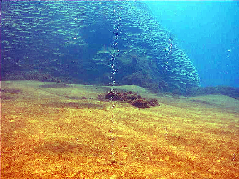
Bubbles from seafloor in Maug crater with rich corals in background – MARAMP 2007. No eruptions are known from Maug since its discovery in 1522. However, hydrothermal activity has been detected by NOAA cruises in the past several years- http://www.soest.hawaii.edu/pibhmc/pibhmc_cnmi.htm |
Maug http://coolsciencenews.blogspot.com/2009_10_11_archive.html |
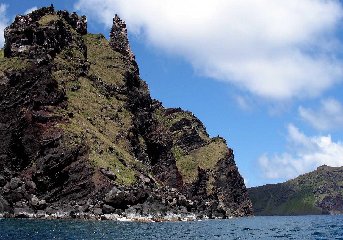
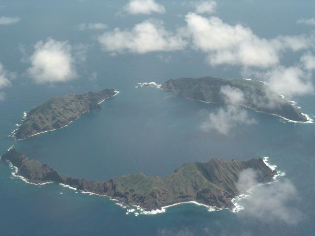
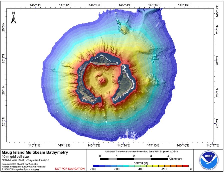
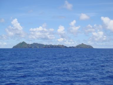
Maug. Three small elongated islands (stratovolcano, fumarolic) up to 2.3 km long mark the northern, western, and eastern rims of a largely submerged 2.5-km-wide caldera. The highest point of the Maug Islands reach only 227 m above sea level; the submerged southern notch on the caldera rim lies about 140 m below sea level. The caldera has an average submarine depth of about 200 m and contains a twin-peaked central lava dome that rises to within about 20 m of the sea surface. The Maug Islands form a twin volcanic massif with Supply Reef, about 11 km to the north. The truncated inner walls of the caldera on all three islands expose lava flows and pyroclastic deposits that are cut by radial dikes; bedded ash deposits overlie the outer flanks of the islands. No eruptions are known since the discovery of the islands by Espinosa in 1522. The presence of poorly developed coral reefs and coral on the central lava dome suggests a long period of general quiescence, although it does not exclude mild eruptions (Corwin, 1971). A recent NOAA expedition detected possible evidence of submarine geothermal activityhttp://www.volcano.si.edu/world/volcano.cfm?vnum=0804-143 |
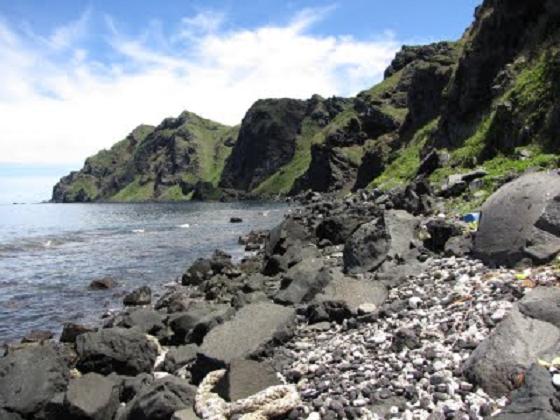
Maug Lagoon. The three small islands are the rim of the submerged summit crater of Maug volcano. The volcano is made of pyroclastic rocks and thin layers of tholeiitic basalt. Submarine domes on the crater floor are the youngest features at Maug. The inner wall of East Island shows a vertical dike seen slicing up through thin volcanic flows. The three islands are the remains of a partly submerged volcano that surrounds a deep and spacious natural harbor. Steep cliffs border the islands. On the north and west islands there are columns resembling tombstones which crown the ridges, (out crops of basaltic veins). Uninhabited since 1695.Ecosystems: scrub and grasses, coconuts on East Island; rocky shore and Lagoon with algal mat scattered corals; fringing reef off West Island. Special features: seabird rookery; proposed as marine sanctuary.Plants: 59 species including several group endemics but no island endemics Lysimachia mauritiana.Birds: 11 seabirds, 2 shore birds, 3 land birds: Megapodius laperouse laperouse (Marianas Megapode) group endemic subspecies, Rare (RDB) Aplonis opacus aeneus (Micronesian starling) subspecies endemic to northernmost Mariana Islands Halycon chloris owstoni (white-collard Kingfisher) subspecies endemic to the northernmost Mariana Islands.Mammals: Pteropus mariannus (Marianas fruit bat) group endemic.Marine life: 232 fish species, 130 invertebrate species including 24 opisthobranchs, 60 algae http://www.guam.net/pub/sshs/depart/science/mancuso/marianas/maug/maug.htm |
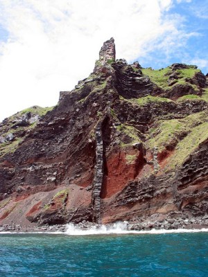
The vertical column in the center of the image, called a dike, rises from below sea level to the pinnacle at the top of the ridge. Interlaid massive lavas (darker horizontal bands) and ash-rich lava units (reddish) are also exposed on the islets of Maug http://www.vulkaner.no/v/volcan/submarin/mariana-arc.html |
Maug-The three steep islands are vegetated mostly by low scrub, grass and a few palm trees- http://www.soest.hawaii.edu/pibhmc/pibhmc_cnmi.htm |
Maug |
Maug, h=227m, is actually three islands that were once part of the rim of a volcano now partially submerged. Where the volcano cone was is now a deep and spacious natural harbor. Steep cliffs border the islands and the landscape on the north and west islands is dominated by columns of basalt resembling tombstones. Highest point North Island, 227 m. Size: 2 square km -http://media.marine-geo.org/image/ibm-volcano-maug-2004 An aerial view of the Maug Islands from the NE shows Kita-shima (North Island) at the right margin, Higashi-shima (East Island) in the foreground, and Nishi-shima (West Island) in the background.The islands enclose a 2.5-km-wide submarine caldera that contains a submerged lava dome that rises to within about 20 m of the sea surface. No eruptions are known from the Maug Islands since their discovery by Espinosa in 1522. The Maug Islets consists of three small elongated islands up to 2.3 km long mark the northern, western,and eastern rims of a largely submerged 2.5-km-wide caldera. The highest point of the Maug Islands reach only 227 m above sea level; the submerged southern notch on the caldera rim lies about 140 m below sea level http://www.vulkaner.no/v/volcan/submarin/mariana-arc.html |
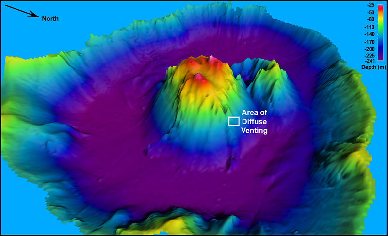
Maug caldera Maug caldera, ranging in depth from 241 to 25 m http://www.vulkaner.no/v/volcan/submarin/mariana-arc.html http://en.wikipedia.org/wiki/Maug_Islands, http://en.wikipedia.org/wiki/File:Maug_caldera_bathymetry.jpg |
http://www.soest.hawaii.edu/pibhmc/pibhmc_cnmi_mau_bathy.htm |
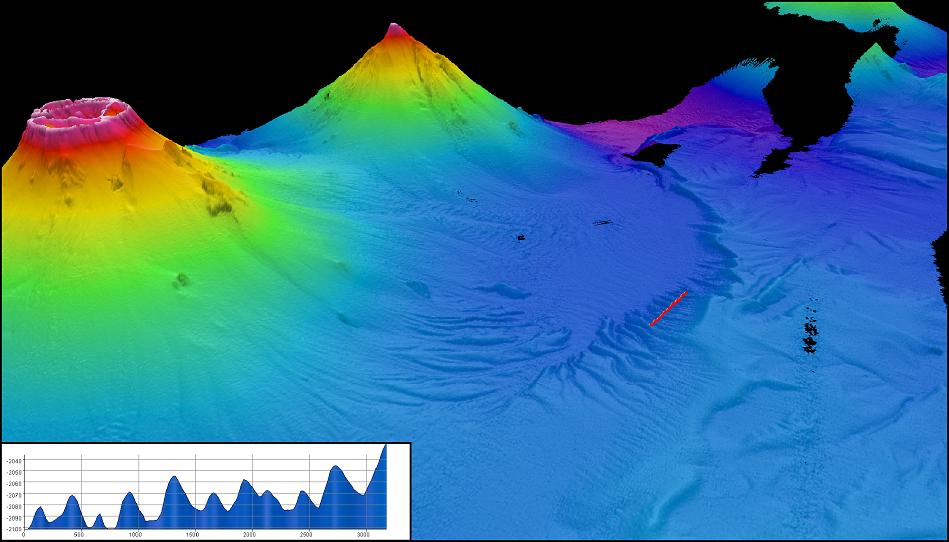
Channels on the northeastern flank of Maug. Supply Reef is in the background. Multibeam sonar data were collected in and around Maug in 2007 in water depths down to 2000 m on all sides and to 3000 m in some places. The multibeam data show a peak with depths as shallow as 22 m in the center of the caldera and over 225 m deep on the caldera floor. The deeper multibeam data surrounding the island are some of the most interesting data collected during MARAMP 2007. The perspective view shown here highlights the region between and to the east of Maug and Supply Reef where channels on the volcanoes flanks terminate in a narrow basin. The eastern boundary of the basin is a sinuous ridge also incised by channels and canyons originating at the ridge crest. The SW-NE profile above gives a sense of the size of these features.http://www.soest.hawaii.edu/pibhmc/pibhmc_cnmi.htm |
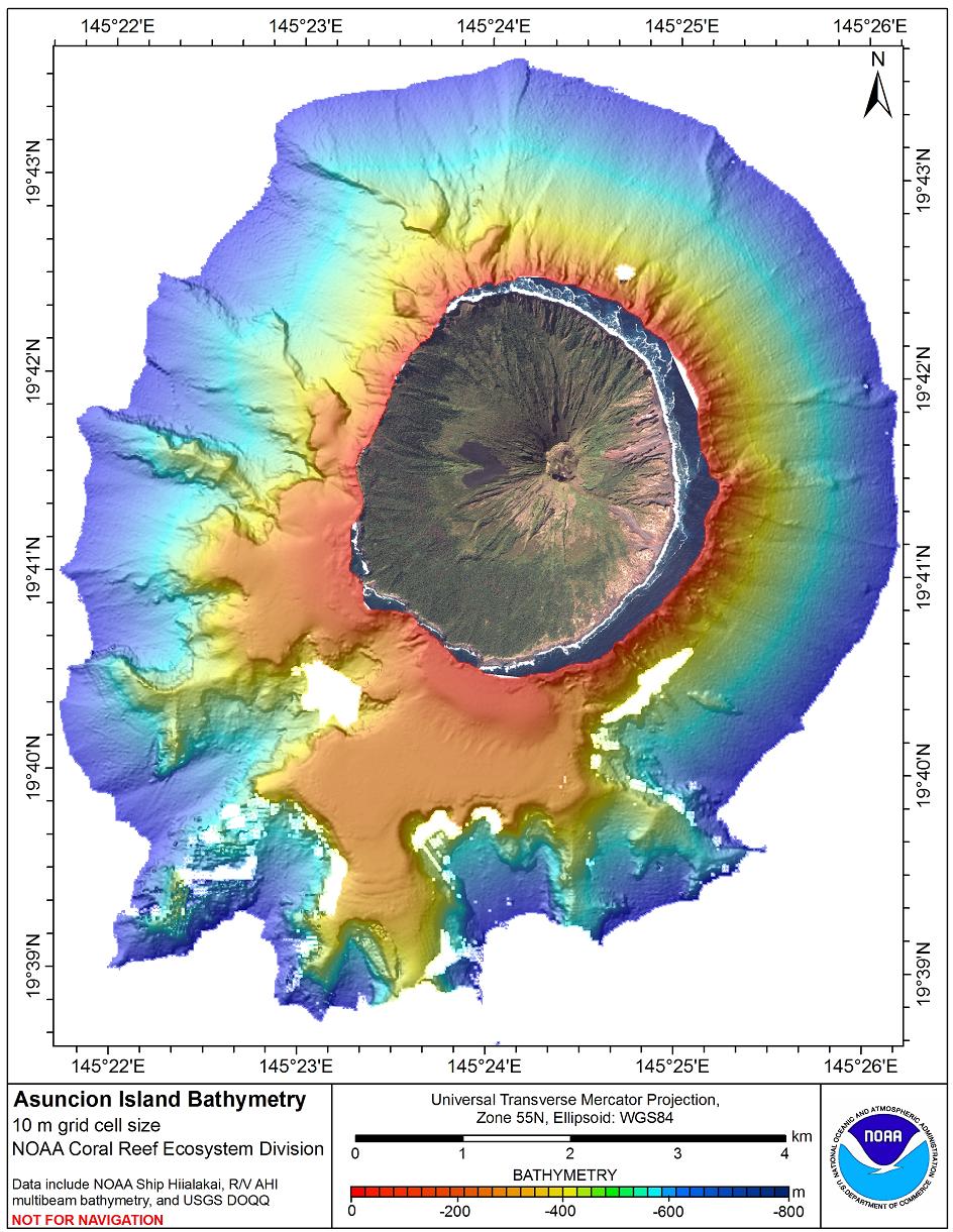
Asuncion http://www.soest.hawaii.edu/pibhmc/pibhmc_cnmi_asu.htm |
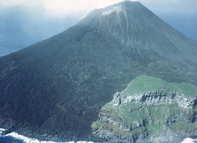
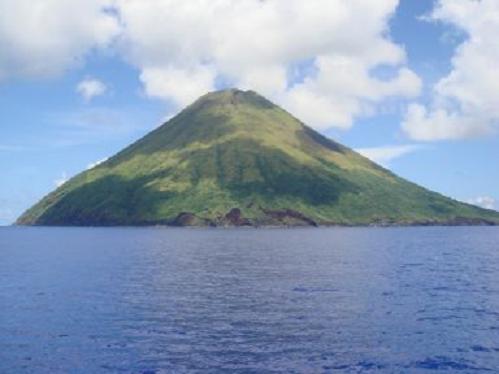
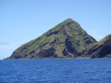
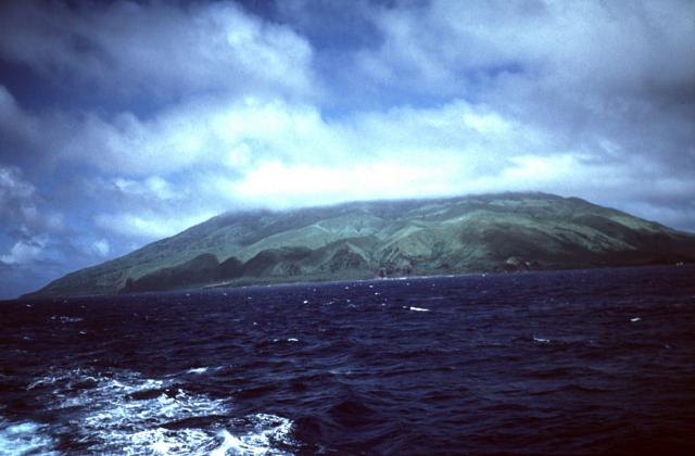
A single large asymmetrical stratovolcano, 857 m, steeper on the NE side, forms 3-km-wide Asuncion Island. The steep NE flank of the 857-m-high volcano terminates in high sea cliffs. The gentler SW flanks have low-angle slopes bounded by sea cliffs only a few meters high. The southern flank of the volcano is cut by a large landslide scar. The southern flanks and western flanks of the volcano are mantled by ash deposits that may have originated during eruptions in historical time, 1906. An explosive eruption in 1906 also produced lava flows that descended about half way down the western and SE flanks, but several other historical eruption reports are of uncertain validity http://www.volcano.si.edu/world/volcano.cfm?vnum=0804-15= |
Asuncion''s peak. Asuncion is a stratovolcano. The most recent confirmed eruption was in 1906. Volcanologist visited Asuncion in 1992 and observed active fumaroles. A view of the west flank of Asuncion clearly shows the rocky shore, palm-covered slopes and the summit cloaked in clouds. The volcano rises steeply as an almost perfect cone. White smoke occasionally emerges from the top and slopes. Lava has steamed down the mountainsides giving it a black surface. Shrubs and a few trees can be seen in some places. There is a landing beach at the southwest end of the island. Asuncion is uninhabited.Human impact: coconut plantations on lower slopes, visited ccasionally.Ecosystems: rain forest in ravines, grasslands and fernlands on upper Slopes.Special features: active volcano; best forest development in northern islands, of considerable conservation interest; proposed as marine sanctuary.Plants: New endemic tree.Birds: Megapodius laperouse laperouse (Marianas Megapode) group endemic subspecies, Rare (RDB), locally not threatened by introduced predators - http://www.guam.net/pub/sshs/depart/science/mancuso/marianas/asuncion/asuncion.htm |
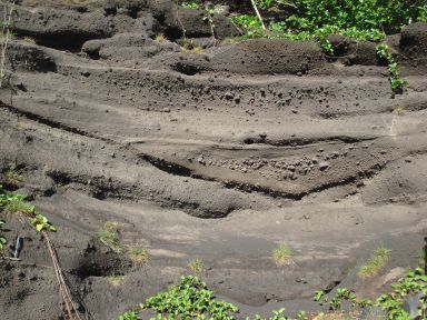
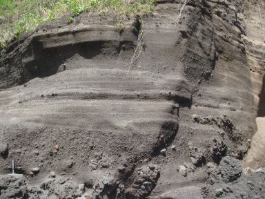
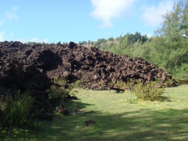
Mafic pyroclastic density current deposits (Asuncion)-http://www.eri.u-tokyo.ac.jp/fmaeno/PHOTOS/mariana2.html |
|
Marg http://www.eri.u-tokyo.ac.jp/fmaeno/PHOTOS/mariana2.html |
Collapsed edifice (Marg) http://www.eri.u-tokyo.ac.jp/fmaeno/PHOTOS/mariana2.html |
Collapsed edifice (Marg) http://www.eri.u-tokyo.ac.jp/fmaeno/PHOTOS/mariana2.html |
Northern Marianas (North) |
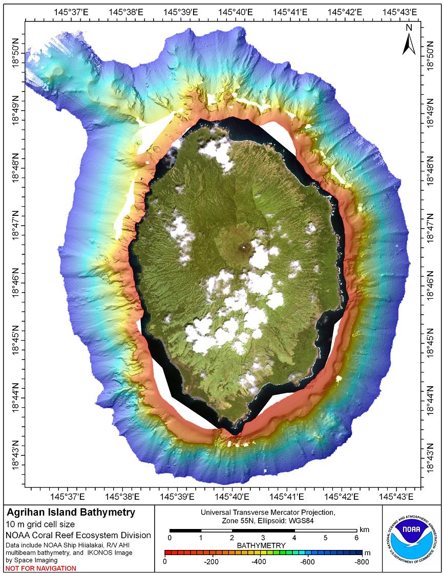
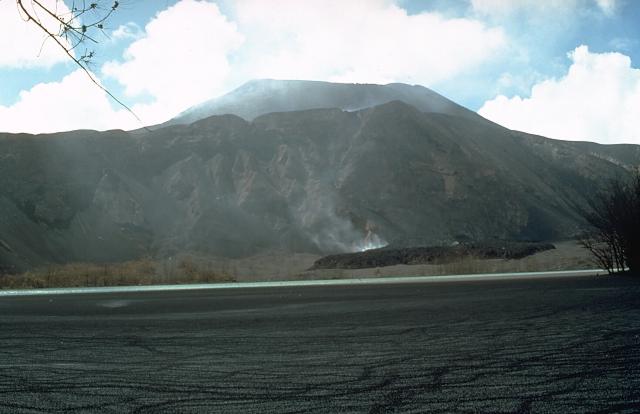
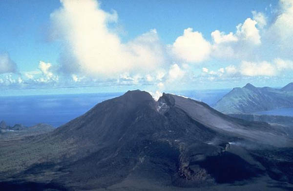
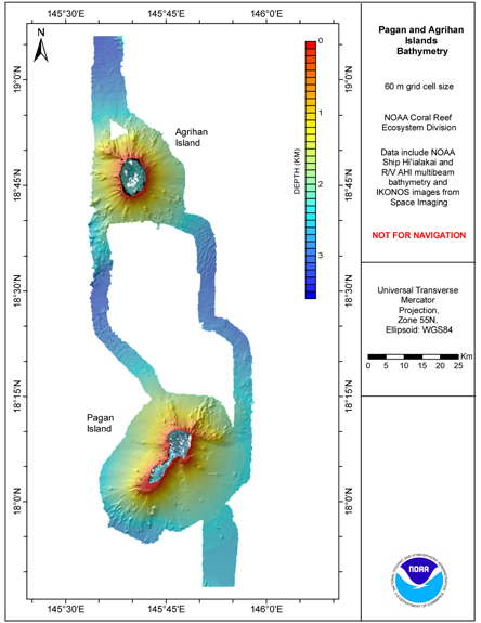
Agrihan stratovolcano, http://en.wikipedia.org/wiki/Agrihan http://volcanoes.einnews.com/news/agrihan-volcano |
The highest of the Marianas arc volcanoes, 965m, historical 1917 eruption, Agrigan contains a 500-m-deep, flat-floored caldera. The elliptical island is 8 km long; its 965-m-high summit is the top of a massive 4000-m-high submarine volcano, the second largest in the Marianas Islands. Deep radial valley dissect the flanks of the thickly vegetated stratovolcano. The elongated caldera is 1 x 2 km wide and is breached to the NW, from where a prominent lava flow extends to the coast and forms a lava delta. The caldera floor is surfaced by fresh-looking lava flows and also contains two cones that may have formed during the volcano''s only historical eruption in 1917. This eruption deposited large blocks and 3 m of ash and lapilli on a village on the SE coast, prompting its evacuation -http://www.volcano.si.edu/world/volcano.cfm?vnum=0804-16%3D |
Mafic pyroclastic density current deposits (Agrihan) - http://www.eri.u-tokyo.ac.jp/fmaeno/PHOTOS/mariana2.html |
Agrihan lava flow |
Agrihan, The massive coconut crab. Agrigan is a stratovolcano with a small caldera at its summit. Island type: high volcanic cone, radially dissected.The volcano forms an island about 7 km in diameter. Agrigan is made of basalt and lesser amounts of andesite. A single known historic eruption in 1917 threw blocks up to about 1-m in diameter as far as 5-km from the vent. About 3-m of ash fell on a coastal village. Deformation measurements made on Agrigan in 1992 revealed no significant changes since the volcano was first measured in 1990. In August of 1990, an increase in fumarole activity was observed on the cone within the caldera. No earthquakes were felt . The island''s nine residents were evacuated. No eruption occurred. The southwest and west flank of Agrigan shows deeply dissected slopes. The lower slopes are covered with palm trees, and the upper slopes are covered with swordgrass, making this area unpassable. This volcano has gentle slopes near the shore on the southeast and southwest sides with the crater entrance on the north side. The remainder of the island consists of steep slopes and deep gorges. The coast is rocky and steep with a landing beach only on the southwest coast.Human impact: small resident population; coconuts, lower slopes cultivated.Ecosystems: rain forest in ravines, Miscanthus grasslands on upper slopes. Special features: dormant volcano; forest of conservation interest, summit unexplored botanically. Birds : Megapodius laperouse laperouse (Marianas Megapode) group endemic subspecies, Rare (RDB); Gallinula chloropus guami (Marianas Gallinule or Common Moorhen) group endemic subspecies, Pagan, Saipan, Tinian, Guam, Rare (RDB), local status unknown.http://www.guam.net/pub/sshs/depart/science/mancuso/marianas/agrigan/agrihan.htm |
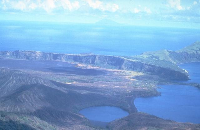
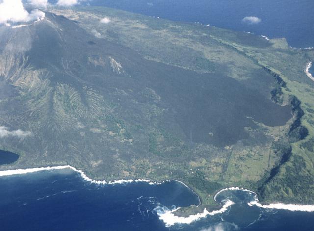
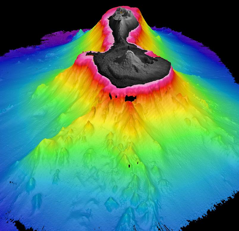
This south-looking view across the isthmus of Pagan Island shows Alamagan Island in the distance. The arcuate wall cutting across the center of the photo is the southern rim of a 7-km-wide caldera inside which North Pagan volcano was constructed. The lake in the foreground is the westernmost of two maars that cut the western flank of North Pagan. The black lava flow on the caldera floor at the left center in this June 16, 1981 photo was erupted from a vent on the south rim of North Pagan volcano beginning on May 15, 1981. Photo by U.S. Navy, 1981.http://www.volcano.si.edu/world/volcano.cfm?vnum=0804-17= |
An aerial view of Pagan volcano from the west in August 1981 shows dark lava flows from the May 1981 eruption that descended the south flank as far as the arcuate caldera wall. The flows originated from a vent along a notch on the south rim of the summit crater of North Pagan volcano early in an eruption that began on May 15. This was the southernmost of three vents that were active during the 1981 eruption.Photo by U.S. Navy, 1981.http://www.volcano.si.edu/world/volcano.cfm?vnum=0804-17= |
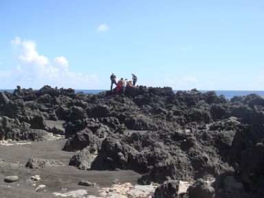
1981 (Pagan). The SW-flank lava flow from the May 1981 eruption. The SW-flank flow traveled 3 km from its vent on the south crater rim. Other flows traveled down the north flank almost to the coast. http://www.eri.u-tokyo.ac.jp/fmaeno/PHOTOS/mariana2.html |
A black, steaming lava flow advances across the floor of a maar on the west flank of North Pagan volcano on May 23, 1981. The flow originated from the summit crater of North Pagan (background) on May 15. Most of the foreground surface of a lagoon on the floor of the maar is covered by black, floating pumice from the powerful explosive eruptions of the 15th. Photo by Norm Banks, 1981 (U.S. Geological Survey).http://www.volcano.si.edu/world/volcano.cfm?vnum=0804-17= |
Two maars cut the western flank of North Pagan volcano. Pyroclastic-surge deposits from the latest eruption of the 1.5-km-wide eastern maar, seen here from the NE with South Pagan volcano in the distance, were adiocarbon dated at about 150 years ago. This May 24, 1981 photo shows a steaming lava flow on the floor of the maar. It originated from the summit crater of North Pagan volcano during an eruption that began on May 15.Photo by Norm Banks, 1981 (U.S. Geological Surveyhttp://www.volcano.si.edu/world/volcano.cfm?vnum=0804-17= |
A prominent eruptive fissure cuts across the summit of North Pagan volcano on May 15, 1981, on the opening day of the 1981 eruption. It is seen here on May 26, 1981, looking across a north-flank cinder cone that formed along the fissure during the 1981 eruption. The foreground trees are from a devastated coconut plantation.Photo by Norm Banks, 1981 (U.S. Geological Survey).http://www.volcano.si.edu/world/volcano.cfm?vnum=0804-17= |
Pogan - Giant hole emitting sulfurous gashttp://sio.ucsd.edu/marianas/journal/0424/ |
Mount Pagan http://sio.ucsd.edu/marianas/journal/0424/ |
A fissure that formed during an eruption of Pagan volcano in the Mariana Islands in 1981 cuts across the summit of the volcano. Three principal vents were active along the fissure.A cinder cone (foreground) was constructed on the north flank, and vents on the north and south rims of the summit crater fed lava flows that traveled down the flanks of North Pagan volcano. This June 16, 1981 photo shows South Pagan volcano at the upper right. PHOTO SOURCE: US Navy 1981, courtesy of the Global Volcanism Program, Smithsonian National Museum of Natural History, used with permission. http://www.geographic.org/photos/volcanoes/volcano_photos_52.html |
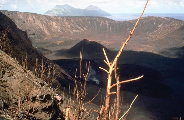
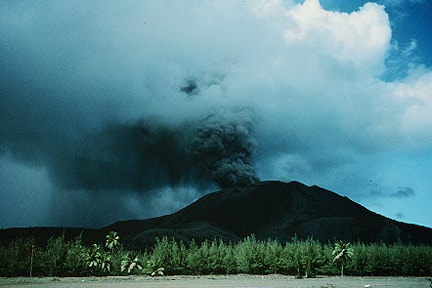
North Pagan volcano rises above the Sengan Peninsula on its SSE flank. The peninsula is eroded from rocks of a pre-North Pagan volcano that was truncated by a 7-km-wide caldera.North Pagan volcano, the most active of two volcanoes on Pagan Island, was constructed within the past 3000 years. Photo by U.S. Navy, 1982Pagan Island, the largest and one of the most active of the Mariana Islands volcanoes, consists of two stratovolcanoes connected by a narrow isthmus. Both North and South Pagan stratovolcanoes were constructed within calderas, 7 and 4 km in diameter, respectively. The 570-m-high Mount Pagan at the NE end of the island rises above the flat floor of the northern caldera, which may have formed less than 1000 years ago.South Pagan is a 548-m-high stratovolcano with an elongated summit containing four distinct craters.Almost all of the historical eruptions of Pagan, which date back to the 17th century, have originated fromNorth Pagan volcano. The largest eruption of Pagan during historical time took place in 1981 and prompted theevacuation of the sparsely populated island. December 12th, 2011During 4-5 December, residents 3 km SW of Pagan reported ashfall that accumulated in their camp at a rateof about 6.4 mm per day. They also described a plume from the summit that rose to an altitude of 640 m(2,100 ft) a.s.l. and a sulfur smell that occasionally wafted through their camp. Based on satellite imagery, the Washington VAAC reported a gas-and-ash plume that drifted mainly W on 5, 6, and 8 December. Satellite imagery showed no further activity through 11 December.April 1981Large tephra cloud; lava flows; 53 evacuatedA strong explosive eruption from North Pagan began on 15 May. While reporting strong felt seismicity on the island, radio operator Pedro Castro suddenly announced at 0915 that the volcano was erupting. Communication was thencut off. An infrared image from the GMS at 1000 showed a very bright circular cloud about 80 km in diameter over the volcano. The cloud spread SE at about 70 km/hour, and by 1600 its maximum height was estimated at13.5 km from satellite imagery. North Pagan volcano rises above the Sengan Peninsula on its SSE flank. The peninsula is eroded from rocks of a pre-North Pagan volcano that was truncated by a 7-km-wide caldera. North Pagan volcano, the most active of two volcanoes on Pagan Island, was constructed within the past 3000 years.Photo by U.S. Navy, 1982.http://www.volcano.si.edu/world/volcano.cfm?vnum=0804-17=, http://www.vulkaner.no/v/volcan/pacific/pagan.html |
Pagan 1994.Pagan Iiland type: cluster of volcanoes, linked by lava and ash. The island has three volcanoes, one of the northern ones is which is active and separated from the other volcano in the south. The active North volcano emits steam and is frequently veiled by a heavy, sulphurous cloud. The slopes of Mt. Pagan are covered by brown ash and at the base of the mountain, there are two curious lakes. A series o f vertical cliffs cut the island in two. The coast is rocky and unapproachable except on the shores of Eastern Roadstead and Apaan Bay on the west coast. The largest eruptions was at North Pagan in 1981. The height of the eruption column was 18-20 km. Lava flowed down the northeast, northwest, and southwest flanks of the volcano. Fifty-three residents were evacuated without serious injury. Subsequent eruptions in 1987, 1988, 1992, and 1993 were less explosive. Minor ash eruptions occurred at Pagan in March of 1983. Ashfall was limited to the summit cone. Earthquake activity began to increase beneath Pagan in late 1992. In January of 1993, a magnitude 5.7 earthquake occurred deep beneath the volcano. Several eruptions occurred early in the year, sending columns of ash over a 2-km above the summit of North Pagan stratovolcano. Bursts of tremor continued during the first half of 1993, indicating intermittent ash eruptions. Minor volcanic activity continued during the remainder of the year. A typical eruption at Pagan followed a set series of events. Activity started with earthquake tremor. A few minutes later gases were emitted. About a minute later ash was erupted. After about 5 minutes, the ash plume reached a height of 2 km .Human impact: small population, some cultivation.Ecosystems: light forest and scrub. Grasslands, swamp.Special features: active volcanoes with eruption continuing since 1981; freshwater lake with hot sulfur springs, brackish lake; some forest of conservation interest; proposed as marine sanctuary.Birds: Megapodius laperouse laperouse (Marianas Megapode) group endemic subspecies, Rare (RDB); Gallinula chloropus guami (Marianas Gallinule or Common Moorhen) group endemic subspecies, Rare (RDB).http://www.guam.net/pub/sshs/depart/science/mancuso/marianas/pagan/pagan.htm |
A volcano on Pagan, 2010, one of the Mariana Islands. Volcanic activity near subduction zones around the world is fueled in part by water in the mantle.http://www.ouramazingplanet.com/2658-mariana-trench-expedition-peers-deep-earth.html Pagan volcano consists of 2 stratovolcanoes (North and South Pagan) connected by a narrow isthmus and forms the largest and one of the most active of the Mariana Islands. It is located 173 nautical miles north of Saipan. Nearly all historical eruptions of Pagan, which were recorded since the 17th century, were from North Pagan volcano. The largest historic eruption was in 1981 and prompted the evacuation of the sparsely populated island. Background:Both North and South Pagan stratovolcanoes were constructed within calderas, 7 and 4 km in diameter, respectively. The 570-m-high Mount Pagan at the NE end of the island rises above the flat floor of the northern caldera, which may have formed less than 1000 years ago. South Pagan is a 548-m-high stratovolcano with an elongated summit containing 4 distinct craters. (from: Smithsonian / GVP) 2011 activity Small ash emissions were reported from Pagan volcano at the end of August 2011.2010 eruptions An ash eruption was reported from Pagan on 6 May 2010.2009 ash eruptions Activity was noted in April and August 2009. "Black ash" and steam were observed on 16 April 2009. Crew aboard a NOAA research ship observed continuous emissions from the N crater during 21-22 April. A small ash eruption probably occurred at Pagan volcano on 15 Aug 2009, as an ash plume drifting NW and a hot spot were observed by satellite.2006-07 activity In December 2006 ash eruptions occurred at Pagan volcano and continued into January. Up to a cm per day of ash were reported accumulating 3 km SW of the summit. ...1993 eruptionsIntermittent ash eruptions occurred at Pago volcano from January to March 1993. Frequent ash eruptions produced plumes reaching 1-2 km height. http://www.volcanodiscovery.com/pagan.html |
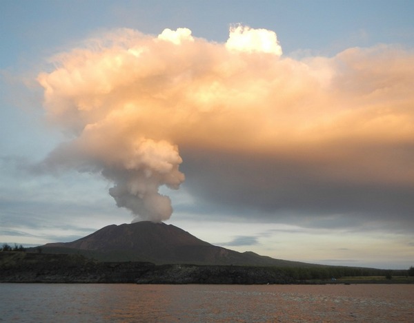
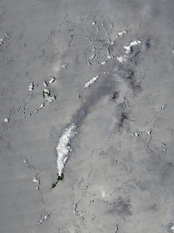
The Moderate Resolution Imaging Spectroradiometer (MODIS) aboard the Aqua satellite caught the volcanic emissions on the morning of September 2, 2012 (Credit: Jeff Schmaltz MODIS Land Rapid Response Team, NASA GSFC)http://thewatchers.adorraeli.com/2012/09/14/satellite-image-of-eruption-on-pagan-island-mariana-islands/ |
A plume of steam poured from the restless Pagan volcano in early September 2012. A gray plume of volcanic steam and gas rises from the Pagan volcano and streams northward over the Pacific Ocean was observed by MODIS satellite on September 2. http://thewatchers.adorraeli.com/2012/09/14/satellite-image-of-eruption-on-pagan-island-mariana-islands/ |
Pagan Island, 570m, the largest and one of the most active of the Mariana Islands volcanoes, consists of two stratovolcanoes connected by a narrow isthmus. Both North and South Pagan stratovolcanoes were constructed within calderas, 7 and 4 km in diameter, respectively. The 570-m-high Mount Pagan at the NE end of the island rises above the flat floor of the northern caldera, which may have formed less than 1000 years ago. South Pagan is a 548-m-high stratovolcano with an elongated summit containing four distinct craters. Almost all of the historical eruptions of Pagan, which date back to the 17th century, have originated from North Pagan volcano. The largest eruption of Pagan during historical time took place in 1981 and prompted the evacuation of the sparsely populated island.South Pagan volcano occupies the SW end of Pagan Island. The ridge in the right foreground is the eroded rim of a 4-km-wide caldera inside which the conical South Pagan volcano (left) was constructed. The elongated summit of South Pagan is cut by four craters. Eruptions of South Pagan volcano occurred during the 19th century, but it has been much less active than North Pagan volcano http://www.volcano.si.edu/world/volcano.cfm?vnum=0804-17= http://www.soest.hawaii.edu/pibhmc/pibhmc_cnmi.htm |
http://www.volcano.si.edu/world/volcano.cfm?vnum=0804-17=&volpage=var |
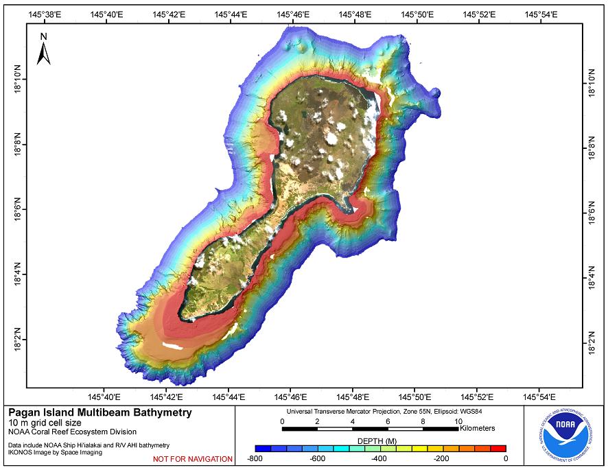
Pagan -http://www.soest.hawaii.edu/pibhmc/pibhmc_cnmi_pag.htm |
Northern Marianas (Central) |
Northern Marianas (South) |
Northern Marianas (Transit) |
Southern Marianas |
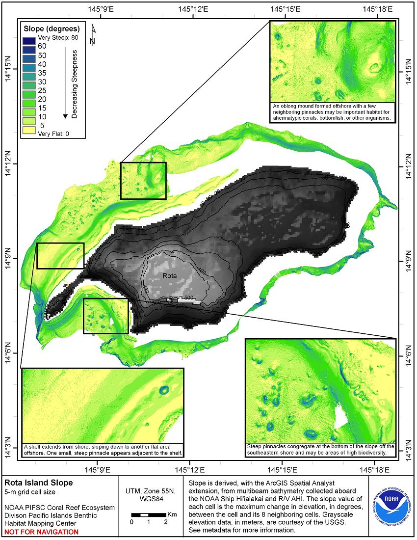
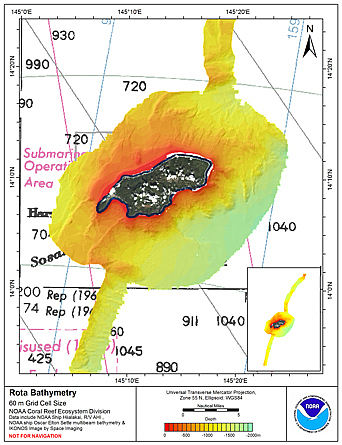
Rota Island |
Rota. |
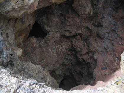
NW Rota. The volcano rises to a height of 535 meters below sea level. Its base is over 2000 meters deep. Giant smoky plume discovered pouring out of "Brimstone Pit" crater near the summit of NW Rota 1 volcano.The first site found (above the pit) was a large area of sand with shimmering water percolating through it.Inserting a temperature probe in it yielded a temperature of over 100 C! A huge amount of heat and highly acidic fluid is coming out of this large area of sand.Brimstone Pit, which clearly has two side-by-side eruptive vents, is near the summit of the volcano at 555 meters depth, almost engulfs the vehicle in an ash plume. Chemical analysis of the plumes showed that they were among the most unusual ever found above a hydrothermal source.The particles suspended in the plumes contained the highest concentration of particulate aluminum ever recorded,in addition to high concentrations of sulfur, iron, and manganese. See movie at -http://www.vulkaner.no/v/volcan/submarin/mariana-arc.html |
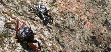
Unusual spiny crab spotted on NW Rota 1 volcano. Crabs are opportunistic predators at vent sites.The body of this crab is ~2 in. (~5 cm) across. The unusual chemistry here indicates that at least some of the vents on NW Rota #1 are rich in sulfuric acid.Sulfur is a rich energy source for the microbes that live in hydrothermal systems. All other life in the hydrothermal ecosystems depend on these microbes -http://www.vulkaner.no/v/volcan/submarin/mariana-arc.html |
This is a small, ice-cream-cone-shaped chimney located near the base of Five Towers,which shows the affects of hydrothermal fluid boiling on the sea floor.There are at least 50 chimneys in the area named the “Black Forest." Most of the chimneys seen were dead; that is, hot water had ceased to flow within them. Most were around 2 m tall but some stretched up to 9 moff the sea floor. Moving upslope amongst the chimneys, the expedition discovered that some were verymuch alive. One group, aptly named “Five Towers," had a large base several meters in diameter with individual chimneys 7-9 m high that spewed black smoke into the surrounding seawater.The expedition have never seen a field of chimneys like this in such shallow water. Finally, they witnessed a rarely seen phenomenon. They saw evidence of hot water boiling right at the exit point of one of these chimneys, where streams of bubbles (gas) emanated from one part of the chimney while hot liquid escaped from a different part http://www.vulkaner.no/v/volcan/submarin/mariana-arc.html |
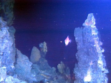
Aa shallow-water tropical fish swimming among active black smoker chimneys at Black Forest vent field. The chimneys rise up to 7 m tall. http://www.vulkaner.no/v/volcan/submarin/mariana-arc.html |
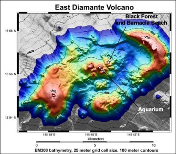
Active “smoker” chimneys precipitating iron, copper and zinc sulfides from 230oC fluid. They are 9 m tall from the base to the top of the chimneys. Dark beehive-type chimneys, here about 30 cm tall, commonly sit on top of these structures. After reaching the sea floor at East Diamante, low-temperature diffuse venting was quickly recognized amidst the boulder-strewn slope. The presence of barnacles (possibly a new species) coined the name of the first site as “Barnacle Beach." After a short search around the rim of the cone, the expedition came across a line of sulfide chimneys (named the “Black Forest”) upslope of Barnacle Beach. http://www.vulkaner.no/v/volcan/submarin/mariana-arc.html |
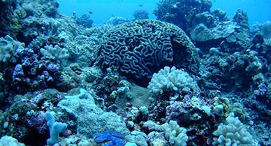
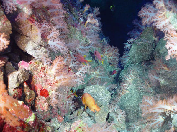
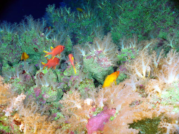
This stunning image of Aquarium site shows the picturesque gully with its abundant sea life,which includes algae (red and green), soft corals (pink with white stalks) and tropical fishes http://www.vulkaner.no/v/volcan/submarin/mariana-arc.html |
On the summit of East Diamante (170 m), all signs of hydrothermal venting have disappeared.Soft corals (~10-15 cm tall) and tropical fish share the paradise named “Aquarium http://www.vulkaner.no/v/volcan/submarin/mariana-arc.html |
http://www.vulkaner.no/v/volcan/submarin/mariana-arc.html see fol location http://plate-tectonic.narod.ru/mariana4photoalbum.html |
Guam see http://plate-tectonic.narod.ru/mariana5photoalbum.html |
|
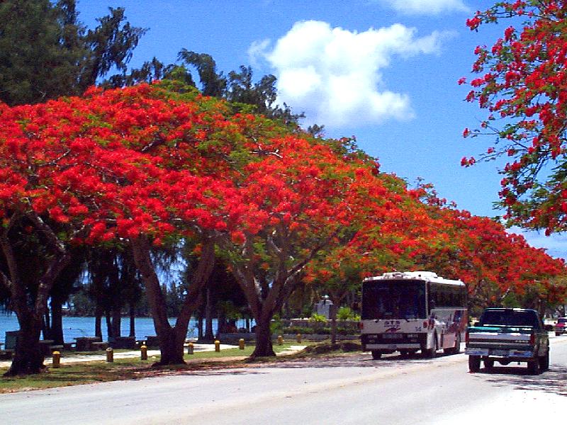
Flame trees |
|
Nerium |
Pink oleander |
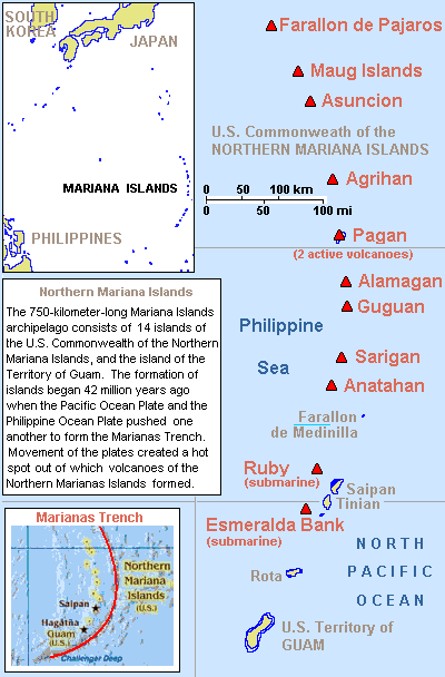


Северные Mарианские острова
Источник: http://www.zoodrug.ru/topic3234.html. Тектоническое развитие Марианской дуги началось в раннем миоцене. Однако новейшая активизация, образование глубоководных желобов и бурное развитие вулканизма начались только в позднем плиоцене, когда и - сформировались андезитовые вулканические массивы, насаженные на миоценовое основание о-вов. Позднее—в плейстоцене и голоцене— вулканизм проявился слабее и локализовался на отдельных о-вах. Голоценовый и современный вулканизм проявился главным образом во внутренней зоне фронтальной дуги —на Северных Марианских о-вах, где и сформировались большие влк.
Уракас (360 м) — на северной оконечности Северных Марианских о-вов. 20°32 с.ш., 144°54 в.д. Стратовулкан, дм. 1500 м. Усеченный конус, ни вершине древний кратер, стенки которого сложены авгит-гиперстеномыми андезитами. Активен, извержения имеют стромболианский характер.
Фаральон-де-Пахарос (310 м) — на северном фланге Марианской дуги, образует северное звено группы Фаральон-де-Пахарос—Мауг — Асунсьон. 20°30 с.ш., 145°00 в.д. Сложный стратовулкан правильной конической формы образует о-в; авгитовые андезиты. Активен.
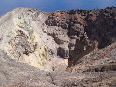
Асунсьон (891 м) — на южном окончании группы о-вов Фаральон-де-Пахарос—Мауг—Асунсьон. 19° 40 с. ш., 145° 24 в. д. Стратовулкан образует о-в дл. 4 км и шир. 3 км. Конус асимметричной формы; авгит-гиперстеновые андезиты. На вершине кратер дм. 150 м.
Агрихан (965 м)—в северной части Марианских о-вов. 18°45 с.ш., 145° 40 в. д. Вулканический о-в Агрихан дм. 8 км с площадью в 32 кв. км образован сложным стратовулканом, который поднимается над дном моря на 4 км. Лавы и пирокласты оливиновых базальтов. На вершине кратер дм. 2 км и 1 км.
Северный Паган и Южный Паган —на о-ве Паган, в средней части Северных Марианских о-вов. Северный Паган (570 м)—18° 08 с.ш., 145°48 в.д. Кальдера дм. 5 км и центральный конус в ней, расположенный на вершине щитового влк. дм. 7 км. Кальдерный вал-сомма сложен афировыми оливиновыми базальтами. На вершине центрального конуса Маунт Паган—сольфатары. Сольфатарное поле имеется и в кальдере. Активен. Южный Паган, или Маунт Тогари (548 м) —18°04 с.ш., 145°43 в.д. Сложная кальдера дм. 3 км. В ней четыре крупных и много мелких вулканических конусов, слившихся в единый массив, на котором находятся два вершинных кратера. Сильно разрушен.
Аламаган (744 м)—в средней части Марианской дуги. 17°36 с.ш., 145° 50 в. д. О-в дм. 4 км, поднимающийся на 1500 м над дном моря; оливиновые базальты и их пирокласты. В верхней части конуса на выс. 700 м кратер, около которого соль-фатары.
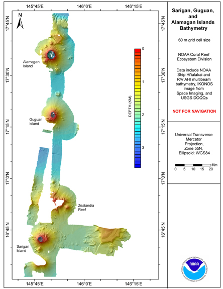
Гугуан (287 м)—в южной части группы о-вов Паган—Аламаган —Гугуан. 17° 19 с.ш., 145°51 в.д. Шлаковый конус влк. образует о-в дм. 2500 м; авгит-гиперстеновые андезиты. В северной части острова имеется молодой активный стратовулкан с кратером на вершине с большим количеством сольфатар.
Глыбовая новейшая структура Сариган-Анатахан образует южную оконечность Северных Марианских о-вов; дл. 100 км, шир. 10—15 км. Сариган (225 м) —северный в данной островной группе. 16°23 с.ш., 145° 42 в. д. Правильная коническая форма, молодой возраст; базальты. Анатахан (788 м) образует южное звено описываемой островной группы. 16°21 с.ш., 145°40 в. д. Дл. о-ва Анатахан 9 км, шир. 4 км. Он образован стратовулканом, вытянутым вдоль длинной оси о-ва. На вершине влк. кальдера эллиптической формы дм. 4 и 2 км.
Южные Mарианские острова
Источник: http://www.zoodrug.ru/topic3233.html . Это относительно крупные и более древние массивы. Сложены эоценовыми и миоценовыми вулканическими и морскими осадочными породами, в верхних частях — плиоценовыми андезитами и базальтами. Влк. на этих о-вах сохранились плохо.
Tariaxao (469 м) —в центре о-ва Сайпан. 15° 12 с.ш., 145°45 в.д. Усеченный конус. Плиоценовые авгитовые андезиты и обсидианы. Сильно разрушен. Юго-западнее о-ва Сайпан находится подводный влк. Эсмеральда-Бенкс. 15°00 с.ш., 145°20 в.д.