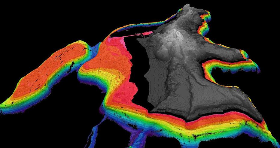
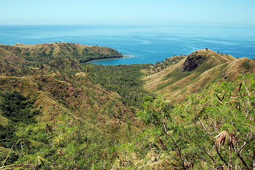
 | Central and south N.Mariana arc |
|
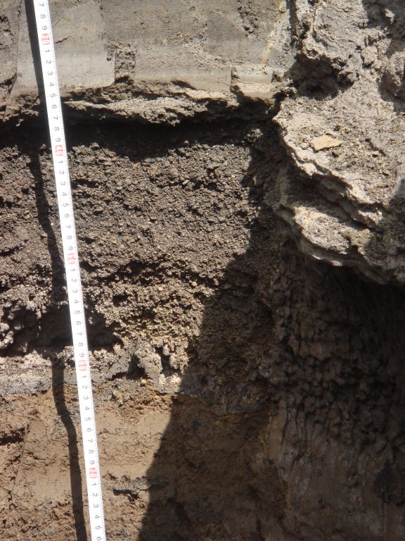
Soil formations -http://www.marianasgrazingacademy.org/PDF''s/Soils/soils_tinian_2010_notes.pdf |
|
|
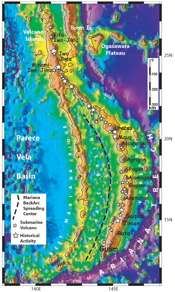
Satellite derived bathymetry, from Sandwell and Smith [1997], of the Mariana Arc region. 500 meter contour interval. Islands are labeled in black. Small white stars indicate submarine volcanoes http://oceanexplorer.noaa.gov/explorations/03fire/background/plan/media/marianas.html |
|
http://www.soest.hawaii.edu/pibhmc/pibhmc_cnmi.htm |
http://www.soest.hawaii.edu/pibhmc/pibhmc_cnmi.htm |
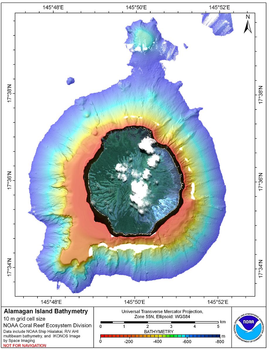
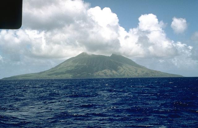
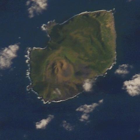
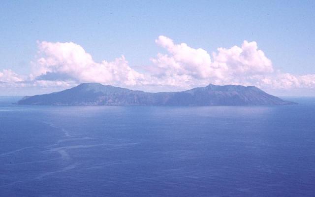
Alamagan is a stratovolcano about 30-km south of the island of Pagan. Two historic eruptions are suspected in 1864 and 1887. It is located 146 nautical miles north from Saipan and is 4.4 square miles in area. The island''s volcano has a large crater at the summit. The west side is cut by deep gorges covered with high savanna grass. The southeast side is a steep slope of bare lava. There are deep valleys with caves. Coconut palms grow on the gradual slopes. Warm fresh water springs are located on the northern part of the west coast. Ecosystems: rain forest on lava flows, grasslands on ash slopes, tree ferns on upper slopes, Special features: dormant volcano; upper slopes of conservation interest, Species of conservation interest. Plants: Cyathea alamagensis (tree fern) group? Endemic. Styphelia mariannensis only Micronesian locality.Birds: Megapodius laperouse laperouse (Marianas Megapode) group epidemic Subspecies, probably present, Rare (RDB) http://www.soest.hawaii.edu/pibhmc/pibhmc_cnmi_ala_bathy.htm |
Alamagan, stratovolcano,744m, last eruption 870AD+/-100, 540AD-+/-75, 1887?, 1864?,seen here from the west with two peaks on either side of a roughly 350-m-deep summit crater, is the emergent summit of a large stratovolcano. Low-angle lava platforms occur at the northern and southern coasts, whereas the eastern and western flanks are steeper. The exposed cone is largely Holocene in age. A 1.6 x 1 km graben cuts the SW flank. Pyroclastic-flow deposits erupted about 1000 years ago have been dated, but reports of historical eruptions were considered invalid.Photo by Norm Banks, 1981 (U.S. Geological Survey).http://www.volcano.si.edu/world/volcano.cfm?vnum=0804-18= |
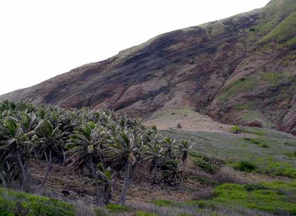
The west side of the island is cut by deep gorges covered with high savanna grass. The southeast side is a steep slope of bare lava. There are deep valleys with caves. Coconut palms grow on the gradual slopes. Warm fresh water springs are located on the northern part of the west coast -http://en.wikipedia.org/wiki/Alamagan. |
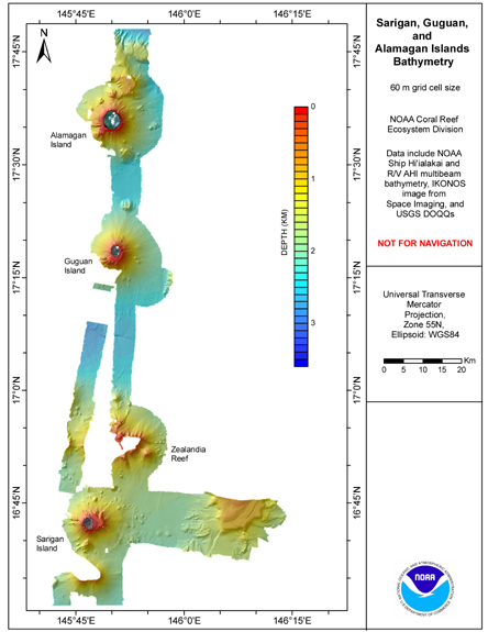
Guguan-http://www.soest.hawaii.edu/pibhmc/pibhmc_cnmi_gug_bathy.htm |
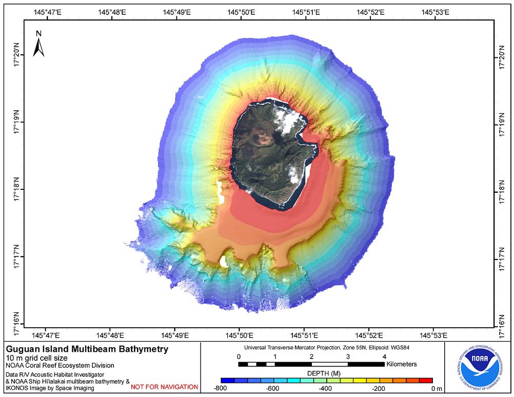
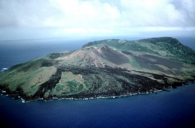
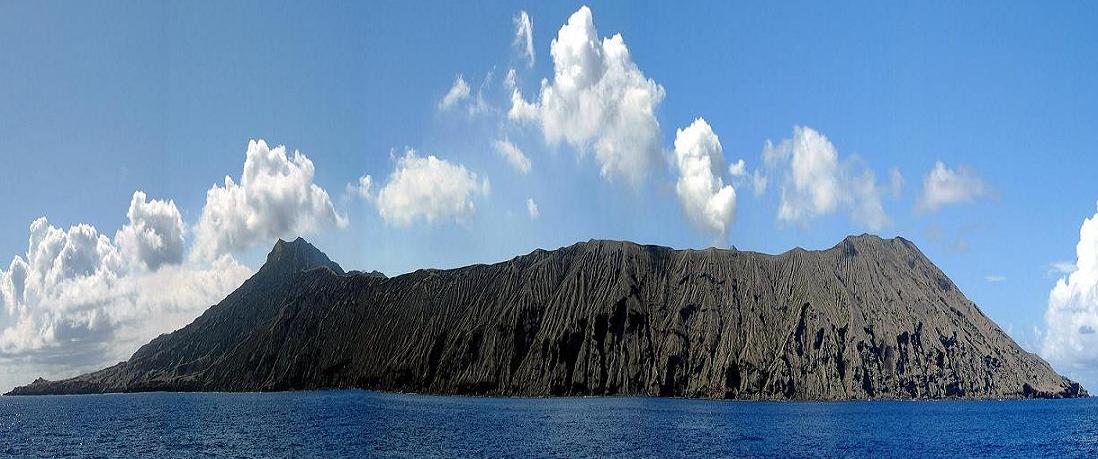
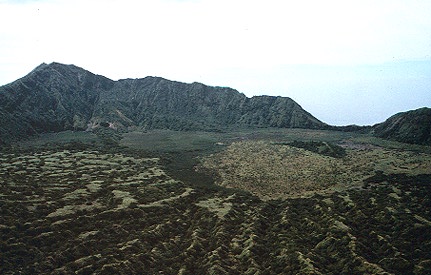
Guguan, 287-310m, 2 volcanic cones, deep ravines, and coastal cliffs. Guguan is a stratovolcano. The volcanoes of this arc are related to the subduction of the Pacific Plate beneath the Philippine Plate. A single historic eruption at Guguan in 1883 produced pyroclastic flows and lava flows. It is situated 130 nautical miles north of Saipan and is 1.5 square miles in area. The northwest wall of the active volcano has collapsed and a new cone has built up above the wall of the old one. There are deep ravines between the two peaks. Smoke and large quantities of sulfur sometimes erupt from the volcano. The sulfur has given the mountain the appearance of a snowcap from a distance. The coast is bordered by steep basaltic rock with gables of high ridges with deep, rain eroded gorges. At times a lake forms within the crater. Human impact: uninhabited, Ecosystems: northern cone bare cinders and other volcanic material, Southern cone with lowland rain forest, Special Features: 1 active and 1 dormant volcano; seabird rookery; proposed as marine sanctuary,Species of conservation interest birds: Megapodius laperouse laperouse (Marianas Megapode) group epidemic Subspecies, Rare (RDP) possibly present. The only historical eruption of Guguan occurred between 1882 and 1884 with lava flows that reached the coast http://www.guam.net/pub/sshs/depart/science/mancuso/marianas/guguan/guguan.htm |
The small island of Guguan, only 2.8 km wide, is composed of an eroded volcano on the south, a caldera with a post-caldera cone, and a northern volcano. The latter has three coalescing cones and a breached summit crater that fed lava flows to the west and NW. The 287-m high point of the island is the south rim of the caldera. Freycinet misidentifed Guguan with Alamagan; reported eruptions in 1819 and 1901 (Catalog of Active Volcanoes of the World) actually refer to solfataric activity on Alamagan (Corwin, 1971). The only known historical eruption of Guguan took place between 1882 and 1884 and produced the northern volcano and lava flows that reached the coast.Photo by Dick Moore, 1992 (U.S. Geological Survey). -http://www.volcano.si.edu/world/volcano.cfm?vnum=0804-19= |
The northern volcano on the small, 2.8-km-wide island of Guguan is seen here from the west. The only known historical eruption of Guguan took place between 1882 and 1884 and formed the northern cone, which has three coalescing craters. Fresh lava flows that form the left coastline were produced during that eruption.Photo by Norm Banks, 1981 (U.S. Geological Survey).http://www.volcano.si.edu/world/volcano.cfm?vnum=0804-19= |
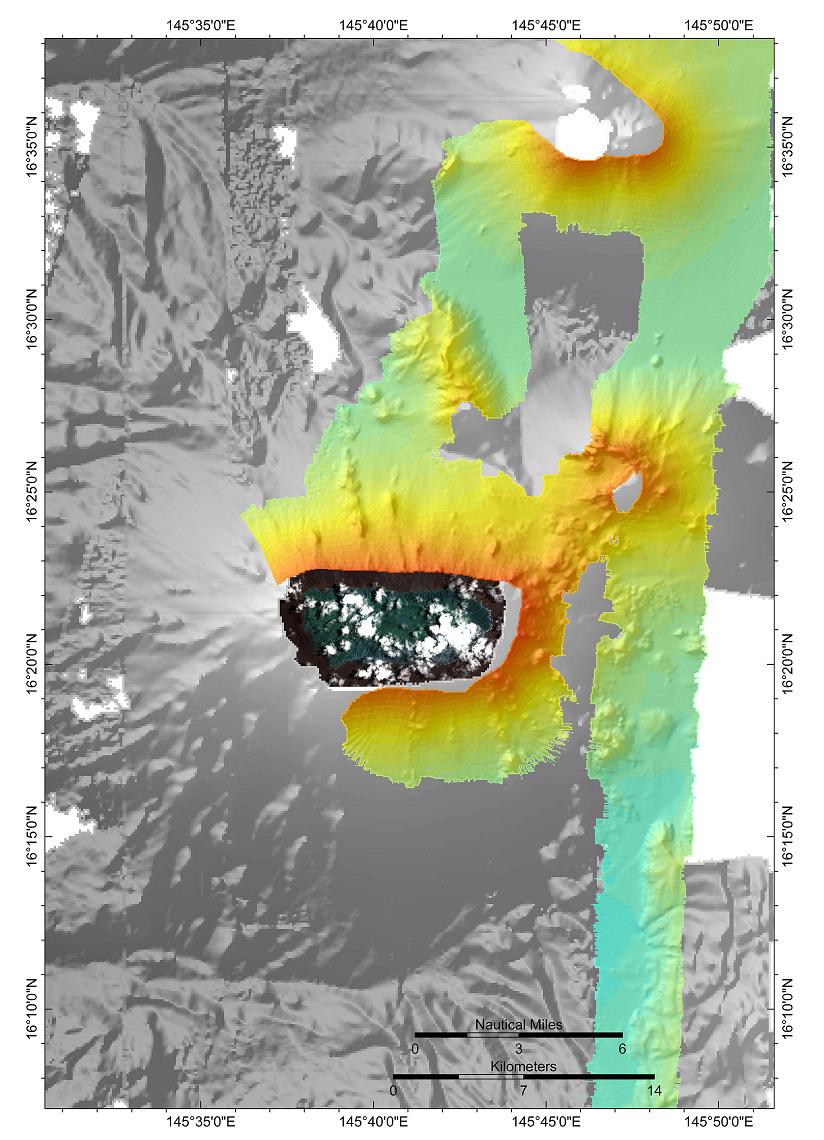
Guguan.Guguan has an eroded v olcano on the south, a caldera with a post-caldera cone and a northern volcano, which has a breached summit crater that fed lava flows to the west. The only known eruption took place between 1882 and 1884 and produced the northern volcano and lava flows that reached the coast.Multibeam sonar data were collected around Guguan in 2007 in water depths between 20 and 800 m on all sides and to almost 2000 meters on the eastern side. The multibeam bathymetry data show two shelves extending 2 km offshore around the southern portion of the island ¢ one in depths of 25 to 50 m and the second in 80 to 120 m depths. The steep underwater flanks of the volcano show much less evidence of mass wasting and erosion than do other volcanoes in the chain. Fifteen km to the southeast sparse multibeam data hint at a structure that may be similar to the one seen to the east of Sarigan http://www.soest.hawaii.edu/pibhmc/pibhmc_cnmi.htm |
Guguan |
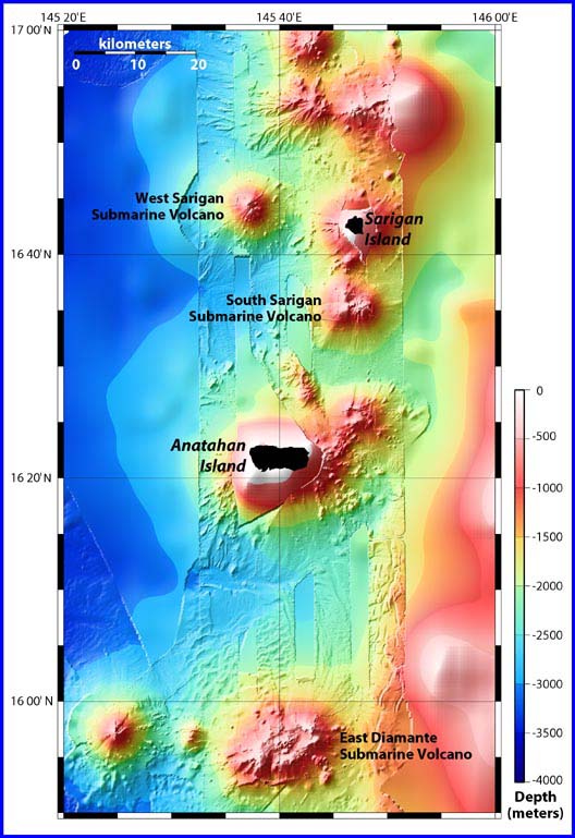
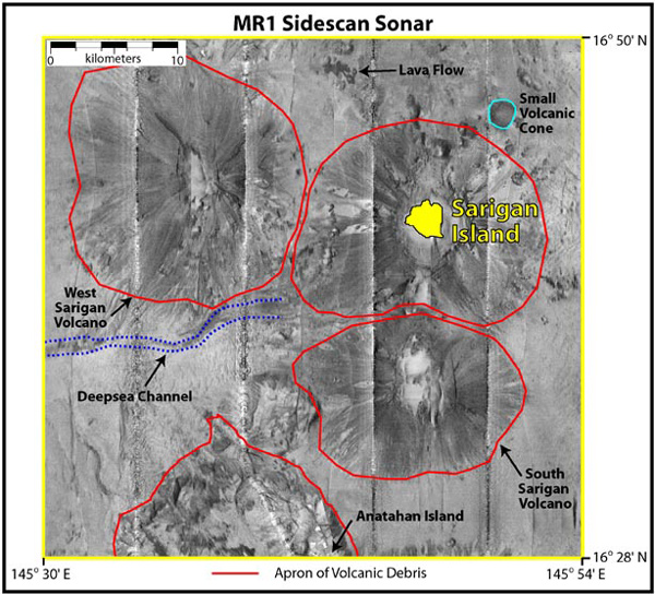
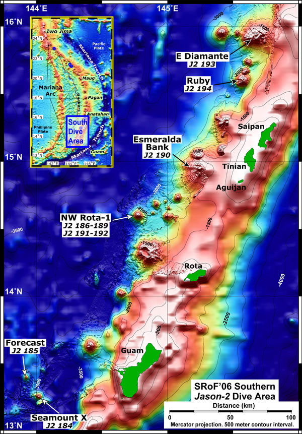
Location map showing East Diamante and Sarigan submarine volcanoes, as well as the volcanic islands of Sarigan and Anatahan. The bathymetry data are a combination of satellite bathymetry overlaid with EM300 multibeam bathymetry, which was collected on the present cruise.http://oceanexplorer.noaa.gov/explorations/03fire/logs/feb17/media/islands.html |
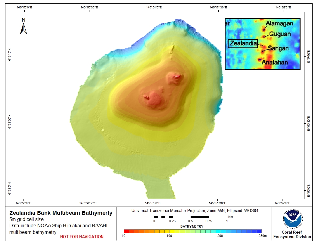
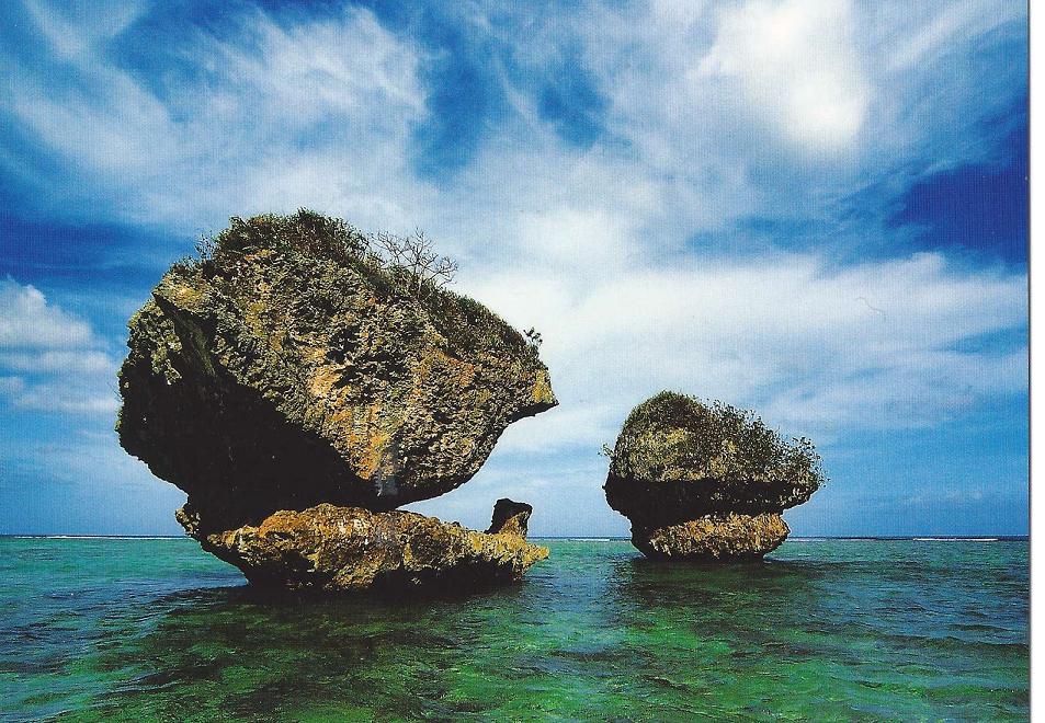
Zealandia Bank is located approximately 20 km north of Sarigan Island. This flat-topped bank with two pinnacles is surrounded by vertical walls. Rhodoliths, calcareous nodular bodies produced by algal accretion, and Halimeda algae beds were seen by video camera at depths of 115 m.http://www.soest.hawaii.edu/pibhmc/pibhmc_cnmi_zea.htm |
http://www.soest.hawaii.edu/pibhmc/pibhmc_cnmi.htm |
Sarigan - http://www.soest.hawaii.edu/pibhmc/pibhmc_cnmi_sar_bathy.htm |
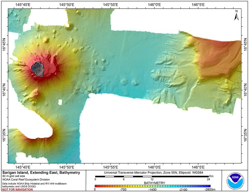
The Northern Mariana Islands have all been created by volcanic activity, but until now, only the small portion above the surface of the ocean has been known. The islands represent only a small percentage of the total volume of the mostly submarine volcanoes that rise from a depth of about 3,000 m. Note the spokelike patterns around Sarigan and the two adjacent submarine volcanoes, West Sarigan and South Sarigan, on the map at top right. The dark ribbons probably represent flows of coarse volcanic debris derived from eruptions at the summits of the volcanoes.Many of these eruptions are gas-rich and produce fragmental deposits of pumice, scoria and ash. Although more intact lava flows are seen on the flanks of the volcanoes in some places, the overall ōmessageö of this image is the ubiquitous downslope transport of the volcanic byproducts. The summit eruptions and resulting radial pattern of distribution of the volcanic products over time construct classic cone-shaped volcanoes.In addition, material from some of the larger flows continues further downslope and is transported through deep-sea channels formed between the volcanoes and westward into the deeper basin. http://oceanexplorer.noaa.gov/explorations/03fire/logs/feb17/feb17.html http://www.volcanolive.com/sarigan.html |
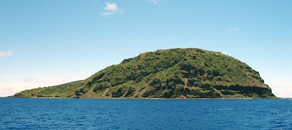
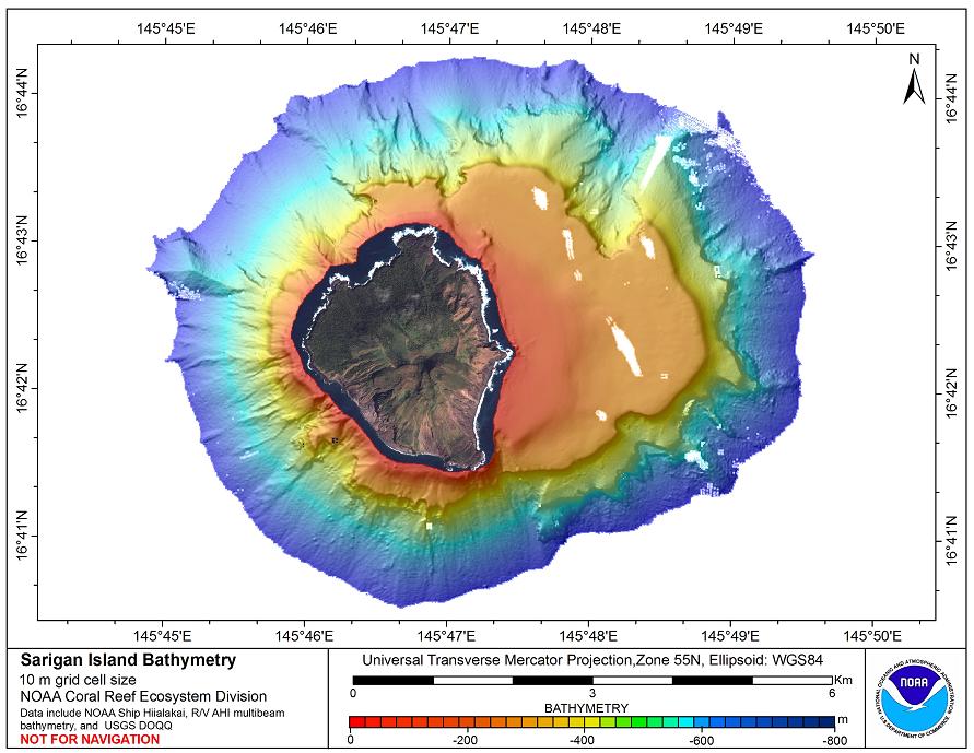
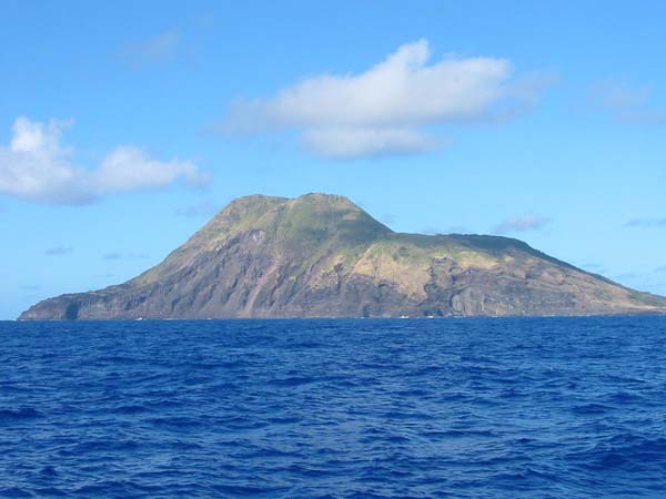
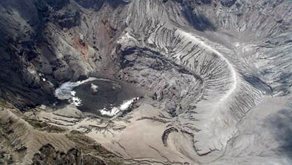
Sarigan Island, stratovolcano, 538m, viewed from the east, as the Thompson cruised by. The majority of volcanic islands in the Marianas chain are uninhabited http://oceanexplorer.noaa.gov/explorations/03fire/logs/feb17/feb17.html Sarigan volcano forms a 3-km-long, roughly triangular island. A low truncated cone with a 750-m-wide summit crater contains a small ash cone. The youngest eruptions produced two lava domes from vents above and near the south crater rim. Lava flows from each dome reached the coast and extended out to sea, forming irregular shorelines. The northern flow overtopped the crater rim on the north and NW sides. The sparse vegetation on the flows indicates they are of Holocene age. A swarm of volcano-tectonic earthquakes occurred at Sarigan volcano in June and August 2005. A submarine vent erupted 11 km south of Sarigan Island on 30th May 2010. An ash cloud reached a height of 8 miles. A large area of floating debris was observed south of Sarigan island, and discoloured water above the vent. A 0.5 m high tsunami was recorded at the island. The youngest eruptions produced two lava domes from vents near the south crater rim. Lava flows from the domes reached the coast and extended out to sea, forming irregular shorelines (Meijer and Reagan, 1981).http://www.volcano.si.edu/world/volcano.cfm?vnum=0804-192 |
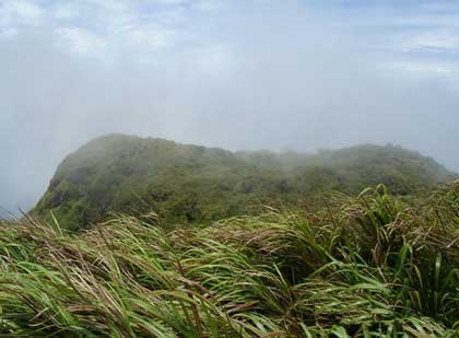
Sarigan volcano, Swordgrass.Sarigan volcano forms a 3-km-long, roughly triangular island. A low truncated cone with a 750-m-wide summit crater contains a small ash cone. The youngest eruptions produced two lava domes from vents above and near the south crater rim. Lava flows from each dome reached the coast and extended out to sea, forming irregular shorelines. The northern flow overtopped the crater rim on the north and NW sides. The sparse vegetation on the flows indicates they are of Holocene age (Meijer and Reagan, 1981). http://volcanoes.usgs.gov/about/volcanoes/nmi/sarigan.php Island Type: volcanic cone, radially dissected, coastal cliffs. The island has numerous ravines and valleys with dense tropical vegetation. Ecosystems: rain forest in ravines, Miscanthus grassland on upper slopes. Special features: archaeological sites; feral goats and pigs; proposed as marine sanctuary |
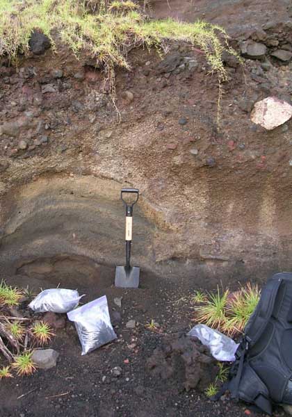
Sarigan volcano, pyroclastic layers |
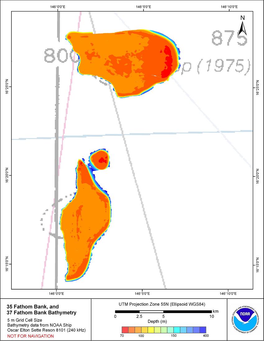
35 & 37 fthm Bank are located east of Anatahan, Commonwealth of the Northern Marianas (CNMI). They are one of the many islands and banks that form the Mariana Arc. These banks were first mapped during reconnaissance surveys of banks of potential fisheries interest, and were located by charted soundings on navigation charts. They were mapped aboard the NOAA ship Oscar Elton Sette during cruise SE-10-02, during which one mission was to map important fishery resources of Guam and CNMI. No local names for these banks are known, and they are therefore referred to here by the navigation chart sounding from which they were located.http://www.soest.hawaii.edu/pibhmc/pibhmc_cnmi_35fth_37fth.htm |
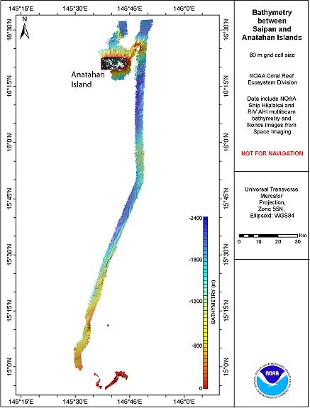
Anatahan -http://www.soest.hawaii.edu/pibhmc/pibhmc_cnmi.htm |
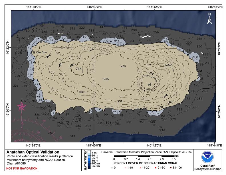
http://www.soest.hawaii.edu/pibhmc/pibhmc_cnmi_ana_optical.htm |
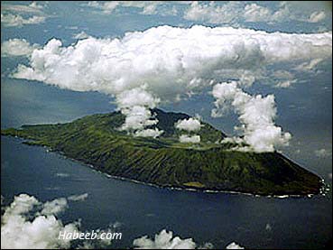
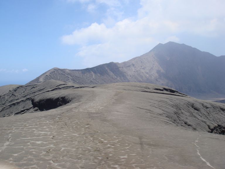
Anatahan volcano. Island type: high volcanic cone, dissected with ravines and ridges. Anatahan is a small island (6 by 2 miles, 9 by 3-km) made of overlapping calderas. The volcano has two peaks with a grass covered flat field. The island''s steep slopes are furrowed by deep gorges covered by high grass. The coastline is precipitous. Landing beaches are on the north and the west shore and a small sandy beach on the southwest shore.Ecosystems: rainforest, grassland on upper slopes. Species of conservation interest-Birds: Megapodius laperouse laperouse (Marianas Megapode) group endemic subspecies, Rare (RDB), possibly present |
The two coalescing volcanoes forming the elongate, 9-km-long island of Anatahan in the central Mariana Islands are apparent in this aerial view from the south. The low point in the center of the island results in part from overlapping 2.3 x 5 km wide calderas, the largest in the Mariana Islands. The larger western caldera is 2.3 x 3 km wide and extends eastward from the 788-m-high summit of the western volcano (left). The volcano''s first historical eruption in 2003 took place from a small crater within the 2-km-wide eastern caldera.Stratovolcano, 790m.The elongate, 9-km-long island of Anatahan in the central Mariana Islands consists of a large stratovolcano with a 2.3 x 5 km, E-W-trending compound summit caldera. The larger western portion of the caldera is 2.3 x 3 km wide, and its western rim forms the island''s 790-m high point. Ponded lava flows overlain by pyroclastic deposits fill the floor of the western caldera, whose SW side is cut by a fresh-looking smaller crater. The 2-km-wide eastern portion of the caldera contained a steep-walled inner crater whose floor prior to the 2003 eruption was only 68 m above sea level. A submarine volcano, named NE Anatahan, rises to within 460 m of the sea surface on the NE flank of the volcano, and numerous other submarine vents are found on the NE-to-SE flanks. Sparseness of vegetation on the most recent lava flows on Anatahan had indicated that they were of Holocene age, but the first historical eruption of Anatahan did not occur until May 2003, when a large explosive eruption took place forming a new crater inside the eastern caldera. Photo courtesy of U. S. Geological Survey, 1994http://www.volcano.si.edu/world/volcano.cfm?vnum=0804-20= |
http://www.soest.hawaii.edu/pibhmc/pibhmc_cnmi.htm |
A top of Anatahan volcano http://www.eri.u-tokyo.ac.jp/fmaeno/PHOTOS/mariana.html |
Anatahan crater 2007 |
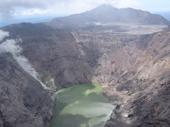
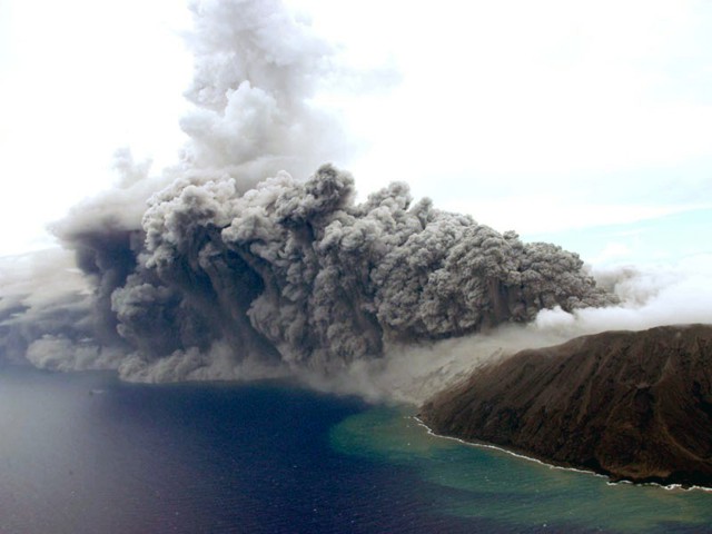
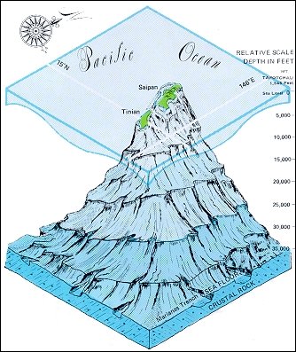
Island Anatahan is only 1% of the volume of the entire volcano, which is 3700 m high from submarine base to summit, and an average diameter of 35 km. The highest point on the island is immediately west of the caldera.Anatahan Island measures 9 km (east¢west) by 3.7 km (north¢south). The summit of the island contains an elongate caldera, 5 km by 2 km. The caldera is approximately 10 sq km in size and occupies about a third of the islandÆs area.The east crater is located in the eastern part of the caldera. It is a a pit crater 1.4 km by 1.2 km in diameter, and 200 m deep.Seismic activity increased at Anatahan volcano in January 2008. A faint ash plume to 2 km altitude was visible at Anatahan volcano on 28th July 2008. The largest eruption of Anatahan volcano occurred on April 6, 2005, when ash reached 50,000 ft altitude. The eruption ejected about 50 million cubic meters of ash. A plume of vog from that eruption spread over the Philippine Sea, reaching about 1200 nautical miles west of Anatahan.The first recorded eruption of Anatahan volcano occurred on 10th May 2003. Only sulfataric activity was observed previous to this eruption. The eruption ejected reddish brown ash to a height of 13 km. The eruption occurred from the east crater of the volcano. A swarm of volcano-tectonic earthquakes occurred on the 10th May 2003 northeast of the island preceded the eruption. At 0500 UTC, the earthquakes surged to more than 100 events per hour, with magnitudes less than 2. On 12th May Anatahan and surrounding waters to a distance of 48 km were declared off limits to boats and aircraft not involved in hazard evaluations. Moderate to vigorous activity continued until 28th May 2003. Between 28th May and 5th June, an ashfall and small surge passed through the east flank crater. Dome growth occurred between 5-14 June. The small lava dome was destroyed by an eruption on 14th June.2001 Geothermal Activity: In June 2001 there was a small increase in the area of geothermal activity around a couple of pits at the volcano.1992-94 Seismicity: A few swarms of small, local, earthquakes occurred at Anatahan volcano between May¢July 1993. Nine earthquakes larger than magnitude 4.5 occurred between late 1992 and May of 1994.1990 Earthquakes:In March and April 1990, increased local seismicity, a large regional earthquake, and reported increased fumarolic activity in the pit crater, resulting in the evacuation of Anatahan village, at the west end of the island. A helicopter overflight noted a change in the pit crater lake from its typical green color to bluish gray, increased fumarolic activity, a fresh landslide in the pit crater, and the odor of H2S. On 5th April 1990, a magnitude 7.5 earthquake occurred 150 km east of Anatahan, in the Mariana trench. Eruptions: 2008, 2006, 2005, 2004, 2003 http://www.volcanolive.com/anatahan.html |
Anatahan has no known historical eruptions. Recent activity includes a period of felt earthquakes that began on March 30, 1990. Felt earthquakes continued for two more days. An over flight revealed that the crater Lake in the east part of the main caldera had become turbulent and changed color. The intensity of fumaroles had increased and the smell of rotten eggs was reported. The volcanic unrest caused the evacuation of the island''s 23 residents. A field investigation found a deposit from a phreatagmatic eruption that is younger than human occupation of the island. Overflows of hot acidic water from the lake had killed a large area of vegetation. Tilt on the flank of the volcano had not changed. Electronic distance measurements measured extension across the volcano up to about 3.5 inches (91 mm). Volcanologists returned to the island in late June. During their 2-day visit, no earthquakes larger than magnitude 2.5 were recorded. Measurements of deformation revealed no significant changes since April. However, the crater lake had disappeared and was replaced by several pits and the area was vigorously steaming. Swarms of earthquakes occurred again at Anatahan in late May to early June of 1993. The island was declared off limits. No eruption occurred http://www.guam.net/pub/sshs/depart/science/mancuso/marianas/anatahan/anatahan.htm |
Anatahan volcano.Lava flows composed of a basement of the volcano -http://www.eri.u-tokyo.ac.jp/fmaeno/PHOTOS/mariana.html |
Anatahan volcano.Latest plinian fallout deposits.http://www.eri.u-tokyo.ac.jp/fmaeno/PHOTOS/mariana.html |
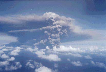
Anatahan is one of the most active volcanoes of the Northern Mariana Islands. Anatahan Volcano eruption, May 11, 2003. Image courtesyof Dr. Allan Sauter, SCRIPPS. Anatahan Volcano, located in the northern Marianas islands, began erupting on May 10, only 3 months after the research vessel Thomas G. Thompson surveyed its flanks during the 2003 Submarine Ring of Fire expedition. During our survey in February, we found that young lava flows cover large areas on the submarine flanks of the island, so even though Anatahan had not erupted previously in historical times, it was clear that the volcano was only dormant and potentially active. The five hydrophones that we deployed during the Ring of Fire expedition (and due to be recovered in September 2003) will show whether or not there was any precursory activity leading up to the eruption http://oceanexplorer.noaa.gov/explorations/03fire/logs/anatahan/anatahan.html http://hvo.wr.usgs.gov/cnmi/ |
Photograph taken on 10 May 2003 of an ash cloud produced from the eruption of Anatahan that began that day. The cloud top is at ~ 4.6 km and emanates from the eastern crater. The view is toward the SW. Courtesy of CNMI Emergency Management Office.- http://www.volcano.si.edu/world/volcano.cfm?vnum=0804-20=&volpage=var#bgvn_2804 |
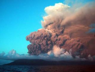
A dark ash cloud rises from a vent at the east crater (far right) of Anatahan as seen from a helicopter looking NW on August 24, 2005. Eruptive activity had begun in 2004, when a new lava dome was seen on April 12, along with fresh ejecta at the bottom of the crater. Intermittent explosive activity occurred throughout the year. In 2005 the 2003 crater floor was almost entirely covered by fresh lava out to a diameter of ~ 1 km. Powerful explosive eruptions in April, June, and July 2005 sent eruption plumes to as high as 15 km. Photo by Takeshi Matsushima, 2005 (Kyushu University).http://www.volcano.si.edu/world/volcano.cfm?vnum=0804-20= |
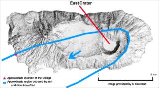
Map of Anatahan showing the deep pit on the eastern side of the summit, which is referred to as the East Crater, and is the source of the eruption that began on 10 May 2003. Courtesy of Scott Rowland, University of Hawaii Manoa- http://www.volcano.si.edu/world/volcano.cfm?vnum=0804-20=&volpage=var#bgvn_2804 |
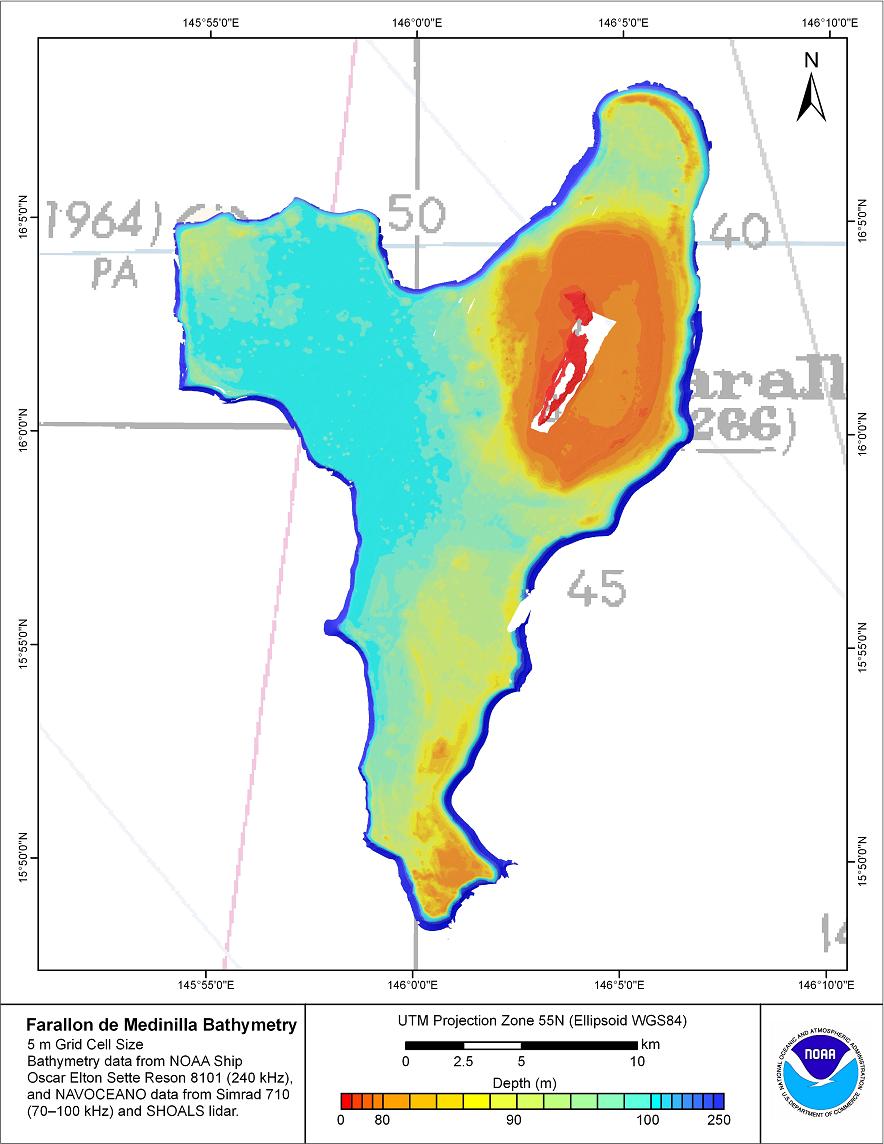
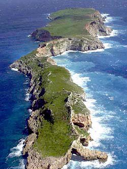
Farallon de Medinilla (FDM) is a small island in the Northern Mariana Islands chain and is situated 45 nautical miles (83 km; 52 mi) north of Saipan. It is the second smallest in the chain; only Zealandia Bank is smaller. It is an uninhabited coral island which is 0.845 km▓ (0.326 sq mi, or 208.9 acres) in area. It is 2.8 km long from southwest to northeast. The southern part is up to 150 meters wide, and the northern part up to 520 meters. At its narrowest, where the northern and southern parts join, the island is only about 20 meters wide. Its highest elevation is 81 meters. The shores are rimmed with cliffs containing caves and its tableland has some brush and savanna grass.For years, the U.S.Navy has used Farallon de Medinilla for military and bombing exercises. In a 2002 lawsuit, the Center for Biological Diversity charged the Navy with the destruction of wildlife habitat on the island. A subsequent court ruling ordered the U.S. Defense Department to cease bombing exercises on Farallon de Medinilla until they came in compliance with the Migratory Bird Treaty Act -http://www.soest.hawaii.edu/pibhmc/pibhmc_cnmi_fdm.htm |
Farallon de Medinilla Elevation: 788m, or 81 m depending on the source! Island type: raised coral ridge with flat top, coastal cliffs, and chasm between two parts. This is a coral island with deep caves. It is less than half a square mile in area and is tableland with low vertical sides covered by bush and savanna grass. The shores have low cliffs with caves on the south and west sides.Ecosystems: limestone scrub.Special features: signs of frequent landslides. used as a military bombing range since 1971 http://www.guam.net/pub/sshs/depart/science/mancuso/marianas/fdm/med.htm |
Farallon de Medinilla |
Farallon de Medinilla |
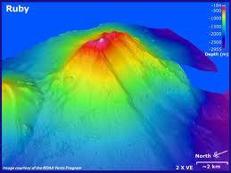
Ruby Seamount is a submarine volcano associated with the subduction of the Pacific Plate beneath the Philippine Plate. The seamount is located 25 m northwest of Saipan. The last eruption, detected by submarine hydrophones, was in 1966. In mid-October of 1995, fisherman reported discolored water near the seamount. Personnel of the Wildlife and Emergency Management Office (EMO) of the Commonwealth of the Northern Mariana Islands visited the site and measured a depth to the volcano of 200 m. Later, fisherman reported "explosions" in the area. EMO personnel returned on October 25, 1995, and confirmed the submarine explosions. They measured a new depth to the volcano of 60 m. This could be interpreted as vertical growth of the volcano of 140 m in a short time. However, since the type of navigation used by the ship is unknown, they may have made two measurements at different locations. An earlier tsunami alert for the islands of Saipan, Rota, and Tinian has been cancelled. Potential collapse of part of the volcano prompted the alert. Reports dated October 25, 1995, stated that the eruption had died down. Pagan, a volcanic island north of Ruby Seamount, erupted in 1993. http://www.cartage.org.lb/en/themes/sciences/earthscience/Geology/volcanoes/currentvolcanoes/RubySeamont.htm http://vulcan.wr.usgs.gov/Volcanoes/NorthPacific/ http://www.guam.net/pub/sshs/depart/science/mancuso/marianas/saipan/saipan.htm http://oceanexplorer.noaa.gov/explorations/06fire/logs/summary/media/srof06_south_dives.html |
|
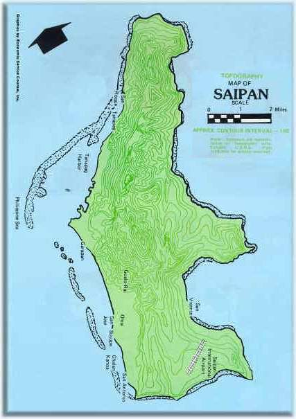
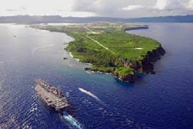
Saipan Island (and Marpi Bank). Saipan,474m is The measurement from the floor of the Marianas Trench to the crest of Mount Tapotchau is 37,752 feet or 7.15 statute miles, (from sea level Mount Everest measures 29,028 feet). Saipan''s coastline is irregular except on the western side where there is a fringing reef. Saipan is urbanized area. Ecosystems: scrub and secondary vegetation of Acacia confusa, Casuarina, and coconuts; grasslands; possibly cloud forest on Mt. Tapachau; many introduced species.Special Features: Lake Susupe; enclosed marine grotto; green turtle nesting on Tanapag beach; Tanapag Lagoon proposed as marine sanctuary.Endemism: 1 endemic bird.Species of Conservation Interest: Birds Anas oustaleti (Marianas Mallard) * group endemic, Lake Susupe and mangrove area north of Garapan, Endangered (RDB), not sighted since 1979. Megapodius laperouse laperouse (Marianas Megapode) group endemic subspecies, Rare (RDB), possible recolonization in late 1970s. Gallinula chloropus guami (Marianas Gallinule or Common Moorhen) group endemic subspecies, Lake Susupe, Rare (RDB), 2 reported on Lake Susupe (1975). Cleptornis marchei (Golden Honeyeater) endemic Acrocephalus luscinia luscinia (Nightingale Reed Warbler) 6 colonies at Lake Susupe, uncommon. Ptilonopus roseicapilla (Marianas Fruit Dove) group endemic, Guam, Rota, Tinian, Saipan, Vulnerable (RDB), uncommon locally (1977).http://www.guam.net/pub/sshs/depart/science/mancuso/marianas/saipan/saipan.htm |
Saipan Island (and Marpi Bank) |
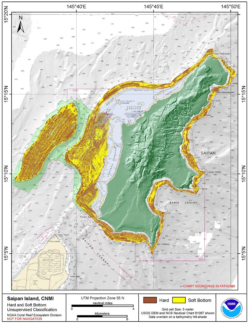
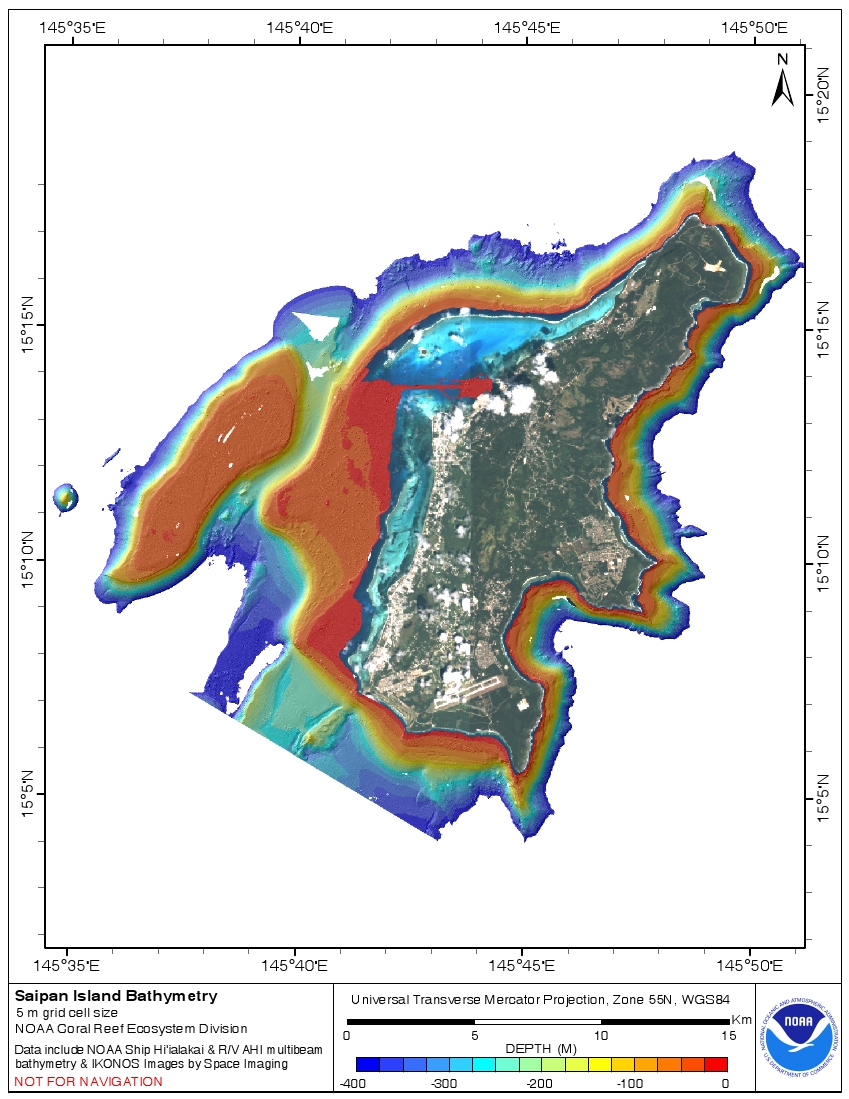
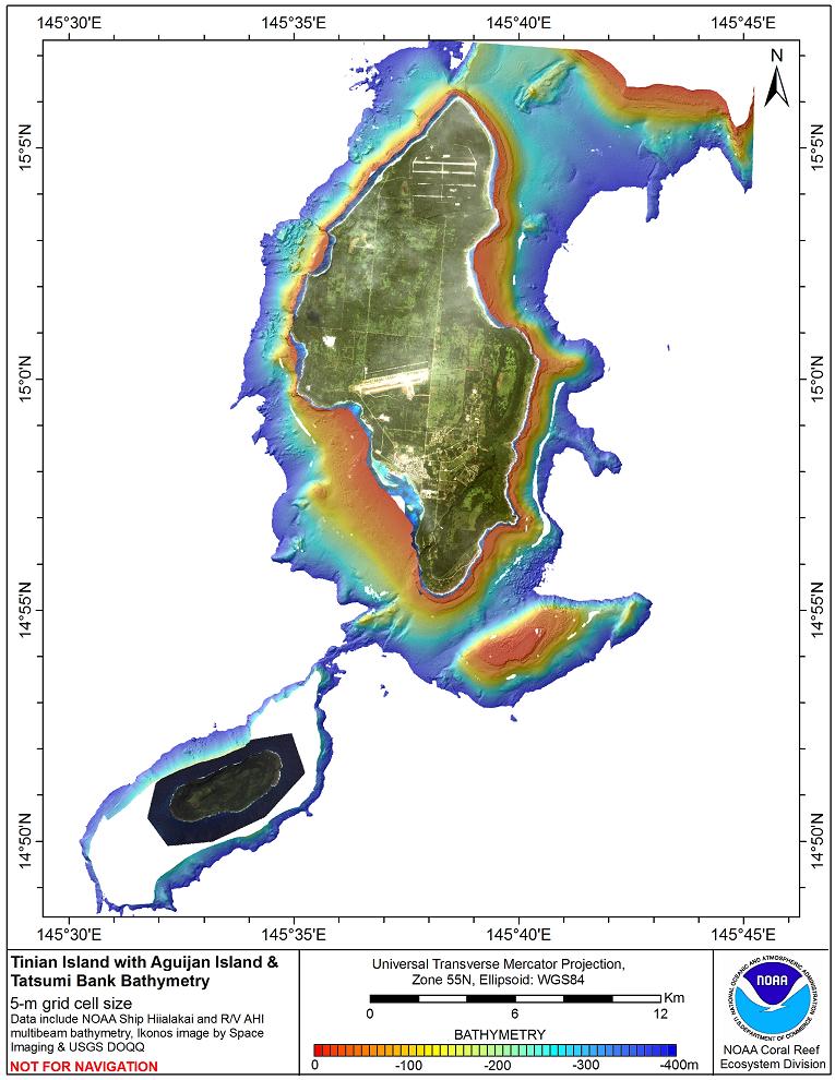
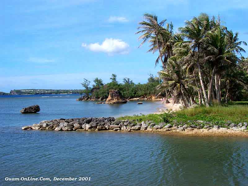
Saipan Island (and Marpi Bank)Saipan is approximately 20 km long and 9 km wide with an area of 122 km2. Of the eight communities on Saipan, Garapan and Chalan Kanoa are the principal population centers. Saipan, the largest of the Northern Mariana Islands, consists of a volcanic core enveloped by younger coral reef-derived limestone formations. It has the most diverse coral reefs in the CNMI-Guam region, although coral habitat on two large offshore banks are threatened by the anchorage of commercial and naval vessels. Marpi Bank is a steep-sided, flat-topped submerged bank approximately 28 km north of Saipan. It is approximately 9 km long by 4 km wide and is oriented in a northeast to southwest alignment similar to Tatsumi Reef, which lies south of Tinian. The shallowest point shown on NOAAÆs Nautical Chart 81067 is 26 fathoms (53 m). Marpi Bank is also a popular fishing location. In 2003 and 2007 Marpi Bank was surveyed using multibeam sonars on the R/V AHI and the NOAA Ship HiÆialakai http://www.soest.hawaii.edu/pibhmc/pibhmc_cnmi_sai.htm |
http://www.soest.hawaii.edu/pibhmc/pibhmc_cnmi.htm see geologic section - http://pubs.usgs.gov/wri/wri034178/pdf/fig04b.pdf |
Saipan |
Offshore Saipan |
Saipan |
Saipan |
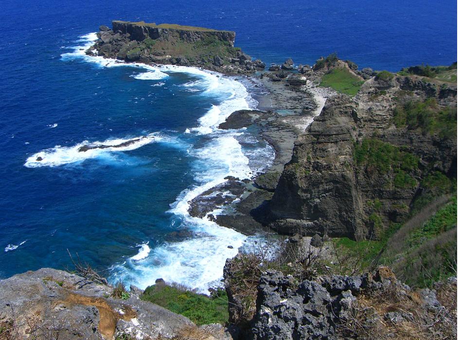
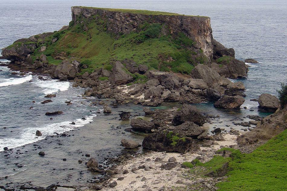
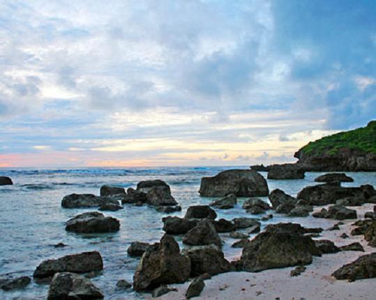
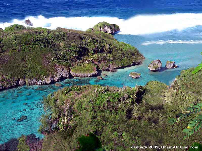
Forbidden Island |
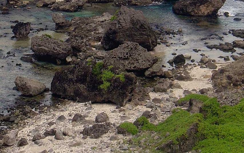
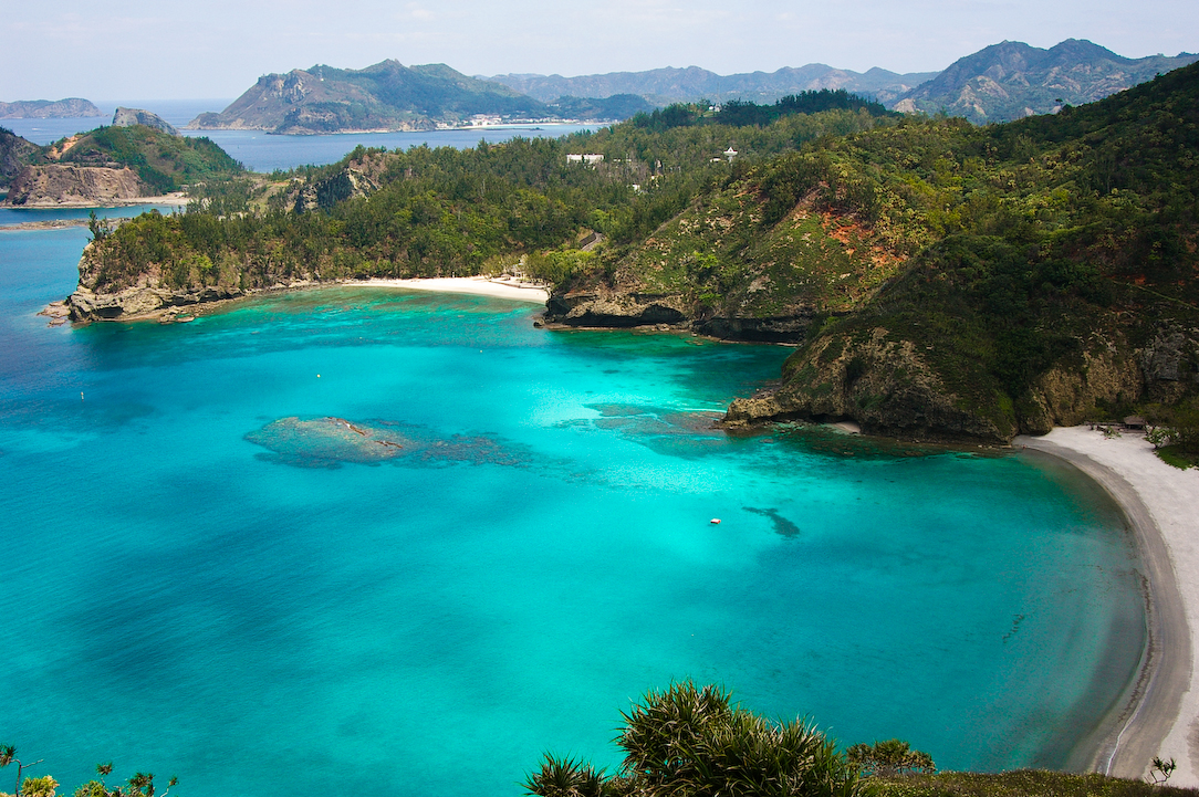
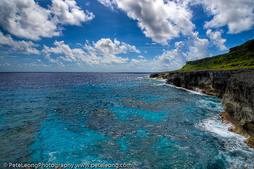
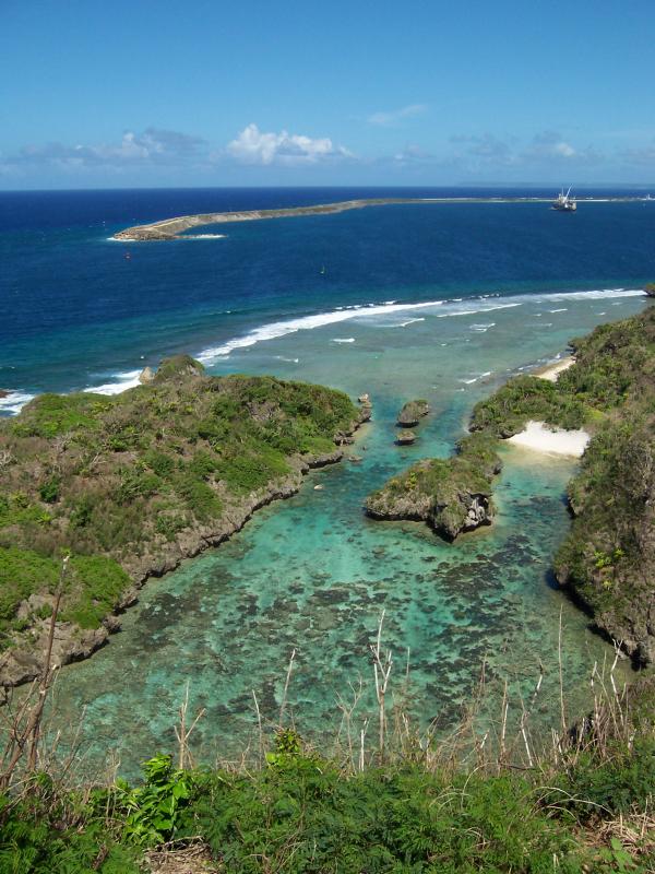
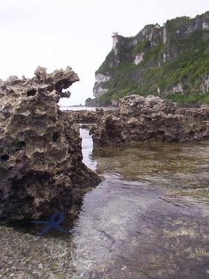
The flat-topped Forbidden Island, an uplifted fossil coral reef platform on the island of Saipan http://www.soest.hawaii.edu/pibhmc/pibhmc_cnmi.htm |
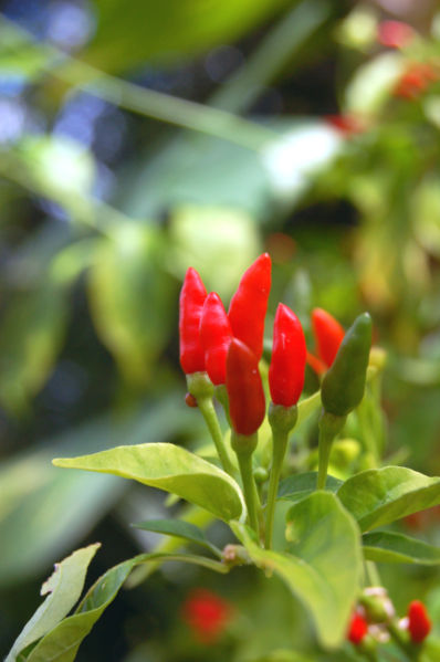
Thai hot peppers, or tinian peppers, growing wild.-http://en.wikipedia.org/wiki/Saipan |
Saipan |
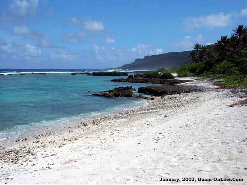
Saipan. The western side of the island Saipan is lined with sandy beaches and an offshore coral reef which creates a large lagoon. The eastern shore is composed primarily of rugged rocky cliffs and a reef. Its highest point is a limestone covered mountain called Mount Tapochau at 480 m. Many people mistakenly believe Mount Tapochau to be an extinct volcano, but it is in fact a limestone formation. To the north of Mount Tapochau towards Banzai Cliff is a ridge of hills. Mount Achugao, situated about 3km north, has been interpreted to be a remnant of a stratified composite volcanic cone whose Eocene center was not far north of the present peak. http://en.wikipedia.org/wiki/Saipan see geology on http://pubs.usgs.gov/wri/wri034178/htdocs/wrir03-4178.html |
Saipan |
Saipan, Bird Island |
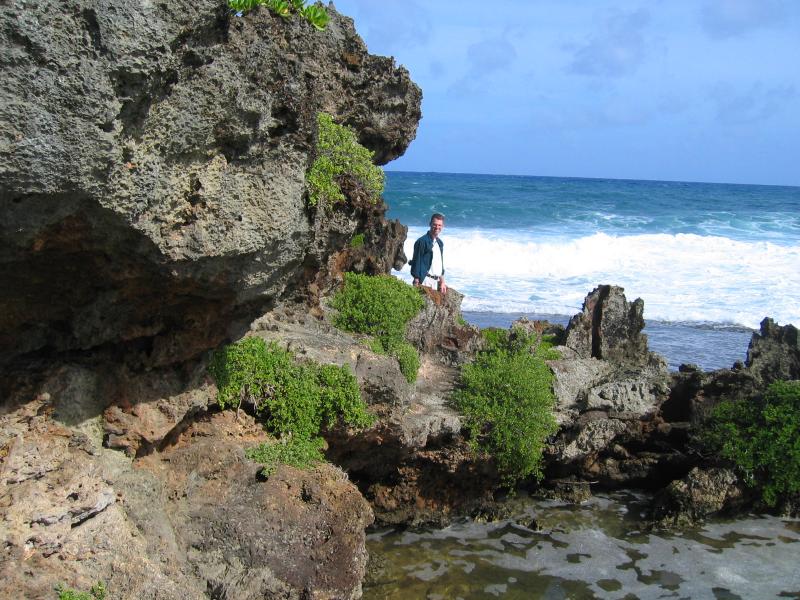
Aguijan Island (also spelled Aguigan) lies 8 km southwest of Tinian Island. This small island measures only 4 km by 1 km with an area of about 7.3 km2. Its maximum elevation is 57 m and steep cliffs surround the island; thus it is uninhabited and seldom visited. Island type: steep cliffs to north.Once stocked with goat for food, the introduced species was removed as it began to defoliate the island. The island is surrounded by sheer, steep cliffs and is very difficult to approach by sea. For this reason, it is the location of the last of the ancient Chamorro resistance to the Spanish colonial rule in 1695. Aguihan is presently uninhabited.Human impact: visited occasionally.Special Features: feral goats and pigs; proposed as marine sanctuary. Birds Acrocephalus luscinia rigor (Nightingale Reed Warbler), Ptilinopus roseicapilla (Marianas Fruit Dove) group endemic, Vulnerable (RDB). http://www.guam.net/pub/sshs/depart/science/mancuso/marianas/aguihan/aguihan.htm |
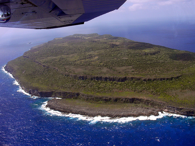
Tinian island type: raised coral, approximately 16 km long by 8km at its widest point. The highest point, Puntan Carolinas, is 200m above sea level. Human impact: pop. 714 (1973); heavily cultivated by Japanese;Ecosystems: limestone forest and scrub, mostly secondary growth; many introduced plants.Special Features: Small Lake Hagoi in center; important archaeological sites; patch reef south of harbor proposed as marine sanctuary. bird Gallinula chloropus guami (Marianas Gallinule or Common Moorhen) - group endemic subspecies, Lake Hagoi and Marpo Swamp, Rare (RDB) - only 1 observed locally (1974). Monarcha takatsukasae (Tinian Monarch) - endemic, Ptilinopus roseicapilla (Marianas Fruit Dove) - group endemic, Guam, Rota, Tinian, Saipan, Vulnerable (RDB), rare on Tinian Anas oustaleti (Marianas Mallard) - group endemic, Endangered (RDB), possibly present, Lake Hagoi.http://www.guam.net/pub/sshs/depart/science/mancuso/marianas/tinian/tinian.htm http://www.soest.hawaii.edu/pibhmc/pibhmc_cnmi_tin.htm |
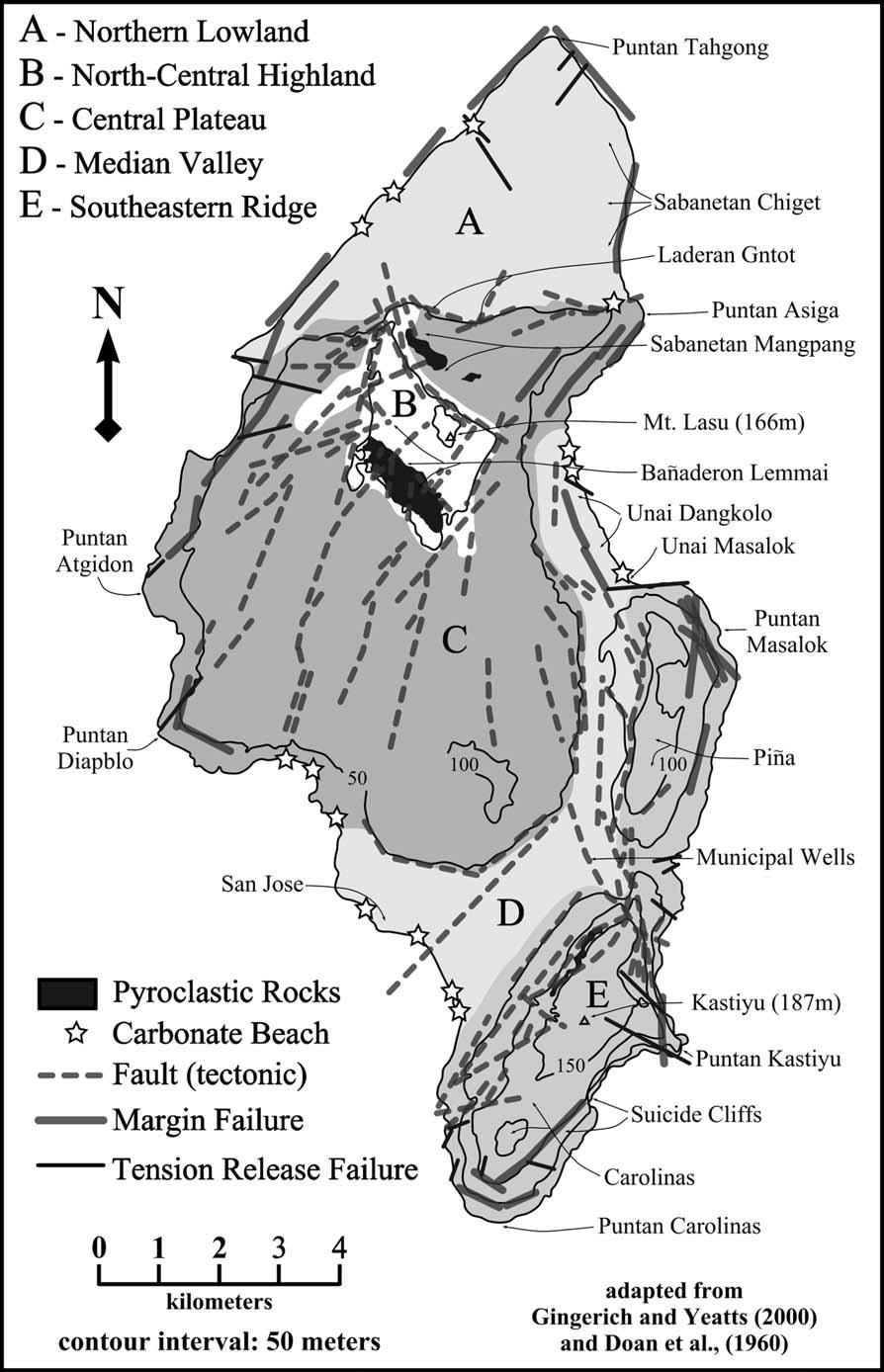
Map of Tinian showing important locations, physiographic provinces, igneous outcrops, brittle failure features,and beaches (constructional coastlines) (adapted from Doan et al. 1960). http://www.caves.org/pub/journal/PDF/V67/v67n1-Stafford.pdf |
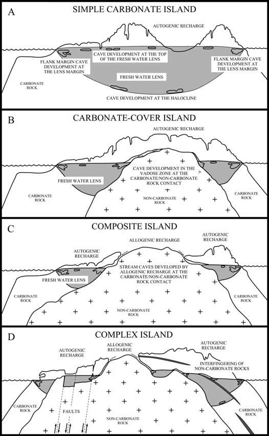
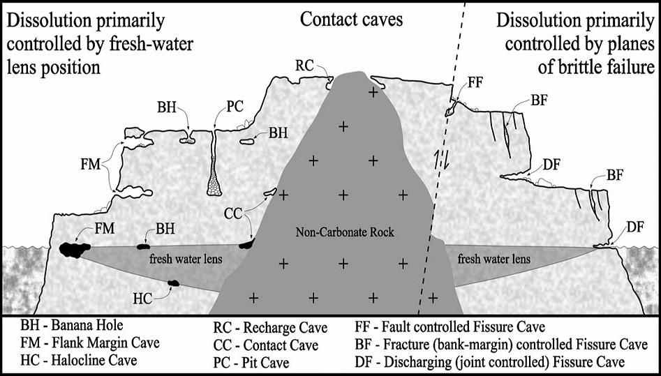
Carbonate Island Karst Model illustrating the 4 categories of carbonate islands that exist, based on variations in basement/sea-level relationships (adapted fromMylroie et al. 2001). http://www.caves.org/pub/journal/PDF/V67/v67n1-Stafford.pdf |
Schematic diagram illustrating the types of subsurface karst development on carbonate islands. Note that not all cave types occur on all carbonate islands http://www.caves.org/pub/journal/PDF/V67/v67n1-Stafford.pdf |
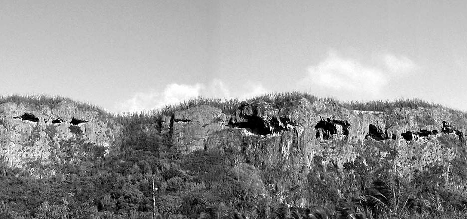
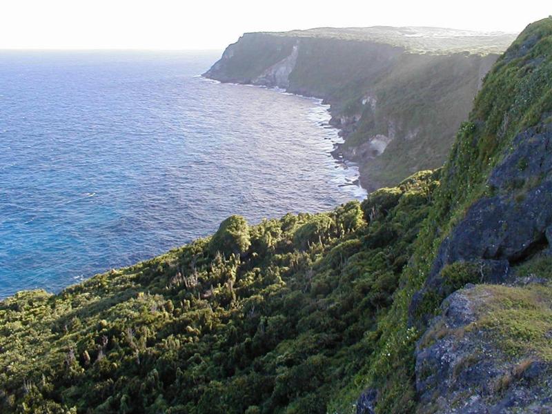
Suicide Cliffs on Tinian is an excellent example of mixing zone cave development along consistent horizons defined by previous sea-level stillstands. Note that most entrances are approximately 2.5 m tall http://www.caves.org/pub/journal/PDF/V67/v67n1-Stafford.pdf |
The geology of Tinian is also interesting. Tinian, Saipan and Aguijan are the worn down peaks of an ancient volcano. This volcano extends more 6 miles above the Marianas trench, which is the deepest point in any ocean on earth. Over the years, the wind and water eroded the peaks and created the caves that everyone liked to explore and where the Japanese liked to hide. Starting in prehistoric times, sea creatures left deposits encrusting Tinian with limestone and coral. Or in the accurate but indecipherable language of a geologist: " Tinian * * * is composed of Eocene volcanic rocks mantled by Miocene and Plio-Pleistocene coralline and algal limestone and Holocene raised beach and reef deposits."Sometime later, Tinian was also covered by a load of crap (among other things), creating the soil which supported plant life and made Tinian suitable for grazing cattle and growing sugar cane. http://philcrowther.com/6thBG/6bgtinian_history.html http://www.caves.org/pub/journal/PDF/V67/v67n1-Stafford.pdf |
A multibeam survey of Esmeralda Bank was carried out during the NOAA Ring of Fire cruise in April 2004. The Bank appears to have experienced recent volcanic activity and shows signs of current hydrothermal circulation http://www.soest.hawaii.edu/pibhmc/pibhmc_cnmi_esm.htm |
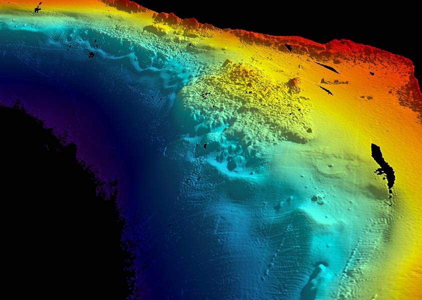
Rota islands. Multibeam bathymetry in Sasanhaya Marine Preserve http://www.soest.hawaii.edu/pibhmc/pibhmc_cnmi.htm |
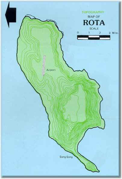
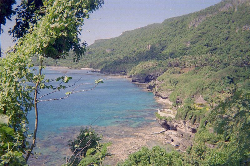
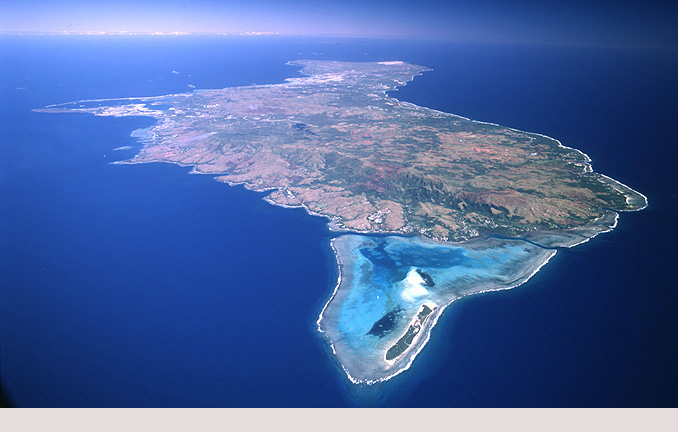
Rota Island : high volcanic surrounded by raised coral terraces see http://plate-tectonic.narod.ru/mariana3photoalbum.html. The Treasure Island - is approximately 16 km long and 6 km wide with. The highest elevation is Mt. Manira at 525 m. Human impact: pop. 1,104 (1973); market gardening.Ecosystems: rainforest on upper terraces with rare and endemic plants; grasslands and scrub on volcanic slopes; fringing reef.Special Features: vegetation of considerable conservation interest; parts of fringing reef and submarine terrace proposed as marine sanctuary.Endemism: 1 sp. bird. Plants: Serianthes nelsonii (Leguminosae) endemic to Rota and Guam, Endangered (RDB), Tabernaemontana rotensis, rare on Rota, one tree on Guam., Hernadia labyrinthica group endemic, rare, Boerlagiodendron sp., group endemic Heritiera longipetiolata (Sterculiaceae) group endemic, Endangered (RDB), Xylosoma nelsonii Rota and Guam. Birds: Ptilinopus roseicapilla (Marianas Fruit Dove) group endemic, Guam, Rota, Tinian, Saipan, vulnerable (RDB), common locally (1977), Zosterops conspicillata rotensis (Rota Bridled White-eye) endemic subspecies, forest on Sabana plateau, Indeterminate (RDB), Corvus kubaryl (Marianas Crow) endemic to Rota and Guam, Endangered (RDB), less than 100 (1976) http://www.guam.net/pub/sshs/depart/science/mancuso/marianas/rota/rota.htm |
Rota |
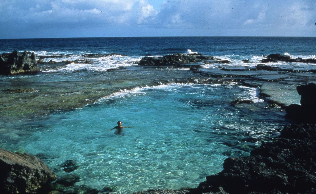
Rota swimming pool |
End of Rota |
Guam |
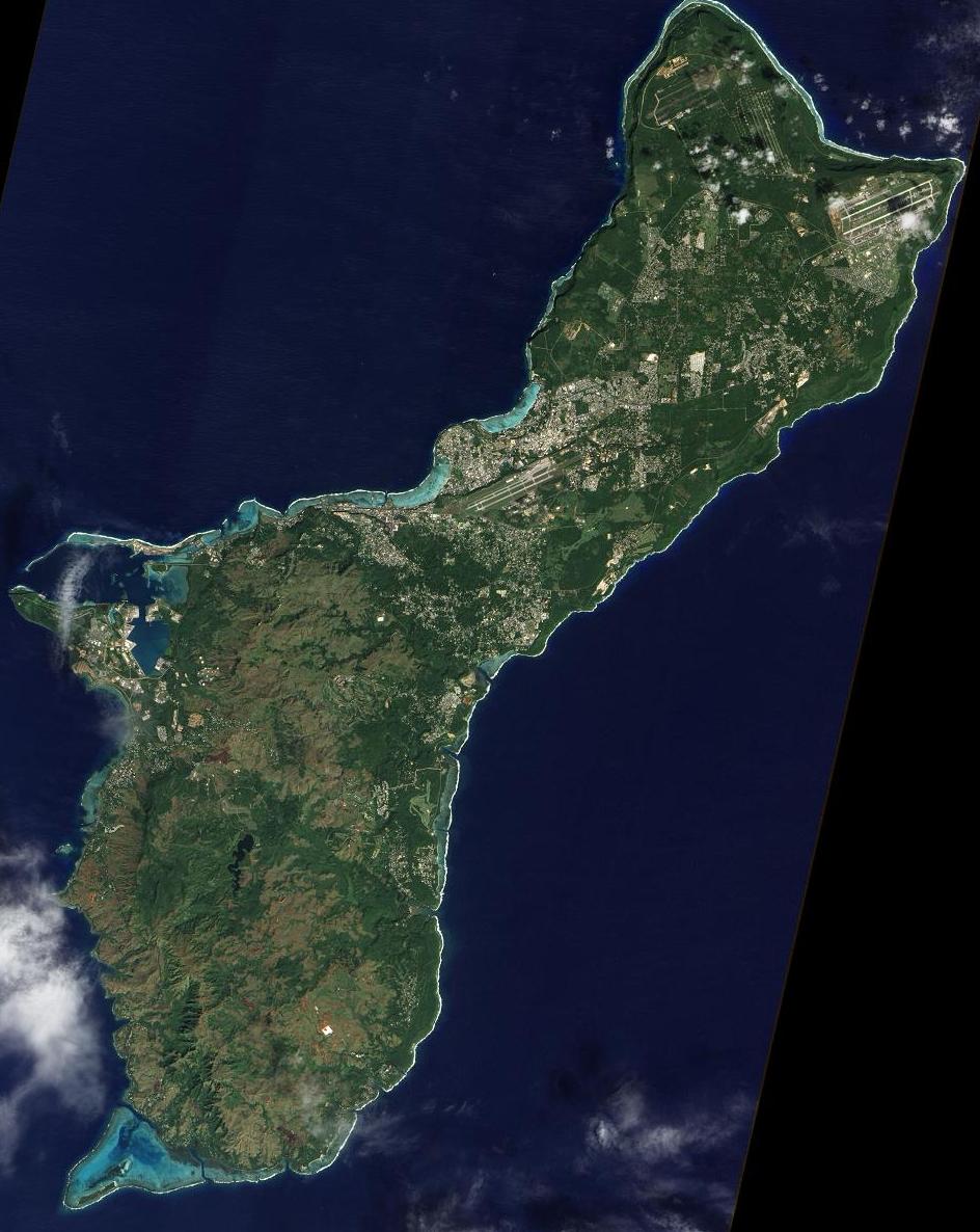
An unobstructed view of the island of Guam from NASA''s Earth Observing-1satellite. The island experiences occasional earthquakes magnitudes ranging from 5.0 to 8.7. Guam is not volcanically active.A coral table reef with deepwater channels surrounds most of Guam. Sandy beaches, rock cliff lines and mangroves characterize the coastline area. Sheer limestone coastal cliffs dominate the north, while the southern end of the island is mountainous, with lower hills in between - http://en.wikipedia.org/wiki/Guam |
Aga point southernmost. Island type Guam: raised coral in north (152 m); old weathered volcanic in south. The island 48km in length with a variable width, ranging from 19 km to 7km at its narrowest point. The largest island in Micronesia, excluding reef formations. The island has two basic geological compositions. Two-thirds of Guam, the central and northern features, are primarily raised limestone with several volcanic formations at Mount Santa Rosa and Mount Mataguak. The northern cliff lines drop precipitately into the sea with an elevation ranging from 100 to 200 m. The southern features are basically volcanic with an elongated mountain ridge dividing the inland valleys and coastline. The highest point is Mount Lamlam with an elevation of 450m. The Peak of a submerged mountain, Guam, rises 13,000 m above the floor of the Marianas Trench just east of Guam. The British Survey Ship Challenger pinpointed the Marianas Trench in 1951, and on January 23, 1960, the manned U.S.N. bathyscaph Trieste descended to the bottom. Guam straddles the edge of the Philippine Plate with the Pacific Plate thrusting below it. The Western shoreline faces the Philippine Sea while just a few miles away the Eastern beaches faces the Pacific Ocean. Ancient perpendicular fault lines that collect water now determine paths of existing tributaries. Guam is the "Isle of Orthogonal Rivers", and westernmost U.S. territory. It is west of the International Dateline and is 1 day ahead of the U.S.: Hence the slogan "Where America''s Day Begins". Human impact: heavy damage during WWII; extensive urban development around Hagatna and elsewhere; major military bases; some agriculture.Ecosystems: lowland rainforest on limestone with considerable endemism (remaining fragment along extreme northern rim); some ravine and beach forests; possible cloud forest on Mt. Lamlam; savanna and grasslands, scrub; poor mangroves; marsh, reed swamp and other aquatic habitats; fringing reef, lagoons and barrier reef (CRD).Features: Lake Fena (manmade); seabird rookeries at Anae islet and Orote Point; former sea turtle nesting beaches; caves in south with endangered swiftlet; feral pigs and other domestic animals; introduced giant African snail (Achatina fulica), elk, monitor lizard (Varanus indicus) and Philippine Rat Snake (Boiga irrgularis, 1947) with effects on native flora and fauna.Endemism: plants 330, insects 15, reptiles and amphibies 10, birds 12, mammels 4 http://www.guam.net/pub/sshs/depart/science/mancuso/marianas/guam/guam.htm |
.Apra Harbor on Guam western coast.Plants:931 [or 530] species of flowering plants and ferns, of which at least 330 are native, 69 are endemic to the Mariana Islands; 20 endemics and more than 30 non-endemics threatened on Guam, including: Serianthes nelsonii (Leguminosae) endemic to Guam and Rota (4 remaining trees on Guam), Endangered (RDB) Heritiera longipetiolata (Sterculiaceae) group endemic, Endangered (RDB) Tabernaemontana rotensis (Apocynaceae) one remaining tree on Guam Hernandia ovigera (Hernandiaceae) Merrilliodendron megacarpum (Icacinaceae) known from two areas Xylosoma nelsonii (Flacourtaceae) Fagraea galilai (Loganiaceae) two sites icluding Mt. Lamlam, Solanum guamense few plants known, Ceratopteris gaudichaudii from freshwater areas, Potamogeton mariannensis from freshwater, Coral area. Insects; 15 species of butterfly, 1 only on Guam: Neptis guamensis endemic, not seen since type collection in 1916, Other invertebrates: 9 native land snails, including 4 Partulidae (tree snails): Partula gibba, Partula salifana, Partula radiolata, Samoana fragilis http://www.guam.net/pub/sshs/depart/science/mancuso/marianas/guam/guam.htm |
Inarajan Pools Guam''s southeastern- http://www.paxgaea.com/Guam.html |
Ritidian Point- Guam''s northernmost point- http://www.paxgaea.com/Guam.html |
Guam |
Orote Point- Guam''s westernmost point. Reptiles-amphibians: Ramphotyphlops (?) pseudosaurus (Typhlopidae) endemic?. Birds : 95 species, 17resident, 7 introduced, 12 indigenous terrestrial bird species, 2 endemic:Rallus owstoni (Guam Rail) endemic, Vulnerable (RDB), fewer than 100 (1984), declining, Ptilinopus roseicapilla (Marianas Fruit Dove) group endemic, northwest forest, Vulnerable (RDB), estimate of 241 on Guam (1981), Myiagra freycineti (Guam Flycatcher of Broadbill) endemic, dangered, fewer than 100 (1983), Gallinula chloropus guami (Marianas Gallinule or Common Moorhen) group endemic subspecies, Rare (RDB), 100-200 (1983).,Gallicolumba xanthonura xanthonura (White-throated Ground Dove), 150-200 (1983), Aerodramus vankorensis bartshi (Vanikoro Swiftlet), less than 50 (1983), Halcyon cinnamomina cinnamomina (Guam Micronesian Kingfisher) endemic subspecies, Endangered (RDB) or vulnerable, conflicting reports of 3000 or 250-300 remaining (1982-83), Rhipodura rufifrons uraniae (Rufous-fronted Fantail), less than 200 (1983)., Zosterops conspicillata conspicillata (Bridled White-eye), vulnerable, less than 50 (1984), Myzomela cardinalis saffordi (Cardinal Honeyeater), estimated 250-300 (1983), Apolinis opaca guami (Micronesian Starling), 1000 birds (1983), Corvus kubaryi (Marianas Crow) Endangered (RDB), 150-200 birds (1983). At least 4 bird species or subspecies are now extinct on Guam. Mammals; Pteropus marianus marianus (Mariana Fruit Bat) endangered by poaching, Pteropus tokudae (Little Marianas Fruit Bat) only in northern mature forest, may be extinct, Emballonura semicaudata (Sheath-tailed Bat) may be extinct. Dugong dugong (Dugong), vulnerable http://www.guam.net/pub/sshs/depart/science/mancuso/marianas/guam/guam.htm |
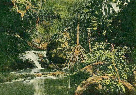
A jungle stream in the Valley of Fonte, Guam, 1910 |
|
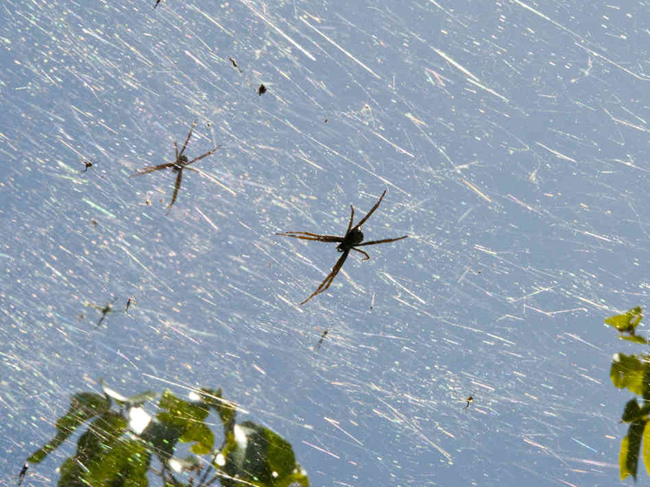
Invasive brown tree snakes have gobbled up most of Guam''s native forest birds. Without these avian predators to keep their numbers in check, the island''s spider population has exploded |
|
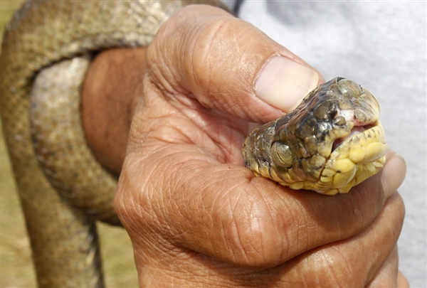
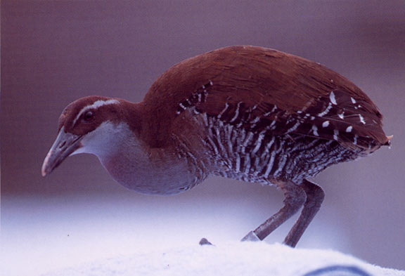
the Koko or Guam rail |
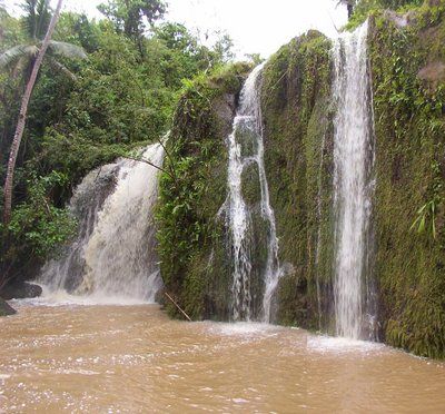
lower melolo falls |
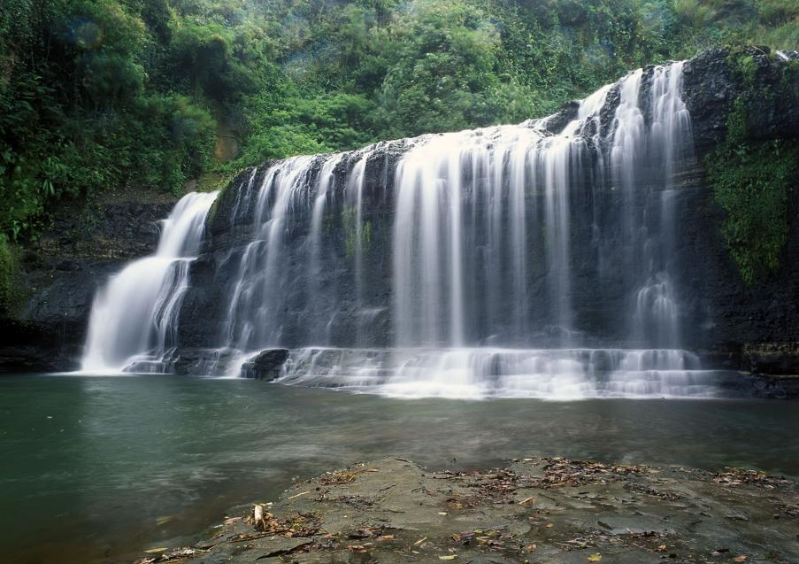
Talofofo Falls, Guam |
In the wet season, there are 40 times more spiders on Guam than there are on other nearby islands -http://www.futurity.org/top-stories/spiders-infest-guam-after-native-birds-disappear/ |
|
Tarague Embayment. Guam is a volcanic island that is located at the southern end of a chain of volcanic islands associated with the Izu-Bonin-Mariana Arc, which formed as a result of the subduction of the Pacific Plate underneath the Philippine Sea Plate (and also the tiny Mariana Plate). Associated with the Izu-Bonin-Mariana Arc is the Mariana Trench.. The volcanic islands of the Izu-Bonin-Mariana Arc formed as a result of volatiles being released from the subducting Pacific plate. These volatiles (mostly water and carbon dioxide) lowered the melting temperatures of the mantle underneath the arc, producing melts which created the volcanic islands.Guam was built from volcanic eruptions starting around 43 MA. The most recent volcanic eruption on Guam was around 10 MA. there has been time for carbonates (limestones) to form on top of some of the volcanics, and there are abundant coral reefs located offshore. One place where some impressive carbonate deposits have formed on Guam is Tarague Embayment. The rocks are a little hard to see since theyÆre covered under thick green vegetation. Underneath that vegetation, though, there is a limestone cliff that was formed in the Pliocene-Pleistocene (within the last 5 million years or so). |
Guam Tumon bay |
Agat Guam |
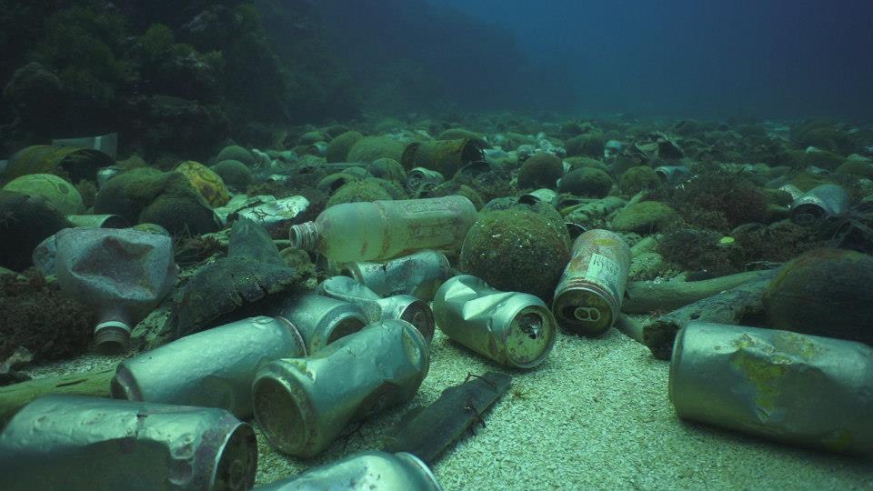
On a routine recreational dive off the coast of Agat, Guam, Mike McCue, curator for the UnderWater World aquarium in Guam, discovered a huge rubbish pile that had amassed across an area of 50 square metres. The rubbish field was the result of converging ocean currents that brought floating debris from around the island to the same resting place. It was an accumulated, significant and shocking reminder of the impact of human waste on the natural environment.Among the rubbish items were bowling balls, plastic bags, toys and containers, thousands of aluminium cans, and even a discarded mattress, waterlogged with 500 pounds of water, which had to be floated to the surface. http://shamengo.com/les-reseaux-sociaux-au-service-des-oceans/?/feed/&lang=en |
Rock formation on Tanguisson beach, Guam |
Orote Point Guam |
Two lovers, see fish Apogon guamensis (Guam) |
Sirena Beach Guam |
Tarague Beach |
|
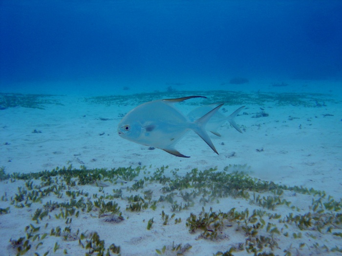
Trachinotus blochii, Guam |
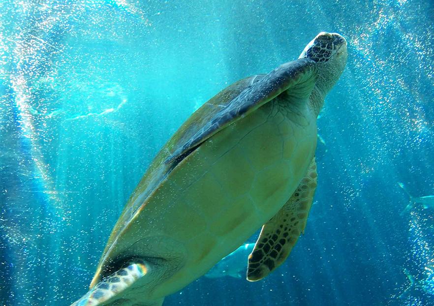
Guam Dive |
|
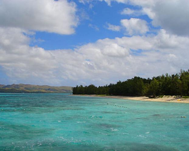
Cocos Island |
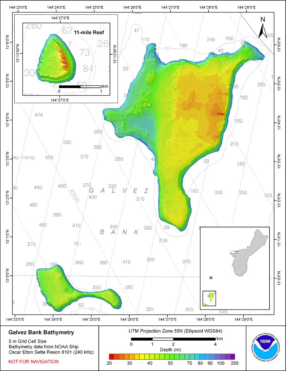
Galvez Bank is located about 12 nautical miles (22 km) south-southwest of the island of Guam. The bank actually consists of several bathymetric highs, with a minimum charted depth of 20 m. Most of the bank top is characterized by moderate relief, lots of algae, scattered corals and a few reef fish. The bank has a fair amount of coral cover in several areas and a moderate number of reef fish. http://www.soest.hawaii.edu/pibhmc/pibhmc_cnmi_gal.htm |
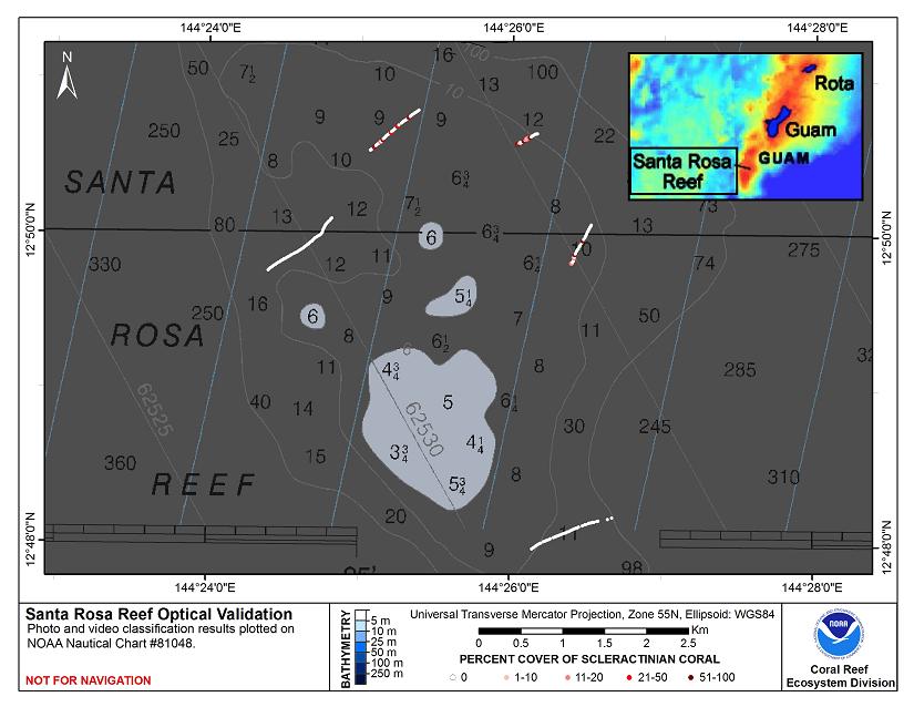
Santa Rosa Reef http://www.soest.hawaii.edu/pibhmc/pibhmc_cnmi_srr_optical.htm |


The Southern Mariana Islands, all similar in structure, are a part of the frontal arc of the Mariana arc-trench system and are dated as late Eocene to early Miocene (15-20 Ma). Though the southern islands are volcanic in origin, they are nearly all covered with uplifted limestone from ancient coral reefs; these episodically uplifted limestone terraces create a flat ōlayer-cakeö topography with numerous caves, both above and below sea level.
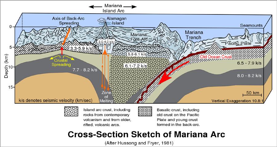
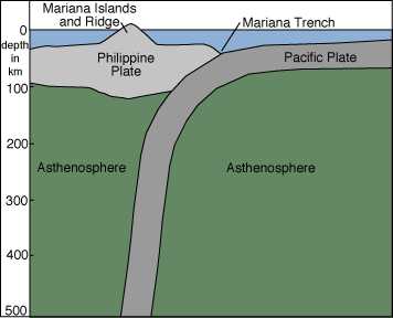
The Northern Mariana Islands are part of the Mariana Arc, where the Pacific plate is being subducted under the Philippine plate. The islands from Anatahan to Farallon de Pajaros are all stratovolcanoes (volcanoes composed of both lava flows and pyroclastic material) that result from the re-melting of subducted material.
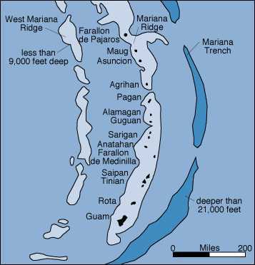
The West Mariana Ridge (WMR) is a remnant volcanic island arc that forms a series of seamounts, lying 145 to 170 km west of and parallel to the main island chains. The WMR is of intermediate age, being younger than the southern island arc and older than the northern island arc. Some of these seamounts rise to within 13 m of the surface. The absence of terrestrially-derived sediments, recent volcanic ash, and infrequent direct anthropogenic impact at the WMR contribute to the near-optimal conditions for coral growth. Accordingly, some of the shallower structures feature well-developed reef ecosystems, with lush gardens of stony corals
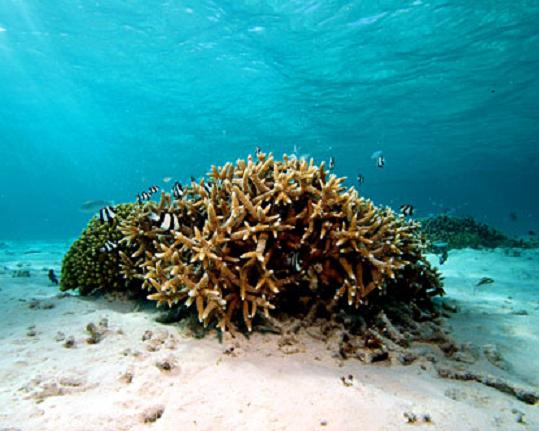
The southern islands have the oldest and most developed reefs in the Mariana Islands. The reefs are generally most developed on the western (leeward) sides of the islands. The geologically younger northern islands are primarily made up of very recent (4,000 year old) volcanic materials. The extent of reefs around these islands is varied. In general, the younger islands have sparse, low diversity coral reef communities. Around only a few of the northern banks and islands (e.g. Maug, Guguan, Stingray Shoals), diverse coral communities with as many as 60 coral species have been observed.
C http://www.soest.hawaii.edu/pibhmc/pibhmc_cnmi.htm
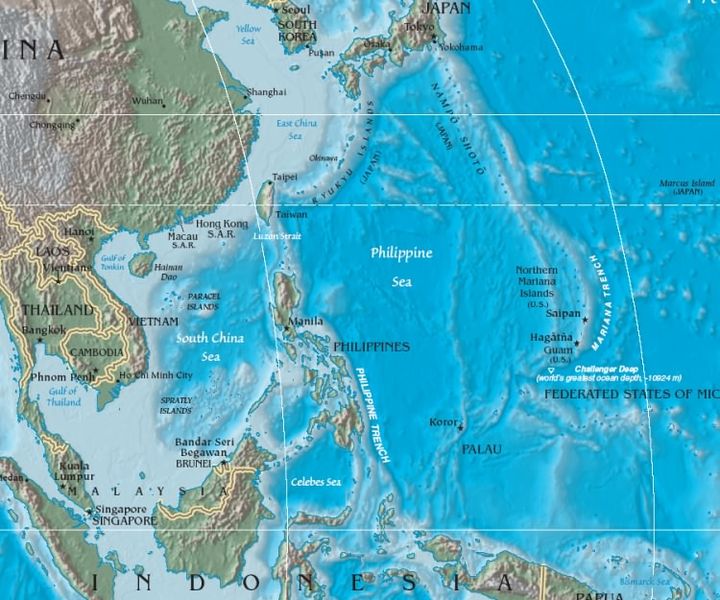
The islands are part of a geologic structure known as the Izu-Bonin-Mariana Arc system, and range in age from 5 MY in the north to 30 MY in the south (Guam). The island chain arises as a result of the western edge of the Pacific Plate moving westward and plunging downward below the Mariana plate, a region which is the most volcanically active convergent plate boundary on Earth. This subduction region, just east of the island chain, forms the noted Mariana Trench, the deepest part of the Earth''''s oceans and lowest part of the surface of the Earth''''s crust. In this region, according to geologic theory, water trapped in the extensive faulting of the Pacific Plate as serpentinite, is heated by the higher temperatures of depth during its subduction, and the pressure from the expanding steam results in the hydrothermal activity in the area, and the volcanic activity which formed the Mariana Islands. http://en.wikipedia.org/wiki/Mariana_Islands
http://www.soest.hawaii.edu/pibhmc/pibhmc_cnmi.htm
http://www.marianasgrazingacademy.org/PDF''''s/Soils/soils_tinian_2010_notes.pdf soil
See all http://plate-tectonic.narod.ru/marianaphotoalbum.html
north Mariana arc
Submarine ring of Fire
Mariana Islands ecosystem
Volcanoes of Mariana Islands
maps