 | Martian surface morphology (water,rivers, erosion,atmosphere, impact craters - text only on English) |
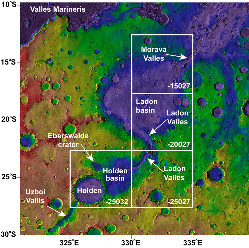
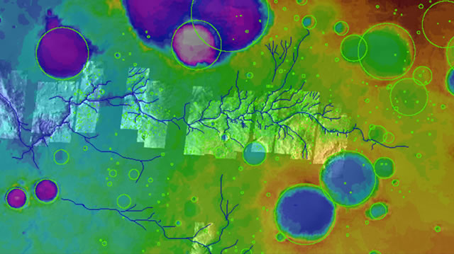
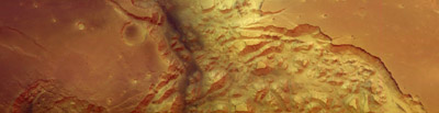
Topography in southwest Margaritifer Terra with major features labeled; outlines show quadrangles mapped by Grant and others - http://www.nasm.si.edu/research/ceps/research/mars/geologic_mapping.cfm |
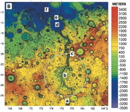
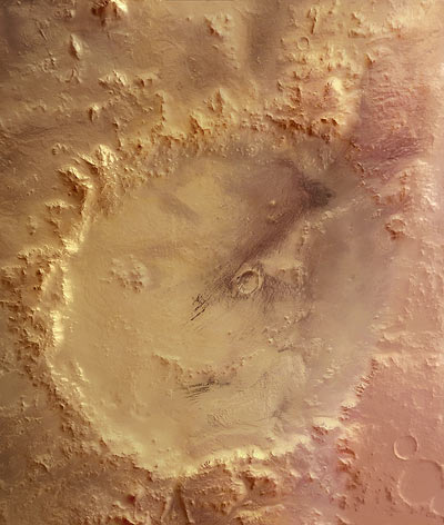
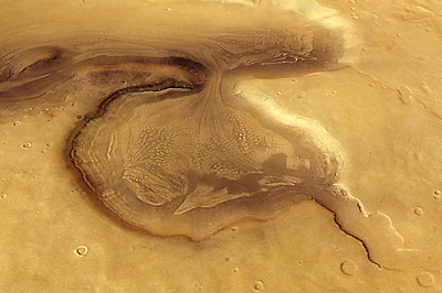
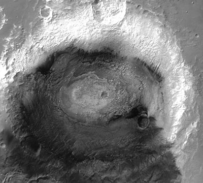
The presence of standing bodies of water on the Martian surface would tell us a great deal about the past climate. Lakes, more so than river channels, requires a warmer climate with either a ground water or precipitation recharge system, and they may represents formerly habitable sites. Topography of Ma''adim Vallis, showing the Ma''adim basin rim crosscut at (c) and at the valley head (a), dissected basin floor (b), Gusev crater (d), its exit breach (e), and undissected lowlands (f). Figure is MOLA topography with 100-m interval, cylindrical projection -http://www.nasm.si.edu/research/ceps/research/mars/paleolakes.cfm |
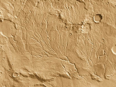
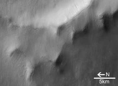
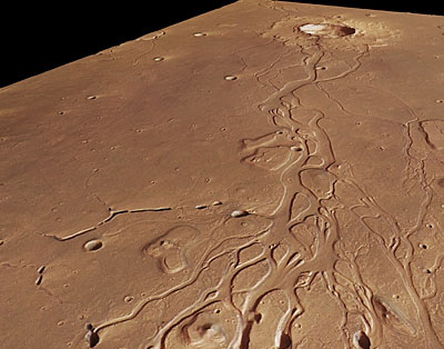
The ancient Noachian impact craters on Mars so deeply eroded while the contemporary river valley networks remain poorly developed .Naktong Vallis is an example of a Martian valley network with features consistent of a brief, late-stage epoch of surface runoff.In addition to the intense crater degradation occurred during the Noachian Period, a late stage of valley network activity occurred between the Lake Noachian and Early Hesperian Epochs, about 3700MA. The immature fluvial features briefly preserved on Mars are remnants of this brief late stage -http://www.nasm.si.edu/research/ceps/research/mars/fluvial_processes.cfm |
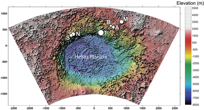
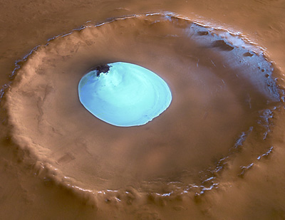
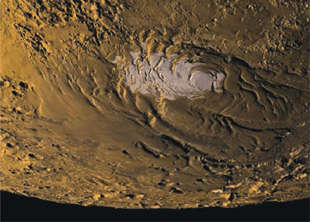
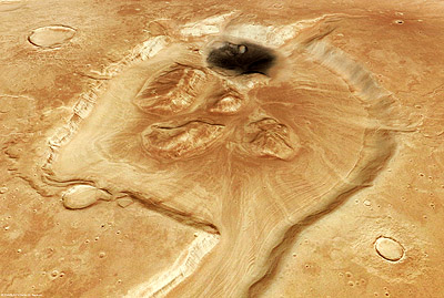
Mars today is cold and dry and liquid water is not stable at the surface. There are several landforms that suggest the climate on Mars was once warmer and wetter - similar to Earth. Scientists have been intrigued by the discovery of layered deposits on Mars since they were recognized by Mariner 9 and Viking orbiters in the 1970s. Many of the layered deposits on Mars are light-toned, occur in crater interiors, and are characterized by thick, laterally continuous, repetitive sequences. There are many ways in which layered deposits can form on Mars, including volcanic, wind or water-related processes. The physical and chemical nature of the light-toned layered deposits in Terby crater and other craters around the great Hellas impact basin are consistent with deposition of material in a large, standing body of water much earlier in its history. Many craters around the 2,300 km-wide (1,430 mi) Hellas basin, marked with black and white circles, contain interior layered deposits including craters Terby ("T"), Millochau ("M") [Mest and Crown, Icarus, 2005], "A" and "B" [Korteniemi et al., JGR, 2005], Niesten ("N") and the informally named SW crater ("S") [From Wilson et al., 2007]- http://www.nasm.si.edu/research/ceps/research/mars/crater_terby.cfm |
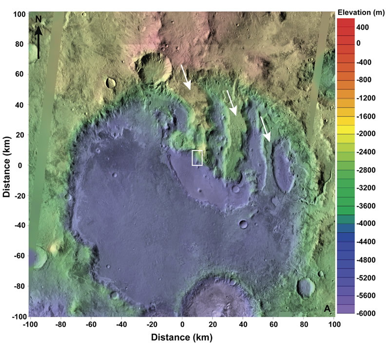
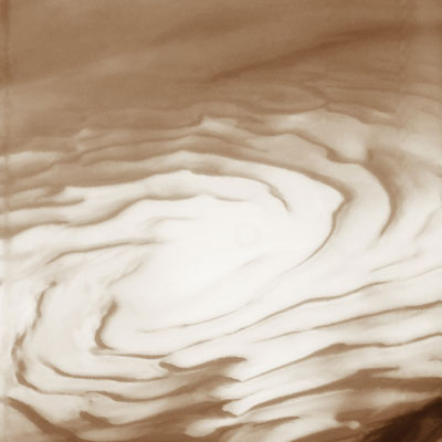
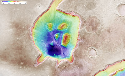
One of the most spectacular exposures of light-toned layers on Mars occurs in Terby, a large, ancient crater located along the northern rim of Hellas basin in the Martian southern highlands. Over 2 km-thick sequences of light-toned layered deposits are exposed in benches (long, nearly planar surfaces dropping off steeply on one or both sides) that extend from the northern crater wall to the center of the crater. The layers within the benches in Terby are fine-grained, partially indurated (cemented), range in thickness from less than 1 m up to about 10 m and contain hydrated minerals such as phyllosilicates (clay-bearing minerals found on Earth that are associated with water-rich environments). Other craters around Hellas, such as Niesten and "SW" craters, have comparable layered sequences banked along their northern rims at similar elevations, suggesting a similar age and origin. Through the topographic (elevation), geomorphic (surface texture) and stratigraphic (layer sequence) analyses, we studied the origin of the landforms in Terby and its long geologic history/ - Mars Orbiter Laser Altimeter (MOLA) topography (elevation) of Terby crater. White arrows indicate benches that expose ~2 km thick sequences of layers; the benches extend from the northern rim and terminate in a deep, moat-like depression in the center of the crater (modified from Wilson et al., 2007- http://www.nasm.si.edu/research/ceps/research/mars/crater_terby.cfm |
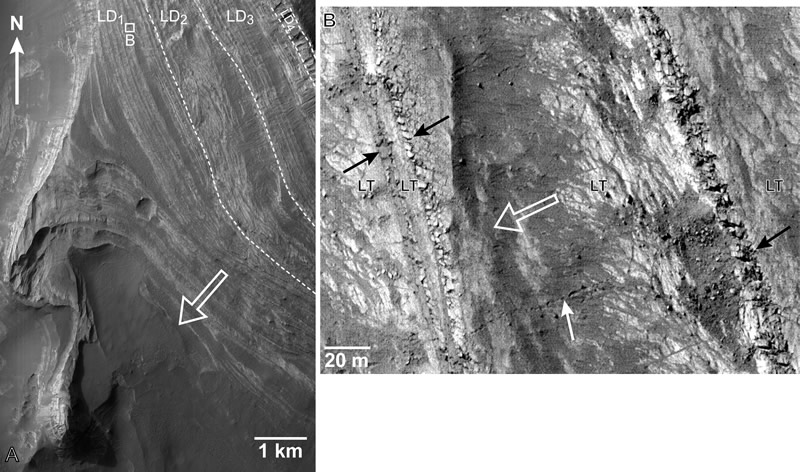
(A) Layered sequence in the western bench (see Figure 2 for context) are2.5-km-thick, dashed lines show contacts between sub-units (LD1 ¢ LD4).Hollow white arrow points downslope. HiRISE image 1662¢1520. (B) Detail of lowest unit, LD1 in the western bench is characterized by thicker, light-toned (LT) beds interbedded with thin, intermediate-toned layers (black arrows) that are weathering along meter-spaced joints to produce boulders. The boulders accumulate on the slopes and their downslope movement is often recorded by boulder tracks that can be over 1 km long (e.g., white arrow). Although the LT beds are typically heavily mantled, there are hints of finer layers or laminations at HiRISE resolution (28 cm/pixel). Hollow arrow points downslope. Modified from Wilson et al., 2007. |
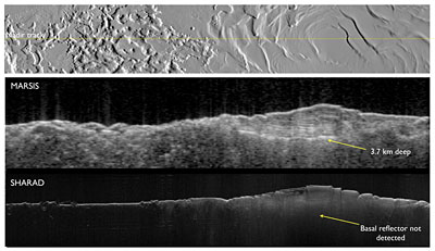
South polar layered deposit (SPLD) on Mars. The Mars Express radar experiment, MARSIS, was designed to penetrate deep and it has delivered on its promise. The above figure shows the base of the SPLD at the deepest recorded point of 3.7 km. In contrast, The Shallow Subsurface Radar (SHARAD) on NASAÆs Mars Reconnaissance Orbiter designed as a high-resolution radar for a maximum penetration of 1 km has difficulty detecting the SPLD base. The two complementary instruments work together to discover hidden martian secrets -http://www.esa.int/esa-mmg/mmg.pl?b=b&type=I&mission=Mars%20Express&single=y&start=256&size=b |
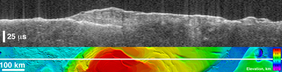
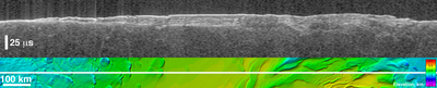
Bright lower echo from MarsÆ south-polar layered deposits. The upper image of this composite is a æradargramÆ from the Mars Advanced Radar for Subsurface and Ionospheric Sounding (MARSIS) on board ESAÆs Mars Express. It shows data from the subsurface of Mars in the water-ice-rich layered deposits that surround the south pole of the planet. The lower image shows the position of the ground track of the spacecraft (indicated by a white line) on a topographic map of the area based on data from the MOLA laser altimeter on board NASA''s Mars Global Surveyor. The images are 1250 kilometers wide. The MARSIS radar echo trace splits into two traces on the left side of the image, at the point where the ground track crosses from the surrounding plains onto elevated layered deposits. The upper trace is the echo from the surface of the deposits, while the lower trace is interpreted to be the boundary between the lower surface of the deposits and the underlying material. The strength of the lower echo suggests that the intervening material is nearly pure water ice. Near the image center, the bright lower echo abruptly disappears for unknown reasons. The time delay between the two echoes reaches a maximum of 42 microseconds left of center, corresponding to a thickness of 3.5 kilometres of ice. The total elevation difference shown in the topographic map is about 4 kilometres between the lowest surface (purple) and the highest (red). http://www.esa.int/esa-mmg/mmg.pl?b=b&type=I&mission=Mars%20Express&single=y&start=324&size=b |
Virtual æsliceÆ through icy layered deposits near Mars'' south pole. The upper image of this composite is a æradargramÆ from the Mars Advanced Radar for Subsurface and Ionospheric Sounding (MARSIS) on board ESAÆs Mars Express. It shows data from the subsurface of Mars in the ice-rich layered deposits that surround the south pole. The lower image shows the position of ground track of the spacecraft (indicated by a white line) on a topographic map of the area based on data from the MOLA laser altimeter on board NASA''s Mars Global Surveyor. The images are 1580 kilometers wide. The MARSIS radar echo trace splits into two traces near the left edge of the image, at the point where the ground track crosses from the surrounding plains onto the elevated layered deposits. The upper trace is the echo from the surface of the deposits, while the lower trace is interpreted to be the boundary between the lower surface of the deposits and the underlying material. The strength of the lower echo suggests that the intervening material is nearly pure water ice. Near the image center, several bright bands between the echo traces are likely caused by interaction of the radar waves with internal layers of the deposits. The time delay between the upper and lower traces in the banded area is 20 microseconds, corresponding to a thickness of 1.6 kilometres of ice. The total elevation difference shown in the topographic map is about 3 kilometres between the lowest surface (dark blue) and the highest (yellow). http://www.esa.int/esa-mmg/mmg.pl?b=b&type=I&mission=Mars%20Express&single=y&start=325&size=b |
Thickness of Mars'' South Polar Layered Deposits. This map shows the thickness of the south polar layered deposits of Mars, an ice-rich geologic unit that was probed by the Mars Advanced Radar for Subsurface and Ionospheric Sounding (MARSIS) on board ESAÆs Mars Express.The thickness of the layered deposits was determined by measuring the time delay between radar echoes from the surface and those from the lower boundary, or æbedÆ, of the deposits. The radar data indicate that the deposit, larger than than a big portion of Europe in area, is more than 3.7 kilometres thick in places, and that the material consists of nearly pure water ice with only a small component of dust. The map was generated by comparing the elevation of the bed as determined by MARSIS with the high-resolution map of surface topography obtained by the Mars Orbiter Laser Altimeter (MOLA) aboard NASAÆs Mars Global Surveyor. The thickness of the layered deposits is shown by colors, with purple representing the thinnest areas, and red the thickest. The total volume of ice in the layered deposits is equivalent to a water layer 11 metres deep, if spread evenly across the planet. The boundary of the layered deposits was mapped by scientists from the U.S. Geological Survey. The dark circle in the upper center is the area pole-ward of 87 ░ south latitude, where MARSIS data cannot be collected. The map covers an area 1670 by 1800 kilometres. http://www.esa.int/esa-mmg/mmg.pl?b=b&type=I&mission=Mars%20Express&single=y&start=326&size=b |
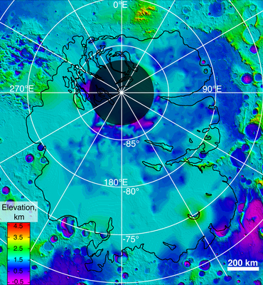
Lower boundary of icy layers covering Mars'' south-polar region This map shows the topography of the south polar region of Mars, including topography buried by thick deposits of icy material. The map is a combination of subsurface elevation data acquired by the Mars Advanced Radar for Subsurface and Ionospheric Sounding (MARSIS) aboard the European Space AgencyÆs Mars Express orbiter and surface elevation data acquired by the Mars Orbiter Laser Altimeter aboard NASAÆs Mars Global Surveyor orbiter. The black line shows the boundary of the south polar layered deposits, an ice-rich geologic unit that was probed by MARSIS. Elevation values within the black outline, as measured by MARSIS, show the topography at the boundary between the layered deposits and the underlying material, an interface known as the æbedÆ of the deposits. The elevation of the terrain is shown by colors, with purple and blue representing the lowest areas, and orange and red the highest. The total range of elevation shown is about 5 kilometres. The radar data reveal previously undetected features of topography of the bed, including depressions as deep as 1 kilometre shown in purple in the near-polar region. The boundary of the layered deposits was mapped by scientists from the U.S. Geological Survey. The dark circle in the upper center is the area pole-ward of 87 ░ south latitude, where MARSIS data cannot be collected. The map covers an area 1670 by 1800 kilometres. http://www.esa.int/esa-mmg/mmg.pl?b=b&type=I&mission=Mars%20Express&single=y&start=327&size=b |
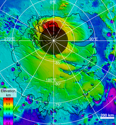
Upper surface of icy layers covering Mars'' south-polar region. This map shows the topography of the south polar region of Mars. The data were collected by the Mars Orbiter Laser Altimeter (MOLA) aboard NASAÆs Mars Global Surveyor orbiter between 1997 and 2001.The elevation of the terrain is shown by colors, with purple and blue representing the lowest areas, and orange and red the highest. The total range of elevation shown is about 5 kilometres. The black line shows the boundary of the south polar layered deposits, an ice-rich geologic unit that was probed by the Mars Advanced Radar for Subsurface and Ionospheric Sounding (MARSIS) aboard the European Space Agency''s Mars Express orbiter between 2005 and 2006. The radar data indicate that the deposit is more than 3.7 kilometres thick in places, and that the material consists of nearly pure water ice, with only a small component of dust. The MARSIS team also determined that the total volume of ice in the layered deposits is equivalent to a water layer 11 metres deep, if spread evenly across the planet. The boundary of the layered deposits was mapped by scientists from the U.S. Geological Survey. The dark circle in the upper center is the area pole-ward of 87 ░ south latitude, where MARSIS data cannot be collected. The image covers an area 1670 by 1800 kilometres. http://www.esa.int/esa-mmg/mmg.pl?b=b&type=I&mission=Mars%20Express&single=y&start=328&size=b |
This mosaic image was built from ten observations by the OMEGA Visible and Infrared Mineralogical Mapping Spectrometer on board ESAÆs Mars Express, when the spacecraft was flying at about 6000 kilometres altitude over the south pole during the Martian early to mid-Spring.The dark region within the bright seasonal cap below and to the right of the pole is the so-called æcryptic regionÆ on Mars. During Southern spring, this area æmysteriouslyÆ become much darker than the rest of the seasonal ice cap, notwithstanding temperatures as low as -135є C which should correspond to the presence of bright carbon dioxide ice, or ædry iceÆ, on the surface. The colour scheme in this area indicates the presence of carbon dioxide ice in reddish tones, and the presence of water ice in bluish tones.OMEGA observations have revealed that there is a thick slab of dry ice in this area, but its surface is heavily covered by dust. Such dust contamination may result from the sunlight passing through the clear ice and heating the soil underneath. This would cause pressure to build up in carbon dioxide bubbles below the ice until a geyser erupts throwing dust onto the surface.The letters indicate regions with different surface compositions and texture (a: bright, fine-grained ōdry iceö; b: larger grained ōdry iceö which is not quite as bright; c: water ice frost; d: cryptic region). The greyish tones in the cryptic region indicate that the surface is heavily contaminated by dust. http://www.esa.int/esa-mmg/mmg.pl?b=b&type=I&mission=Mars%20Express&single=y&start=341&size=b |
Mars northern polar features.The polar ice deposits follow the seasonal cycles. The cap is covered by frozen water and carbon dioxide ice in winter and spring but by this point in the martian year all of the carbon dioxide ice has warmed and evaporated into the planetÆs atmosphere. Only water ice is left behind, which shows up as bright white areas in this picture. From these layers, large bursts of water vapour are occasionally released into the atmosphere. In winter, part of the atmosphere recondenses as frost and snow on the northern cap. These seasonal deposits can extend as far south as 45░N latitude and be up to a metre thick. Another phenomenon occurs on the curved scarps of the northern polar cap, such as the Rupes Tenuis slope (on the left of this image). During spring, the seasonal carbon dioxide layer is covered by water frost. At ertain times, winds remove the the millimetre-thick top layer of frozen water, revealing the carbon dioxide ice below. These processes bear witness to a dynamic water cycle on Mars and may lead to the varying ccumulation of water ice over the polar cap -http://www.esa.int/esa-mmg/mmg.pl?b=b&type=I&mission=Mars%20Express&single=y&start=34&size=b. |
Springtime at MarsÆ south pole. Buried ice deposits in the south polar region of Mars, close to Ulyxis Rupes at about 72░S/162░E.- http://www.esa.int/esa-mmg/mmg.pl?b=b&type=I&mission=Mars%20Express&start=4 |
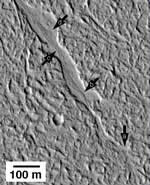
Evidence that pulses of water have redistributed sediments on Mars. Arrows show features within a graben (fault-bounded linear valley) that are similar in scale and pattern to features observed in central Australia (by Mary Bourke, University of Oxford and CEPS) that were produced by infrequent massive flood events. (Portion of Mars Orbiter Camera image M04-04068, 20.1░N, 157.1░W, courtesy Malin Space Science Systems/Jet Propulsion Laboratory/NASA) - http://www.nasm.si.edu/research/ceps/research/mars/mars.cfm |
A valley network system in Arabia Terrathe, oldest and most long-lived fluvial systems on Mars-http://www.nasm.si.edu/research/ceps/research/mars/craddock_mvn.cfm |
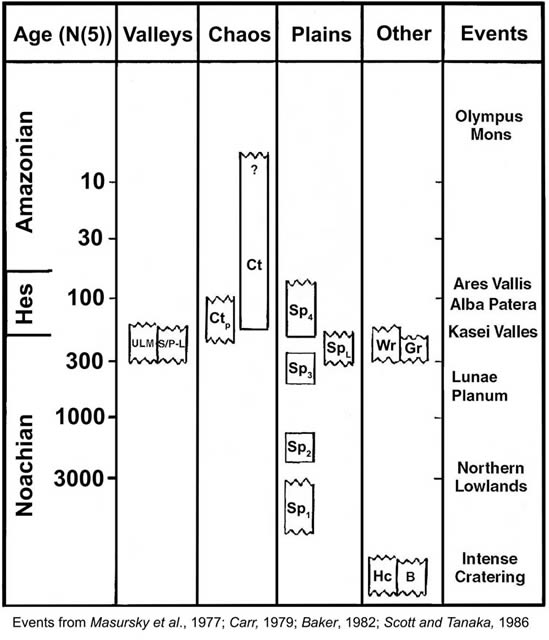
Timeline indicating the relative age of events shaping the surface in the Margaritifer Terra region and placed within the context of larger-scale planet-wide evidence -http://www.nasm.si.edu/research/ceps/research/mars/water_systems.cfm |
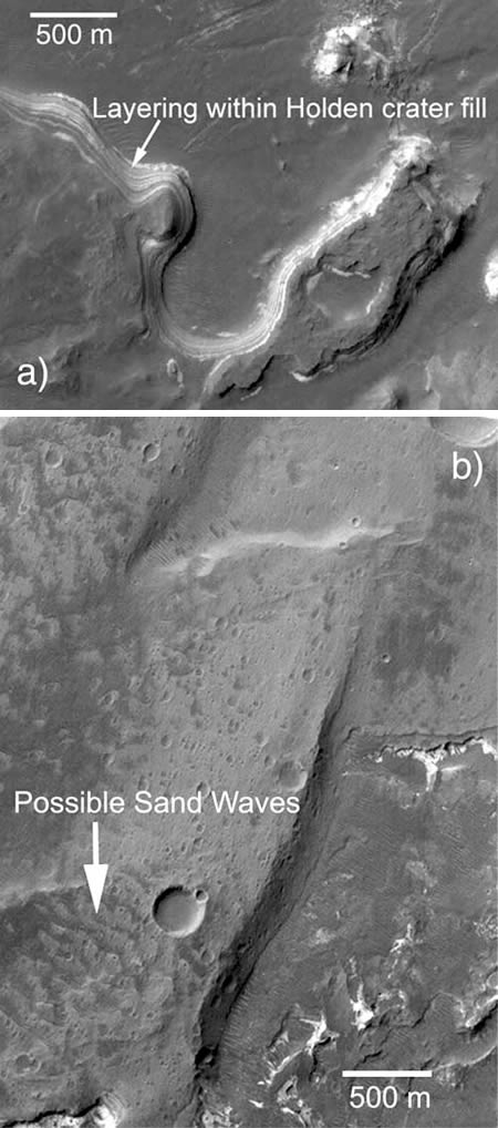
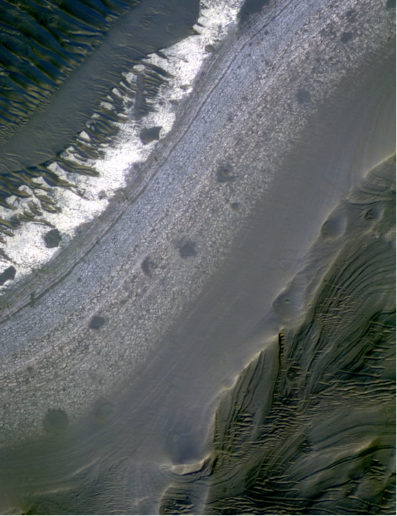
(a) Layering in ancient lake sediments on the floor of Holden Crater. The layers are thin and continuous over distances of up to kilometers, consistent with emplacement in standing water. (b) Large bed forms were deposited where alluvium was washed into the crater as water impounded in Uzboi Vallis breached Holden''s rim. Both images are subsets of MOC image M0302733, centered at 27.1░ S, 34.9░W and 2.8 m/pixel resolution - http://www.nasm.si.edu/research/ceps/research/mars/holden_crater.jpg |
Fine scale beds exposed on the floor of Holden crater were likely deposited in an ancient lake. Persistence of such a lake points to conditions that would have been much more clement that currently are found on Mars and may point to habitable conditions early on in the planet''s history. Portion of HiRISE image PSP_003077_1530_IRB showing eroded alluvial fan materials overlying phyllosilicate bearing, probable lacustrine deposits in Holden crater, Mars. False color created using data from the RED (image scale of 26 cm/pixel), http://www.nasm.si.edu/research/ceps/research/mars/holden_crater.jpg |
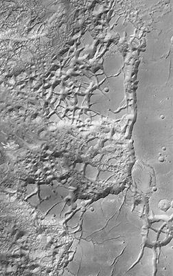
The HRSC obtained this image during orbit 456 with a resolution of approximately 25 metres per pixel. The scene shows an area located at about 3є South and 335є East. Aureum Chaos is located in the eastern part of Valles Marineris, south-west of the 280 kilometre-wide impact crater Aram Chaos. This is an example of the chaotic terrain contained in this part of the Valles Marineris http://www.esa.int/esa-mmg/mmg.pl?b=b&type=I&mission=Mars%20Express&single=y&start=492&size=b |
The location is on the Martian equator north of Valles Marineris between 1░ South to 2.5░ North and 323░ East. The area is 50 km across and shows mesas and cliffs as well as flow features indicating erosion by the action of flowing water. In this landscape view North is on the right http://www.esa.int/esa-mmg/mmg.pl?b=b&type=I&mission=Mars%20Express&single=y&start=641&size=b |
a) Portion of THEMIS VIX image V08198017 (18m/pixel) showing a typical example of a wrinkle ridge observed along the "shorelines" in Isidis Planitia. (b) Portion of THEMIS Vis image V02431006 (72 m/pixel) showing the only example of ridges observed at the THEMIS VIS scale along the "shorelines" within Isidis Planitia, nor immediately dismissed as wrinkle-ridges or Aeolian landforms-http://www.nasm.si.edu/research/ceps/research/mars/martian_shorelines.cfm |
This HRSC image shows the Northern main channel of Kasei Valles, which probably has been formed by gigantic flood events.http://www.esa.int/esa-mmg/mmg.pl?b=b&type=I&mission=Mars%20Express&single=y&start=343&size=b |
Nanedi Valles, a roughly 800-kilometre valley extending southwest-northeast and lying in the region of Xanthe Terra, southwest of Chryse Planitia. In this view, Nanedi Valles ranges from approximately 0.8- to 5.0-kilometre wide and extends to a maximum of about 500 metres below the surrounding plains. This valley is relatively flat-floored and steep-sloped, and exhibits meanders and a merging of two branches in the north. The valley''s origins remain unclear, with scientists debating whether erosion caused by ground-water outflow, flow of liquid beneath an ice cover or collapse of the surface in association with liquid flow is responsible.http://www.esa.int/esa-mmg/mmg.pl?b=b&type=I&mission=Mars%20Express&single=y&start=389&size=b |
Valley networks, like these photographed by NASAÆs Viking mission, suggest that rivers once flowed on Marshttp://www.esa.int/esa-mmg/mmg.pl?b=b&type=I&mission=Mars%20Express&single=y&start=680&size=b |
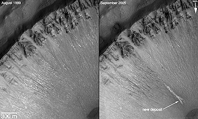
The discovery of bright deposits on Mars, announced on 7 December 2006 by NASA, could indicate that liquid water has recently flowed on a few locations on the planet. The newly discovered deposits were identified by comparing different images of the same area taken by NASAÆs Mars Global Surveyor (MOC camera), over a period of few years. The images suggest that water may have flowed there sometime within the past seven years http://www.esa.int/esa-mmg/mmg.pl?b=b&type=I&mission=Mars%20Express&single=y&start=340&size=b |
ArtistÆs impression of water under the martian surface. If underground aquifers like that really do exist, Mars Express has a good chance of finding them. The implications for human exploration and eventual colonisation of the red planet would be far-reachinghttp://www.esa.int/esa-mmg/mmg.pl?b=b&type=I&mission=Mars%20Express&single=y&start=687&size=b |
Arabia Terra is one of the three equatorial regions where the PFS instrument detected both water vapour and methane concentration. The other two areas are Elysium Planum and Arcadia Memnonia.http://www.esa.int/esa-mmg/mmg.pl?b=b&type=I&mission=Mars%20Express&single=y&start=560&size=b |
This HRSC image provides a perspective view of residual water ice on the floor of Vastitas Borealis Crater on Mars. The image is centred at 70.17; North latitude and 103.21 East longitude http://www.esa.int/esa-mmg/mmg.pl?b=b&type=I&mission=Mars%20Express&single=y&start=344&size=b http://www.membrana.ru/particle/11243 |
This image, obtained by the HRSC on ESA''s Mars Express, is a mosaic of overlapping images gathered during five separate orbits. The ground resolution ranges between 10-20 metres per pixel, depending on location within the image strip, and the crater is shown lying near 51░ South and 329░East. North is up.The image shows Crater Galle containing a large stack of layered sediments forming an outcrop in the southern part of the crater. Several parallel gullies, possible evidence for liquid water on the Martian surface, originate at the inner crater walls of the southern rim http://www.esa.int/esa-mmg/mmg.pl?b=b&type=I&mission=Mars%20Express&start=33 |
The image shows several parallel gullies, possible evidence for liquid water on the Martian surface, which originate at the inner crater walls of the southern rim.http://www.esa.int/esa-mmg/mmg.pl?b=b&type=I&mission=Mars%20Express&single=y&start=394&size=b |
This HRSC image shows a perspective view of a possible dust-covered frozen sea near the Martian equator.The image is centred at 5.46є North latitude and 150.30є East longitude. http://www.esa.int/esa-mmg/mmg.pl?b=b&type=I&mission=Mars%20Express&single=y&start=345&size=b |
Density of Mars'' South Polar Layered Deposits. MOLA shaded relief mosaic combined with color from Mars Global Surveyor imaging of Mars'' south polar region showing the residual ice cap (in white) within the smooth SPLD that overlie the cratered southern highlands. [Photo credit: NASA/MOLA Science Team] - http://www.sciencemag.org/content/317/5845/1718.full |
Frozen water and carbon dioxide over Martian poles.Water may once have flowed freely on Mars and, like the Earth, the planet receives sunlight and has its own internal energy source. So the odds on primitive life thriving for at least some time during the planetÆs history are reasonably good.http://www.esa.int/esa-mmg/mmg.pl?b=b&type=I&mission=Mars%20Express&single=y&start=685&size=b |
Young glacial feature.This image is taken by the High Resolution Stereo Camera (HRSC) on board ESA''s Mars Express, shows a perspective view of a glacial feature located in Deuteronilus Mensae.The image is centred at a 37.92░ North latitude and 24.61░ East longitude.http://www.esa.int/esa-mmg/mmg.pl?b=b&type=I&mission=Mars%20Express&single=y&start=711&size=b http://www.membrana.ru/particle/12206 |
This image shows the Deuteronilus Mensae region on Mars, an area primarily characterized by glacial features. It was taken on 14 March 2005 (orbit number 1483) by the High Resolution Stereo Camera (HRSC) onboard ESAÆs Mars Express with a ground resolution of approximately 29 metres per pixel. The area is located on the northern edge of Arabia Terra and borders the southern high- and northern lowlands, at approximately 39░ North and 23░ East. http://www.esa.int/esa-mmg/mmg.pl?b=b&type=I&mission=Mars%20Express&start=27 |
This image shows a perspective view of the Deuteronilus Mensae region on Mars. It was taken on 14 March 2005 by the High-Resolution Stereo Camera (HRSC) onboard ESAÆs Mars Express with a ground resolution of approximately 29 metres per pixel. It is believed that the valleys visible in the image may have originated from intense flooding by melted water ice. The water then froze rather quickly and flowed down the slopes of the depression like a glacier. http://www.esa.int/esa-mmg/mmg.pl?b=b&type=I&mission=Mars%20Express&single=y&start=320&size=b |
This colour image shows the Northern branch of Kasei Valles and the plain Sacra Mensa. The image has been rotated 90 degrees clockwise so North is to the right. An oval structure at the western edge (top) of the scene is interpreted to be a crater caused by an oblique meteorite impact.http://www.esa.int/esa-mmg/mmg.pl?b=b&type=I&mission=Mars%20Express&start=30 |
This image, taken by the High Resolution Stereo Camera (HRSC) on board ESA''s Mars Express spacecraft, shows the region of Kasei Valles, one of the biggest outflow channel systems on Mars. The HRSC obtained this image during orbit 1429 on 26 February 2005, at a ground resolution of approximately 29 metres per pixel. The image shows a perspective view of the Northern branch of Kasei Valles looking to the West (the image has been rotated approximately 90 degrees clockwise so that North is to the right). As one of the biggest outflow channel systems on Mars, Kasei Valles was probably formed by gigantic flood events and later additionally shaped by glacial activity. http://www.esa.int/esa-mmg/mmg.pl?b=b&type=I&mission=Mars%20Express&single=y&start=356&size=b |
The image shows a perspective view of the Northern branch of Kasei Valles looking to the East (the image has been rotated approximately 90 degrees counter-clockwise so that North is to the left). |
This image, taken by the High Resolution Stereo Camera (HRSC) on board ESA''s Mars Express spacecraft, shows the regions of Granicus Valles and Tinjar Valles, which may have been formed partly through the action of subsurface water, due to a process known as sapping. The HRSC obtained these images on 14 February 2005 during orbit 1383 at a ground resolution of approximately 23.7 metres per pixel. The images have been rotated 90 degrees counter-clockwise, so that North is to the left. Both channel systems evolve from a single main channel entering the image scene from southeast (upper right), exhibiting an approximate width of 3 km and extending 300 m below the surrounding terrain at maximum.http://www.esa.int/esa-mmg/mmg.pl?b=b&type=I&mission=Mars%20Express&single=y&start=364&size=b |
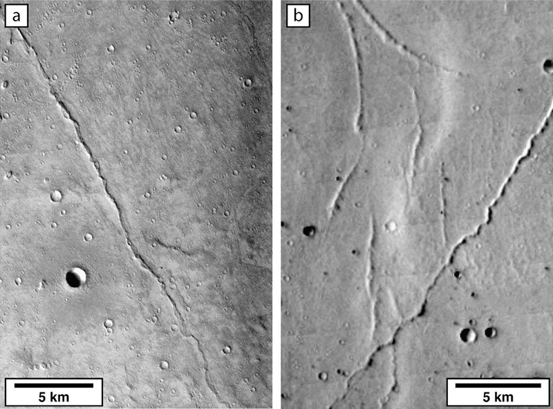
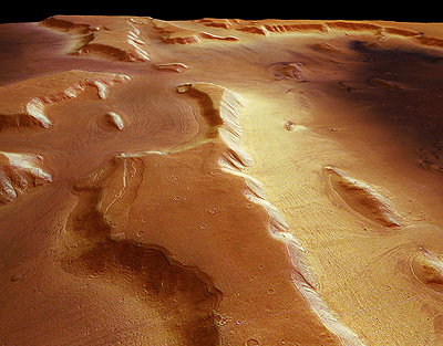
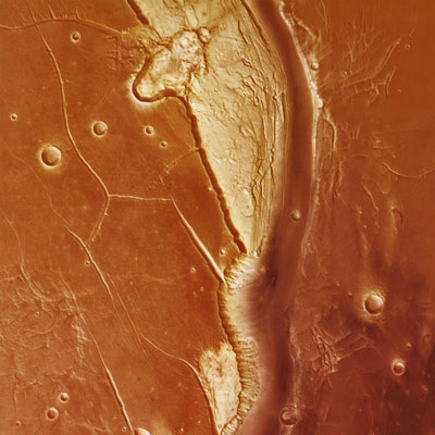
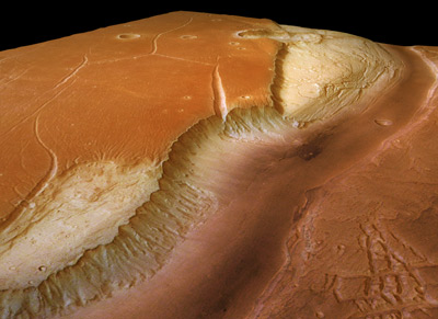
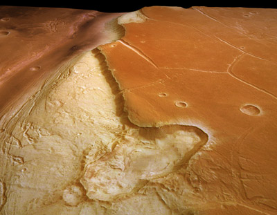
The crustal dichotomy boundary on Mars is a narrow region separating the cratered highlands, located mostly in the southern hemisphere of Mars, from the northern hemisphere''s lowland plains. The cratered highlands stand two to five kilometers higher than the lowland plains, so the boundary is a relatively steep slope. The processes that created and modified the dichotomy boundary remain among the major unanswered issues in Mars science. Our research includes studies of tectonics (folding and faulting) and erosion along the boundary, with a goal of better understanding how the dichotomy boundary formed and evolved with time. The highland crust along the boundary appears to have been flexed downward early in Martian history, perhaps due to emplacing a heavy load of volcanic materials in the lowlands. After the crustal boundary formed, sediment was trapped at the base of the slope, and later erosion of this sedimentary deposit formed the fretted terrain that is unique to Mars. |
This image, taken by the High Resolution Stereo Camera (HRSC) on board ESAÆs Mars Express spacecraft, shows a detail of the Medusa Fossae formation. The Amazonis Sulci, with its ridges and grooves, appears to be wind-sculpted. The lack of craters superposing this surface indicates that wind erosion has been the latest stage of eroding processes acting here.The HRSC obtained this image during orbit 917 with a resolution of approximately 13 metres per pixel. It shows an area located at about 5║ South and 213║ East http://www.esa.int/esa-mmg/mmg.pl?b=b&type=I&mission=Mars%20Express&single=y&start=531&size=b |
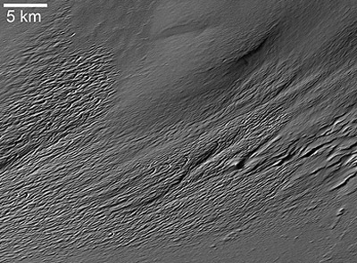
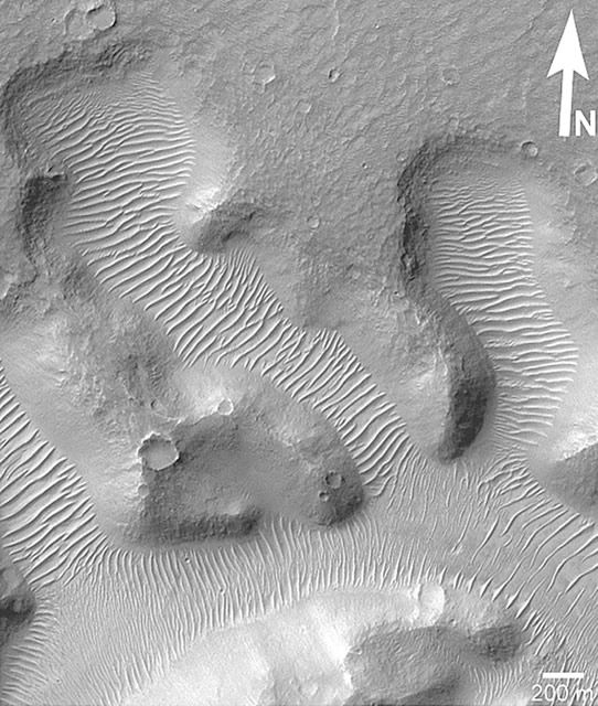
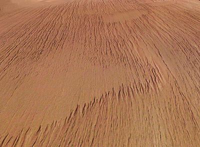
More than on Earth, wind plays a dominant process in modifying the surface of Mars. A variety of wind-generated features imaged on Mars speaks to the differences between the sister planets; not only is wind more prevalent on Mars, but also wind produces distincive features, such as traverse aeolian ridges (TARs), on Mars. A systematic study of TARs (Figure 1) revealed insight into these enigmatic landforms. Most TARs are located within +/- 50░ latitude at elevations ranging from -5 km to 3 km, with particularly high frequency between -1 km to 0 km1. Additionally, these ridges often occur in association with the Channel System Materials and the Olymnpus Mons Aureole1. Further insight into their latitude-dependent nature and key physical attributes has expanded our knowledge of TARs immensely, but much more investigation is needed to answer the big questions pertaining to conditions in which they formed. Mars Orbiter Camera narrow angle image showing typical, light-toned TARs in Nirgal Vallis, near 27.83░S, 316.66░E, in E02-02651; illuminated from upper left. NASA/JPL/Malin Space Science Systems -http://www.nasm.si.edu/research/ceps/research/mars/martian_tars.cfm |
Close-up view of crater and Martian dunes.This image, taken by the High Resolution Stereo Camera (HRSC) on board ESAÆs Mars Express spacecraft, shows a part of the southern highlands of Mars, called Promethei Terra.It was taken during orbit 368 on 5 May 2004 with a ground resolution of approximately 14 metres per pixel. The displayed region is centred around longitude 118░ East and latitude 42░ South.It shows a close-up view of the rim of the southern crater. The smooth surface is caused by a layer of dust or volcanic ash that is up to several tens of metres thick. This layer has covered all landforms, and even young impact craters have lost their contours due to in-fill and collapse of their fragile crater walls.http://www.esa.int/esa-mmg/mmg.pl?b=b&type=I&mission=Mars%20Express&single=y&start=558&size=b |
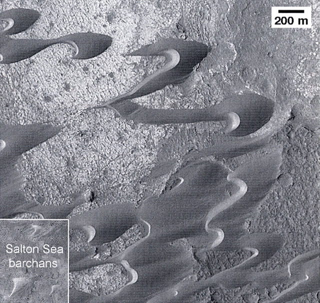
Wind is the current dominant erosive and degrading process on Mars, consequently studying terrestrial wind environments is very important for expanding our understanding of this process on Mars, as well as how and why it differs from Earth. Chapter 9, titled, "Eolian dunes and deposits in the western United States as analogs to wind-related features on Mars," identifies a suite of wind-formed features, such as sand dunes, in the western US that can be compared to similar features on Mars. Image of large barchans and barchanoid ridges on the floor of Nil Patera on Mars. -http://www.nasm.si.edu/research/ceps/research/mars/terrestrial_analogues.cfm |
Close-up view of ''hill'' feature in Tithonium Chasma. In the eastern part of the Tithonium Chasma trough, an interesting hill exhibits linear features. These structures could have been caused by fluvial or aeolian erosion.http://www.esa.int/esa-mmg/mmg.pl?b=b&type=I&mission=Mars%20Express&single=y&start=506&size=b |
Close-up view of ''hill'' feature in Tithonium Chasma |
These images of æyardangsÆ, features sculpted by wind-blown sand seen here near Olympus Mons on Mars, were obtained by the High Resolution Stereo Camera (HRSC) on board the ESA Mars Express spacecraft. This image was taken during orbit 143 with a resolution of 20 metres per pixel. The scene show a structure south of Olympus Mons at 6░ N latitude and 220░ E longitude, which was probably formed by the action of the wind.http://www.esa.int/esa-mmg/mmg.pl?b=b&type=I&mission=Mars%20Express&single=y&start=592&size=b |
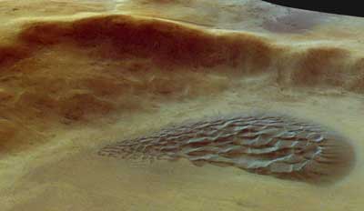
Close-up of the dune field This image was taken during orbit 427 on 27 May 2004, and shows the crater with a dune field located in the north-western part of the Argyre Planitia crater basin http://www.esa.int/esa-mmg/mmg.pl?b=b&type=I&mission=Mars%20Express&single=y&start=588&size=b |
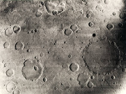
This is one of the first photographs of Mars taken by the Mariner 6 spacecraft in 1969. At the time scientists were both surprised and disappointed that, like the moon, the surface of Mars was scarred by impact craters |
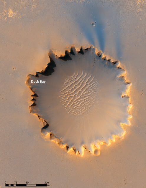
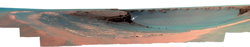
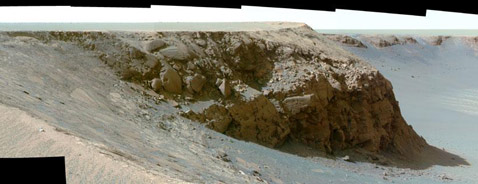
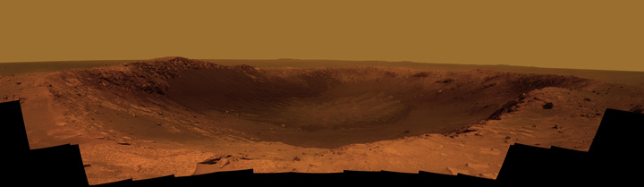
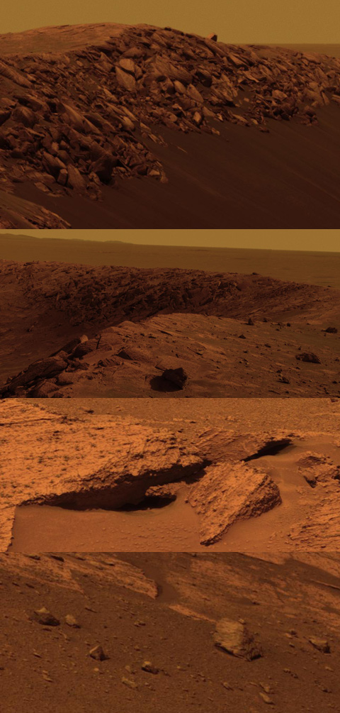
Victoria crater, located in Meridiani Planum, is ~750 m in diameter and ~ 75 m deep. This impact structure retains a ~5 m raised rim consisting of 1-2 m of uplifted rocks overlain by ~ 3 m ejecta at the rim crest . Color HiRiSE image (TRA_00873_1780) of Victoria Crater in Meridiani Planum, Mars, showing the degraded, scalloped rim and sand dunes in the crater interior. See Figure 2 for the Opportunity roverÆs view of Duck Bay-http://www.nasm.si.edu/research/ceps/research/mars/victoria_crater.cfm |
False color mosaic taken by Opportunity rover''s panoramic camera looking east into Victoria crater from Duck Bay (see Figure 1 for context). Base of Cape Verde (white arrow) appears notches at the base and are fairly free of flanking talus. Note the smooth expression of the exposed, fractured bedrock on the floor of Duck Bay and ramps of darker basaltic sand on the lower surfaces of this and other bays |
Crater victoria (NASA/JPL-Caltech/Cornell) |
Schiaparelli is a large impact basin about 460 km across, located in the eastern Terra Meridiani region of the planetÆs equator. The image shows just a small part of the basinÆs northwestern rim cutting diagonally across the image (top left¢bottom right) and a smaller 42-km-diameter crater embedded in its rim. The image is centred on the equator of Mars, at a longitude of about 14░E. The image was taken on 15 July 2010 -http://www.esa.int/esa-mmg/mmg.pl?b=b&type=I&mission=Mars%20Express&single=y&start=89&size=b |
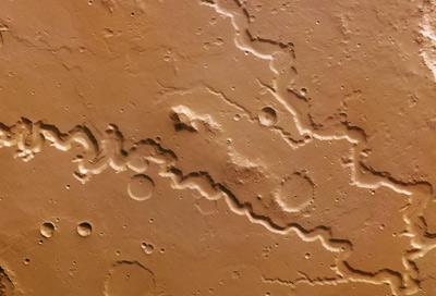
This image of Hephaestus Fossae was obtained by ESAÆs Mars Express orbiter on 28 December 2007. The region is dotted with craters and channel systems and lies at about 21░N and 126░E on the Red Planet. Named after the Greek god of fire, Hephaestus Fossae extends for more than 600 km on the western flank of Elysium Mons in the Utopia Planitia region. The scale is in metres - http://www.esa.int/esa-mmg/mmg.pl?b=b&type=I&mission=Mars%20Express&single=y&start=146&size=b. |
The surface of Hephaestus Fossae is mostly smooth, and is covered by several small impact craters measuring 800 to 2800 m in diameter. Smaller craters are scattered across the entire region. A larger impact crater measuring 20 km in diameter is a prominent feature. Covering an area of approximately 150 sq km, this crater could harbour cities such as Bonn or Kiel. In contrast to the smaller craters, it shows a blanket of ejecta with flow forms surrounding the rim. The large craters were formed when loose, soft material was ejected due to impact, and the smaller ones formed due to secondary impacts, when consolidated material was ejected in a ballistic path and impacted the original crater at varying distances. Most martian water exists in the form of subsurface ice. The presence of a blanket of ejecta and outflow channels around the crater suggest that the primary impact may have penetrated the surface enough to melt a buried frozen water reservoir- http://www.esa.int/esa-mmg/mmg.pl?b=b&type=I&mission=Mars%20Express&start=12. |
Crommelin Crater on Mars, an area where Light Toned Deposits, or LTD, are known to be present. An analysis of data and images from Mars Express suggests that several LTD, some of the least understood structures on Mars, were formed when large amounts of groundwater burst on to the surface. Scientists propose that groundwater had a greater role in shaping the martian surface than previously believed, and may have sheltered primitive life forms as the planet started drying up- http://www.esa.int/esa-mmg/mmg.pl?b=b&type=I&mission=Mars%20Express&single=y&start=169&size=b |
The HRSC onboard the ESA spacecraft Mars Express obtained images focusing on a depression that displays a crater at the end of the long, winding valley, Mamers Valles. The data was obtained on 5 August 2006 with a ground resolution of approximately 14 m/per pixel. The image is centred at approximately 39░ north and 17░ east on the planet. The ortho-image was rectified using elevation data derived from an High-Resolution Stereo Camera (HRSC) -derived high-resolution Digital Terrain Model (DTM) so that distortions introduced during imaging are corrected. Such an image can be used to derive maps. Elevation data from the DTM has been colour-coded and overlain on the ortho-image so that elevation data and the image itself are displayed in a single scene. The scale is in metres. http://www.esa.int/esa-mmg/mmg.pl?b=b&type=I&mission=Mars%20Express&start=21 |
Mamers Valles perspective view |
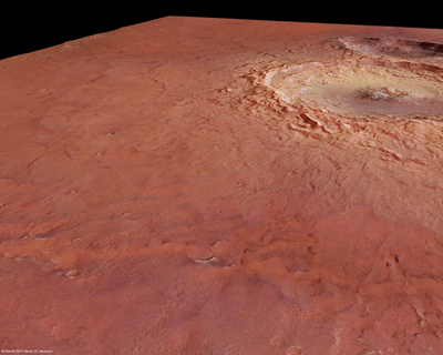
The above image shows the striking Maunder crater lying at approximately 50░ South and 2░ East, in the Noachis Terra region on Mars. The High Resolution Stereo Camera (HRSC) on ESAÆs Mars Express orbiter took pictures of the Noachis Terra region during orbits 2412 and 2467 on 29 November and 14 December 2005 respectively, with a ground resolution of approximately 15 metres per pixel. The sun illuminates the scene from the north-east (top left in the image). Maunder crater, named after the british astronomer Edward W. Maunder, is located halfway between Argyre Planitia and Hellas Planitia on the southern highlands of Mars. With a diameter of 90 kilometres and a depth of barely 900 metres, the crater is not one of the largest impact craters on Mars at present, but it used to be much deeper. It has since been filled partially with large amounts of material. http://www.esa.int/esa-mmg/mmg.pl?b=b&type=I&mission=Mars%20Express&start=25 |
The above image shows the striking Maunder crater located in the region of Noachis Terra on Mars. The crater lies at 50░ South and 2░ East. The High Resolution Stereo Camera (HRSC) on ESAÆs Mars Express orbiter took pictures of the Noachis Terra region during orbits 2412 and 2467 on 29 November and 14 December 2005, respectively, with a ground resolution of approximately 15 metres per pixel.Named after the british astronomer Edward W. Maunder, the crater located halfway between Argyre Planitia and Hellas Planitia on the southern Highlands of Mars |
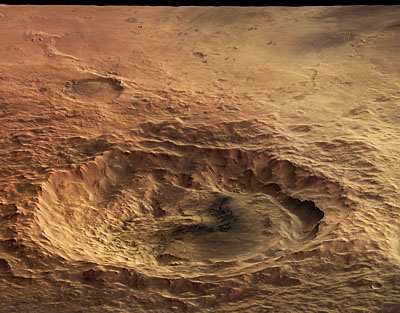
Tyrrhena Terra perspective view. The western part of the scene is dominated by a 35 kilometre-wide and approximately 1000 metre-deep impact crater with an extremely cliffy and chiseled edge. Another, 18 kilometre-long and approximately 750 metre-deep impact crater, in all likelihood a ædouble impact craterÆ, is located south of the large crater. These ædouble impact cratersÆ develop when two objects, part of a binary, hit the surface almost simultaneously. http://www.esa.int/esa-mmg/mmg.pl?b=b&type=I&mission=Mars%20Express&start=26 |
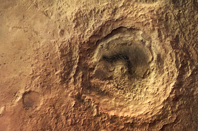
Close-up perspective view of ''butterfly'' crater The HRSC on board ESA''s Mars Express spacecraft obtained this perspective view on 5 May 2004 during orbit 368 with a ground resolution of approximately 16.7 metres per pixel. The scene shows the region of Hesperia Planum, at approximately 35.3░ South and 118.7░ East, looking north. A large elliptical impact crater is visible, measuring approximately 24.4 km long, 11.2 km wide and reaching a maximum depth of approximately 650 metres below the surrounding plains. http://www.esa.int/esa-mmg/mmg.pl?b=b&type=I&mission=Mars%20Express&start=37 |
Santa Maria(NASA/JPL-Caltech/Cornell/ASU), 2011. |
Santa Maria.(NASA/JPL-Caltech/Cornell/ASU). |
Eos Chasma ( ESA) - meteorite ALH 84001 came from here- http://www.membrana.ru/particle/9142 |

Martian surface morphology records a complex, changeable geologic history that suggests the planet may have been more hospitable to life during its early history. While the present atmosphere is predominantly CO2 and only about 1% of the density of Earth''s atmosphere, some evidence suggests it was denser and warmer in the past. For example, most of the valleys and channels cutting the surface are thought to have been created by flowing water, something that is nearly impossible to sustain under present cold conditions (the average temperature is -23░C). Possible relationships between the atmosphere, the planet''s water cycle, and any possible biotic activity on the planet remain the focus of much research.
Martian Geology
Modern Martian Surface
Warm-Season Flows on Slope in Newton Crater
Martian Life
Links