 | Марс |
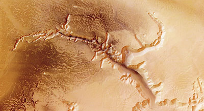
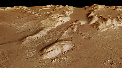
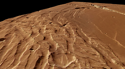
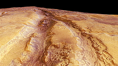
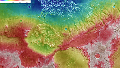
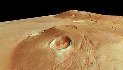
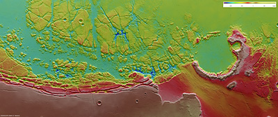
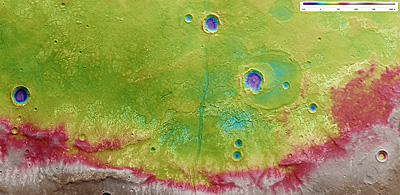
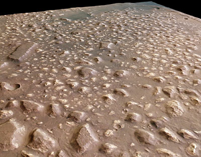
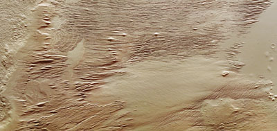
Долины Маринер. Большинство исследователей полагают, что долины Маринер образовались на ранних этапах формирования Марса в результате остывания планеты. Ширина каньонов со временем увеличилась в результате эрозии. Возможно долины Маринер сформировались в результате процесса, схожего с появлением рифтового разлома в Восточной Африке. http://ru.wikipedia.org/wiki/%D0%94%D0%BE%D0%BB%D0%B8%D0%BD%D0%B0_%D0%9C%D0%B0%D1%80%D0%B8%D0%BD%D0%B5%D1%80%D0%B0 |
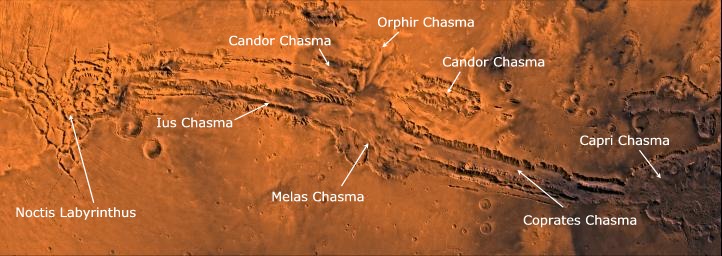
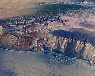
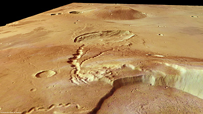
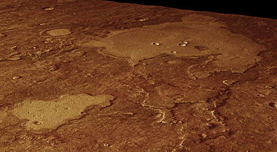
Долина Маринера – самая величественная и известная деталь рельефа планеты. Этот каньон вытянулся на четверть окружности Марса (фото NASA/JPL/Arizona State University)-http://www.nasa.gov/mission_pages/odyssey/odyssey20100723.html. |
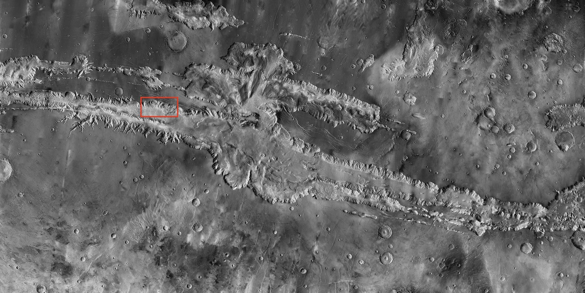
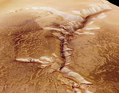
Valles Marineris, the "Grand Canyon of Mars," sprawls wide enough to reach from Los Angeles nearly to New York City, if it were located on Earth. The red outline box shows the location of the second, full-resolution image. Credit: NASA/JPL/Arizona State University - http://asunews.asu.edu/20100723_marsmap |
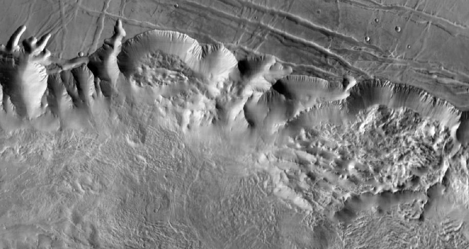
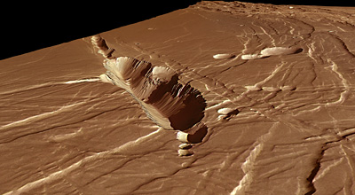
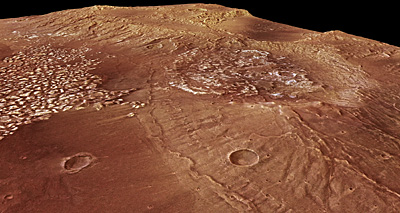
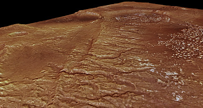
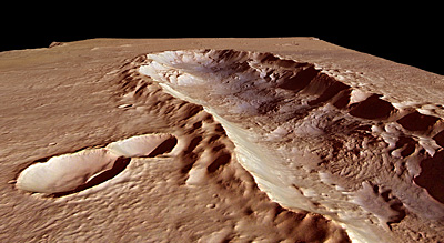
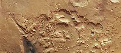
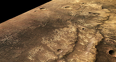
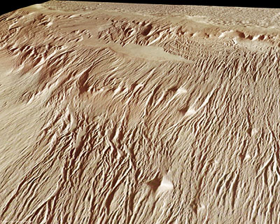
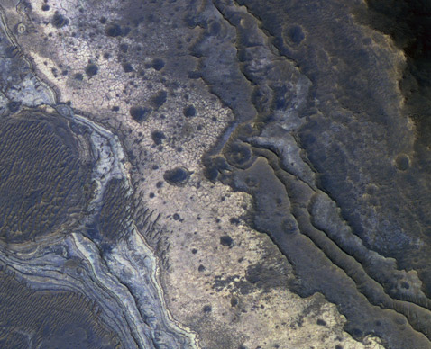
Лабиринт Ночи находится с западного края долин Маринер, к северу от плато Сирия, к востоку от вулкана горы Павлина. Лабиринт Ночи, возможно, сформировался под воздействием воды или углекислоты, которая могла бурно извергаться на поверхность с переходом в жидкое и газообразное состояние.Это сильно изрезанная местность с каньонами, идущими в разных направлениях.Долины и каньоны проходят между массивными блоками, состоящими в своей основе из древних материалов. Однако верхний трещиноватый слой большинства блоков имеет, вероятно, более позднее вулканическое происхождение (ассоциируемое с вулканами в провинции Фарсида). Стенки блоков состоят из сплошного, однородного материала. Поверхность между блоками местами гладкая, местами неровная. Неровная поверхность в большей степени характерна для восточной части Лабиринта. Возможно неровности связаны с ветровыми наносами поверх неоднородного ландшафта и эрозией, возможно это обломки стенок. Гладкие участки могли образоваться подобно речным наносам (при течении жидкости) либо в результате ветряных наносов |
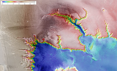
The High-Resolution Stereo Camera (HRSC) on board ESA’s Mars Express has returned images of Echus Chasma, one of the largest water source regions on the Red Planet. Echus Chasma is the source region of Kasei Valles which extends 3000 km to the north. The data was acquired on 25 September 2005. The pictures are centred at about 1° north and 278° east and have a ground resolution of approximately 17 m/pixel.http://www.esa.int/esa-mmg/mmg.pl?b=b&type=I&mission=Mars%20Express&single=y&start=227&size=b |
The High-Resolution Stereo Camera (HRSC) on board ESA’s Mars Express has returned images of Echus Chasma, one of the largest water source regions on the Red Planet. Echus Chasma is the source region of Kasei Valles which extends 3000 km to the north. The data was acquired on 25 September 2005. The pictures are centred at about 1° north and 278° east and have a ground resolution of approximately 17 m/pixel. The ortho-image was rectified using elevation data derived from a high-resolution Digital Terrain Model, or DTM (obtained from HRSC data), such that distortions introduced during imaging are corrected. Such an image can be used to derive maps. Elevation data from the DTM has been colour-coded and overlain on the ortho-image so that elevation data and the image itself are displayed in a single scene- http://www.esa.int/esa-mmg/mmg.pl?b=b&type=I&mission=Mars%20Express&single=y&start=229&size=b. |
The High-Resolution Stereo Camera (HRSC) on board ESA’s Mars Express has returned images of Echus Chasma, one of the largest water source regions on the Red Planet. Echus Chasma is the source region of Kasei Valles which extends 3000 km to the north. The data was acquired on 25 September 2005. The pictures are centred at about 1° north and 278° east and have a ground resolution of approximately 17 m/pixel. An impressive cliff, up to 4000 m high, is located in the eastern part of Echus Chasma. Gigantic water falls may once have plunged over these cliffs on to the valley floor. The remarkably smooth valley floor was later flooded by basaltic lava.http://www.esa.int/esa-mmg/mmg.pl?b=b&type=I&mission=Mars%20Express&start=20 |
The High-Resolution Stereo Camera (HRSC) on board ESA’s Mars Express has returned images of Echus Chasma, one of the largest water source regions on the Red Planet. Echus Chasma is the source region of Kasei Valles which extends 3000 km to the north. The data was acquired on 25 September 2005. The pictures are centred at about 1° north and 278° east and have a ground resolution of approximately 17 m/pixel. The dark material shows a network of light-coloured, incised valleys that look similar to drainage networks known on Earth. It is still debated whether the valleys originate from precipitation, groundwater springs or liquid or magma flows on the surface.http://www.esa.int/esa-mmg/mmg.pl?b=b&type=I&mission=Mars%20Express&start=20 |
The High-Resolution Stereo Camera (HRSC) on board ESA’s Mars Express has returned images of Echus Chasma, one of the largest water source regions on the Red Planet. Echus Chasma is the source region of Kasei Valles which extends 3000 km to the north. The data was acquired on 25 September 2005. The pictures are centred at about 1° north and 278° east and have a ground resolution of approximately 17 m/pixel. |
The High-Resolution Stereo Camera (HRSC) on board ESA’s Mars Express has returned images of Echus Chasma, one of the largest water source regions on the Red Planet. Echus Chasma is the source region of Kasei Valles which extends 3000 km to the north. |
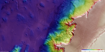
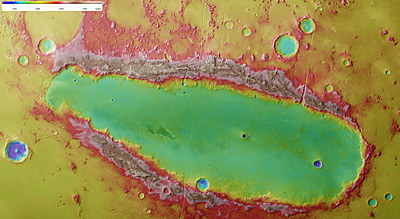
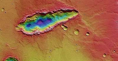
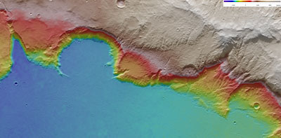
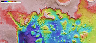
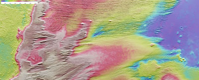
Melas Chasma is part of the huge Valles Marineris rift valley, which stretches for more than 4000 km across the face of Mars. Melas Chasma itself sinks 9 km below the surrounding surface, making it one of the lowest depressions on Mars. This image was created using a Digital Terrain Model (DTM) obtained from the High Resolution Stereo Camera on ESA’s Mars Express spacecraft. Elevation data from the DTM are colour-coded: purple indicates the lowest-lying regions, and beige the highest elevations. The scale is in metres- http://www.esa.int/esa-mmg/mmg.pl?b=b&type=I&mission=Mars%20Express&start=9 |
Melas Chasma is part of the huge Valles Marineris rift valley on Mars. Melas Chasma itself sinks 9 km below the surrounding surface, making it one of the lowest depressions on the planet. The flow patterns in the canyon floor show that it must once have been covered by liquid water or water ice-http://www.esa.int/esa-mmg/mmg.pl?b=b&type=I&mission=Mars%20Express&start=8 |
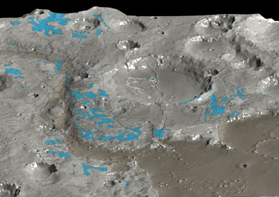
2 December 2011 - the Phlegra Montes mountain range is a region where radar probing indicates large volumes of water ice are hiding below. Phlegra Montes in perspective. http://www.esa.int/export/SPECIALS/Mars_Express/SEMUGI2XFVG_0.html - Mountains and buried ice on Mars |
Phlegra Montes in perspective. A wider contextual image of the region surrounding Phlegra Montes. The smaller rectangle shows the region covered in this Mars Express HRSC image release- http://www.esa.int/export/SPECIALS/Mars_Express/SEMUGI2XFVG_0.html. |
Phlegra Montes is a range of gently curving mountains and ridges on Mars. They extend from the northeastern portion of the Elysium volcanic province to the northern lowlands. This image is centred at 33°N/162°E. - http://www.esa.int/export/SPECIALS/Mars_Express/SEMUGI2XFVG_1.html |
The image was created using a Digital Terrain Model (DTM) obtained from the High-Resolution Stereo Camera on ESA’s Mars Express spacecraft. Elevation data from the DTM is colour coded: purple indicates the lowest lying regions and grey the highest. The scale is in metres. The High-Resolution Stereo Camera (HRSC) on ESA’s Mars Express collected the data for these images on 1 June 2011 during orbit 9465-http://www.esa.int/export/SPECIALS/Mars_Express/SEMUGI2XFVG_0.html. |
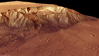
Phoenicis Lacus was formed by the uplift of the Tharsis volcanic plateau. The continual episodes of strong volcanic activity in Tharsis not only lifted the plateau, but also deformed Phoenicis Lacus, creating blocks and multiple fault lines at different orientations. Extension has taken place here, resulting in this characteristic horst-and-graben (cliffs and valleys) landscape |
This prominent collapse feature in Phoenicis Lacus sinks to a depth of about 3 km below the surrounding terrain. Its walls give a glimpse of the likely extensive basalt layers in the canyon. A small field of sand dunes covers its floor. |
Phoenicis Lacus was formed by the uplift of the Tharsis volcanic plateau. The continual episodes of strong volcanic activity in Tharsis not only lifted the plateau, but also deformed Phoenicis Lacus, creating uplifted blocks and multiple fault lines at different orientations. A prominent collapse feature in Phoenicis Lacus sinks to a depth of about 3 km below the surrounding terrain. This image was created using a Digital Terrain Model (DTM)- http://www.esa.int/esa-mmg/mmg.pl?b=b&type=I&mission=Mars%20Express&start=8 |
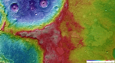
Nili Fossae is a graben system on Mars. It is found at 22°N / 77°E, northeast of the Syrtis Major volcanic province, on the northwestern edge of the giant Isidis impact basin. This image shows an area covering approximately 10 300 sq km. It was taken during orbit 5270, on 8 February 2008- http://www.esa.int/esa-mmg/mmg.pl?b=b&type=I&mission=Mars%20Express&start=5 |
Nili Fossae is a graben system on Mars, northeast of the Syrtis Major volcanic, on the northwestern edge of the giant Isidis impact basin. Some of these incisions into the martian crust are up to 500 m deep and probably formed at the same time as the basin- http://www.esa.int/esa-mmg/mmg.pl?b=b&type=I&mission=Mars%20Express&start=4 |
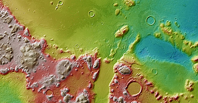
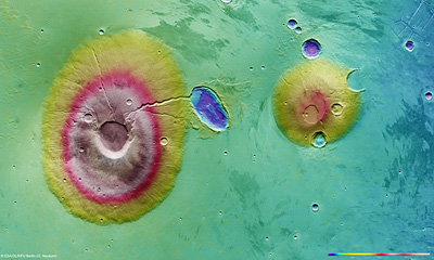
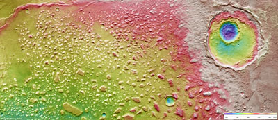
Orcus Patera is an enigmatic elliptical depression located between the volcanoes of Elysium Mons and Olympus Mons. This well-defined depression extends approximately 380 km by 140 km in a NNE–SSW direction. It has a rim that rises up to 1800 m above the surrounding plains, while the floor of the depression lies 400–600 m below the surroundings. This image was created using a Digital Terrain Model (DTM) obtained from the High Resolution Stereo Camera on ESA’s Mars Express spacecraft. Elevation data from the DTM are colour-coded: purple indicates the lowest-lying regions, and beige the higher elevations. The scale is in metres-http://www.esa.int/esa-mmg/mmg.pl?b=b&type=I&mission=Mars%20Express&start=9 |
Orcus Patera is an enigmatic elliptical depression located between the volcanoes of Elysium Mons and Olympus Mons. This well-defined depression extends approximately 380 km by 140 km in a NNE–SSW direction. It has a rim that rises up to 1800 m above the surrounding plains, while the floor of the depression lies 400–600 m below the surroundings. The straight graben that cut across its rim are clearly seen in this image. |
Orcus Patera is an enigmatic elliptical depression located between the volcanoes of Elysium Mons and Olympus Mons. This well-defined depression extends approximately 380 km by 140 km in a NNE–SSW direction. It has a rim that rises up to 1800 m above the surrounding plains, while the floor of the depression lies 400–600 m below the surroundings. |
This image of Magellan Crater stretches across 190 x 112 km, and covers an area of about 21 280 sq km, which is roughly the size of Slovenia. It is to the southwest of the volcanic region Tharsis on the southern highlands of Mars. This image was created using a Digital Terrain Model (DTM) obtained from the High Resolution Stereo Camera on ESA’s Mars Express spacecraft. Elevation data from the DTM is colour-coded: blue indicates the lowest-lying regions, and beige the higher elevations. The scale is in metres-http://www.esa.int/esa-mmg/mmg.pl?b=b&type=I&mission=Mars%20Express&start=10 |
Looking towards Magellan Crater across the smooth plateau and the rock mounds of the region |
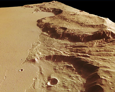
Deep valleys dominate this section of the Magellan Crater on Mars. They may have been created by the enormous stresses places on the planet’s crust by the upsurge of the Tharsis region-http://www.esa.int/esa-mmg/mmg.pl?b=b&type=I&mission=Mars%20Express&single=y&start=112&size=b |
Ceraunius Tholus and Uranius Tholus are two volcanoes in the Tharsis region of Mars. Ceraunius Tholus is 130 km across and rises 5.5 km above its surroundings. Its neighbour, Uranius Tholus is a smaller volcano, with a base diameter of 62 km and a height of 4.5 km. The image was created using a Digital Terrain Model (DTM) -http://www.esa.int/esa-mmg/mmg.pl?b=b&type=I&mission=Mars%20Express&start=5 |
Ceraunius Tholus and Uranius Tholus are two volcanoes in the Tharsis region of Mars. Ceraunius Tholus is 130 km across and rises 5.5 km above its surroundings. Its neighbour, Uranius Tholus is a smaller volcano, with a base diameter of 62 km and a height of 4.5 km. |
Ceraunius Tholus and Uranius Tholus are two volcanoes in the Tharsis region of Mars. Ceraunius Tholus is 130 km across and rises 5.5 km above its surroundings. Its neighbour, Uranius Tholus is a smaller volcano, with a base diameter of 62 km and a height of 4.5 km. The High Resolution Stereo Camera on ESA’s Mars Express took this image. The perspective view has been calculated from the digital terrain model derived from the stereo channels-http://www.esa.int/esa-mmg/mmg.pl?b=b&type=I&mission=Mars%20Express&single=y&start=57&size=b |
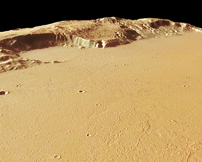
This unnamed elongated depression is located just to the south of the much larger Huygens crater. It is about 78 km in length, opens from just under 10 km wide at one end to 25 km wide at the other, and reaches a depth of 2 km. The image was created using a Digital Terrain Model (DTM) |
This unnamed elongated depression is located just to the south of the much larger Huygens crater. It is about 78 km in length, opens from just under 10 km wide at one end to 25 km wide at the other, and reaches a depth of 2 km. A blanket of material that looks as if it was ejected from an impact surrounds it. The data were acquired during orbit 8433 on 4 August 2010 using the High Resolution Stereo Camera on Mars Express. |
The Mangala Fossae trough, a system of outflow channels on Mars that bears evidence of lava deposition and catastrophic floods. The HRSC on board Mars Express obtained images of this region centred at 17° south and 213° east on 21 March 2007. Mangala Fossae is approximately 1000 km long, located south-west of the volcanic region Tharsis, where the highest known volcano in the Solar System, Olympus Mons, is located. The ortho-image was rectified using elevation data derived from a high-resolution Digital Terrain Model, or DTM (obtained from HRSC data), such that distortions introduced during imaging are corrected. Such an image can be used to derive maps. Elevation data from the DTM has been colour-coded and overlain on the ortho-image so that elevation data and the image itself are displayed in a single scene. The scale is in metres- http://www.esa.int/esa-mmg/mmg.pl?b=b&type=I&mission=Mars%20Express&single=y&start=197&size=b. |
The Mangala Fossae trough is a system of outflow channels on Mars that bears evidence of lava deposition and catastrophic floods.The HRSC on board Mars Express obtained images of this region centred at 17° south and 213° east on 21 March 2007. Mangala Fossae is approximately 1000 km long, located south-west of the volcanic region Tharsis, where the highest known volcano in the Solar System, Olympus Mons, is located. The western part of the region is remarkably smooth and exhibits just a few small impact craters, larger craters being absent. Since the crater count relates directly to the age of the region (the more the number of craters, the older the uppermost layer of material), and only few small craters are seen in the area, this indicates that the uppermost surface layer is young and that the basaltic lava was put in place relatively recently. This perspective view has been calculated from the digital terrain model derived from the stereo channels http://www.esa.int/esa-mmg/mmg.pl?b=b&type=I&mission=Mars%20Express&single=y&start=206&size=b-. |
The Mangala Fossae trough is a system of outflow channels on Mars that bears evidence of lava deposition and catastrophic floods. |
This image stretches 159 km by 87 km and shows a region about a third the size of Denmark. It is the eastern part of Arabia Terra, about 300 km NW of Antoniadi Crater. The image was created using a Digital Terrain Model (DTM) obtained from the High Resolution Stereo Camera on ESA’s Mars Express spacecraft. Elevation data from the DTM is colour coded: purple indicates the lowest lying regions and beige the highest; the scale is in metres-http://www.esa.int/esa-mmg/mmg.pl?b=b&type=I&mission=Mars%20Express&start=7 |
This is the eastern part of Arabia Terra, part of the highlands of Mars. Large, irregular deposits have proved more resistant to erosion than their surroundings. |
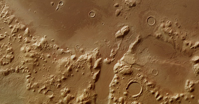
Mars Express flew over the boundary between Kasei Valles and Sacra Fossae and imaged the region, acquiring spectacular views of the chaotic terrain in the area. The images are centred at 12°N / 285°E and have a ground resolution of about 21 m/pixel. They cover 225 x 95 km or 21.375 sq km, an area roughly half the size of the Netherlands. The scale is in metres-http://www.esa.int/esa-mmg/mmg.pl?b=b&type=I&mission=Mars%20Express&single=y&start=124&size=b. |
Mars Express flew over the boundary between Kasei Valles and Sacra Fossae and imaged the region, acquiring spectacular views of the chaotic terrain in the area. The images are centred at 12°N / 285°E and have a ground resolution of about 21 m/pixel. They cover 225 x 95 km or 21.375 sq km, an area roughly half the size of the Netherlands. The image shows an old 35 km-diameter impact crater in the north. The crater’s southwestern rim is eroded strongly, mostly by flowing water. The source of the water was located in Echus Chasma, which lies about 850 km to the southwest. The crater floor and the northwestern part are remarkably flat, formed by sediments and basaltic lava flows from the Tharsis volcanic region. The lower part of the image clearly shows the boundary between the smooth, lightly cratered plain, and the area with numerous fracture zones. Most of the fractures along the boundary are parallel to the edge of the Lunae Planum. Several fracture zones are also visible in the western part. Up to 10 km-sized areas that experienced ‘subsidence’ (gradual compaction and sinking due to the weight of the layers) are still intact- http://www.esa.int/esa-mmg/mmg.pl?b=b&type=I&mission=Mars%20Express&single=y&start=127&size=b. |
Mars Express flew over the boundary between Kasei Valles and Sacra Fossae and imaged the region, acquiring spectacular views of the chaotic terrain in the area. The images are centred at 12°N / 285°E and have a ground resolution of about 21 m/pixel. They cover 225 x 95 km or 21.375 sq km, an area roughly half the size of the Netherlands. The image shows an old 35 km-diameter impact crater in the north. The crater’s southwestern rim is eroded strongly, mostly by flowing water. The source of the water was located in Echus Chasma, which lies about 850 km to the southwest. The crater floor and the northwestern part are remarkably flat, formed by sediments and basaltic lava flows from the Tharsis volcanic region.The lower part of the image clearly shows the boundary between the smooth, lightly cratered plain, and the area with numerous fracture zones. Most of the fractures along the boundary are parallel to the edge of the Lunae Planum- http://www.esa.int/esa-mmg/mmg.pl?b=b&type=I&mission=Mars%20Express&single=y&start=126&size=b |
This is an ortho-image of Nepenthes Mensae. The image is overlaid with elevation data from an HRSC-derived high-resolution digital terrain model (DTM). In an ortho-image, the projecting rays are perpendicular to the plane of projection. This corrects any deformations introduced by an imaging camera. Such an image can be fitted directly on to a map- http://www.esa.int/esa-mmg/mmg.pl?b=b&type=I&mission=Mars%20Express&single=y&start=252&size=b. |
The High Resolution Stereo Camera on board ESA’s Mars Express orbiter imaged Nepenthes Mensae, a river delta on Mars, on 22 January 2008. |
The High Resolution Stereo Camera on board ESA’s Mars Express orbiter imaged Nepenthes Mensae, a river delta on Mars, on 22 January 2008.The data was acquired in the region lying at approximately 3° north and 121° east with a ground resolution of 15 m/pixel - http://www.esa.int/esa-mmg/mmg.pl?b=b&type=I&mission=Mars%20Express&single=y&start=251&size=b. |
The High Resolution Stereo Camera on board ESA’s Mars Express orbiter imaged Nepenthes Mensae, a river delta on Mars, on 22 January 2008. The data was acquired in the region lying at approximately 3° north and 121° east with a ground resolution of 15 m/pixel |
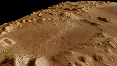
Mars Express image of a region close to Ma’adim Vallis, one of the largest canyons on Mars. After Valles Marineris, Ma’adim Vallis is one of the largest canyons on Mars. The imaged region lies south-east of Ma’adim Vallis; the pictures are centred at about 29°S and 182°E and have a ground resolution of 15 m/pixel. Ma’adim Vallis is located between the volcanic region of Tharsis, which harbours four volcanoes, including the largest in the Solar System, and the Hellas Planitia impact basin. The canyon, 20 km wide and 2 km deep, originates in the southern highlands close to the ‘dichotomy boundary’ and ends in Gusev crater. The dichotomy boundary is a narrow region separating the cratered highlands, located mostly in the southern hemisphere of Mars, from the northern hemisphere''s lowland plains. This ortho-image was rectified using elevation data derived from a high-resolution Digital Terrain Model, or DTM (obtained from HRSC data), such that distortions introduced during imaging are corrected. Such an image can be used to derive maps. Elevation data from the DTM has been colour-coded and overlain on the ortho-image so that elevation data and the image itself are displayed in a single scene. |
Mars Express image of a region close to Ma’adim Vallis, one of the largest canyons on Mars. After Valles Marineris, Ma’adim Vallis is one of the largest canyons on Mars. The imaged region lies south-east of Ma’adim Vallis; the pictures are centred at about 29°S and 182°E and have a ground resolution of 15 m/pixel. Ma’adim Vallis is located between the volcanic region of Tharsis, which harbours four volcanoes, including the largest in the Solar System, and the Hellas Planitia impact basin. The canyon, 20 km wide and 2 km deep, originates in the southern highlands close to the ‘dichotomy boundary’ and ends in Gusev crater. The dichotomy boundary is a narrow region separating the cratered highlands, located mostly in the southern hemisphere of Mars, from the northern hemisphere''s lowland plains.The images cover 138 x 70 km, roughly the size of Cyprus. A sharp boundary is visible in the centre, dividing dark material to the west and light material to the east. Scientists suspect that this feature is most likely the edge of a basaltic lava flow http://www.esa.int/esa-mmg/mmg.pl?b=b&type=I&mission=Mars%20Express&single=y&start=134&size=b-. |
The images cover 138 x 70 km, roughly the size of Cyprus. A sharp boundary is visible in the centre, dividing dark material to the west and light material to the east. Scientists suspect that this feature is most likely the edge of a basaltic lava flow. Wrinkle ridges are clearly visible on the surface of the lava flow. They were most likely formed by compressive forces. To the north is a crater, almost 20 km in size. It is partially filled with lava, which shows that it must have formed before the lava set in. The smaller, 7 km crater at the southern edge of the larger crater must have formed later because it has an ejecta blanket that may have formed from material rich in water-ice ejected during impact http://www.esa.int/esa-mmg/mmg.pl?b=b&type=I&mission=Mars%20Express&single=y&start=135&size=b-. |
16 April 2007 in the region of Ariadnes Colles that lies at about 34° south and 172° east. The ground resolution is about 13 m/pixel. This ortho-image was rectified using elevation data derived from a high-resolution Digital Terrain Model, or DTM (obtained from HRSC data), such that distortions introduced during imaging are corrected. Such an image can be used to derive maps. Elevation data from the DTM has been colour-coded and overlain on the ortho-image so that elevation data and the image itself are displayed in a single scene. The scale is in metres- http://www.esa.int/esa-mmg/mmg.pl?b=b&type=I&mission=Mars%20Express&start=13. |
Ariadnes Colles, perspective view |
ESA’s Mars Express orbiter imaged the snow-laden region of Rupes Tenuis on the martian north pole on 29 July 2008. Rupes Tenuis is located at the southern edge of the martian north polar cap, approximately 5500 km northeast of the Tharsis volcanic region. The images are at about 81° north and 297° east and have a ground resolution of approximately 41 m/pixel. They cover an area of about 44 000 km2, almost as large as the Netherlands-http://www.esa.int/esa-mmg/mmg.pl?b=b&type=I&mission=Mars%20Express&start=13. |
Rupes Tenuis (this is perspective view) is located at the southern edge of the martian north polar cap, approximately 5500 km northeast of the Tharsis volcanic region. The images are at about 81° north and 297° east and have a ground resolution of approximately 41 m/pixel. They cover an area of about 44 000 km2, almost as large as the Netherlands |
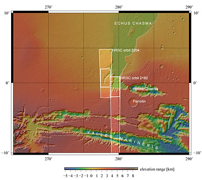
Perspective view of Hebes Chasma that is located at approximately 1° south and 282° east. The HRSC obtained image data on 16 September 2005 with a ground resolution of approximately 15 m/pixel. |
Eumenides Dorsum is located in to the west of the Tharsis Region, and forms part of the Medusae-Fossae Region, at approximately 2° south and 206° east. The images, taken on 26 December 2007, have a ground resolution of about 13 m/pixel and cover an area of about 12 000 square km-http://www.esa.int/esa-mmg/mmg.pl?b=b&type=I&mission=Mars%20Express&single=y&start=178&size=b. |
Eumenides Dorsum is located in to the west of the Tharsis Region, and forms part of the Medusae-Fossae Region, at approximately 2° south and 206° east. The images, taken on 26 December 2007, have a ground resolution of about 13 m/pixel and cover an area of about 12 000 square km. |
Eumenides Dorsum. The region exhibits several kilometre-long linear structures interspersed with channels. The entire area bears evidence of the erosional force of wind, and possibly water, on Mars. Although the martian atmosphere is rather thin compared to the Earth’s atmosphere – just 0.75% of mean surface pressure on Earth, corresponding to an altitude of about 35 km above Earth’s surface – it can be very dynamic and plays a major role in shaping the Red Planet’s landscape over a long period of time. The region is dominated by features carved in sedimentary rocks created by the erosional action of the wind. The wind transports loose material, such as sand, and erodes the soft sedimentary rocks along existing structures like gaps, fault lines or incisions, removing the material. Smaller mounds in the image centre have been eroded and look pyramid-shaped. In the imaged area, most of these features are oriented from north to south. Such preferential orientation develops in areas where the wind direction remains the same -http://www.esa.int/esa-mmg/mmg.pl?b=b&type=I&mission=Mars%20Express&start=16 |
The region exhibits several kilometre-long linear structures interspersed with channels. The entire area bears evidence of the erosional force of wind, and possibly water, on Mars. |
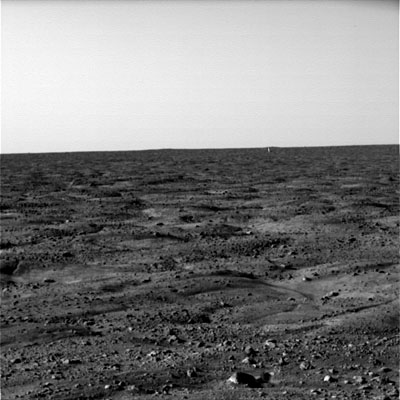
The martian surface, seen by Phoenix |
The martian surface, seen by Phoenix |
Iani Chaos on Mars, an area where Light Toned Deposits, or LTD, are known to be present. |
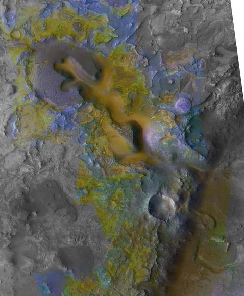
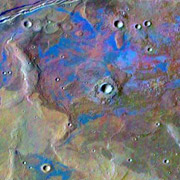
Американский спутник Mars Reconnaissance Orbiter обнаружил на Марсе карбонатные минералы. А это значит, что подкислённая вода доминировала не на всей поверхности Марса, как думали ранее, хватало воды c нейтральной pH. Карбонаты были найдены в регионе Nili Fossae. Композитное изображение участка местности с поперечником около 20 км. Различными цветами показаны разные минералы, выявленные спектрометром. Карбонаты отражены зелёным (фото NASA/JPL/JHUAPL/MSSS/Brown University) - http://mars.jpl.nasa.gov/mro/newsroom/pressreleases/20081218a.html. |
Минерал, сходный с опалом, присутствует в тонких слоях, тянущихся на очень большие расстояния (фото NASA/JPL-Caltech/Univ. of Arizona). Впервые опал (гидратированный кремнезём) на нашёл ровер Spirit, изучавший кратер Гусева. Новые данные говорят, что этот минерал распространён на просторах планеты и нередко встречается в сравнительно молодой местности. А поскольку формируется опал в присутствии жидкой воды, открытие является аргументом в пользу теории о том, что вода играла важнейшую роль в формировании марсианского ландшафта. (Scott Murchie из лаборатории прикладной физики университета Джона Хопкинса говорит, что жидкая вода могла существовать 2 MA.До сих пор только две группы гидратированных минералов были обнаружены с орбиты: филосиликаты и сульфаты. Первые сформировались 3500 MA там, где вулканические породы вступали в длительный контакт с водой. В период 3500-3000 MAиспарение солёной (а в некоторых местах и кислой) воды породило гидратированные сульфаты. Опалы в этом ряду — самые молодые минералы. Они возникли при взаимодействии с водой вулканических пород либо материалов, образованных при ударах метеоритов.Mного опалового кремнезёма по каньонy Долина Маринера. 3афиксирован опал вместе с сульфатами железа по краям и внутри сухих рек. |
Синим цветом показаны глины, дистанционно обнаруженные Mars Express в районе Marwth Vallis (Иллюстрация ESA).Marwth Vallis богаты глинами — филосиликатами. Oни сформировались в контакте с водой, им более 4000MA, для формирования глин требуется длительное присутствие масс воды. Cульфатные ископаемые Марсa - вода нужна, но — «кратковременная». Dлительное присутствие жидкой воды — то, что нужно для зарождения жизни |
Европейский космический аппарат Mars Express обнаружил на Марсе залежи гипса, свидетельствующие, что океаны на планете были более мощными и существовали более длительное время, чем полагали раньше. B области Meridiani Planum, где работает ровер Opportunity, найден гематит, образующийся в присутствии жидкой воды; инфракрасный спектрометр в регионе, где находится Opportunity, показал на участке 60 х 200 км «подпись» гипса. Правда, у гипса низка отражательная способность (14% против 40% у гипса земного), объясняют это тем, что минерал гранулирован и смешан с другим материалом и магнетитом. Eсли Opportunity «рассказывал», что гематит и другие минералы водного происхождения занимают на участке посадки глубины до 30 метров, спектры, переданные Mars Express, продлевают эту зону до глубин в сотни метров. Всё это раз в десять «раздвигает» границы древних марсианских океанов — как географически, так и во времени. Один из первых цветных снимков с места посадки Opportunity (снимок с сайта jpl.nasa.gov). |
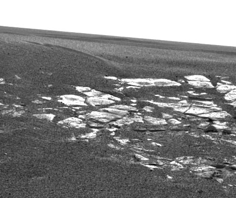
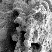
Обнажённые слоистыe скальные породы представляют не меньший интерес, чем грунт. Один из первых снимков с места посадки Opportunity (снимок с сайта jpl.nasa.gov). |
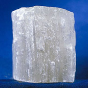
В таких гипсовых кристаллах, недавно найденных на Марсе, вполне могут оказаться органические молекулы из далёкого прошлого планеты (фото с сайта sciencenow.sciencemag.org). |
«Горшок с золотом» (фото с сайта jpl.nasa.gov). Spirit обнаружил на Columbia Hills гематит, марсоход изучил скалу Pot of Gold, снова обнаружил гематит и странные минералы. На другом конце планеты Opportunity продолжал спуск в глубокий кратер Endurance. Здесь также есть любопытные открытия. По составу солей, обнаруживаемых в глубинe кратерa, сделали вывод о подобии между породами в Endurance и грунтом наверху. «Я думал, что мы увидим только базальт ниже главного солёного слоя, но вместо этого — тут всё больше сульфатов, что увеличивает количество воды, которая была необходима, чтобы сформировать когда-то эти слои», — заявил Steve Squyres - http://www.membrana.ru/particle/7101 |
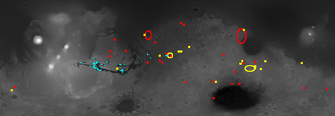
Mikki Osterloo (University of Hawaii) и др. нашли россыпь хлоридов благодаря спутнику Mars Odyssey и вычислили в южном полушарии Марса около 200 участков, покрытых хлоридами. Это могут быть разные соединения (хлорид натрия, хлорид магния и т. д). Поскольку участки представляют низины с каналами, идущими к ним, предполагают, что данные отложения происходят от солёных озёр, некогда испарившихся, либо от участков местности, подвергшихся воздействию грунтовых вод. И пусть по размеру эти «пятна» не так уж велики, они широко разбросаны по всему полушарию. Возраст найденных отложений оценивают в 3500-3900 MA. Tакие залежи являются прекрасными «консервами», в которых могли сохраниться останки былой жизни - http://www.sciencemag.org/content/319/5870/1651.abstract. Участки с хлоридами (на этом фрагменте спутникового изображения они показаны синим), как сообщают учёные, насчитывают площадь от 1 до 25 квадратных километров каждый (M.Osterloo/NASA/JPL-Caltech/ASU/U of Hawaii). |
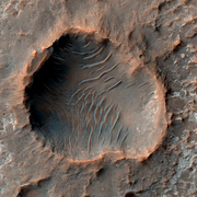
Пока что безымянный кратер в Terra Cimmeria (фото NASA/JPL/University of Arizona).Oтложения солей на дне марсианского кратера обнаружил аппарат Mars Reconnaissance Orbiter. Неожиданный кадр сделан во время полёта над Киммерийской Землёй — Terra Cimmeria — испещрённой кратерами возвышенности на южном полушарии Марса. Отложения были замечены в частично засыпанном кратере. Они покрывают его неравномерным из-за эрозии слоем небольшой толщины - возраст этих минералов очень большой. Находки подобных осадочных пород убеждают в том, что в прошлом на Марсе были условия для длительного существования воды. Многоугольные разломы, которые замечены на поверхности в этом кратере (как и во многих других районах планеты), свидетельствуют, что эти отложения сформировались в результате высыхания. |
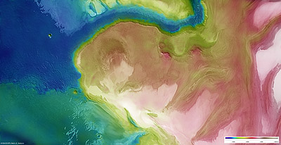
Карта Марса. Богатые залежи глин (красный цвет), сульфатов (синий) и других водных минералов (жёлтый) показаны по результатам последних съёмок европейского аппарата Mars Express (иллюстрация IAS/OMEGA/ESA).Dанные орбитального аппарата Mars Express позволили составить минеральные карты Марсa. Карты показывают, что Марс прошёл в своей истории три эры ( богатый водой мир, кислaя средa после периода активного вулканизма, период длительной заморозки). признаки жизни - на участках, где на поверхность выставлены самые древние полезные ископаемые. Команда инфракрасного спектрометра OMEGA под руководством Жана-Пьера Бибрена (Jean-Pierre Bibring) из французского астрофизического института (Institut d’Astrophysique Spatiale) нашла приблизительно две дюжины участков, богатых глинами, которые формируются в воде и в условиях низкой кислотности. |
Левое изображение показывает область Marwth Vallis на «снимке» (это данные с лазерного альтиметра) американского аппарата Mars Global Surveyor. Справа: тот же участок с добавлением «минеральных» данных, с прибора OMEGA спутника Mars Express. Гидратные полезные ископаемые найдены не на дне канала (синяя стрелка), как можно было бы ожидать, но в разрушенных его берегах и покрытом кратерами плато (красная стрелка) (иллюстрация IAS/OMEGA/ESA |
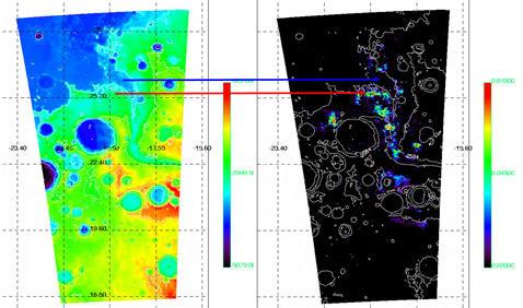
Ha 90% площади Марса участки, богатые глинами, рассеяны по всей планете. Причём обнаружены они в древних кратерах, где лежащий выше слой вулканического пепла, лавы, а также принесённых ветром песка и пыли, был удалён при ударах «небесных скал». Это предполагает, что глины возникли в ранней истории планеты и были сформированы в очень крупном масштабе. Прибор OMEGA нашёл сульфаты и минералы, богатые железными оксидами, эти три класса минералов — следы трёх различных эпох.
В этой картине ещё предстоит многое уточнить, но пока она выглядит следующим образом.
В течение первых 600 миллионов лет из своей 4600 MA Марс, вполне возможно, имел более плотную атмосферу и большие массы воды на поверхности, которая и помогла создать глины.
Эту благоприятную для жизни эру тепла и влаги («расцветавшую» примерно 4,5–4,2 миллиарда лет назад) учёные назвали phyllosian.
Повышение температуры, которое было вызвано распадом радиоизотопов в недрах Марса, привело к периоду активного вулканизма (эра theiikian: 4,2–3,8 миллиарда лет назад).
Поверхность планеты покрыли потоки лавы. Также вулканы выбросили в атмосферу газы, богатые серой, которая, прореагировав с влагой в атмосфере, произвела дожди из серной кислоты, повлиявшей на состав тех мест, где они выпадали. Эта катастрофа навсегда изменила климат планеты.
Грунтовые воды, взаимодействующие с кислой средой, сформировали сульфатные полезные ископаемые, на что ушло приблизительно 500 миллионов лет
http://www.membrana.ru/particle/10725
http://marsprogram.jpl.nasa.gov/mro/ - Video from Mars Reconnaissance Orbiter.
http://www.nasa.gov/mission_pages/MRO/news/mro20110804.html - NASA Spacecraft Data Suggest Water Flowing on Mars
http://www.sciencemag.org/content/329/5997/1334.abstract - Stable Isotope Measurements of Martian Atmospheric CO2 at the Phoenix Landing Site. Paul B. Niles, William V. Boynton, John H. Hoffman, Douglas W. Ming and Dave Hamara
http://www.membrana.ru/particle/415
http://www.membrana.ru/particle/13557
http://www.membrana.ru/particle/7660
http://www.membrana.ru/particle/9447
http://www.membrana.ru/particle/6552
http://www.membrana.ru/particle/13028
http://marsrovers.jpl.nasa.gov/home/index.html !!!
http://www.membrana.ru/particle/15930 mercury
http://www.membrana.ru/particle/15984
http://www.membrana.ru/particle/13053
http://www.membrana.ru/particle/4554
http://www.membrana.ru/particles/tag/944
http://www.membrana.ru/particle/338
http://www.membrana.ru/particle/4433
http://www.membrana.ru/particle/14404
http://www.membrana.ru/particle/14415 -
http://www.membrana.ru/particle/415
http://www.membrana.ru/particle/12738
http://www.membrana.ru/particle/12875
http://www.membrana.ru/particle/12850
http://www.membrana.ru/particle/13172
http://www.membrana.ru/particle/713
http://www.membrana.ru/particle/9348
http://www.membrana.ru/particle/13434
http://www.membrana.ru/particle/8023
http://www.membrana.ru/particle/8282
http://www.membrana.ru/particle/9093
http://www.membrana.ru/particle/415
http://www.membrana.ru/particle/12738
http://www.membrana.ru/particle/13205
http://www.membrana.ru/particle/14186
http://www.membrana.ru/particle/13533
http://www.membrana.ru/particle/13557
http://www.membrana.ru/particle/415
http://www.membrana.ru/particle/13375
http://www.membrana.ru/particle/13533
http://www.membrana.ru/particle/2967
http://www.membrana.ru/particle/12875 perxloriti).
http://www.membrana.ru/particle/10940
http://www.membrana.ru/particle/5032
http://www.membrana.ru/particle/11962
http://www.membrana.ru/particle/13258
http://www.membrana.ru/particle/11932
http://www.membrana.ru/particle/11595
http://www.membrana.ru/particle/11885
http://www.membrana.ru/particle/9447
http://www.membrana.ru/particle/12850
http://www.membrana.ru/particle/13363 -titan
http://www.membrana.ru/particle/12875
http://www.membrana.ru/particle/7983
http://www.membrana.ru/particle/7977
http://www.membrana.ru/particle/7101
http://www.membrana.ru/particle/6605
http://www.membrana.ru/particle/9447
http://www.membrana.ru/particle/9451
http://www.membrana.ru/particle/6292
http://www.membrana.ru/particle/9680
http://www.membrana.ru/particle/9946
http://www.membrana.ru/particle/12170
http://www.membrana.ru/particle/12143 venera
http://sio.ucsd.edu/
http://www.membrana.ru/particle/11425
http://www.membrana.ru/particle/6605
http://www.membrana.ru/particle/11565
http://www.membrana.ru/particle/522 zemila
http://www.membrana.ru/particle/11885 diri
http://www.membrana.ru/particle/622 tresini
http://www.membrana.ru/particle/6499
http://www.membrana.ru/particle/415 more
http://www.esa.int/export/SPECIALS/Mars_Express/SEMUGI2XFVG_0.html - Mountains and buried ice on Mars
http://www.sciencemag.org/content/319/5870/1651.abstract -Chloride-Bearing Materials in the Southern Highlands of Mars. M.M. Osterloo and all.
http://en.wikipedia.org/wiki/Terra_Cimmeria - Terra Cimmeria
http://www.esa.int/esa-mmg/mmg.pl?mission=Mars+Express&keyword=+--%3E+Keyword&idf=+--%3E+ID&Ic=on&subm3=GO – Mars express images
http://www.esa.int/esa-mmg/mmg.pl?b=b&type=I&mission=Mars%20Express&single=y&start=39
http://www.esa.int/esa-mmg/mmg.pl?b=b&type=I&mission=Mars%20Express&single=y&start=91
http://www.membrana.ru/particle/622 tresini
http://www.membrana.ru/particle/6499
http://www.membrana.ru/particle/415 more
http://www.esa.int/export/SPECIALS/Mars_Express/SEMUGI2XFVG_0.html - Mountains and buried ice on Mars
http://www.sciencemag.org/content/319/5870/1651.abstract -Chloride-Bearing Materials in the Southern Highlands of Mars. M.M. Osterloo and all.
http://en.wikipedia.org/wiki/Terra_Cimmeria - Terra Cimmeria
http://www.esa.int/esa-mmg/mmg.pl?mission=Mars+Express&keyword=+--%3E+Keyword&idf=+--%3E+ID&Ic=on&subm3=GO – Mars express images
http://www.agu.org/meetings/fm06/ -agu
Потом произошло вот что: Марс потерял большую долю своей атмосферы. Именно в течение последней части этой «кислой эры», когда внутренности «Бога войны» прекратили генерировать глобальное магнитное поле, а вулканизм – уже утих.
С этого момента солнечный ветер получил возможность беспрепятственно врезаться в атмосферу, фактически «сдув» её. А потеря большей части газовой оболочки привела Марс к состоянию «глубокой заморозки». Вода испарилась или превратилась в лёд.
Следующие миллиарды лет Марс оставался в этом состоянии, постепенно становясь всё более красным, поскольку его богатая железом поверхность ржавела, взаимодействуя с атмосферой.
Эту последнюю эру, начавшуюся примерно 3,8-3,5 миллиарда лет назад, учёные назвали siderikian. Она продолжается и поныне.
Имена всех трёх эр образованы от греческих слов для преобладающих полезных ископаемых, сформированных в эти эпохи. Как видим, на заре жизни Марса он вполне мог быть обитаем. Хотя тут ещё остаётся много неясностей. Например – формировались ли глины на дне тёплых открытых водоёмов или в подземных пластах.
Зато можно сказать, что последующие прохладные условия должны были прекрасно сохранить все следы былых биохимических процессов, если таковые там были.
Подробнее разузнать о перспективных для экзобиологов районах поможет американский аппарат Mars Reconnaissance Orbiter, на днях "бросивший якорь" около Красной планеты.
Ведь его спектрометр обладают в 10 раз большим разрешением, чем аналогичный прибор «европейцаhttp://www.membrana.ru/particle/522
next
Explore Mars
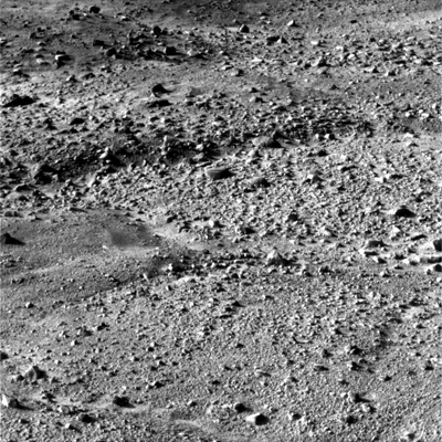
Photos Mars Odyssey
Долины Маринер
Mars Express Images