 | Марс |
Оранжевые шарики карбонатных минералов, найденные в марсианском метеорите ALH84001, послужили прекрасными градусниками (фото NASA).Вычислить условия на поверхности Марса миллиарды лет назад сумели в Caltech. Использованный метод называют «практически прямым определением температуры».В роли свидетеля событий далёкого прошлого выступил метеорит ALH84001 возрастом четыре миллиарда лет.Oн был выбит с поверхности Марса ударом астероида и попал на Землю.ALH84001 помог в климатическом расследовании. Изучив карбонатные минералы в этом метеорите,установили, что они формировались в приповерхностной водной среде при температуре 14-22 °C! Cейчас средняя температура на поверхности планеты составляет минус 63 по Цельсию. Kарбонаты на Марсе могли формироваться несколькими путями (охлаждение магмы, химические реакции в гидротермальных процессах, осаждение из солевых растворов), и во всех – своя, сильно отличная рабочая температура. Чтобы определиться с процессом, команда Калифорнийского технологического института измерила концентрации и соотношение редких изотопов (кислород-18 и углерод-13), содержащихся в карбонатах, а также долю этих элементов, которые сгруппировались.Это и позволило уточнить температуру среды, в которой возникли данные минералы. Найденная температура, в свою очередь, стала доказательством существования жидкой воды, поскольку при 18 градусах другим способом, кроме как из водного раствора, получить найденные в метеорите карбонаты было нельзя. Минералы образовались из воды, которая наполняла крошечные трещины и поры в скалах чуть ниже поверхности. Когда вода испарялась, растворённые вещества наращивали концентрацию. Ряд пород в сочетании с растворёнными ионами создавали карбонаты, водная среда земного типа существовала на Марсе. Добавим, что ранее получали и иные свидетельства присутствия в прошлые эпохи обширных масс жидкой воды практически на всём Марсе. http://www.membrana.ru/particle/15844 |
Одна из предполагаемых марсианских нанобактерий (она по размеру меньше земных), в знаменитом метеорите Аллена Хиллса (Allen Hills ALH 84001) (фото NASA). |
Dетальный анализ топографии, совмещённый с климатическими моделями Марсa показал, что в далёком прошлом северное полушарие покрывал океан, занимавший порядка трети глобуса. Cледы былых морей, наличие залежей льда не только близ полюсов и сам рельеф с ветвистыми долинами — давно подводили к мысли о древнем океане. Однако существует и альтернативная версия создания долин, не нуждающаяся в наличии осадков (она задействует ветровую эрозию и подповерхностные потоки). В последние годы выяснили, что когда-то на Марсе шли дожди. Но не ясно было — насколько они были обильными. Cудя по новой работе, дождей было много и влагу для них поставлял обширный океан, занимавший значительную часть северного полушария планеты. Чтобы установить это,Wei Luo и Tomasz Stepinski создала программу, которая анализировала многочисленные данные о рельефе Марса. Kомпьютер наносил на карту настоящие речные долины, отличающиеся характерной формой. Oбнаружилось, что марсианские долины — более обширны, сложны и ветвисты, чем полагали. Их общая протяжённость в 2,3 раза превосходит прежние оценки, это снимает один из главных вопросов, задаваемых противниками версии о влажном и тёплом Марсе. Дело в том, что если предполагать присутствие северного океана и обильные осадки, выпадающие за счёт перемещения на юг воздушных масс, число и, плотность размещения долин должны быть сравнимыми с таковыми параметрами у Земли. Но если раньше марсианские долины представлялись слишком «бедными», то теперь видно — их там гораздо больше и занимают они целый пояс, проходящий через всю планету примерно в районе экватора. Средняя высота местности в южном полушарии заметно больше (там гористый рельеф), чем в северном (где преобладают низменности), — потому в последнем и скапливалась вода. Испарившаяся влага путешествовала к югу, где выпадала осадками, создающими мощные потоки, сбегавшие «под уклон» — обратно на север. До глубин южного полушария вода почти не доходила, и этим объясняется практическое отсутствие там долин - http://www.agu.org/pubs/crossref/2009/2009JE003357.shtml |
This image shows a ground-range projection of the ‘radargram’ obtained by the MARSIS sounding radar on board ESA’s Mars Express on 6 July 2005 (orbit 1892), when the spacecraft was flying over the Martian lowland plains of Chryse Planitia. Rim walls and interior ring structures of impact basins produce parabolic-shaded echoes. The inset shows that parabolic-shaped echoes in the radargram project to circular arcs, indicating the presence of a buried impact basin http://www.esa.int/esa-mmg/mmg.pl?b=b&type=I&mission=Mars%20Express&single=y&start=336&size=b |
This image shows the locations of the buried basins detected by the MARSIS sounding radar on board ESA’s Mars Express in July 2005. Locations and inferred diameters from MARSIS echoes are shown in black on a MOLA colour-coded shaded relief. The locations and diameters of quasi-circular topographic depressions with diameters larger than 200 kilometres are plotted in white. White polygons show the area covered by MARSIS orbits. Where there is left/right ambiguity in the location of a MARSIS basin that coincides with a quasi-circular topographic depression, the plotted location reflects the minimum offset between the centres of the MARSIS basin and the quasi-circular topographic depressions themselves. http://www.esa.int/esa-mmg/mmg.pl?b=b&type=I&mission=Mars%20Express&single=y&start=337&size=b |
Subsurface echoes from buried basins. LEFT: (Top) This radargram obtained thanks to data form the MARSIS sounding radar on board ESA’s Mars Express on 4 July 2005 (orbit 1886), showing parabolic-shaped echoes from the rim walls of a buried impact basin. (Bottom) The parabolic echoes project to circular arcs on the surface and indicate the location of a 210 km-diameter impact basin in Amazonis Planitia buried by young lava flows. The dashed white circles are approximate fits to the arcs (echoes labelled in the radargrams). The echoes are interpreted to be from the top and bottom rim wall of the basin. RIGHT: (Top) This MARSIS radargram was obtained thanks to data gathered on 7 July 2005 (orbit 1897) and shows a parabolic-shaped echo from the rim wall of a buried impact basin. (Bottom) The surface projection of the parabolic echo indicates a 140 km-diameter basin in Amazonis Planitia buried by young lava flows. The dashed white circles are approximate fits to the arcs (echoes labelled in the radargrams). The echoes are interpreted to be from the far rim wall of the basin. The best fit to the echo indicates that the orbit track is offset from the basin centre, thus the left/right ambiguity in the data does not allow a unique determination of the basin centre. The two bottom images show the subsurface echoes projected on MOLA colour-coded shaded relief. http://www.esa.int/esa-mmg/mmg.pl?b=b&type=I&mission=Mars%20Express&single=y&start=338&size=b , http://www.esa.int/esa-mmg/mmg.pl?b=b&type=I&mission=Mars%20Express&start=29 |
This topographic map, based on Mars Orbiter Laser Altimeter data, shows the MARS Express groundtracks and the arc structures detected by MARSIS that are interpreted to be part of a buried impact basin about 250 km in diameter. The topographic relief represented in the image is 1 km, from low (purple) to high (red). The projected arcs are shown in red for orbit 1892 and white for orbit 1903. There is no obvious feature in the surface topography that corresponds to the buried feature identified with MARSIS data. http://www.esa.int/esa-mmg/mmg.pl?b=b&type=I&mission=Mars%20Express&single=y&start=440&size=b |
This map shows the regions of Granicus Valles and Tinjar Valles, lying at approximately 26.8° North and 135.7° East. The northwest-aligned Granicus Valles and Tinjar Valles are part of the Utopia-Planitia region, an area thought to be covered by a layer of lava that flowed from the northwest flanks of Elysium Mons into the Utopia-Planitia Basin. |
This is a mosaic of Olympus Mons, the highest volcano on Mars, which towers 26 km above the surrounding plains. The image covers an area of approximately 600 000 sq km and is colour-coded according to height based on data from the Digital Terrain Model (DTM). The High Resolution Stereo Camera (HRSC) on board ESA’s Mars Express orbiter imaged the region over 18 orbits. This image is an ortho-image mosaic, where the projecting rays are perpendicular to the plane of projection. This corrects any deformations introduced by an imaging camera. Such an image can be fitted directly on to a map. http://www.esa.int/esa-mmg/mmg.pl?b=b&type=I&mission=Mars%20Express&single=y&start=280&size=b |
The image shows the western flank of the shield volcano Olympus Mons in the Tharsis region of the western Martian hemisphere. The escarpment at lower left rises from the surface level to over 7000 metres. At the top of the image, part of the extensive plains west of the escarpment are shown, known as the ''aureole'' (from the Latin for ''circle of light'').To the north and west of the volcano, these ''aureole'' deposits are regions of gigantic ridges and blocks extending some 1000 kilometres from the summit like petals of a flower. The origin of the deposits has challenged planetary scientists for an explanation for decades. The most persistent explanation, however, has been landslides. Large masses of shield material can be found in the aureole area. Several indications also suggest a development and resurfacing connected to glacial activity.http://www.esa.int/esa-mmg/mmg.pl?b=b&type=I&mission=Mars%20Express&single=y&start=622&size=b |
This perspective view of the caldera of the Olympus Mons volcano on Mars has been calculated from the digital elevation model derived from the stereo channels and combined with the nadir and colour channels of the HRSC.http://www.esa.int/esa-mmg/mmg.pl?b=b&type=I&mission=Mars%20Express&single=y&start=591&size=b |
This close-up perspective view, looking south-west, shows the eastern scarp of the Olympus Mons volcano. The HRSC obtained this image on 23 November 2004 during orbit 1089 with a ground resolution of approximately 11 metres per pixel. The image is centred at 17.5° North and 230.5° East http://www.esa.int/esa-mmg/mmg.pl?b=b&type=I&mission=Mars%20Express&single=y&start=412&size=b |
Perspective view of eastern scarp of Olympus Mons.The HRSC on ESA''s Mars Express obtained this perspective view on 23 November 2004 during orbit 1089 with a ground resolution of approximately 11 metres per pixel. The image is centred at 17.5° North and 230.5° East. This view is looking west. The scarp is up to six kilometres high in places. http://www.esa.int/esa-mmg/mmg.pl?b=b&type=I&mission=Mars%20Express&single=y&start=413&size=b |
A perspective view of a section of the outward-facing scarp surrounding the Olympus Mons volcano, 550 kilometres around and up to six kilometres high in places.This image was taken by the HRSC on ESA''s Mars Express spacecraft during orbit 143 on 24 February 2004.http://www.esa.int/esa-mmg/mmg.pl?b=b&type=I&mission=Mars%20Express&single=y&start=590&size=b |
The images show the topographic divide between the Martian highlands and lowlands. The mysterious deposits of the Medusae Fossae Formation are found in the lowlands along the divide. The radar sounder on ESA''s Mars Express orbiter, MARSIS, has revealed echoes, in the image to the right, from the lowland plains buried by these mysterious deposits http://www.esa.int/esa-mmg/mmg.pl?b=b&type=I&mission=Mars%20Express&single=y&start=293&size=b |
This is an ortho-image of Hebes Chasma, a trough in the Grand Canyon of Mars. The image is overlaid with elevation data from an HRSC-derived high-resolution digital terrain model (DTM). In an ortho-image, the projecting rays are perpendicular to the plane of projection. This corrects any deformations introduced by an imaging camera. Such an image can be fitted directly on to a map. Hebes Chasma is located at approximately 1° south and 282° east. Image data was obtained on 16 September 2005 with a ground resolution of approximately 15 m/pixel http://www.esa.int/esa-mmg/mmg.pl?b=b&type=I&mission=Mars%20Express&start=22. |
Perspective view of Hebes Chasma obtained by the High Resolution Stereo Camera (HRSC) on ESA’s Mars Express spacecraft.Hebes Chasma is located at approximately 1° south and 282° east. The HRSC obtained image data on 16 September 2005 with a ground resolution of approximately 15 m/pixel |
Perspective view of Hebes Chasma |
Promethei Planum, an area seasonally covered with a layer of ice more than 3500 m thick in the martian south polar region, was the subject of the High Resolution Stereo Camera’s (HRSC) focus on 22 September 2005 as Mars Express was in orbit above the Red Planet. Promethei Planum lies at approximately 76° south and 105° east. An approximately 100 km-large and 800 m-deep impact crater is visible in the northern part of the image. The crater’s interior is partly covered in ice. In the centre of the image are structures that may have been created by basaltic lava flow from a volcano. This area is covered in ice. The dark dunes towards the bottom of the image are most likely made up of dust originating from this lava flow or volcanic ash. A broad sheet of ice, which is an extension of the south polar ice cap, is located south of the lava flow, to the left in the (nadir) image. The steep flanks clearly show white, clean ice. The thickness of the ice is between 900 and 1100 m - http://www.esa.int/esa-mmg/mmg.pl?b=b&type=I&mission=Mars%20Express&start=23 |
Promethei Planum lies at approximately 76° south and 105° east. An approximately 100 km-large and 800 m-deep impact crater is visible in the northern part of the image. The crater’s interior is partly covered in ice. In the centre of the image are structures that may have been created by basaltic lava flow from a volcano. This area is covered in ice. The dark dunes towards the bottom of the image are most likely made up of dust originating from this lava flow or volcanic ash. A broad sheet of ice, which is an extension of the south polar ice cap is located south of the lava flow, to the left in the (nadir) image. The steep flanks clearly show white, clean ice. The thickness of the ice is between 900 and 1100 m. http://www.esa.int/esa-mmg/mmg.pl?b=b&type=I&mission=Mars%20Express&single=y&start=266&size=b |
Promethei Planum, an area seasonally covered with a layer of ice more than 3500 m thick layer of ice in the martian south polar region, was the subject of the High Resolution Stereo Camera’s (HRSC) focus on 22 September 2005 as Mars Express was in orbit the Red Planet. Promethei Planum lies at approximately 76° south and 105° east. http://www.esa.int/esa-mmg/mmg.pl?b=b&type=I&mission=Mars%20Express&single=y&start=267&size=b |
Mars Express took snapshots of Candor Chasma, a valley in the northern part of Valles Marineris, as it was in orbit above the region on 6 July 2006. The High Resolution Stereo Camera on the orbiter obtained the data in orbit number 3195, with a ground resolution of approximately 20 m/pixel. Candor Chasma lies at approximately 6° south and 290° east. Valles Marineris is an approximately 3000-km-long canyon system on Mars. Candor Chasma, situated in its northern part, is part of a radial graben system. A graben is a feature bound by parallel normal faults, where the graben floor moves downward relative to the adjoining material. The grabens in the area were created radially, as the Tharsis bulge formed due to volcanic uplift. http://www.esa.int/esa-mmg/mmg.pl?b=b&type=I&mission=Mars%20Express&start=23 |
Mars Express took snapshots of Candor Chasma, a valley in the northern part of Valles Marineris, as it was in orbit above the region on 6 July 2006. The High Resolution Stereo Camera on the orbiter obtained the data in orbit number 3195, with a ground resolution of approximately 20 m/pixel. Candor Chasma lies at approximately 6° south and 290° east. http://www.esa.int/esa-mmg/mmg.pl?b=b&type=I&mission=Mars%20Express&single=y&start=275&size=b |
Mars Express took snapshots of Candor Chasma, a valley in the northern part of Valles Marineris, as it was in orbit above the region on 6 July 2006. The High Resolution Stereo Camera on the orbiter obtained the data in orbit number 3195, with a ground resolution of approximately 20 m/pixel. Candor Chasma lies at approximately 6° south and 290° east. http://www.esa.int/esa-mmg/mmg.pl?b=b&type=I&mission=Mars%20Express&single=y&start=276&size=b |
This is an image of Daedalia Planum, located 1000 km south of Arsia Mons, a southern volcano of the Tharsis Montes. The image was taken on 19 July 2005, from a distance of 302 km from the surface. The image is centred at 235.4° east and 26.2° south. The scene spans a width of 100 km and the ground resolution is 25 m/pixel. http://www.esa.int/esa-mmg/mmg.pl?b=b&type=I&mission=Mars%20Express&single=y&start=265&size=b |
This image taken by the High Resolution Stereo Camera (HRSC) on board Mars Express shows the mouth of the Tiu Valles channel system. The picture was taken in orbit 3103 on 10 June 2006 with a ground resolution of approximately 16 metres per pixel. The region is located at approximately 27° North and 330° East. Its winding, meandering ridges, bound by depressions are eye-catching. The processes that formed these odd structures are unknown. Possibly, during floods events, water or water-rich surface layers came in contact with lava from the surrounding areas, which then might have led to the formation of these mysterious ridges http://www.esa.int/esa-mmg/mmg.pl?b=b&type=I&mission=Mars%20Express&single=y&start=303&size=b |
This image of Terby crater was derived from three HRSC colour channels and the nadir channel of the High Resolution Stereo Camera (HRSC) on board ESA’s Mars Express orbiter. The Terby crater region is of great scientific interest as sediments there hold information on the role of water in the history of the planet. The image data was obtained on 13 April 2007 during orbit 4199, with a ground resolution of approximately 13 m/pixel. The Sun illuminates the scene from the west (from above in the image). Terby crater lies at approximately 27° south and 74° east. It is located at the northern edge of the Hellas Planitia impact basin in the southern hemisphere of Mars. The crater, named after the Belgian astronomer Francois J. Terby (1846 – 1911), has a diameter of approximately 170 km. The scene shows a section of a second impact crater in the northern part of Terby crater. http://www.esa.int/esa-mmg/mmg.pl?b=b&type=I&mission=Mars%20Express&start=24 |
Eye-catching finger-shaped plateaux extend in the north-south direction (1). They rise up to 2000 m above the surrounding terrain. The relatively old crater was filled with sediments in the past, which formed plateaux on erosion. The flanks of the plateaux clearly exhibit layering of different-coloured material (2). Differences in colour usually indicate changes in the composition of the material and such layering is called ‘bedding’. Bedding structures are typical of sedimentary rock, which has been deposited either by wind or water. Different rock layers erode differently, forming terraces (3). The valleys (4) exhibit gullies, or channels cut in the ground by running liquid, mainly in the northern part of the image. These gullies and the rock-bedding structure indicate that the region has been affected by water. http://www.esa.int/esa-mmg/mmg.pl?b=b&type=I&mission=Mars%20Express&single=y&start=283&size=b |
The High Resolution Stereo Camera (HRSC) on board ESA’s Mars Express orbiter imaged the Terby crater on Mars on 13 April 2007 during orbit 4199. The region is of great scientific interest as sediments there reveal information on the role of water in the history of the planet. Eye-catching finger-shaped plateaux extend in the north-south direction. They rise up to 2000 m above the surrounding terrain. The relatively old crater was filled with sediments in the past, which formed plateaux on erosion. The flanks of the plateaux clearly exhibit layering of different-coloured material. Differences in colour usually indicate changes in the composition of the material and such layering is called ‘bedding’. Bedding structures are typical of sedimentary rock, which has been deposited either by wind or water. Different rock layers erode differently, forming terraces. The valleys exhibit gullies, or channels cut in the ground by running liquid, mainly in the northern part of the image. These gullies and the rock-bedding structure indicate that the region has been affected by water http://www.esa.int/esa-mmg/mmg.pl?b=b&type=I&mission=Mars%20Express&single=y&start=285&size=b |
The High Resolution Stereo Camera (HRSC) on board ESA’s Mars Express orbiter imaged the Terby crater on Mars on 13 April 2007 during orbit 4199. The region is of great scientific interest as sediments there hold information on the role of water in the history of the planet. Eye-catching finger-shaped plateaux extend in the north-south direction. They rise up to 2000 m above the surrounding terrain. The relatively old crater was filled with sediments in the past, which formed plateaux on erosion. The flanks of the plateaux clearly exhibit layering of different-coloured material. Differences in colour usually indicate changes in the composition of the material and such layering is called ‘bedding’. Bedding structures are typical of sedimentary rock, which has been deposited either by wind or water. Different rock layers erode differently, forming terraces. The valleys exhibit gullies, or channels cut in the ground by running liquid, mainly in the northern part of the image. These gullies and the rock-bedding structure indicate that the region has been affected by water. http://www.esa.int/esa-mmg/mmg.pl?b=b&type=I&mission=Mars%20Express&single=y&start=284&size=b |
This image was taken by the High-Resolution Stereo Camera (HRSC), onboard ESA’s Mars Express imaged the Noctis Labyrinthus region, the ‘Labyrinth of the Night’ on Mars. The HRSC took these pictures on 25 June 2006 in orbit 3155, with a ground resolution of approximately 16 m/pixel. This colour scene has been derived from the three HRSC colour channels and the nadir channel. http://www.esa.int/esa-mmg/mmg.pl?b=b&type=I&mission=Mars%20Express&single=y&start=288&size=b |
This image was taken by the High-Resolution Stereo Camera (HRSC), onboard ESA’s Mars Express imaged the Noctis Labyrinthus region, the ‘Labyrinth of the Night’ on Mars. The HRSC took these pictures on 25 June 2006 in orbit 3155, with a ground resolution of approximately 16 m/pixel. http://www.esa.int/esa-mmg/mmg.pl?b=b&type=I&mission=Mars%20Express&single=y&start=289&size=b |
This perspective view of the Noctis Labyrinthus region, the ‘Labyrinth of the Night’ on Mars was obtained with data from the High-Resolution Stereo Camera (HRSC), onboard ESA’s Mars Express |
Tectonic transition zone, Aeolis Mensae - Mars Express’ High Resolution Stereo Camera (HRSC) has provided snapshots of the Aeolis Mensae region on the Red Planet. This area, well-known for its features that reflect the result of the activity of wind on the arid planet, lies on a tectonic transition zone, characterised by incised valleys and unexplained linear features. Illuminated by the Sun from the west (right hand side in the image), the pictures are of a ground resolution of approximately 13 meters per pixel. The region, imaged on 26 and 29 March 2007, during Mars Express orbit number 4136 and 4247, is located at approximately 6° South and 145° East. http://www.esa.int/esa-mmg/mmg.pl?b=b&type=I&mission=Mars%20Express&single=y&start=312&size=b |
Aeolis Mensae North, perspective view - Mars Express’ High Resolution Stereo Camera (HRSC) has provided snapshots of the Aeolis Mensae region on the Red Planet. The region, imaged on 26 and 29 March 2007, during Mars Express orbit number 4136 and 4247, is located at approximately 6° South and 145° East. Deep valleys are incised into the highlands in the northern part of the scene showing linear features on the floor of the valley. Similar linear features are also seen in the lower part of the picture but the morphology is different from the region in the upper part in that there are no incisions. Also, the area is far less cratered and hence the erosion must be of a relatively recent origin. Scientists have reason to believe that the valleys might primarily originate from tectonic activity, possibly also modelled locally by subsequent fluid or mass wasting activity. http://www.esa.int/esa-mmg/mmg.pl?b=b&type=I&mission=Mars%20Express&start=27 |
Aeolis Mensae South, anaglyph image - Mars Express’ High Resolution Stereo Camera (HRSC) has provided snapshots of the Aeolis Mensae region on the Red Planet. The region, imaged on 26 and 29 March 2007, during Mars Express orbit number 4136 and 4247, is located at approximately 6° South and 145° East. The morphology of the terrain, which lies close to the volcanic region of Elysium, is characterised by an extensive transition zone or the so-called ‘global crustal dichotomy boundary’ which separates the southern highlands and northern lowlands. It exhibits clod-shaped or lumpy relief separated by valleys and intermediated graben features, or elongated, trench-like structures, which are eroded landforms. Aeolis Mensae is located at the border of the northern plains and the southern highlands, indicated by the transition zone. Between the highlands and the plains there is a large average difference in elevation, of about 3000 metres. The origin of this dichotomy is currently a subject of discussion. http://www.esa.int/esa-mmg/mmg.pl?b=b&type=I&mission=Mars%20Express&single=y&start=318 |
Original ''Face on Mars'' image taken by NASA''s Viking 1 orbiter, in grey scale, on 25 July 1976. Image shows a remnant massif located in the Cydonia region. On 31 July 1976, a NASA press release said the formation "resembles a human head." However, NASA scientists had already correctly interpreted the image as an optical illusion caused by the illumination angle of the Sun, the formation''s surface morphology and the resulting shadows, giving the impression of eyes, nose and mouth. http://www.esa.int/esa-mmg/mmg.pl?b=b&type=I&mission=Mars%20Express&single=y&start=348&size=b |
A perspective view showing the so-called ''Face on Mars'' located in the Cydonia region. The image shows a remnant massif thought to have formed via landslides and an early form of debris apron formation. The massif is characterized by a western wall that has moved downslope as a coherent mass. The massif became famous as the ''Face on Mars'' in a photo taken on 25 July 1976 by the American Viking 1 Orbiter. Image recorded during orbits 3253 and 1216 by the High Resolution Stereo Camera (HRSC) on board ESA''s Mars Express. Image is based on data gathered over the Cydonia region, with a ground resolution of approximately 13.7 metres per pixel. Cydonia lies at approximately 40.75° North and 350.54° East. http://www.esa.int/esa-mmg/mmg.pl?b=b&type=I&mission=Mars%20Express&single=y&start=347&size=b |
A second perspective view showing the so-called ''Face on Mars'' located in Cydonia region. The image shows a remnant massif thought to have formed via landslides and an early form of debris apron formation. The massif is characterized by a western wall that has moved downslope as a coherent mass. The massif became famous known as the ''Face on Mars'' in a photo taken on 25 July 1976 by the American Viking 1 Orbiter |
A colour perspective view showing a naturally ''skull-shaped'' formation located in Cydonia region. The image shows a remnant massif shaped - at least somewhat - like a skull. Image recorded during orbits 3253 and 1216 by the High Resolution Stereo Camera (HRSC) on board ESA''s Mars Express. Image is based on data were gathered over the Cydonia region, with a ground resolution of approximately 13.7 metres per pixel. Cydonia lies at approximately 40.75° North and 350.54° East. |
A perspective view showing a naturally ''skull-shaped'' and several ''pyramid-shaped'' formations located in the Cydonia region |
The image shows a perspective view of the Southern branch of Kasei Valles looking to the East (the image has been rotated approximately 90 degrees counter-clockwise so that North is to the left). The Southern branch of Kasei Valles and Sacra Mensa, with its 1- to 2-kilometre-deep graben system, Sacra Fossae, can be clearly seen. http://www.esa.int/esa-mmg/mmg.pl?b=b&type=I&mission=Mars%20Express&single=y&start=360&size=b |
Iani Chaos is one of many regions east of Valles Marineris characterized by disrupted or chaotic terrain. The morphology of this terrain is dominated by large-scale remnant massifs, which are large relief masses that have been moved and weathered as a block. These are randomly oriented and heavily eroded. To the south (south is to the left) in this image, these mesas, which appear as flat-topped hills, range from less than one kilometre to roughly 8 kilometres wide, with a maximum relative elevation of approximately 1000 metres. http://www.esa.int/esa-mmg/mmg.pl?b=b&type=I&mission=Mars%20Express&single=y&start=369&size=b |
Aram Chaos, perspective view. This perspective view is based on data captured on 14 October 2004 by the High-Resolution Stereo Camera (HRSC) onboard the ESA spacecraft Mars Express with a ground resolution of approximately 14 metres per pixel. Colour scenes were derived from the three HRSC colour channels and the nadir channel, while the perspective view was calculated from the digital terrain model derived from the stereo channels. http://www.esa.int/esa-mmg/mmg.pl?b=b&type=I&mission=Mars%20Express&single=y&start=380&size=b |
Lava tubes on Pavonis Mons, in perspective. This perspective view, taken by the High Resolution Stereo Camera (HRSC) on board ESA''s Mars Express, shows Pavonis Mons, the central volcano of the three ''shield'' volcanoes that comprise Tharsis Montes. ESA''s Mars Express spacecraft obtained this image using the HRSC during orbit 902 on 2 October 2004 with a ground resolution of approximately 14.3 metres per pixel. http://www.esa.int/esa-mmg/mmg.pl?b=b&type=I&mission=Mars%20Express&single=y&start=383&size=b |
Pavonis Mons in Tharsis Montes, This image, taken by the High Resolution Stereo Camera (HRSC) on board ESA''s Mars Express, shows Pavonis Mons, the central volcano of the three ''shield'' volcanoes that comprise Tharsis Montes. ESA''s Mars Express spacecraft obtained these images using the HRSC during orbit 902 on 2 October 2004 with a ground resolution of approximately 14.3 metres per pixel. The images were acquired in the region of Pavonis Mons, at approximately 0.6° South and 246.4° East. Pavonis Mons, rising roughly 12 km above the surrounding plains, is the central volcano of the three ''shield'' volcanoes that comprise Tharsis Montes. Gently sloping shield volcanoes are shaped like a flattened dome and are built almost exclusively of lava flows. The dramatic features visible in the colour image are located on the south western flank of the volcano. Researchers believe these are lava tubes, channels originally formed by hot, flowing lava that forms a crust as the surface cools. Lava continues to flow beneath this hardened surface, but when the lava production ends and the tunnels empty, the surface collapses, forming elongated depressions. Similar tubes are well known on Earth and the Moon. Pit chains, strings of circular depressions thought to form as the result of collapse of the surface, are also visible within the colour image http://www.esa.int/esa-mmg/mmg.pl?b=b&type=I&mission=Mars%20Express&single=y&start=382&size=b |
The caldera of Apollinaris Patera, an ancient, 5-kilometre-high volcano northwest of Gusev Crater. In this true-colour image, the terrain is partly covered by thin, diffuse, whitish-appearing clouds. North is to the right.-http://www.esa.int/esa-mmg/mmg.pl?b=b&type=I&mission=Mars%20Express&single=y&start=374&size=b |
Grabens’ in Tempe Terra, a geologically complex region that is part of the old Martian highlands. Grabens are depressed blocks of land bordered by parallel faults, and have tectonic origin. The valleys and grabens are 5 to 10 kilometres wide and up to 1500 meters deep. Along the graben flanks, the layering of the bedrock is exposed. Tectonic processes have led to the development of these grabens. After the tectonic activity, other processes reshaped the landscape. In the scene, the results of weathering and mass transport can be seen. Due to these processes, the surface has been smoothed, giving formerly sharp edges a rounded appearance. The Tempe Terra region of Mars displays a complex geologic history; the image was taken just west of the Barabashov crater and covers the transition zone between the old Martian highlands to the south and the geologically younger northern lowlands. The HRSC camera on board ESA’s Mars Express obtained these images during orbit 1180 on 19 December 2004 with a ground resolution of approximately 16.5 metres per pixel. The data were acquired in the region of Northern Olympus Mons, at approximately 48.5° North and 288.4° East. http://www.esa.int/esa-mmg/mmg.pl?b=b&type=I&mission=Mars%20Express&single=y&start=386&size=b |
Libya Montes valley region.The image shows the central reaches of a 400-kilometre long valley that was carved into the surface in early Martian history, approximately 3500 million years ago http://www.esa.int/esa-mmg/mmg.pl?b=b&type=I&mission=Mars%20Express&single=y&start=403&size=b |
Perspective view of Libya Montes valley, looking east - http://www.esa.int/esa-mmg/mmg.pl?b=b&type=I&mission=Mars%20Express&start=34 |
Perspective view, looking west of the crater behind the ''hourglass'' craterThe unusual ''hourglass''-shaped structure, seen here in the background, is located in the southern-hemisphere highland terrain of Promethei Terra at the eastern rim of the Hellas Basin, at about latitude 38є South and longitude 104є East. http://www.esa.int/esa-mmg/mmg.pl?b=b&type=I&mission=Mars%20Express&single=y&start=404&size=b |
The unusual ''hourglass''-shaped structure, seen here at the top of the image, is located in the southern-hemisphere highland terrain of Promethei Terra at the eastern rim of the Hellas Basin, at about latitude 38є South and longitude 104є East |
The scene shows the region of Hellas Planitia, about 234 kilometres wide in the north and 345 kilometres wide in the south, about 898 kilometres in length, and centred approximately at 89° East and 29° South. The image represents an area on the northern eastern rim of Hellas Planitia, also known as the Hellas impact basin in Mars''s southern hemispere. The basin is thought to have formed around 3900 million years ago in a single massive impact http://www.esa.int/esa-mmg/mmg.pl?b=b&type=I&mission=Mars%20Express&single=y&start=407&size=b |
Fractures of Claritas Fossae. The scene shows the region of Claritas Fossae, about 150 kilometres wide in the north and 550 kilometres wide in the south, about 1200 kilometres in length, and centred approximately at 253° East and 32° South. The linear fractures of Claritas Fossae have widths ranging from a few kilometres to 100 kilometres. This is a high-resolution image of the Claritas Fossae region on Mars, further to the one which was published on 31 March 2004. http://sci.esa.int/science-e/www/object/index.cfm?fobjectid=38671 |
The scene shows the region of Ismenicus Lacus, about 77 kilometres wide in the north and 63 kilometres wide in the south, about 845 kilometres in length, and centred approximately at 25° East and 40° North. The image represents a transitional region on the surface separating the heavily cratered highlands in the south part and the smooth plains in the north. The dissected terrain contains a series of mesas (isolated high plateau) and buttes (a small flat topped hill). http://sci.esa.int/science-e/www/object/index.cfm?fobjectid=38801 |
This view shows the region of Hesperia Planum, containing the massif, at approximately 30.3° South and 97.8° East.http://www.esa.int/esa-mmg/mmg.pl?b=b&type=I&mission=Mars%20Express&single=y&start=410&size=b |
Perspective view of the Ausonia Mensa massif. The perspective view shows the region of Hesperia Planum, containing the massif, at approximately 30.3° South and 97.8° East. This view is looking south-east. |
This image, taken by the High Resolution Stereo Camera (HRSC) on board ESA’s Mars Express spacecraft, shows pits and tectonic ‘grabens’ in the Phlegethon Catena region of Mars. The HRSC obtained this image on 29 December 2004 during orbit 1217 with a ground resolution of approximately 11.9 metres per pixel. The scene shows the region centred at approximately 33.9° South and 253.1° East. North is to the right. http://www.esa.int/esa-mmg/mmg.pl?b=b&type=I&mission=Mars%20Express&single=y&start=423&size=b |
This oblique perspective view, looking to the north, was taken by the High Resolution Stereo Camera (HRSC) on board ESA’s Mars Express spacecraft, shows pits and tectonic ‘grabens’ in the Phlegethon Catena region of Mars |
This oblique perspective view, looking to the south, was taken by the High Resolution Stereo Camera (HRSC) on board ESA’s Mars Express spacecraft, shows pits and tectonic ‘grabens’ in the Phlegethon Catena region of Mars. |
Perspective view of the ''sulphate'' mountain - looking north-east. Perspective view of the mountain in Juventae Chasma, thought to be composed of sulphates, looking north-east. The HRSC obtained this image on 26 March 2004 during orbit 243 with a ground resolution of approximately 23.4 metres per pixel. The scene shows the region of Lunae Planum, at approximately 5° South and 297° East. http://www.esa.int/esa-mmg/mmg.pl?b=b&type=I&mission=Mars%20Express&single=y&start=427&size=b |
This image taken by the High Resolution Stereo Camera (HRSC) on board ESA’s Mars Express spacecraft, shows the depression of Juventae Chasma, cut into the plains of Lunae Planum on Mars. The HRSC obtained this image on 26 March 2004 during orbit 243 with a ground resolution of approximately 23.4 metres per pixel. The scenes show the region of Lunae Planum, at approximately 5° South and 297° East. North is to the left. In the north-eastern part of the scene, there is a mountain composed of bright, layered material. This mountain is approximately 2500 metres high, 59 kilometres long and up to 23 kilometres wide. http://www.esa.int/esa-mmg/mmg.pl?b=b&type=I&mission=Mars%20Express&single=y&start=430&size=b |
Close-up perspective view of the mountain in Juventae Chasma, thought to be composed of sulphates, looking east. The HRSC obtained this image on 26 March 2004 during orbit 243 with a ground resolution of approximately 23.4 metres per pixel. The scene shows the region of Lunae Planum, at approximately 5° South and 297° East. http://www.esa.int/esa-mmg/mmg.pl?b=b&type=I&mission=Mars%20Express&single=y&start=433&size=b |
This perspective view of the Biblis Patera volcano, looking west, was taken by the High Resolution Stereo Camera (HRSC) on board ESA’s Mars Express spacecraft on 8 November 2004. Biblis Patera is 170 kilometres long, 100 kilometres wide and rises nearly three kilometres above its surroundings. The caldera has a diameter of 53 kilometres and extends to a maximum depth of roughly 4.5 kilometres. The caldera may have been formed as the result of collapse of the magma chamber during eruptions of the volcano, and some of the structures seen in the caldera walls suggest that multiple collapse events have occurred. http://www.esa.int/esa-mmg/mmg.pl?b=b&type=I&mission=Mars%20Express&single=y&start=441&size=b |
The HRSC on board ESA''s Mars Express obtained this image during orbit 1104 around Mars with a ground resolution of approximately 15.3 metres per pixel. This perspective view shows the central part of Nicholson Crater, at approximately 0.0° South and 195.5° East, looking west. Nicholson Crater, measuring approximately 100 kilometres wide, is located at the southern edge of Amazonis Planitia, north-west of a region called Medusae Fossae. http://www.esa.int/esa-mmg/mmg.pl?b=b&type=I&mission=Mars%20Express&single=y&start=449&size=b |
This image, taken by the High Resolution Stereo Camera (HRSC) on board ESA’s Mars Express spacecraft, shows Coprates Chasma, a major trough located roughly in the centre of the Valles Marineris canyon system. The HRSC obtained this perspective view on 28 May 2004 during orbit 449 with a ground resolution of approximately 48 metres per pixel. The scene shows the region of Coprates Chasma and Coprates Catena, over an area centred at about 13.5є South and 300є East, looking north. The main trough, appearing in the north (top half) of this image, ranges from approximately 60 km to 100 km wide and extends 8-9 km below the surrounding plains. Coprates Catena lies parallel to Coprates Chasma and can be seen in the south (lower half) of the image as three smaller troughs, ranging from a few kilometres to 22 km wide and up to 5 km deep http://www.esa.int/esa-mmg/mmg.pl?b=b&type=I&mission=Mars%20Express&single=y&start=461&size=b |
This close-up view of the Martian north polar ice cap shows layers of water ice and dust for the first time in perspective view. Here we see cliffs which are almost 2 kilometres high, and the dark material in the caldera-like structures and dune fields could be volcanic ash http://www.esa.int/esa-mmg/mmg.pl?b=b&type=I&mission=Mars%20Express&single=y&start=478&size=b |
This images, taken by the High Resolution Stereo Camera (HRSC) on board ESA’s Mars Express spacecraft, shows the central part of the 4000-kilometre long Valles Marineris canyon on Mars. The HRSC obtained this image during during orbits 334 and 360, on 24 April and 2 May 2004 respectively, with a resolution of approximately 21 metres per pixel for the earlier orbit and 30 metres per pixel for the latter. The scene shows an area of approximately 300 by 600 kilometres and is created from an image mosaic from the two orbit sequences. The image is located between 3є to 13є South, and 284є to 289є East. North is up. http://www.esa.int/esa-mmg/mmg.pl?b=b&type=I&mission=Mars%20Express&single=y&start=481&size=b |
The HRSC obtained this image of Aureum Chaos during orbit 456 with a resolution of approximately 25 metres per pixel. The scene shows an area located at about 3є South and 335є East. This view is looking north toward the well-defined scarp, and showing ''slump and collapse’ blocks at its base. http://www.esa.int/esa-mmg/mmg.pl?b=b&type=I&mission=Mars%20Express&single=y&start=486&size=b |
This image shows the base of the northern wall (far right of the main black and white image) of Tithonium Chasma. This image was taken during orbit 887 with a ground resolution of approximately 13 metres per pixel. The displayed region is located at about latitude 5° South and longitude 280° East. North is at the top the image http://www.esa.int/esa-mmg/mmg.pl?b=b&type=I&mission=Mars%20Express&single=y&start=508&size=b |
Colour view of Candor Chasma http://www.esa.int/esa-mmg/mmg.pl?b=b&type=I&mission=Mars%20Express&start=43 |
Perspective view of Candor Chasma, looking north-west http://www.esa.int/esa-mmg/mmg.pl?b=b&type=I&mission=Mars%20Express&start=43 |
Perspective view of Coprates Catena, looking west. This perspective view, looking west, was taken by the High Resolution Stereo Camera (HRSC) on board ESA’s Mars Express spacecraft. It shows the detailed structure of Coprates Catena, a southern part of the Valles Marineris canyon system on Mars, http://www.esa.int/esa-mmg/mmg.pl?b=b&type=I&mission=Mars%20Express&single=y&start=526&size=b |
This image, taken by the High Resolution Stereo Camera (HRSC) on board ESA’s Mars Express spacecraft, shows part of the Medusa Fossae formation and adjacent areas at the highland-lowland boundary on Mars. This perspective view, looking south-east, is calculated from the digital terrain model derived from the stereo channels, The HRSC obtained this image during orbit 917 with a resolution of approximately 13 metres per pixel. It shows an area located at about 5є South and 213є East.The Medusa Fossae formation is an extensive unit of enigmatic origin found near the Martian ‘highland-lowland dichotomy boundary’ between the Tharsis and Elysium centres of volcanic activity.http://www.esa.int/esa-mmg/mmg.pl?b=b&type=I&mission=Mars%20Express&start=45 |


next
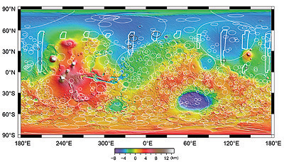
Topographic map of Mars at 1:200 000
More images
точная карта Марса