 | Mendocino |
|
Cascade volcanic arc -http://en.wikipedia.org/wiki/Mendocino_Fracture_Zone |
Cascadia subduction zone -http://en.wikipedia.org/wiki/Cascadia_subduction_zone |
Mendocino |
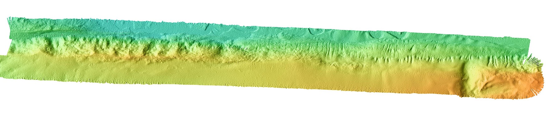
http://www.mbari.org/data/mapping/seamounts/images/MendocinoA.jpg |
http://www.mbari.org/data/mapping/seamounts/mendocino.htm |
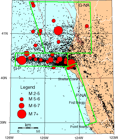
. M2 in northern California coastal region 1985-2003. White lines are major roads. Brown lines are faults active since the Late Quaternary. Labeled green polygons bound regions described in scenario section of text. G-NA= Gorda-North America, G-P= Gorda-Pacific, and P-NA=Pacific North America. http://woodshole.er.usgs.gov/operations/obs/rmobs_pub/html/mendocino.html |
Map of the Mendocino Triple Junction (courtesy of Richard Allen) -http://seismo.berkeley.edu/blogs/seismoblog.php/2008/10/27/where-the-san-andreas-fault-ends |
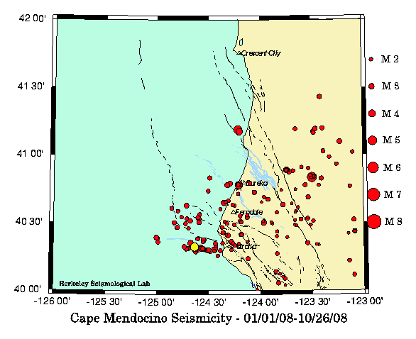
Within just half a minute of each other, two earthquakes shook the northern coastal region of the state. The first temblor, with a magnitude of 3.8, occured at half past two early Sunday morning, October 26th. It was located off-shore, about 35 miles southwest of Eureka. With a magnitude of 4.9, the second quake was considerably stronger and happened virtually in the same spot (yellow dot on the map) 31 seconds later. The second quake was felt widely along the coast from Fort Bragg in the south almost to Crescent City in the north. The foci of both temblors are located within the "Mendocino Triple Junction," where three tectonic plates and several fault lines meet. http://seismo.berkeley.edu/blogs/seismoblog.php/2008/10/27/where-the-san-andreas-fault-ends |
|
|
|
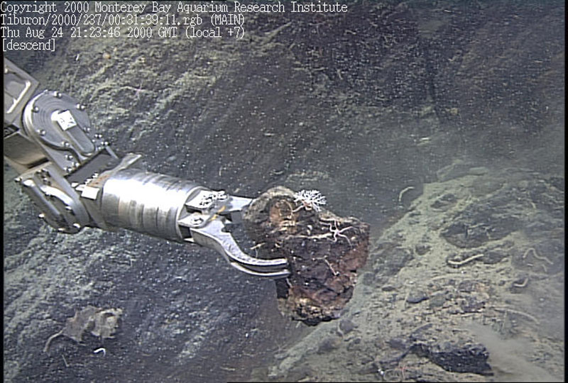
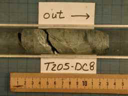
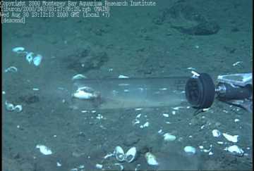
Mendocino ridge. A grab sample from a site halfway up the wall of the Gorda Escarpment, this area was covered with silicified basalt. |
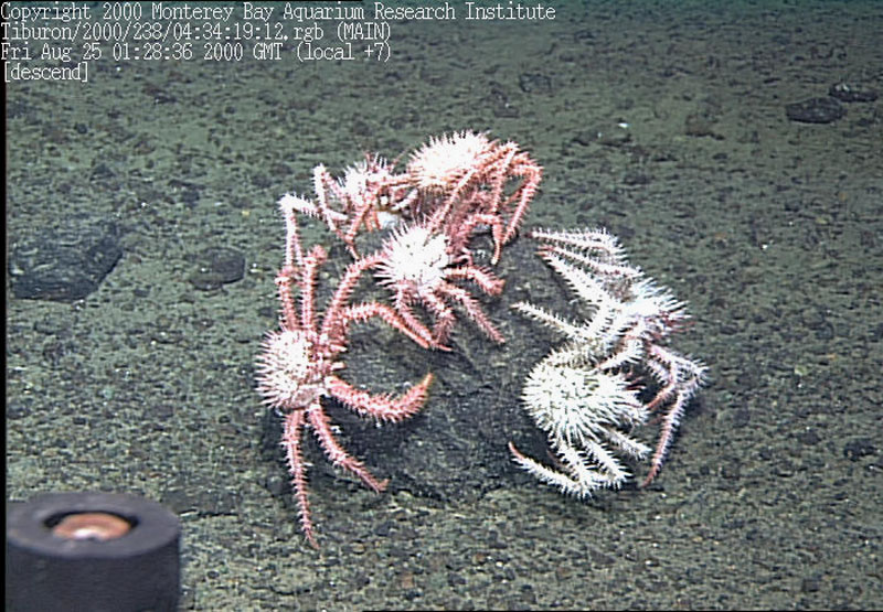
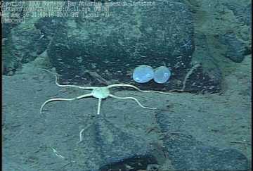
Mendocino ridge.Four crabs playing king of the rock at the top of the ridge |
Mendocino ridge."The Big Kahuna," a layer of siliceous mudstone sticking out of the sediment that may correlate to previous core samples |
Mendocino ridge.Some sediment filled balls dubbed "bioballs", these were filmed at 2800 meters |
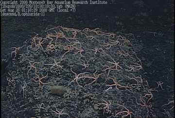
Mendocino ridge.A wonderful aggregation of brittle stars along the flank of the Mendocino Ridge |
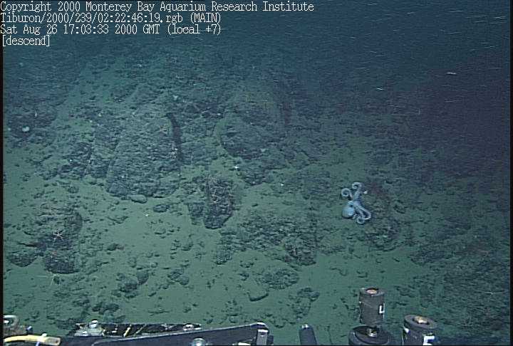
Mendocino ridge.Some unusual benthic organisms including an octopus in the background and a stalked tunicate in the foreground |
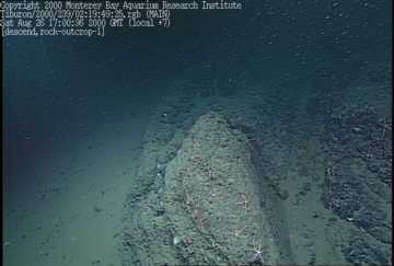
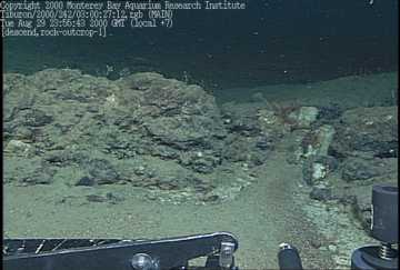
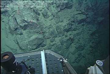
Mendocino ridge.One of the few rocky outcrops observed along the westernmost ridge of the Gorda Escarpment |
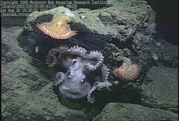
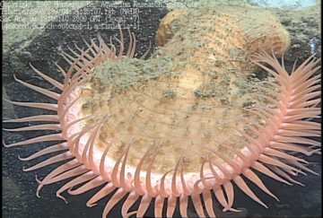
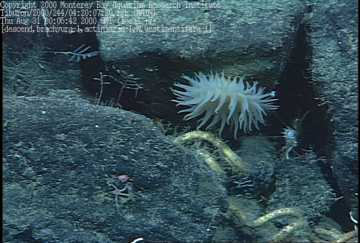
Mendocino ridge.Octopuses garden - another one of the many octopuses that we have observed on this cruise - with two Venus flytrap anemones |
Mendocino ridge.The Venus flytrap anemone - named for its similar morphology and lifestyle |
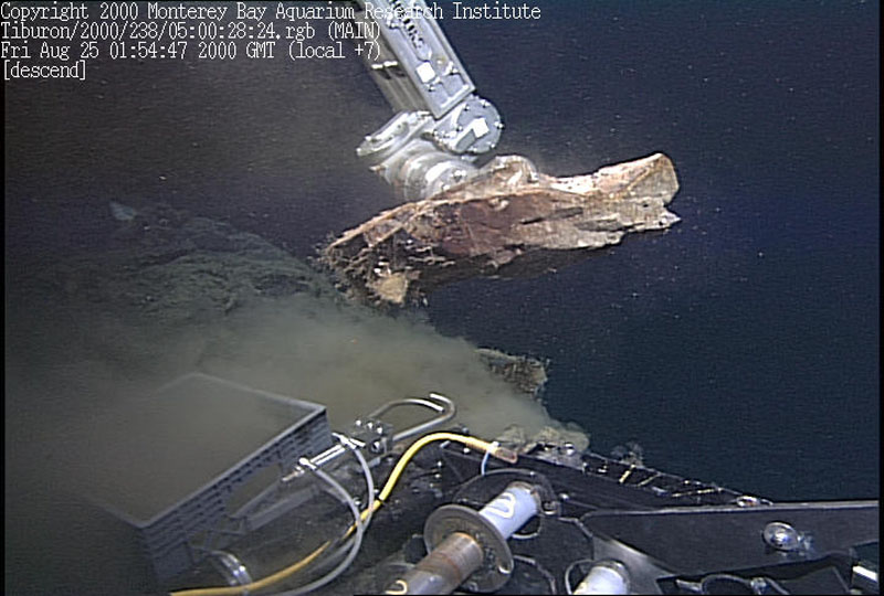
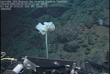
Mendocino ridge.The first rock coring site for the day |
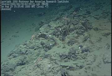
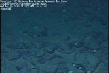
Mendocino Fracture Zone. Hackly piles of talus partially covered with sediment along a steep gully in the Gorda Escarpment. |
Mendocino Fracture Zone. A light-colored siltstone with patches of sand along the Gorda Escarpment |
Mendocino Fracture Zone. A 10 centimeter core of fractured and veined basalt at the top of the ridge in the Gorda Escarpment |
Mendocino Fracture Zone. A 1.3 meter fish that looks like the ribbonfish Trachipterus. Final identification will have to wait until scientists can view the video being brought back to shore later on this month |
Mendocino Fracture Zone. Gorda Escarpment. On the last dive here, we found that the columnar jointed outcrops, found higher up on the wall, yielded the same crystalline basalt found earlier. |
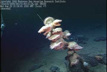
Mendocino Fracture Zone. Tube worms living between the boulders on the bottom in this cold seep area |
Mendocino Fracture Zone. Brittle stars on the slope were common here as well |
Mendocino Fracture Zone. More of the Venus fly-trap anemones that were found all over the bottom (and even up this thin stalk). |
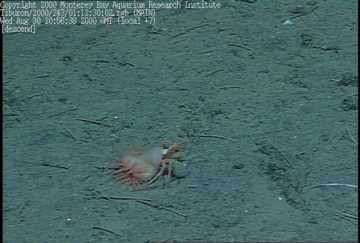
Mendocino Fracture Zone.Hermit crab with an anemone hitching a ride. This is a commensal partnership with both partners benefiting |
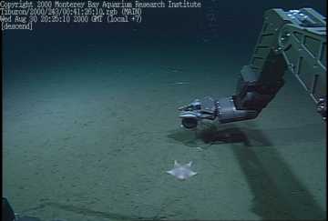
Mendocino Fracture Zone.Seastars were fairly common on the bottom during this dive |
Mendocino Fracture Zone -cold seep clams using a push core. |
Specimens of the new and unusual tunicate that was first observed on the local seamounts are very common on the rocks |
Mendocino Fracture Zone
from MMBARI -http://www.mbari.org/data/mapping/seamounts/mendocino.htm
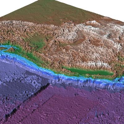
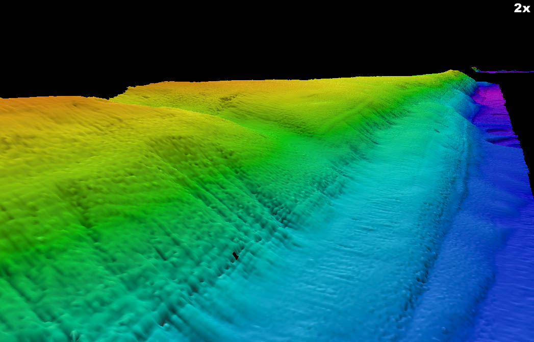
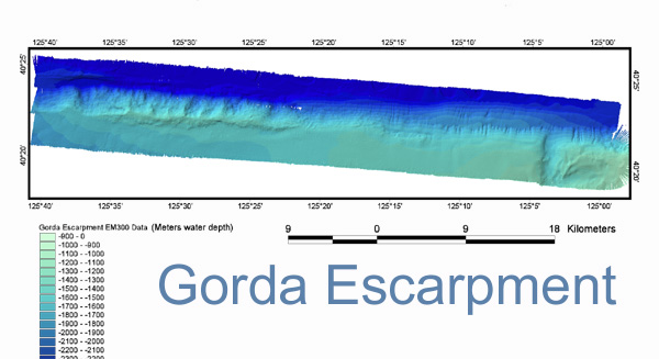
The eastern part of the Mendocino Ridge, where it impinges on the continental margin, is called the Gorda Escarpment. Our survey imaged the escarpment from 125� W to 125� 40� W and shows two distinct morphologies. The eastern part (to about
125� 20� W) is smooth and has low backscatter, suggesting a lack of rock outcrops. Along the eastern part, small canyons commonly cut the lower slopes but do not reach the break-in-slope of the escarpment. The western part is bathymetrically rough and has high backscatter, indicating rock outcrops. The survey continues west as Transits 2B and 2A, which image only part of the Mendocino Ridge.
From http://woodshole.er.usgs.gov/operations/obs/rmobs_pub/html/mendocino.html
Mendocino Triple Junction Offshore Northern California
Written by David Oppenheimer
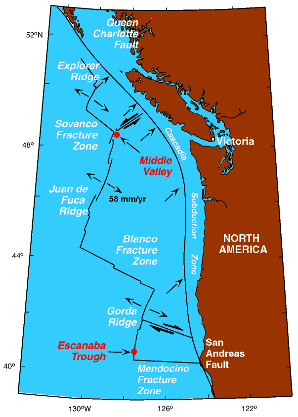
The Mendocino Triple Junction (MTJ) is one of the most seismically active regions of the San Andreas transform system. Since 1983 the region has generated about 80 M3.0 quakes each year, and historically the region has experienced major quakes. This activity is generated in response to ongoing plate motions between the Gorda, North America, and Pacific plates.
�The Gorda plate is converging on the North America plate at about 2.5 to 3 cm/year in the direction N50�E to N55�E. Gorda � North America plate subduction process has resulted in major plate subduction quakes (M8+ in 1700, Ms7.1 in 1992) and is responsible for the uplift of the coastal ranges in the region through motion on thrust and reverse faults.
�Interaction between the Gorda and Pacific plates occurs as oblique convergence at a rate of approximately 5 cm/year in the direction N115�E. Translational motion occurs along the east-west-trending, vertical right-lateral Mendocino transform fault. The most recent, significant quake to rupture this fault occurred 9/1/1994 and had an Mw 7.1. The Gorda-Pacific convergence results in internal deformation of the Gorda plate, such as the 11/8/1980 Ms7.2 quake, and more recently the two Ms6.6 aftershocks of the 1992 quake.
�The San Andreas fault marks the principal Pacific-North America plate boundary south of the MTJ. The SAF last ruptured in the 1906 M7.7 quake and geophysical evidence indicates that rupture extended within a few 10s of km south of the MTJ.
The USGS Northern California Seismic Network (NCSN) and the Berkeley Seismological Laboratory of the University of California Berkeley jointly monitor earthquake activity in the MTJ region. The two institutions operate real-time seismic networks that receive automatically post earthquake information on the Internet within minutes of occurrence. They compute a complete range of seismological products, from earthquake locations, Md, Ml, and Mw, ShakeMaps, first-motion mechanisms, moment tensors, and finite fault estimates through inversion of waveform data. In this region the network consists of analog stations and digital stations with tri-axial broadband and accelerometers that transmit data continuously to either Menlo Park or Berkeley.
There are no islands offshore of the California coast at the MTJ. Thus, earthquake location accuracy rapidly degrades as the quakes occur farther from shore because of the one-sided seismic network station geometry. Depths of quakes west of 124�40''W (approximately 50km offshore) are unreliable except for the larger (M>3.5) quakes for which moment tensor inversions can resolve the depth. Likewise, the location accuracy in the direction perpendicular to the coast degrades with distance offshore. The addition of Ocean Bottom Seismometers (OBS) would greatly improve the ability of the NCSN and BSL to understand the seismotectonics of the MTJ following significant quakes. Improved understanding of the rupture mechanics of a subduction zone quake would enable seismologists and hydrodynamicists to more realistically forecast onshore shaking levels and tsunamis. OBS recordings with extended dynamic range and frequency response could possibly reveal the generation mechanics of slow, tsunami quakes. Near-field recordings of offshore earthquakes would greatly improve depth estimates of aftershock sequences and confirm stress transfer models in a region with significant seismic risk.
There are several earthquake scenarios that could warrant a mobilization of the OBS systems. a) M>6.5 quake on the Gorda-North America subduction zone ("G-NA" polygon), b) M>6.5 quake on the Mendocino fault east of longitude 126�W ("G-P" polygon), and c) M>6 quake on the SAF north of Point Arena ("P-NA" polygon). Deployments within 3 days of such an event are highly desirable due to the unpredictable aftershock decay rate.
There are several harbors along the coast that would provide a base where vessels could be hired to deploy the instruments. Humboldt Bay (Arcata and Eureka) provides the best facilities in the vicinity of the MTJ. There are harbor facilities north of Humboldt Bay at Trinidad and Crescent City. The principal harbors south of the MTJ, which would be more suitable for responding to quakes on the offshore section of the SAF, are at Shelter Cove and Fort Bragg.
Any data recorded by the OBS system will be integrated with the seismic data collected by the NCSN and BSL real-time systems. Phase information (arrival times, amplitudes, durations, etc.) will be merged into the catalog to improve the data set. All parametric data, waveforms, and metadata describing the waveforms will be archived at the Northern California Earthquake Data Center which provides access to the public.
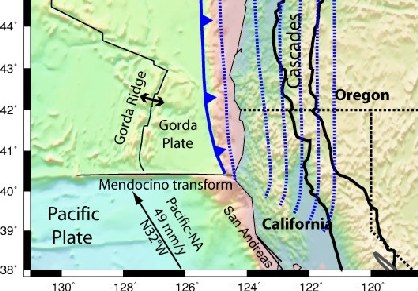
On the eastern side of the boundary there is the North American continental plate and on the western side (starting from the south and heading north) there is the Pacific plate whose boundary with the North American plate runs from the US Mexican border up through California, before curving out to sea north of San Francisco at a place known as Cape Mendocino which is approximately 145 miles south of the state border between California and Oregon. The portion of the plate boundary described above is a 1,300 km (810 mi) long transform boundary known more famously as the San Andreas Fault which has been responsible for a number of (in)famous earthquakes including the 1906 San Francisico earthquake, the 1989 Loma Prieta earthquake and the 2004 Parkfield earthquake.
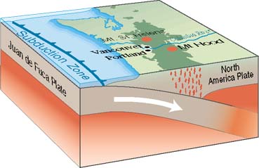
At the point north of Cape Mendocino the boundary changes from a transform to a convergent boundary between the southern portion of the oceanic Juan de Fuca plate (sometimes given a separate name - the Gorda plate) which is being subducted under the North American plate.
This transition point is known as the Mendocino triple junction (where the San Andreas Fault meets the Mendocino Fault and the Cascadia subduction zone, which mark the boundaries of three tectonic plates: the North American, the Pacific Plate, and the Gorda Plate).
The US Geological Survey state that this area is one of the most seismically active along the San Andreas Fault and is responsible for more than 80 Earthquakes a year with magnitudes greater than 3.
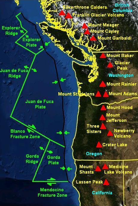
North of this boundary zone lies the Juan de Fuca Plate which is often split into three smaller pieces by geologists (The Gorda section to the south, with the central portion retaining the name Juan de Fuca and the Explorer section to the north). In this region these are being subducted beneath the North American Plate. This is responsible for the formation of the Cascade mountain ranges and the Cascade volcanoes (e.g. Mount St. Helens) and also for some significant historical earthquakes such as the 1700 Cascadia earthquake, which was a special earthquake that occurs in subduction zones known as a megathrust earthquake which are some of the most powerful in the world. In this case it was calculated to have had a magnitude of between 8.9 and 9.2.
The northern boundary of the Juan de Fuca plate lies in Canada where the boundary again returns to being between the Pacific and North American Plates.
This subducting boundary curves along the coast of Canada and Alaska (where it caused the 1964 magnitude 9.2 earthquake and also is responsible for the formation of the Aleutian Island chain.
from http://seismo.berkeley.edu/blogs/seismoblog.php/2008/10/27/where-the-san-andreas-fault-ends
Imagine a busy intersection with a three-way stop sign at rush hour. It takes only a few irresponsible drivers who don''t want to wait their turn and traffic jams and accidents are likely to occur. Something very similar is happening every day in the Earth''s crust under Cape Mendocino. There upheaval is caused not by impatient drivers but by tectonic plates, which are crashing into each other with unstoppable momentum. This tectonic three-way intersection is called the Mendocino Triple Junction. It is one of the few places in the world where three of the gigantic plates which continuously drift on the Earth''s mantle meet.
Along the length of most of California, the San Andreas Fault defines the boundary between the Pacific Plate to the west and the North American Plate to the east. Along the fault line, the Pacific Plate slides horizontally in a northnorthwesterly direction with respect to North America.
Under Cape Mendocino, this trip comes to an abrupt halt, because another plate gets in the way. North of the Cape the off-shore Gorda Plate, a small cousin of the Pacific Plate, glides under the North American Plate in what is called a subduction zone. The boundary line between the Pacific Plate and the Gorda Plate is a fault similiar to the San Andreas, called variably the Mendocino Transform or the Mendocino Fracture Zone. It goes from Cape Mendocino for several hundred miles due west into the Pacific Ocean. Along this fault, the Gorda Plate slides horizontally to the east with respect to the Pacific Plate with a speed of about 2 inches per year.
Because of the different directions and the various rates of movement of the three plates, the area under Cape Mendocino and a region immediately off-shore has to absorb a lot of mechanical strain. That makes this area one of the most seismically active regions in the state. During the last three decades alone, two strong earthquakes with magnitudes above 7 have occured there, one in 1980 and the other one in 1994. Every year at least 80 temblors with magnitudes over three are recorded in this region, like the earthquake duo which shook the area early on Sunday morning.
Another tectonically important triple junction is the Afar Triangle, where the Golf of Aden and the Red Sea meet the northern end of the East African Rift Valley. The Galapagos Islands are also located on a triple junction. Under the islands made famous by Darwin''s research, three oceanic plates meet: Pacific, Nazca and Cocos. There is however a major difference between the Galapagos Triple Junction and the three-way intersection under Cape Mendocino. While under Northern California the plates crash into one another, the three plates under Galapaos are moving away from each other.
Photos from http://www.mbari.org/expeditions/Mendocino/August24.htm
http://www.mbari.org/expeditions/Mendocino2001/index.htm
See text also
Mendocino Fracture Zone
MENDOCINO TRIPLE JUNCTION
Mendocino Fracture Zone