 | Mineralisation in SW Pacific region |
|
|
|
|
|
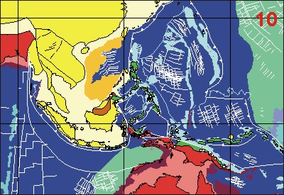
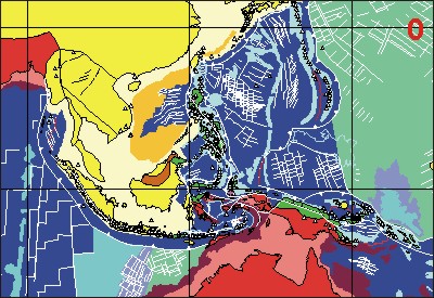
http://eswww.rhul.ac.uk/geode/SWPacific.html Global continental and ocean basin reconstructions since 200 Ma
Ľ Manuel Pubellier emphasised the high rates of deformation processes, which require the study of a modern, active setting in order to appreciate and measure them. He pointed out that during an arcľcontinent collision there is a large amount of syn-tectonic magmatic activity and a rapid change in tectonic setting. A shift from subduction plateau to short-lived collision and new subduction can occur within 1 million years.
Ľ In New Guinea, gold deposits are associated with thrusts and lateral ramps ľ Syntectonic porphyry Cu was injected between 7 and 2 Ma into thrust planes and then cut by later thrust planes. The tectonic setting changed again after 2 Ma becoming wrenching at the front of the belt, the lateral ramps subsequently becoming reactivated as normal faults. Mineralisation may come with one phase and be destroyed by the next one. These rapidly evolving systems show how essential it is to have accurate dating of events and underline the over-simplification that we make when we try to understand ancient orogens.
Ľ Seismic tomography and the mantle beneath SE Asia ľ Wim Spakman & Harmen Bijwaard (Utrecht, wims@terra.geo.uu.nl ):
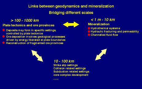
Links between geodynamics and mineralisation ľ Andor Lips (Utrecht, alips@terra.geo.uu.nl):
Andor Lips began by pointing out the need to consider scale when considering mineralisation within the geodynamic context. Whereas plate tectonics operate on a scale of 100ľ1000 km, the mineralisation processes involving hydrothermal systems, hydraulic fracturing and, channelled fluid flow operate in the scale range of 1 mľ10 km. Linking them, at intermediate scales of 10ľ100 km, are the various structural settings of fault systems, crustal uplift and subsidence, sedimentary basin development, magmatic emplacement etc. (Figure 4 below
Mineral deposits form in a variety of such structural settings, that are in turn dependent on plate tectonics, and ore deposition is driven by energy liberated at plate boundaries (Figure 5 below).
Furthermore, we have to appreciate that some mineral deposits are syngenetic with the host rocks, whilst others are epigenetic. Considering the SW Pacific region, a map of mineral deposits clearly indicates the geographic linkage between volcanic arcs and mineralisation (Rogerson & McKee, 1990; Mitchell, 1992; van Leeuwen, 1994; Djumhani, 1996). But a number of questions arise ľ what is the volume of magmatism around the arcs? Is it uniform? Has volcanic activity been continuous or pulsed? What are the ages of the mineral deposits ľ have there been discrete periods of mineralisation in specific areas? The map of ore deposit types shows some geographical patterns, e.g. Sn, W deposits are mainly in the peninsular area of Malaysia southward to the southeast of Sumatra. However, VMS and porphyry deposits are distributed all around the arcs. Around the arcs the deposits are epithermal, originating at high crustal levels, requiring relatively little uplift and erosion to bring them to surface at the present day. An intriguing question is how long they would last, given the generally high rates of uplift of the arcs, and how it has been possible for similar deposits to have been preserved on the longer geological timescale.
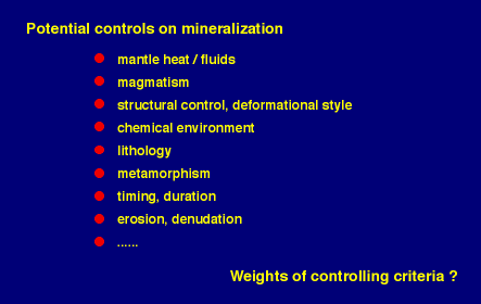
As an example, the ore deposits of the Bayah Dome in Java are 2 Ma although their host rocks are mid-Miocene in age (Marcoux & Milesi, 1994; Milesi et al, 1994). Within a 20 km distance, the mineralisation ranges from Au-Ag-Sn-W to Au-Ag. The mineral deposits are localised by structural controls, in particular a strike-slip fault that was reactivated as a normal fault (Cirotan vein; Milesi et al, 1994). The mineralisation sequence of the Cirotan vein is silicification, siliceous breccia, Cockade breccia, Bonanza. Although the 1.7 Ma K-Ar age on adularia (Marcoux & Milesi, 1994) may relate to the silicification, the time-scale for the complete mineralisation process is unknown. The difficulty in obtaining high quality dating of the actual mineralisation phases (requiring suites of high accuracy, high precision dates) remains the single most important obstacle to advancing our understanding of mineralisation processes. In summary, although it is generally possible to identify the potential controls on mineralisation, the difficulty is in determining which are the vital ones.
Djumhani, 1996. Indonesian Mining Journal, 2: 18ľ21
Leeuwen, T. van, 1994. J. Geochem. Expl., 50: 13ľ90
Marcoux, E. & J.P. MilÚsi, 1994. J. Geochem. Expl. 50: 393ľ408
MilÚsi J.P., E. Marcoux, P. Nehlig, Y. Sunarya, A. Sukandar & J. Felenc, 1994. Economic Geology, 89: 227ľ45
Mitchell, A.H.G., 1992. Trans. Inst Min. Metall., 101: 125ľ38
Rogerson, R. & C. McKee, 1990. Geology of the mineral deposits of Australia and Papua New Guinea (Ed. F.E. Hughes): 1689ľ701
The tectonic setting of Grasberg ľ Hugo de Boorder (Utrecht, hdboordr@geo.uu.nl):
Grasberg is the biggest known concentration of copper and gold in the world and was formed in the Pliocene. Something rather special must have caused it. Hugo de Boorder first looked at the seismic tomography imagery (courtesy Wim Spakman) to see if there could be any deep indications. Although there are several anomalous regions at various levels in the mantle in the general vicinity, one unusual feature may be of significance. This is a narrow, linear anomaly at around 95 km depth, trending NNE, which extends from the Grasberg district across the region of the Arafura Sea to northwestern Australia for ca. 1500 km. It shows as a relatively weak low-velocity (warm) anomaly against a uniformly high velocity (cool) background. This anomaly runs into the NNE striking Halls Creek Mobile Zone along the eastern edge of the Kimberley Block of northwestern Australia. This zone and the WNW-striking King Leopold Mobile Zone, along the southern edge of the Kimberley Block, operated as a coupled orthogonal system during alternating periods of extension and compression between the Early Proterozoic and the Holocene (White & Muir, 1989). These mobile zones host kimberlites and lamproites. It is of interest that isotope characteristics (Nd, Sr and Pb) of magmatic rocks from locations in western New Guinea, including the Pliocene Grasberg district, appear quite distinct from those of Neogene magmatic rocks elsewhere in New Guinea (Housh & McMahon, 2000). However, similarities are found with kimberlites and lamproites in northwestern Australia. The Argyle diamond mine is situated in a Proterozoic lamproite in the Halls Creek Mobile Zone. The linear low-velocity anomaly is tentatively interpreted to represent one of a number of NNE-striking transfer zones which acted as deep lateral ramps during the development of the New Guinea thrust and fold belt and the northward subduction of the Australian continental crust. Several of these were documented in Papua New Guinea and argued to have controlled fluid flow and prolific Cu-Au mineralisation by Corbett (1994). The singularity of the above low-velocity anomaly and the magnitude and longevity of the Halls Creek Mobile Zone are speculated to have a bearing on the volumetrically outstanding nature of the Grasberg district. Pending detailed analysis of this anomaly, it is suggested that travel-time tomography can contribute to the delineation of major structures in cratons affected by neotectonic deformation processes.
At the surface, Grasberg is located at the intersection of a NE-trending fault, the Gauttier Offset (Dow et al., 1988), and an EľW-trending fault set, the structural pattern shown by Manuel Pubellier to have been involved in Oligocene reactivation. It is suggested that the Gauttier Offset relates to the dominant transcurrent deformation involved in the oblique subduction below the Caroline Plate, combining with the inferred deeper structure into a complex relay and roll back of the subducted slab below central Western New Guinea. This concurs with small, northeast elongated, high velocity anomalies at 260 and 350 km depth below the Fly Platform, to the southeast of Grasberg.
Corbett, G.J. 1994. Regional structural control of selected Cu/Au occurrences in Papua New Guinea. Proceedings of the PNG Geology, Exploration and Mining Conference 1994. The Australasian Institute of Mining and Metallurgy, 57ľ70.
Dow, D. B., Robinson, G. P., Hartono, U. & Ratman, N. 1988. Geology of Irian Jaya. Preliminary Geological Report. Indonesia-Australia Geological Mapping Project. Geological Research and Development Centre, Indonesia in cooperation with BMR, 298 p.
Housh, T. and McMahon, T.P. 2000. Neogene potassic magmatism in western New Guinea. Lithos 50: 217ľ39.
White, S.H. & Muir, S.D. 1989. Multiple reactivation of coupled orthogonal fault systems: an example from the Kimberley region in north Western Australia. Geology 17: 618ľ21.
Magma sources in western Pacific magmatism ľ Colin Macpherson (Royal Holloway/University of Durham, colin.macpherson@durham.ac.uk):
Colin Macpherson first pointed out the controls on partial melting in the Earth''s interior. This occurs whenever and wherever the actual temperature exceeds the melting temperature. It can happen through an increase in temperature, a decrease in pressure or a change in composition (e.g. through hydration). Thus temporal changes in the dynamics of a subduction system are fundamental. At a subduction zone, for example, hinge retreat and slab rollback produce mantle upwelling above the retreating slab, thus inducing partial melting. Other dynamic changes in plate movements that can induce partial melting include time-variable parameters such as the subduction rate, stress orientation in the upper plate, recycled flux and composition and the rate of wedge replenishment. Crustal composition in the overriding plate influences the chemical environment of the upward moving metal fluid flux. Considering island arc magmatism, there is a range of compositions, with andesites and dacites fairly common. Magmas are generally depleted in HFSE and enriched in large ion lithophile elements. It is possible to use trace element and isotopic ratios to identify dynamic changes in subduction zone through time. A major challenge is to relate these dynamic changes to the times and environments in which ore genesis occurs.
The presence in the Bismark Sea of the "Manus Plume", recognised by Wim Spakman on seismic tomographic imagery, is of particular interest. There is isotopic confirmation of this from the 3He/4He signature, which is typical of a mantle plume (Macpherson et al., 1998). The recent dramatic recovery of a gold-laced "black smoker" from the seafloor off Papua New Guinea (probably the PACMANUS area of the SE Manus Basin), 2.7 metres long, 80 cm in diameter at the base, teeming with bacteria and archaea, provides clear evidence of current mineralisation in the area. To find out the role of the plume in the magmatic and mineralisation processes it is instructive to reconstruct the hotspot track for the past 50 million years, using Robert Hall''s plate reconstructions. These show that during the Oligo-Miocene the track seems to coincide with the Eauripik Rise; an otherwise unexplained topographic high in the sea floor across the Caroline Plate. Taking the track further back in time to the Eocene, it is seen that the plume location coincides with excess magmatism in the IzuľBonin Mariana fore arc and back-arc volcanic rocks similar in composition to ocean-island basalt rather than subduction zone lavas. Furthermore, VMS style mineralisation has been found in the Manus Basin (Binns & Scott, 1993). It is intriguing to speculate whether we can find similar deposits further back along the hotspot trail.
Finally, Colin commented on the origins of adakite. He pointed out that adakite is defined as a dacite with a specific chemical composition. It is generally regarded as having formed through partial melting of a lithospheric slab that has undergone an eclogite transformation during subduction, and its presence is often interpreted as indicative of slab melting (Defant & Drummond, 1990). However, there are examples, e.g. in the eastern Philippines, where adakite is present with no slab melting. It is possible to conceive a model for the formation of adakite without slab melting. Arc magmas that crystallise at depth (> 30 km) in subduction zones will crystallise to a garnet-bearing assemblage (De Bari & Coleman, 1989). This may be particularly common during the late stage of any phase of arc magmatism. These assemblages could stay in place within the mantle until a new phase of arc magmatism produces partial melting of the hydrous, garnet-bearing basaltic ecolgite that would produce magma with the composition of adakite. So not all adakites may have formed from slab melting.
Binns, R.A. & Scott, S.D. 1993. Actively forming polymetallic sulphide deposits associated with felsic volcanic rocks in the eastern Manus back-arc basin, Papua New Guinea. Economic Geology 88: 2226ľ36.
DeBari, S.M. and Coleman, R.G. 1989. Examination of the deep levels of an island arc: evidence from the Tonsina ultramafic assemblage, Tonsina, Alaska. Journal of Geophysical Research 94: 4373ľ91.
Defant, M.J. & Drummond, M.S. 1990. Derivation of some modern arc magmas by melting of young subducted lithosphere. Nature 347: 662ľ5.
Macpherson, C.G., Hilton, D.R. , Sinton, J.M., Poreda, R.J. & Craig. H. 1998. High 3He/4He ratios in the Manus Back-Arc Basin: implications for mantle mixing and the origin of plumes in the western Pacific Ocean. Geology 26: 1007ľ10.
High sulphidation VHMS mineralisation (Ba-Au-Ag-Cu) on Wetar Island, Indonesia ľ Philip Scotney (Southampton, psco@soc.soton.ac.uk):
Philip Scotney described the geology and mineralisation of unusual VMS deposits on Wetar Island, Indonesia. Wetar Island comprises Oligocene to Recent volcanics with minor oceanic sediments and lies in the Banda volcanic arc, a chain of islands surrounding the Banda basin at the eastern end of the Indonesian archipelago. Mineralisation is hosted by volcanic flows and intrusives with post mineralisation lahars, sub-aqueous debris flows and pyroclastic rocks covering much of the deposits. Overlying the Barite sands and massive sulphides at Kali Kuning is a deep water limestone. Two economic orebodies were defined at Kali Kuning and Lerokis, comprising asymmetric massive sulphide mounds flanked by generally poorly consolidated baritic sands. The mounds are underlain by stockworks and breccia zones. Mining has removed only the associated Au-Ag-bearing barite sands (2.9Mt at 3.5g/t Au, 114 g/t Ag & 40% barite at Lerokis; 2.2Mt at 5.5g/t Au, 146g/t Ag & 60% barite at Kali Kuning), with the sulphide mounds at each deposit (ca. 5 Mt each) remaining unexploited. Linear and pipe-like iron oxide structures are evident at Lerokis Zones 4 and 5, which appear to be fluid feeders to parts of the barite sand bodies. The massive sulphides form mound-like bodies of arsenian pyrite (up to 6.7 wt% As), cut by later fractures infilled with high-sulphidation sulphides including covellite, chalcocite tennantite-tetrahedrite and iron-poor sphalerite. Mapping and integrated XRD and infrared investigation reveals an alteration assemblage dominated by an outer zone of illite-kaolinite-smectite with a very local core of vuggy silica alteration marginal to mineralisation. Minor alunite and traces of pyrophyllite have been identified in this zone. Sulphur isotope study shows values for the sulphides and sulphates similar to typical Kuroko values with variable entrainment of seawater within the altered footwall zone.
Aspects of mineralisation on Wetar are consistent with both a sea-floor exhalative/shallow replacement origin and a relationship to acidic, oxidised hydrothermal fluids typical for those responsible for high-sulphidation epithermal mineralisation. Wetar may therefore be an example of a VHMS system with a significant component of hydrothermal fluid derived from a magmatic system. Ongoing fluid inclusion study, coupled with strontium and helium isotope analysis, seeks to define the possible role of magma-sourced fluids in the hydrothermal system. The mineralisation has taken place in a rapidly evolving tectonic environment. Currently, Wetar is experiencing rapid uplift above the Wetar Thrust, having been involved in the collision between the Banda Arc and the NW Australian continental shelf. However, as Robert Hall pointed out in discussion, all this had happened subsequently, and at 4.7 Ma, Wetar was in a deep water oceanic environment, confirmed by the presence of the overlying deep water limestone. None the less, subsequent uplift had had the effect of bringing the mineral deposits to the surface and the question remains about the extent and duration of alteration and concentration of the metal ores in the Ba sands, following the VMS mineralisation at 4.7 Ma.
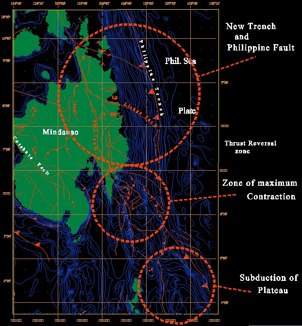
Mineralisation in the Philippines ľ Michel Faure (OrlÚans, Michel.Faure@univ-orleans.fr):
Michel Faure explained that gold and porphyry copper deposits on E Mindanao are related to adakite. They were all deposited within the past 10 million years (and probably younger than 5Ma). The location of the ore bodies near the Philippines Fault suggests some relationship between fluid circulation and ore concentration with faulting.
For example, preliminary structural studies in SE Mindanao (Diwalwal gold field), see Figure 6, show that the orebody dips to the SľSSW and trends more or less parallel to a set of normal faults. The fault is one of a number of tension gashes within the strike-slip zone of the Philippines Fault. To the north, in central E Mindanao, the Coo mine orebody is vertical and is frequently cut by late faults. Mineralised quartz trends parallel to a sinistral strike-slip fault that could be a branch of the Philippines Fault. Finally, at the northern end of E Mindanao (Surigao area), a study of the structural setting of Manila Mining is presently in progress. The preliminary results suggest that the orebody lies within a volcanic caldera. It is clear that for most of the orebodies on E Mindanao, the voids which were filled in by mineralised quartz correspond to metre to kilometre-scale tension gashes or pull-aparts. Their geometry complies with a left-lateral NľS-trending wrench fault. The Philippine Fault is the most suitable structure to account for the creation of space in transtensional zones along its length. However, it is worth noting that the geometric and kinematic analyses of the presently mined ore bodies do not provide any additional knowledge on the origin and transport of metals. These questions will be addressed by mineralogical and geochemical approaches.
Gold, Hot Springs and Adakites ľ Mireille PolvÚ (Toulouse, polve@lucid.ups-tlse.fr):
Mireille PolvÚ explained that adakites are special subduction-related magmatic rocks, rich in Si and water, enriched in Sr, but depleted in Y and REE. They have a MORB-type isotopic signature for Nd and Pb. They have been found in volcanics all round the Pacific rim and are regarded generally as the result of partial melting of oceanic crust. Their geodynamic framework can be from young, hot oceanic crust, or they can come at the beginning of subduction, the end of subduction, or from fast, oblique subduction. There is an association between adakite and gold mineralisation all over the world. In E Mindanao, Plio-Pleistocene adakites are linked with intrusions containing epithermal Au and Cu. One always finds the association: intrusion-volcanic clasts-mineralisation. There is evidence of syngenetic and high hydrothermal alteration. Compared with classical epithermal gold deposits, there is a specific mineral association, including the presence of pyrite but no adularia. Various questions arise about the association between adakite and gold mineralisation. Does adakite provide the gold? Does it provide special fluids (specific ions)? Do adakite intrusions trigger hydrothermal convection? Do adakite intrusions "re-cycle" Au from older volcanic terrains? Geochemical investigations may supply some of the answers, a) through the analysis of the Au content in adakite and calc-alkaline volcanics, b) looking at major and trace elements in fluid inclusions and in present day hydrothermal fluids taken as analogues of the genetic fluids, c) looking at the mineralogy of alteration minerals(clays), and considering the thermodynamic constraints. The geodynamic implications also require investigation, involving field and petrological evidence, the association of mineralisation with adakite intrusions, and hydrothermal alteration. In the ensuing discussion, the point was made that much of the above could be related to the characteristic features of porphyry copper deposits not associated with adakite. Since adakite is a form of dacite with specific chemical properties, it is quite possible that many dacites have not been recognised as being adakite ľ more Sr and REE analyses are needed in relation to mineral deposits. Equally, if the association between adakite and mineralisation is to be understood, then the connection must be made between the specific chemical properties of adakite which enhance the mineralisation process, to explain why adakite, rather than dacite, is the critical factor.
Lessons for European mineralisation
Mineralisation in the Eastern Alps during the Alpine orogenic cycle ľ Walter Prochaska (Leoben, prochask@unileoben.ac.at):
Walter Prochaska focused our attention on the tectonic and metamorphic events of the Eastern Alps. The tectonic map of the region shows several tectonic windows of the lower Penninic unit of the European plate within the tectonically higher Austroalpine System. The Alpine tectono-metamorphic event began in the Permian when rifting started in the Austroalpine Units and the deposition of Haselgebirge. This was followed by the formation of oceanic crust during the Middle Triassic. Subduction began in the Late Jurassic, resulting in continental collision and a metamorphic peak in the Upper Cretaceous. This was followed by uplift and subsequently the intrusion of magmatic bodies during the Eocene. Lateral escape structures became active during the Late Tertiary, including in a number of EŚW trending strike-slip faults. Within this context, the generation of fluids and mineralisation occurred at various stages:
Ľ Permo-Trias: siderite stocks formed from rift-related evaporitic brines
Ľ 90 Ma: Leucophyllites formed from sea water in ductile shear zones
Ľ 90ľ70 Ma: As-Au-Cu veins formed from evolved meteoric water during post-metamorphic uplift
Ľ Late Tertiary: hematite and siderite veins formed from metamorphic fluids expelled from deep faults in a transpressive regime.
Walter pointed out the dangers of following fashion in genetic modelling (e.g. between syngenetic and epigenetic origins), demonstrating this with the evidence that the trend of compositions of Permo-Trias siderite at the Erzberg mine confirms that it formed from brines working their way down from surface evaporites, and were not from deep brines circulating at a later date. In contrast, the Late Tertiary siderites formed from a hydrothermal system fed by a mix of sea water and fresh water, so the brine has a composition that is intermediate between the two. Its Ar signature indicates that there is also a fluid component from deep sources. The siderite/hematite mineralisation formed at a temperature of 300ľ320űC, but there is no magmatism that can be directly related to the hydrothermal circulation. However, there could be magmatic bodies hidden deep in the crust as possible sources of heat.
Lessons for GEODE ľ Derek Blundell (Royal Holloway, d.blundell@gl.rhbnc.ac.uk):
When attempting to understand the mineralisation processes that occurred to form a major ore deposit in the geological past, especially the reasons why the deposit formed at a particular time and location within an evolving orogenic system, it is instructive to look at mineralisation in a modern, active subduction system as complex as the Southwest Pacific region. In particular, it is possible to measure and quantify the rates at which both tectonic and mineralising processes occur. From this workshop, the following lessons can be learned which could be applied to each of the five main projects of GEODE that are focused on European mineral provinces:
Ľ In a complex subduction system, although generally collisional, regions of extension develop, e.g. through slab retreat (rollback), due to a change in properties of the subducting plate. Slab retreat is a process that generates heat from the upwelling of hot asthenosphere ahead of the retreating slab, hence partial melting, magmatism and associated mineralisation. Dynamic changes in plate motions, which are dependent upon time-variable parameters, are the events most likely to control the timing and location of mineralisation.
Ľ Tectonic events occur rapidly and tectonic features can be ephemeral and will not be preserved, e.g. Woodlark Basin is being destroyed by subduction as it is being formed by extension.
Ľ Seismic tomography not only images mantle as it is now, but subduction slab anomalies can be interpreted in terms of the past history of subduction. This can be used to test tectonic plate reconstructions, e.g. the Rangin model of SW Pacific plate motions. Seismic tomography can also image slab detachment, mantle plumes (e.g. Manus Plume) and other tectonic features deep in the mantle.
Ľ There is evidence of slab detachment beneath the Apennines and the Carpathian Arc (possibly also the Banda Arc at Timor). Thermo-mechanical modelling of subduction can predict the depth of detachment, where stress │ strength, which depends on a change in the strength of the subducting lithosphere. Slab tear occurs, that can be verified from observation of the migration of the null point between subsidence and uplift around the arc. Thermal modelling identifies the time and location of the heat pulse associated with slab detachment at shallow depth, which is the starting point for partial melting, magma generation and possible mineralisation. The process can be observed by analysis of P-T-t pathways and geochemical signatures.
Ľ Wim Spakman is now able to invert GPS relative motion data to display maps of slippage on pre-defined major faults, rotation rates of particular areas and effective strain rates. This helps to quantify current rates of deformation and presents GPS data in a way that is more directly applicable to structural analysis. Regions of current tectonic activity in Europe such as the western and eastern Mediterranean (Apennines, Hellenides) can be analysed in this way.
Ľ Magmatic and mineralisation processes operate just as fast as tectonic processes. For this reason, the single most important requirement for a better understanding of mineralisation is to have high precision, high accuracy dating of suites of ore minerals. It is acknowledged that this is difficult because of the lack of suitable dating methods that can be applied directly to ore minerals, so that indirect methods have to be applied, but new techniques and instrumentation are available, which need to be better utilised. Since this is a universal requirement in GEODE projects, a special effort is called for in GEODE to give more impetus to dating ore deposits.
Ľ Although it is possible to identify the potential controls on mineralisation, the problem remains to identify the critical factors. Very large deposits are rare occurrences in the geological record and are likely to have resulted from the combination of an unusual set of circumstances. The huge copper deposit of Grasberg is an example of the combination of very long-lived, repeatedly reactivated movements of a major deep fault with modern tectonic plate motions that have produced additional heat and magmatism, and an intersection strike-slip regime.
Ľ Following the hotspot trail of the Manus plume (initially recognised from seismic tomography but confirmed by the geochemical signature) using plate reconstructions, links its location with volcanics of ocean-island composition and VMS deposits. This could provide a valuable modern analogue to aid exploration strategy.
Ľ Unusual gold mineralisation on Wetar (Banda Arc), contained in Ba sands overlying a massive pyrite body, is an example of a VMS deposit that probably formed in a deep oceanic environment , which rapidly changed to arcľcontinent collision, resulting in uplift and erosion that brought a young mineral deposit to surface. With this rate of uplift and erosion continuing, it will soon be lost to the geological record, thus emphasising the ephemeral nature of such deposits.
Ľ Extension associated with the Philippines Fault zone, evident in pullaparts and tension gashes, was the driving force and provided space for magmatic intrusions and gold mineralisation on E Mindanao. Gold mineralisation is linked with adakites ľ dacites of a particular chemical composition, which are rich in Si and water, enriched in Sr, but depleted in Y and REE, and have a MORB-type isotopic signature. There is a widespread association of gold with adakites in island arc environments, so that Sr analysis of dacites associated with gold mineralisation in the southern Urals would be worthwhile to establish whether or not adakite is involved. There may be other examples in GEODE project areas.
Ľ Whilst the SW Pacific region can provide modern analogues of some ore provinces in Europe, where the tectonic environment was one of subduction, island arcs and arcľcontinent collision, it does not offer analogues for other tectonic regimes in which mineralisation occurs. This point was evident in the mineralisation of the Eastern Alps, involved in continental rifting and continental collision, for which other modern analogues might be sought.
Ľ Much of the discussion revolved around the speed of tectonic, magmatic and mineralisation processes and the need to understand bettor the factors which govern the timing and location of ore deposits within an evolving orogenic system. Consequently, a number of speakers would be keen to contribute to a symposium on such a topic, if this can be arranged as part of the scientific programme of the EUG Assembly in 2001. The richness of the discussion, enjoyed by all the participants, will most surely lead to a number of new collaborative research initiatives. And hopefully this report will provide a basis for extending the collaboration across the GEODE community.
http://eswww.rhul.ac.uk/geode/SWPacific.html