 | Monterey Bay |
http://www.mbari.org/data/mapping/monterey/default.htm |
|
Ascension slope -http://www.mbari.org/data/mapping/monterey/images/ascension_slope_1000x788.jpg |
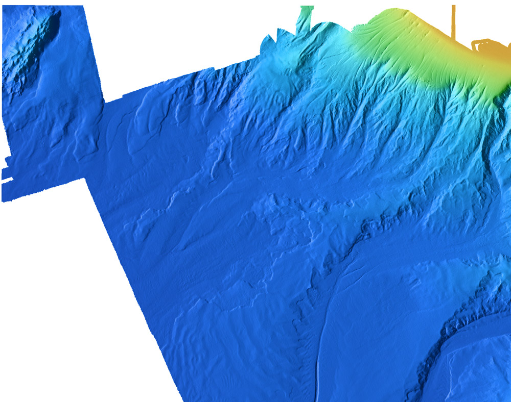
Monterey canyon systemhttp://www.mbari.org/data/mapping/monterey/images/monterey_canyon_1000x957.jpg - |
Sur Ridge -http://www.mbari.org/data/mapping/monterey/sur_ridge.htm |
http://www.mbari.org/data/mapping/monterey/sur_ridge.htm |
Sur Canyon -http://www.mbari.org/data/mapping/monterey/sur_ridge.htm |
http://www.mbari.org/data/mapping/monterey/sur_ridge.htm |
Upper Lucia Canyon - http://www.mbari.org/data/mapping/monterey/upper_lucia.htm |
Lover Lucia Canyon -http://www.mbari.org/data/mapping/monterey/lower_lucia.htm |
Shepard meander-http://www.mbari.org/data/mapping/monterey/images/shepard_meander_1000x929.jpg, http://www.mbari.org/data/mapping/monterey/shepard.htm |
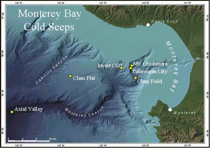
Cold seep locations -http://www.mbari.org/benthic/coldseeploc.htm |
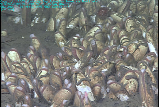
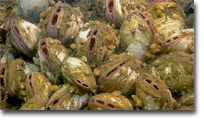
Whale Fall set. Lots of clams and big fat worms. This morning our dive began at a large clam bed near the location of the whale carcass, at a depth of about 2900m. The bottom of the Monterey Canyon is sprinkled with patches of clams that live in the sediments. The clams are filled with symbiotic bacteria that help them get their nutrition from sulfides - naturally occurring toxic chemicals that leak out of the mud and smell like rotten eggs |
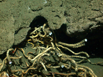
Whale fall set. the mysterious whale-bone worm |
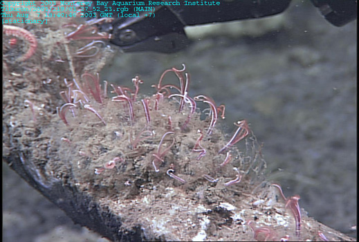
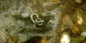
Whale fall set. In addition to fish, sea cucumbers, sea stars and lacy, stalked crinoids, we found many wonderful specimens of a deep-sea tubeworm, Lamellibrachia. This worm lives on the sulfides that leak out of the sediments, just like the clams we saw yesterday. Each worm contains millions of tiny bacteria that turn the toxic sulfide into energy that the worm can then use for nutrition. The worms make their own housesŚhard tubes that twist and turn and can reach lengths of a meter or more |
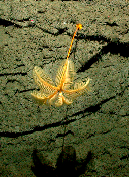
A beautiful crinoid casts a shadow on the rock walls |
Seep animals -Vesicomyid clams -Cold seeps (Slides and ecology -http://www.mbari.org/benthic/coldseeptour.htm) - http://www.mbari.org/benthic/coldseeps.htm |
Seep animals-Bacterial Mats -http://www.mbari.org/benthic/seepanimals.htm |
Seep animals -Vestimentiferan Worm -http://www.mbari.org/benthic/seepanimals.htm |
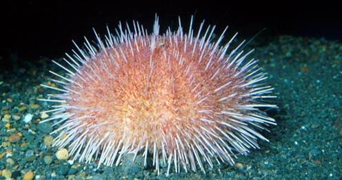
Deep-sea "Fragile Urchin", Allocentrotus fragilis -http://www.mbari.org/benthic/biologyco2.html |
|
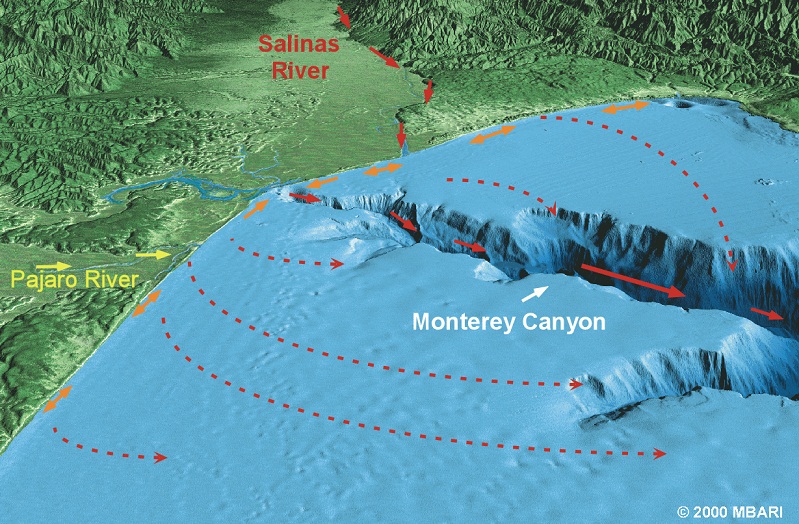
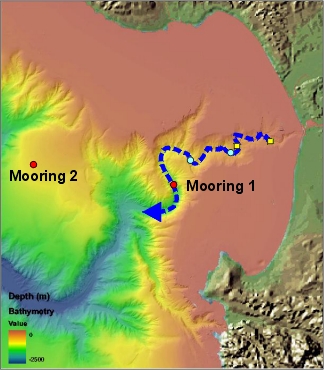
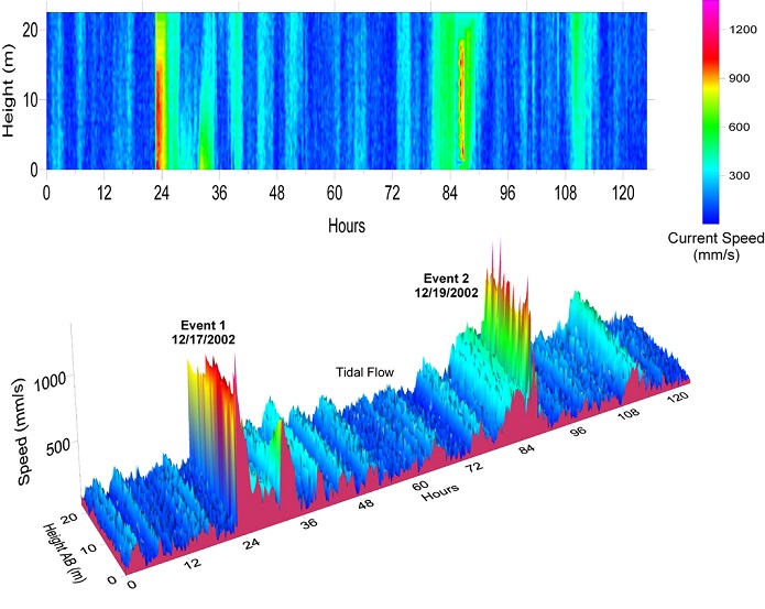
Monterey Canyon Turbidity flow area -http://www.mbari.org/benthic/Turbidity_Event_2002/canyon_events.html |
Monterey Canyon Turbidity flow A time-series profile of current speed above the bottom -http://www.mbari.org/benthic/Turbidity_Event_2002/canyon_events.html |
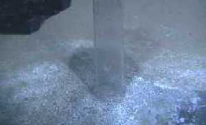
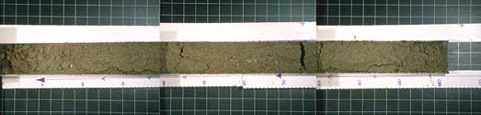
Monterey canyon. This vibracore is approximately 127 inches in length. The sediment is uniformly sand-http://www.mbari.org/canyon/coresystem.htm |
Middle sequence of some vibracores - This vibracore shows a sequence of variability and oscillations between sand and clay. |
The last part of cores -This vibracore contains a slump deposit, which is indicative of high energy deposition events |
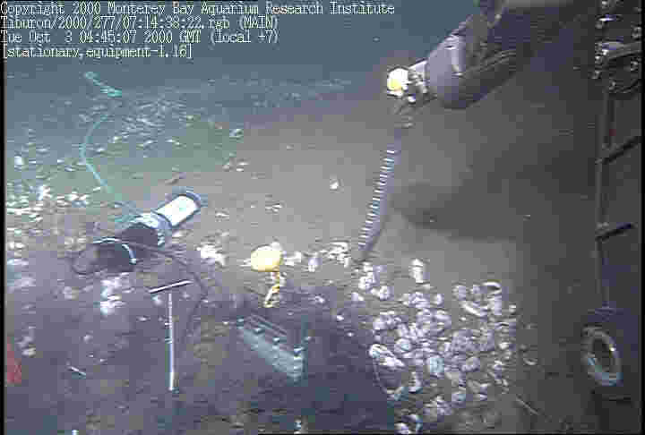
Paull Fluid Flow, lower Monterey Canyon, A seep at the top of Extravert Cliff |

From MBARI -http://www.mbari.org/data/mapping/monterey/default.htm
see texthttp://www.mbari.org/expeditions/Paull/October2.htm lower Monterey Cayon Paull Fluid Flow -36░ 36.07013'' N, 122░ 18.45043'' W in 2701m
References - http://www.mbari.org/data/mapping/monterey/references.htm#Jones
Monterey Canyon see
MONTEREY BAY
http://www.mbari.org/data/mapping/monterey/default.htm
http://www.mbari.org/data/mapping/monterey/ascension.htm
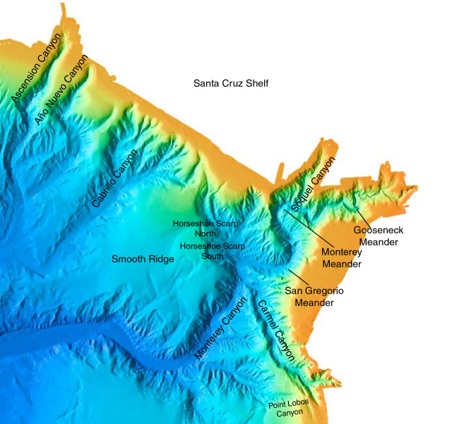
North of the Ascension-Monterey Canyon system, the Ascension continental slope is incised with many gullies but does not contain sizable submarine canyons. The multibeam data show the presence of features that appear to be rills, rotational slumps, thin sediment flows, and possible carbonate mounds scattered about the upper slope and flat outer shelf floor (Greene et al., 1999).
Many of the gullies are similar to groundwater morphology described on land (Jones, 1990). These features converge at the distal edge of the continental shelf and upper slope (100-300 meters deep) to form incipient canyons which may be associated with fluid sapping (Greene et al., 1999). Landslides are prominent along this slope. Underlying the landslides and Quaternary sediment cover are rocks of Pliocene age (Purisima Formation equivalent), Miocene age (Monterey Formation) and Jurassic Cretaceous age.
http://www.mbari.org/data/mapping/monterey/monterey.htm
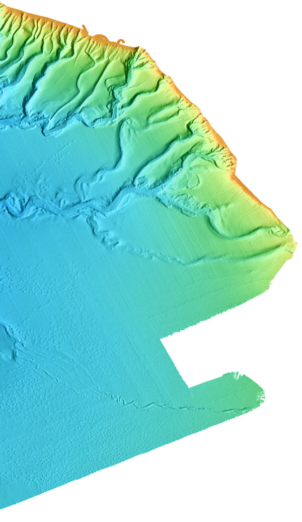
The Monterey Canyon system is composed of Soquel, Monterey, and Carmel Canyons. There are several distinct meanders, including Gooseneck, Monterey, and San Gregorio. The axis of the canyon contains a relatively flat floor that is approximately 250 meters wide with a down canyon gradient of 1.8░ and local wall gradients as steep as 33░ to 35░, but with typical wall slopes of between 10░ and 25░.
Soquel Canyon joins Monterey Canyon approximately 18 kilometers seaward of Monterey CanyonÆs head at a depth of 1,000 meters. Further offshore and approximately 30 kilometers down canyon from its head, Monterey Canyon joins Carmel Canyon in 1,970 meters of water. The headward parts of Monterey Canyon and its tributaries (less than 2,000 meters deep) generally have steep walls and narrow floors.
A fairly large field of landslides occurs along the northern wall of Monterey Canyon, at the apex of the Monterey Meander and positioned between several linear faults in the Monterey Bay fault zone. This field is composed of multiple slumps, rockfalls, and debris flows and is more than 90 square kilometers in area.
Between Soquel and Carmel Canyons, Monterey Canyon forms a broad ōSö curve consisting of two meanders (Monterey and San Gregorio meanders) and the floor continues to widen from this location down canyon. The bends are two to three kilometers in radius. San Gregorio meander (the largest in Monterey Canyon) exhibits prominent steep walls (up to 32░ in slope). This meander terminates just up canyon of the confluence with Carmel Canyon, the axis of which marks the intersection of the Palo Colorado-San Gregorio fault zone with Monterey Canyon (Greene et al., 1973, Greene, 1977; Greene and Hicks, 1990).
West (down canyon) of Carmel Canyon, Monterey CanyonÆs profile changes. The flat floor widens and becomes less v-shaped in profile. The canyon generally trends southwest from Carmel Canyon for approximately 18 kilometers to Point Lobos Canyon. Here, steep canyon walls alternate with gentle slopes and the irregular toes of landslides. Extensive areas of landsliding occur on both sides of Monterey Canyon at the bases of Smooth Ridge and Sur Slope, in an area characterized by well-defined, large individual slumps. One slide, the Sur Slide, is over 215 square kilometers in area (Normark and Gutmacher, 1988; Gutmacher and Normark, 1993).
Just down canyon from the intersection of lower Monterey and Point Lobos Canyons, a median bar has built up in the center of Monterey Canyon. Down canyon from the median bar, the canyon floor broadens to a width of about 3.5 kilometers, trends nearly due west for more than 21 kilometers, and is composed of grooves and ridges similar to fluvial-like braided drainage channels that slope off a higher northern floor. Landslides further east along the northern wall of the canyon formed a debris apron that encroaches upon the northern floor of Monterey Canyon.
Soquel Canyon is a short (9 kilometer), fairly straight arm of the upper Monterey Canyon that trends down slope southwest to intersect Monterey Canyon at 1,000 meters depth. The canyon heads into the shelf, or northern floor of Monterey Bay and is far removed from the shoreline. Soquel Canyon walls average 20░-30░ in relief and cut through the Pliocene sedimentary rocks of the Purisima Formation (Greene, 1977). At its confluence with Monterey Canyon, the channel of Soquel Canyon appears to be blocked by a slump. The walls of Soquel Canyon exhibit sharp slump scarps with slump blocks both scattered along the slopes and dropped into the canyon axis. The head of Soquel Canyon is far removed from the littoral drift, and its morphology near its head exhibits failures. These failures have been identified as block glides and previously suggested to result from fluid induced mass wasting (Sullivan, 1994; Greene, 1999).
Carmel Canyon is another relatively straight arm of the Monterey Canyon system. It has three heads. Two heads are in Carmel BayŚone at the shoreline just opposite San Jose Creek and another offshore about 3 kilometers from the mouth of Carmel River. Both cut Cretaceous granitic rocks. The third head extends along trend with the north-south oriented main canyon form, about 3 kilometers past the intersection of the other two heads. This canyon is a fault-controlled canyon, formed along the Carmel Canyon segment of the Palo Colorado-San Gregorio fault zone.
The morphology of the east and west flanks of Carmel Canyon differ. Relatively straight sloping drainage channels and slumps lightly dissect the upper eastern wall. However, the western side of the canyon is composed of steep cliffs. The eastern wall is composed of the more resistant Cretaceous granitic rocks. Based on one dredge sample, Cretaceous sandstone crops out along the western wall and apparently constitutes the bedrock ridge (Greene, 1977; Green and Hicks, 1990; Greene et al., 1991).
http://www.mbari.org/data/mapping/monterey/sur_ridge.htm
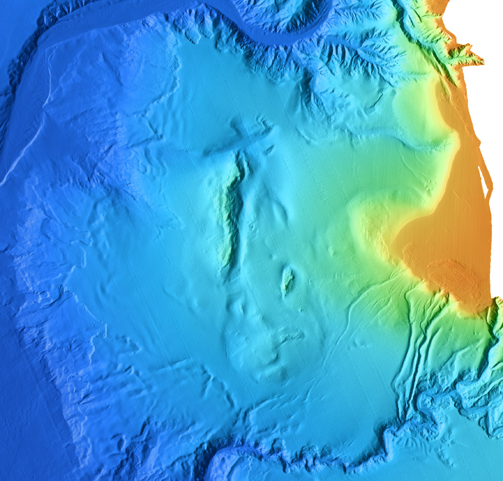
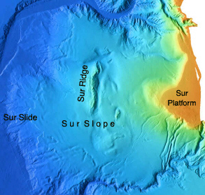
Sur Ridge, Platform, and Slope
Sur Slope is located south of the Monterey Canyon system and extends south to Sur Canyon. It has a broad half-cone shaped morphology and is capped by the Sur Platform or shelf, which separates Monterey Canyon from Sur Canyon. The Sur Platform projects seaward from Point Sur to a depth of 1,000 meters, the depth of the shelf break in this area. The upper part of the cone in the north and west has smooth topography and is relatively undissected compared to the southern part. Two prominent protrusions exist on Sur Slope and consist of Sur Ridge and Surveyor Knoll. At the northern end of Sur Ridge, a star-shaped head of a large gully is defined by the branching nature of the gullyÆs main channel, splitting into three distinct, evenly separated arms of approximately equal lengths.
A north-south lineation extends for over 50 kilometers across the lower Sur Slope. Where this lineation crosses the base of the slope, the Sur Canyon bends sharply to the south, and the western side of the canyon is comprised of a steep north-south trending cliff. This lineation is mapped as a fault and appears to control the east facing cliff and trough morphology of Sur Ridge. It appears to continue northward to the star-shaped head gully.
The western part of the Sur Slope steepens, and landslide scars are prominent from 1,500 to 3,000 meter depths. This major field of landsliding extends from Monterey Canyon to Sur Canyon and covers an area of more than 880 square kilometers. Within this field individual scars can be identified which range from less than 0.5 square kilometers to more than 11 square kilometers in area. Potential areas of composite slumping cover areas as big as 55 square kilometers. The largest scar was mapped and named Sur Slide by Normark and Gutmacher (1988).
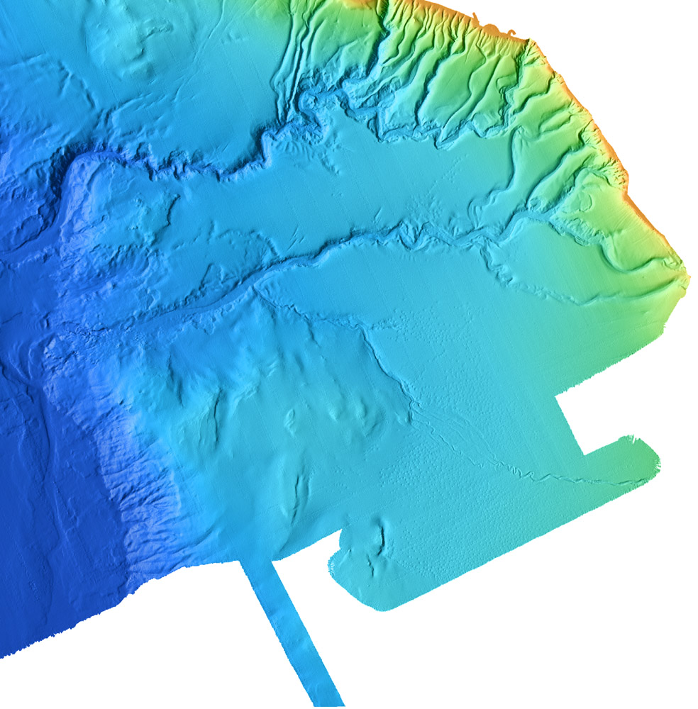
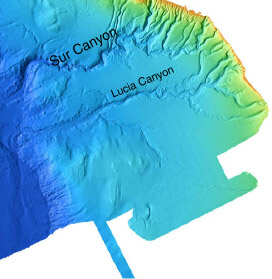
Sur Canyon
Sur Canyon is located approximately 60 kilometers south of the head of Monterey Canyon. Its multiple heads notch the southern part of the Sur Platform. Sur Canyon is sinuous but generally trends west for more than 50 kilometers from its head to where its main channel sharply bends south and its floor broadens.
There are four major meandersŚtwo near the head of the Sur Canyon main channel in approximately 1,000 meter water depth and two farther down canyon in approximately 1,500 meters of water. The floor of the canyon averages about 0.25 kilometers in width from the upper meanders to the down canyon bend, where the channel widens considerably to approximately 0.75 kilometers.
Four very straight, south-trending channels (or chutes) are present above and to the west of a fairly extensive (95 square kilometers) landslide field located just north of the upper meanders. One chute enters the head of the landslide field, and the others enter the main channel of Sur Canyon. All extend up to the flat shelf floor of the Sur Platform.
Landslides are prominent along the Sur Canyon, with well-defined slumps and flows concentrated along the northern wall of the canyon in the vicinity of the upper meanders as well as in the lower part of the canyon. Down canyon (at 1,500 meters), the Sur Canyon channel winds sinuously through steep walls. Several small slumps exist along this stretch of canyon, but mass failures appear considerably less prominent than elsewhere along the canyon.
http://www.mbari.org/data/mapping/monterey/upper_lucia.htm
A 560 square kilometer pockmark field containing approximately 1,500 individual depressions lies to the south of the Sur and Lucia Canyons. These features occur on a slope platform at depths ranging from 900 meters to 1,200 meters. The pockmarks have irregular circular rims and cross-sectional profiles resembling an inverted cone with inward dipping slopes of 5░ to 6░. Diameters range from 130 meters to 260 meters, and depths from rim to bottom range from 8-12 meters, with the typical pockmark being 200 meters across and 10 meters deep. Pockmark densities range from 1.5/km2 in the north increasing to 6/km2 in the south. The southern extent of the pockmark field is unknown but almost certainly extends beyond the southern edge of the surveyed area.
A levied channel with associated overbank deposits and abandoned channel scars bisects the pockmark field in an east-west direction. The overbank deposits appear to have obliterated previously existing pocks, while newer pocks form linear strings along partly buried older channels. Elsewhere they are distributed so as to maintain some optimum distance from each other, and only rarely do two or more pockmarks coalesce (Maher et al., 1998).
http://www.mbari.org/data/mapping/monterey/shepard.htm
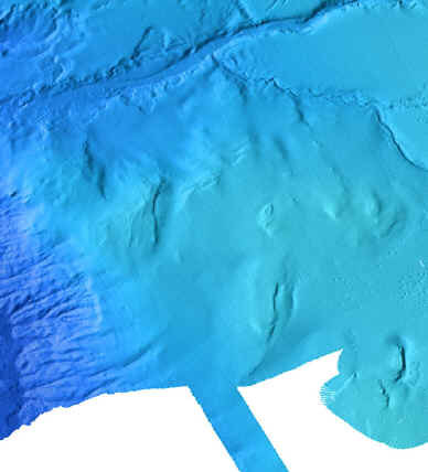
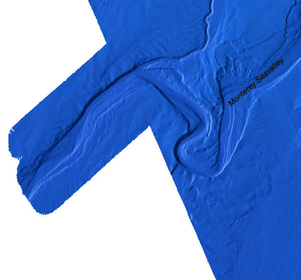
Just below the base of the continental slope, directly offshore (west) of the Sur Platform, an oxbow meander occurs in the upper part of Monterey Seavalley. Northeast of this meander the floor of Monterey Seavalley is wide (3.5 kilometers), trending generally southwest. Prior to entering the meander, the seavalley trends almost due south, forming the upstream leg of the meander.
From the bend marking the start of the meander, the upstream leg is remarkably straight and trends nearly due south for over 12.5 kilometers, then sharply bends to the northwest (nearly a 110░ bend). The active channel slips off a gentle, westerly dipping high along the eastern channel floor to occupy a thalweg that is located along the base of a 100 meter high erosional scarp. Just below the bend that denotes the beginning of the upstream leg, on the western or cut bank side of the channel, a pronounced 0.5-kilometer-wide by 1-kilometer-long re-entrant basin with a 50 meter headscarp and flat floor cuts into the neck of the meander. A short distance downstream from the re-entrant basin a landslide is also cutting into the neck of the meander.
Farther along the western wall of the upstream leg of the meander, several landslides occur. The elongation of the slides appear to align with a relic flow channel that curves along the distal margin of the meander.
The headward leg of the meander and the headward scarp of the spur are both 8 kilometers long. The drop in depth of the active channel floor here is from 3,420 meters to 3,460 meters, a total of 40 meters. The cut bank consists of a 150-100 meter scarp on the upstream (south) curve and a 300 meter scarp on the downstream (west) curve. These scarps are connected by a gentle 50 meter high scarplet that is cut into the toes of two landslides. The northern, or inside, wall of the channel is a 100 meter high, very gently dipping, headward slope of the meander curve. This slope steepens and increases to about 150 meters in height opposite the downstream cut bank.
The downstream leg of the meander bends back into the meander spur trending northeast for a distant of about 7 kilometers, where the channel makes its closest approach to the upstream leg. In this stretch the cut bank along the western side of the channel ranges from a 300 meter high steep cliff at the upstream curve to a gentle slopping 60 meter high bank near the downstream end of the leg. The inside bank (southeast side) is a gently dipping 100 meter bank that gives way to a flat 0.25-kilometer-wide channel terrace platform at the downstream bend or end of the leg. At the downstream edge of the terrace platform, a landslide occurs in the meander spur deposits.
The last bend in the meander changes the trend of the channel from northeast to northwest, a 90░ turn. A point bar-like feature exists at this turn and bounds the channel on the southwest for about 8 kilometers of the 15 kilometer long stretch. The point bar is backed by a 100 meter high erosional scarp.
The northeastern wall of the northwesterly trending channel is a 200-meter-high, steep erosional cliff that extends from the terrace platform at the last meander bend for about 5.5 kilometers, to where the cliff becomes a very gently dipping bank prone to landsliding. Above this cliff and bank is a flat, older channel terrace platform.
At the end of the northwest trending channel, the seavalley takes another 90 degree turn to trend southwest. Here a point bar is again built out along the inside or southeastern margin of the channel. This bar continues back upstream around the bend to form the last 4 kilometers of channel bank along the southeastern side of the northwesterly trending channel.
http://www.mbari.org/benthic/coldseeps.htm
http://www.mbari.org/benthic/Physiologicaladaptationofclams.htm
Physiological adaptations of the vesicomyid clams living at Monterey Bay cold seeps.
-Shana Goffredi, Ph.D.-
Monterey Bay Aquarium Research Institute
Backg
Davidson Seamount
Guide Seamount
Monterey Canyon
Bentos
Factors regulating productivity in chemoautotrophic symbioses