 | Navajo Volcanic Field |
|
Navajo Volcanic Field. Schematic diagram of the diatremes of the Navajo Volcanic Field clustered around the Four Corners region.The letters identify diatremes: ME, Mules Ear; MR, Moses Rock; CV, Cane Valley; GR, Garnet Ridge; RM, Red Mesa; GN, Green Knobs; BP, Buell Park; AG, Agathla; CR, Church Rock; SR, Ship Rock; MR, Mitten Rock;RB, Roof Butte; WP, Washington Pass; FR, Fluted Rock; TB, Twin Buttes. Map from Roden and Smith (1979)- http://written-in-stone-seen-through-my-lens.blogspot.com/2011/01/ship-rock.html |
NVF -diatremas and monoclines. Map of the central Navajo Volcanic Field. Notice clustering of volcanic structures along Laramide-age monoclines. Dark circles indi¼cate minettes; open triangles represent SUMs. Monoclines are indicated by heavy lines. Abbreviations: AP, Agathla Peak; AZ, Arizona; BB, Boundary Butte; BP, Buell Park; CO, Colorado; CRM, Comb Ridge Monocline; CV, Cane Valley; EDM, East Defiance Monocline; GN, Green Knobs; GR, Garnet Ridge; ME, Mule Ear; MHM, Mesaverde Hogback Monocline, MR, Moses Rock; NM, New Mexico; RM, Red Mesa; SR, Ship Rock; UT, Utah. Major communities are also shown. After Smith and Levy (1976) and McGetchin et al. (1977).- http://written-in-stone-seen-through-my-lens.blogspot.com/2011/01/ship-rock.html |
NVF, Ship rocks, New Mexico - http://www.nmnaturalhistory.org/chuska-ship-rock-navajo-field.html |
NVF - diatreme. From "Maar-Diatreme Volcanoes..." by Lorenz |
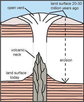
NVF -diatreme and maar crater. Diagram of a diatreme with its maar-crater illustrating its exhumed position (land surface today) http://written-in-stone-seen-through-my-lens.blogspot.com/2011/01/ship-rock.html |
.Monument Valley Landscape Gypsum Creek Dome. From left are the Three Sisters and Mitchell Mesa, Gray Whiskers and Mitchell Butte |
Black Mesa |
NVF -This is a closer view of the Mule Ear (left) and the Mule Ear diatreme (center and right) taken from the San Juan River as it heads south just before turning to the west and heading into Lime Ridge and the Raplee Anticline - http://written-in-stone-seen-through-my-lens.blogspot.com/2011/01/ship-rock.html |
NVF. From the crest of Comb Ridge looking south into Comb Wash and the San Juan River (17 km to the east of Gooseneck State Park), the Mule Ear, a resistance flank of Comb Ridge, points skyward with the eroded remnants of the Mule Ear diatreme situated to the right in the strike valley. The diatreme is positioned within the eroded eastern flank of the Laramide-age Monument Upwarp. Interestingly, the Mule Ear''s prominence above Comb Ridge, of identical sedimentary composition, may be related to it having been subjected to low grade metamorphism from the neighboring diatreme which conferred a resistance to erosion - http://written-in-stone-seen-through-my-lens.blogspot.com/2011/01/ship-rock.html |
NVF. Alhambra Rock. San Juan County, southeastern Utah Looking south-southeast from Goosenecks State Park near Mexican Hat, New Mexico, this exhumed diatreme is called Alhambra Rock. Typical of other Navajo Volcanic Field diatremes, erosion has left the resistant neck standing as a lone sentinel. In the foreground, erosion has exposed the Pennsylvanian rocks of the Hermosa Group''s Honaker Trail Formation within the Goosenecks of the San Juan River. Alhambra is framed against Comb Ridge in the distance, the eroded, upturned eastern limb of the Monument Upwarp- http://written-in-stone-seen-through-my-lens.blogspot.com/2011/01/ship-rock.html. |
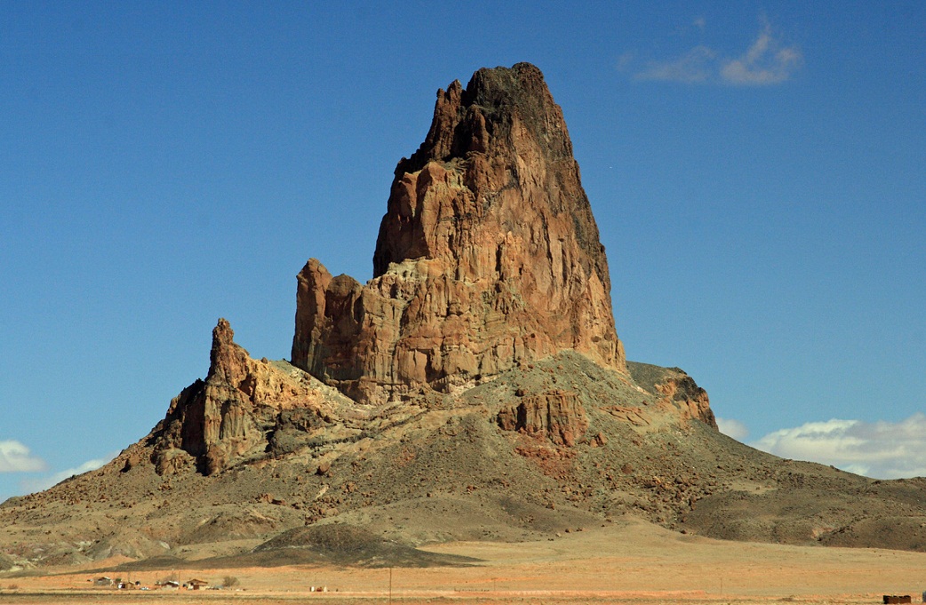
Agathla Peak an old volcanic plug outside of Kayenta Arizona |
Agathla Peak |
El Capitan |
|
Church Rock |
Chaistla Butte |
NVF. A fortuitous break in the clouds allowed the sun to illuminate the two black monoliths, reflecting back as an unearthly, metallic-white gleaming in the high desert. Typically, radial dikes can be seen to emanate outward from the base of Ship Rock on the desert floor. Dikes are magma-filled fractures in the EarthÆs crust that serve as conduits for molten rock. There is also a smaller diatreme juxtaposed in the foreground called The Thumb. -Differential erosion has left Ship Rock and the Thumb towering above the surrounding plains. Interestingly, the Chuska Mountains are "held up" (and hence created) by a lava flow of the same geological ilk that created other volcanics within the region, but here, a trachybasalt which is the extrusive equivalent of minette (please read on). The resistant igneous rock prevented the Chuska''s from eroding, while the neighboring regions of the plateau were unroofed. Seen in the photo, the pass was covered by the flow''s underlying Chuska Sandstone http://written-in-stone-seen-through-my-lens.blogspot.com/2011/01/ship-rock.html |
NVF. Somewhat north of Monument Valley, is this small, possibly unnamed diatreme. Notice the remnants of its dike running off to the right projecting vertically through the strata that it dissected. -http://written-in-stone-seen-through-my-lens.blogspot.com/2011/01/ship-rock.html |
Shiprock - The Beast, an isolated intrusion, is typical of the scattered smaller volcanic intrusions throughout the Navajo volcanic field.-http://www.nmnaturalhistory.org/chuska-ship-rock-navajo-field.html |
Garnet Ridge |
Erratics, Garnet Ridge, Apache County, Arizona, Canyon de Chelly quadrangle. August, 1914 |
Erratics, Garnet Ridge, Apache County, Arizona, Canyon de Chelly quadrangle. August, 1914 |
Boulders of granite, Garnet Ridge, Apache County, Arizona |
Three Pyropes from Garnet Ridge, Arizona, USA. As their chromium content increases clockwise from the upper right, the amount of purple component increases -http://minerals.gps.caltech.edu/ge114/lecture_topics/garnets/index.htm |
Outlet of Buell Park, looking down stream, Apache County, Arizona 1909 |
Pyrope,Buell Park diatreme, Buell Park, Apache Co., Arizona, USA |
Buell Park, Arizona Topographic Map -http://www.topoquest.com/map-detail.php?usgs_cell_id=5992 |
NVF, NM |
http://www.nmnaturalhistory.org/chuska-ship-rock-navajo-field.html |
Black Rock volcanic neck, Redrock Valley, Apache County,. Ship RockThe surrounding rocks are Triassic- to Jurassic-aged redbeds (= hematite-rich siliciclastic sedimentary rocks). - http://www.newark.osu.edu/facultystaff/personal/jstjohn/Documents/Rocks-and-Fossils-in-the-Field/Navajo-Volcanic-Field.htm |
Upheaval Dome in Canyonlands National Park,Ut. The creation of Upheaval Dome, in Canyonlands National Park, Utah, has long confounded geologists. This giant circular hole in the Utah desert is actually a structural dome with an eroded central region caused by weaker, older rocks (possible salt) at the center of the dome. It has long been debated whether the dome represents the long-term effects of salt diapirism in the Paradox Basin or a meteorite impact scar. Recent work seems to support the meteorite impact hypothesis. Our work suggests that Upheaval Dome represents the end-result of a long history of deformation that was triggered by a meteorite impact but subsequently evolved as salt diapirism continued below the original impact site. We have undertaken detailed field mapping of structural features as well as thin-section petrographic work to unravel the mechanics of disparate deformation styles present in the rock units around the dome - http://southwestdesertlover.wordpress.com/tag/upheaval-dome-in-canyonlands-national-park/ |
Upheaval Dome in Canyonlands National Park http://southwestdesertlover.wordpress.com/tag/upheaval-dome-in-canyonlands-national-park/ |
http://www.nationalparkstraveler.com/2008/03/researchers-say-meteorite-impact-created-upheaval-dome-canyonlands-national-park |
See http://plate-tectonic.narod.ru/monumentvalleyphotoalbum.html
See site of Dr.Jack Share -http://written-in-stone-seen-through-my-lens.blogspot.com/2011/01/ship-rock.html
Ceology
Buell Mountain USGS Buell Park Quad, AZ,NM, Topographic Map
Ship Rock area
Monument Valley


