 | Morro Bay окрестности |
Overview Map of Nine Sisters Volcanic Chain. Между 20 и 27 MA под’ем магмы через кору произвел цепь из 14 вулканов, простирающихся от Морро-Бэй до Сан-Луис-Обиспо. Bулканы этой цепи существовали в середине кайнозойского времени, сегодня это некки и куполa, ядрa или жерлa вулкана. Bулканы были активны во время, когда тройное соединение Мендосино еще не мигрировалo к северу. Тройное соединение помогло начать вулканическую активность, потому что незначительные различия в направлении движения плиты, возможно, обрaзoвaли переломы, через которые магма могла остигнyть поверхности |
Cerro San Luis (San Luis Mountain) |
Madonna Mountains |
Cerro San Luis Obispo Laguna Lake Park |
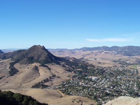
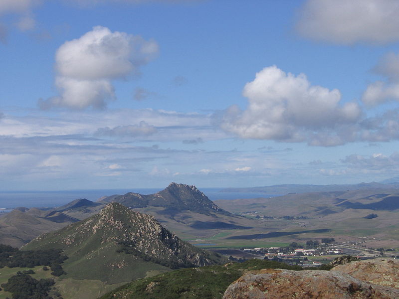
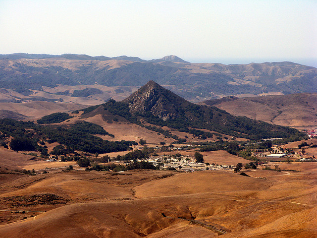
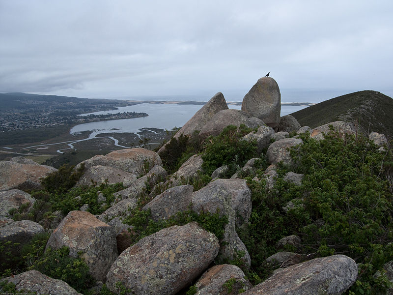
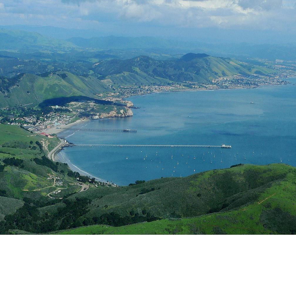
The view from the top of Bishop Peak looking towards Morro Rock. Dacite vilcanoes. - http://en.wikipedia.org/wiki/Nine_Sisters |
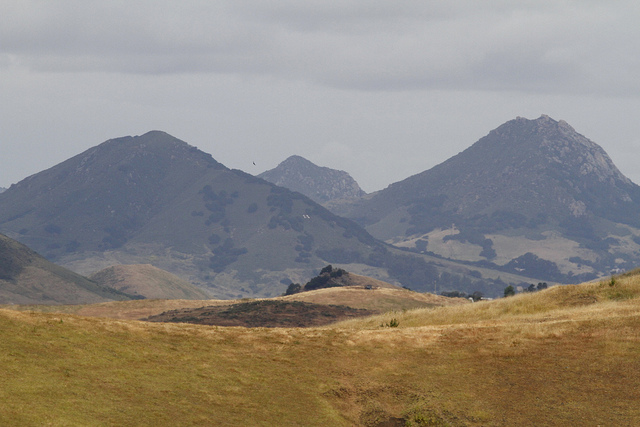
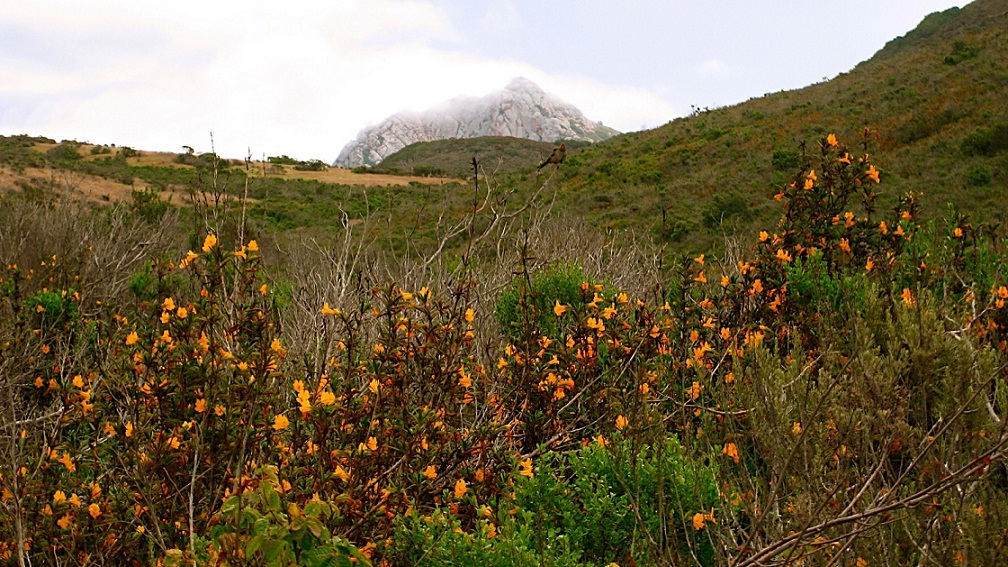
Nine sisters - miocene volcanic chane remnants. The Nine Sisters or the Morros are a chain of nine volcanic peaks and hills between Morro Bay and San Luis Obispo, California. They support a wide variety of plant, animal, and bird life.Dacite - http://en.wikipedia.org/wiki/Nine_Sisters |
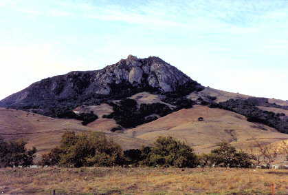
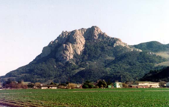
Bishop Peak , Santa Lusia Range, the highest of all the peaks, rises 500m above the sea. The rocky outcroppings makes it one of the most distinguishable of all the peaks. John Muir, founder of the Sierra Club, made a note in his travel diary while descending from Cuesta Grade.The peaks were created over 20 MAas volcanic plugs of magma which welled up and solidified inside softer rock which has since been eroded. The highest peak is Bishop Peak at 475 m. Like the other Morros, Bishop Peak is primarily composed of dacite. Over 20 MA magma welled up underneath a layer of softer rock and solidified. The softer overlying rock has since eroded away, leaving a distinct rugged shape. - http://en.wikipedia.org/wiki/Bishop_Peak_(California) |
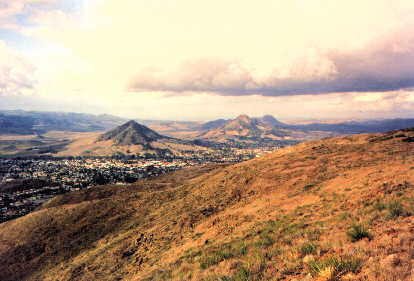
Hollister Peak Viewed From Highway 1- http://santalucia.sierraclub.org/ninesis.html |
Cerro Romauldo |
Cerro San Luis, Chumash Peak, Bishop Peak |
slay Hill, one of the Morros, is an old volcanic cone situated on the south side of the city, roughly between the airport and Orcutt Road. Its north flank was dedicated as open space in the 1980’s as housing construction began on Tank Farm Road. You will find the official trailhead at the end of a cul-de-sac called Sweetbay, accessed from Tank Farm Road via Wavertree and Spanish Oaks. The Rodriguez Adobe, dating back a century and a half, has been recently remodeled as reminder of the original use of this land. With a 400’ altitude gain, Islay Hill .- http://santalucia.sierraclub.org/Islaytrail.html |
Chumash Peak is the middle of the three peaks - http://en.wikipedia.org/wiki/Chumash_Peak |
Chumash peak |
Cabrillo Peak |
Summit of Cerro Cabrillo (Cerro_Peak) |
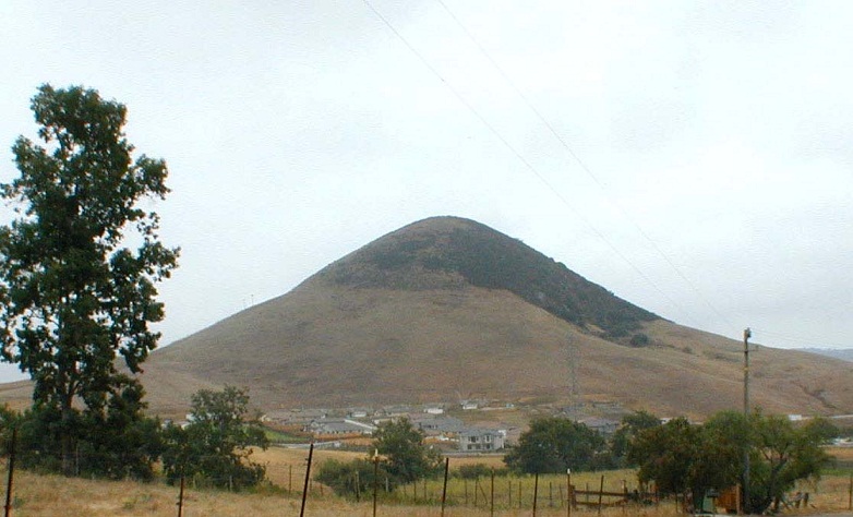
Black Hill, with an elevation of over 200m, is located in Morro Bay State Park. It is rumored Black Hill got its name from a tar seep on the north side of the hill. Many years ago, John Fleming, former parks superintendent, was working on several conservation projects planting Penny Pines. To make sure he had enough pines to do the job, he ordered twice as many as required, fearing he would only receive half of what he needed. When the pines were delivered, he received all he had ordered. The extra pines were planted on Black Hill, creating Fleming''s Forest. The pines have since spread to nearby Turtle Rock, creating a wonderful habitat for many bird species and owls. |
Portola Point |
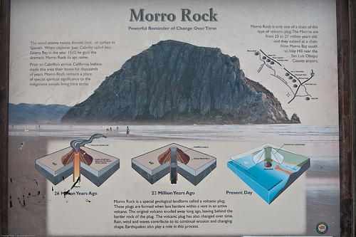
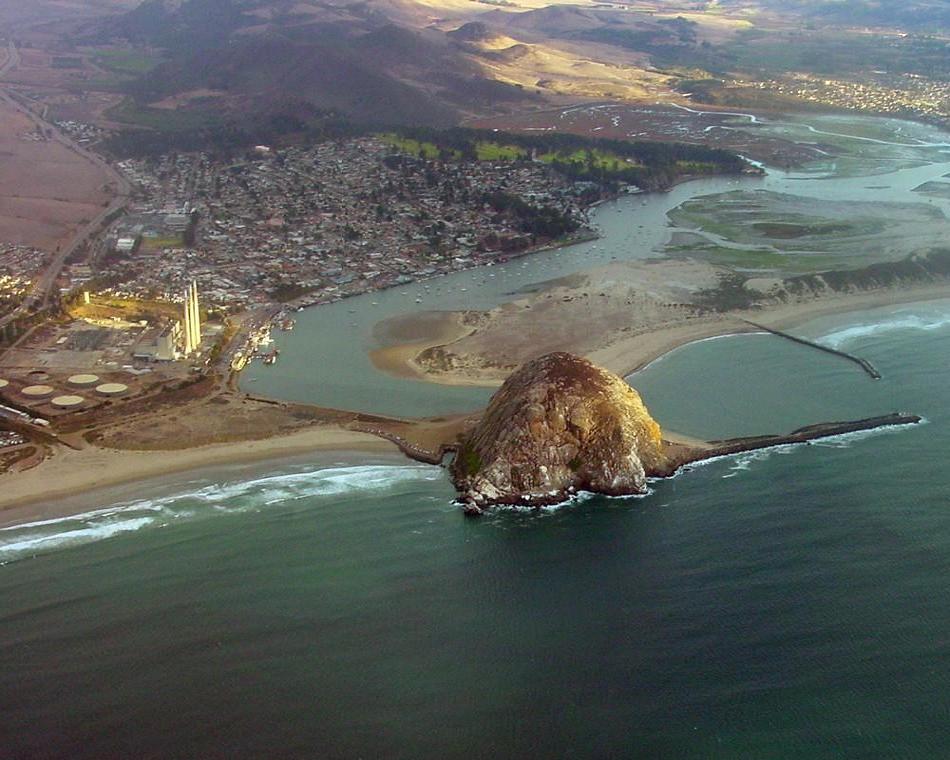
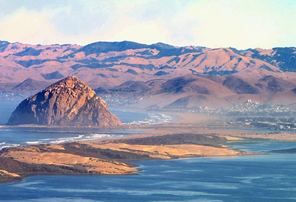
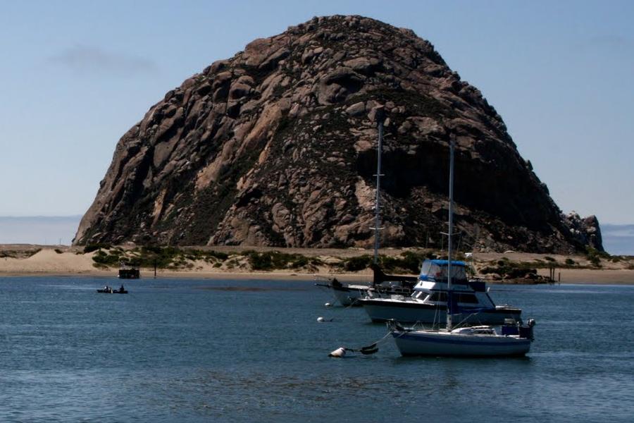
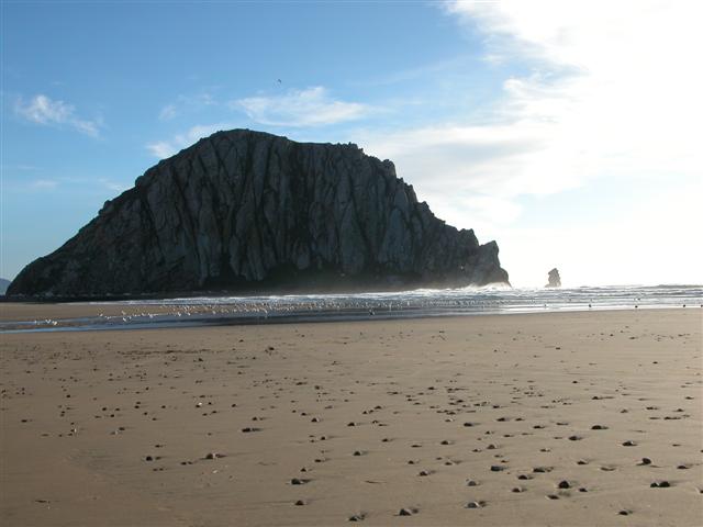
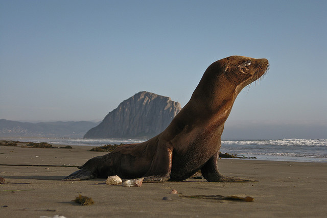
Скала Morro -"Гибралтар Тихого океана", является 578-м вулканoм в цепочке древних вулканических останцов |
Morro Rock |
Morro Rock |
Morro Rock.The softer overlying rock has eroded away over the years, leaving the dacite |
Morro Rock north. Morro Rock is a 177 m volcanic plug located just offshore from Morro Bay, California, at the entrance to Morro Bay Harborhttp://en.wikipedia.org/wiki/Morro_Rock. |
Morro Rock north |
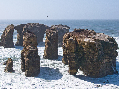
Point Buchon Trail |
Avila Beach -south of Montana de Oro |
Avila Beach |
|
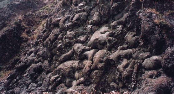
Юрскиe базальты подушечныx лав в Авила-Бич, Калифорния.Невзрывные потоки лавы обычно формируют под водой подушечные лавы или подушечные обломочные брекчии и при взаимодействии лавы и воды производятcя фрагменты, известные как гидрокластиты. Исторически имя "гидрокластиты" относится к породам, богатым быстро охлажденными стеклянными частицами, произведенными в ходе невзрывчатoo spalling и гранулированиым коркaм подушечныx лав (Риттман, 1958) |


1. FIELD STUDY San Luis Obispo, CA By Sarah Diekneite
2. Bishop’s Peak What: A dormant volcano that is now an extremely popular hiking spot Who: Partially owned by the Bishop Peak National Reserve and the Sierra Club Where: The central coast town of San Luis Obispo, CA When: The mountain was formed 20 million years ago. It was bought by the Bishop Peak National Reserve in 1977. ( Felsman, 2008) Exploration site: The tallest of the “Nine Sisters”
3. History: Bishop’s Peak 20-25 million years ago, a chain of volcanic plugs, commonly referred to as the “Nine Sisters” were formed between Morro Bay and San Luis Obispo, CA Subduction occurred as the widening Atlantic Ocean pushed North America A June 1992 records check with the California Archaeological information Center (UCSB) confirmed that mortar sites exist throughout the high meadows of Bishop Peak. ( Felsman, 2008) View from halfway up Bishop’s
4. Bishop’s Geological Formations Because it is so weathered, the rocks of Bishop’s Peak appear to be whitish granite, but are actually gray and contain a type of silica called Rhyodacite Weathering over the past millions of years has cracked the mountain in many places, especially near the top, causing boulders and land slides. This means that the present peak is now a lot shorter than it used to be. ( Felsman, 2008) Many dike injections of magma can be noticed throughout all of the “Nine Sisters,” especially in Bishop’s. ( Felsman, 2008) Other volcanic features are present on the sides of the peak as well, including landslides, avalanches, and exfoliation weathering.
5. Dacite Dacite is an igneous, volcanic rock. It is composed of Andesite and Rhyolite. Bishop Peak is primarily composed of dacite. Magma from its days as a volcano welled up underneath a layer of softer rock and solidified. The softer overlying rock has eroded away over the years, leaving the dacite.
6. Serpentine Serpentine is a metamorphic rock that is formed at low-temperatures. It is created through a reaction involving heat and water in which low-silica mafic and ultramafic rocks are oxidized. Serpentine is the second most common rock found on the “Nine Sisters.” I was lucky enough to find one large sample on the peak, and also some stones of Serpentine at the Learning Pine Arboretum.
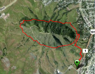
7. Bishop’s Peak Today 1,559 feet above the sea. Currently, there are three main trailheads On February 15, 1968, succeeded in obtaining its designation as State Historical Landmark #821. The Peak is in danger from hikers and climbers making their own paths, which leads to excess erosion Animals such as mountain lions, coyotes, bobcats, deer, turtles, frogs, and Garter snakes are very common ( Ernest & Allen, 1995) Vegetation includes grassland, oak woodland, and chaparral that provide a wide range of habitats.
8. The Learning Pine Arboretum Exploration site: Cal Poly, San Luis Obispo What: An outdoor “living laboratory” of beautiful and interesting landscape plants Who: Run by the Environmental Horticultural Science facility Where: Located on five acres of Cal Poly’s campus, overlooking the Santa Lucia Mountains When: I visited on July 22, 2011 Why: To display sunning landscapes teach about plants from around the globe
9. Overview: The Arboretum The Arboretum is nestled on a plot of rich soil, surrounded by natural, medium sized mountains The natural landscape includes many types of rock formations, nonswampy plants and trees (specifically lots of oak), and short, dry shrubs.
10. Aloe plants are also referred to as the “healing plant” They can live for up to 25 years ( Aloe plant information, 2011 ) Its leaves are extremely succulent, absorbing and containing juices known best for helping to heal burns Aloe
11. California Buckeye Tree The California Buckeye tree’s scientific name is Aesculus californica It is very unique in that it loses its leaves during the summer, rather than in the fall In the winter, it regains its bright green leaves In the spring, it produces plumes of white and pink flowers
12. Yellow Swallowtail Yellow Swallowtails are extremely common, found on every continent except Antarctica They come from the butterfly family Papilionidae . There are currently 550 known species in the Papilionidae family (Dodie, 2004) This particular specimen had a wingspan of approximately three or four inches wide, when fully opened.
13. Citations Aloe plant information . (2011). Retrieved from http: //freealoeplant .tripod.com/ Dodie. (2004). Yellow swallowtail butterflies . Retrieved from http://www.nature-and-flower-pictures.com/yellow-swallowtail-butterflies.html Ernest & Allen. (1995). History of morro rock and the nine sisters . Retrieved from http://www.morrobay.com/rock.htm Felsman, G. (2008). The nine sisters of san luis obispo county . Retrieved from http://santalucia.sierraclub.org/ninesis.html Picture Links: http: //detailsinlandscape . com/about_us http://www. rockclimbing .com/images/photos/assets/6/269246-largest_5736.jpg
from http://www.slideshare.net/sarahclaire110/field-study-in-san-luis-obispo
Geological Features of the Nine Sisters
The chain of volcanic plugs called the Nine Sisters were formed about 20-25 million years ago. At that time there was a significant event in the history of the continent. North America, drifting westward as the Atlantic widened, had for over 100 million years been overriding the Pacific sea floor, forcing the rocks down under its western edge where they melted and merged back into the mantle. The churned geologic debris of the ''subduction'' process is represented in the chaotic melanges of the Franciscan Formation that flanks the plugs. Then, at the time the plugs themselves were formed, the western continental edge collided with an ocean ridge system, causing a major change in the forces acting on the crust. Compressive forces became tensional, rocks that had been solid melted, and the magmas oozed to the surface.
Following either the lines of existing faults, or perhaps guided slabs of rock in the sheared debris of odd ocean floor material that dominated the coastal areas, the magma''s rise was confined to a narrow linear zone. At the surface there would have been a line of volcanoes, all of which have vanished, stripped away by millions of years of erosion from the coastal stream that presently flank the chain of hills.
The present peaks are the plugs of congealed lava that filled the deep parts of vents for those volcanoes. Once totally encased by the older Franciscan Formation ''melanges'' through which they were intruded, they are now exposed as those older but softer rocks are washed to the sea. The volcanic rock looks a little like granite in its whitish weathered state, but its true color is the gray of rocks with a lesser silica content called rhyodacite. Close observation reveals that the magma must have been almost solid as it rose through some of these events, a sort of geologic toothpaste. Weathering has cut and widened cracks into chasms on their surfaces, making the tops of some appear like a montage of boulders. Some of the peaks were doubtless much taller until comparatively recent times, from the testimony of large landslide and avalanche deposits of their flanks.
The magmatic intrusions mark the end of subduction and the birth of a new stress and faulting regime along the western edge of North America known today as the San Andreas fault system. The peaks and the Franciscan Formation in which they stand have a long story to tell us, a story that is unique in California.
There are rocks of similar age and type elsewhere in the United States, but few can be seen with ease from a paved highway. These peaks are great illustrations of the process of dike injection of magma, of the shape and form of dikes, of the movement of viscous, semi-solid magmas, of exfoliation weathering, and other volcanic features. The surrounding Franciscan melanges allow for easy inspection of the dependence of soil formation on rock type, and also illustrate very well the process of landslide and earth flow. They are also the markers of a turning point in the geologic history of the west.
The connecting ridges between the volcanic plugs consist of various rock types from the Franciscan Formation. The most impressive is the narrow ridge of serpentinite between Hollister Peak and Cerro Romauldo, and some similar serpentinite ridge spurs at the eastern edge of the chain. The serpentinite hills are conspicuously bare of vegetation, a product of the lack of certain chemical elements in serpentinite soils. The strange chemistry born of the metamorphic processes that converted peridotite like igneous rocks to serpentinite, also has produced a number of rare plants. The peridotite is thought to have once been the base of oceanic crust that smashed into the subduction zone. Other common rock types are redrock and basalt, the former being a decomposed variety of the latter.
Volcanoes
Fild study of San Luis Obispo Nine Sisters
Nine Sisters
Davidson Seamount