 | Plume tectonics and Supercontinents |
Velocity Structure of the Earth, Spheres of the Earth. The phenomenon of plate tectonics gives evidence of sources of energy within the Earth. Although the Earth''s heat output each day is much smaller than the amount of solar energy it receives, it is enough to build mountains that resist the solar-driven processes of erosion. To understand how plate tectonics works, we must understand the nature of the Earth''s interior.(J. Louie) Above is a simplified view of the composition and state of regions within the Earth. Note how the regions are arranged in radial shells. Compositions and properties vary vetween shells a great deal, while relatively little within any one shell. While planetary physics, the properties of the geomagnetic field, Earth''s gravity field, tides, geochemistry, and geology all contribute to knowledge of the Earth''s interior, defining and characterizing the layers of the Earth has basically been the business of earthquake seismologists http://crack.seismo.unr.edu/ftp/pub/louie/class/plate/velocity.html |
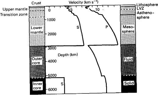
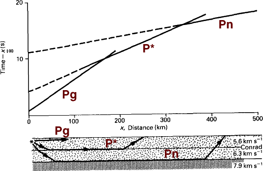
Velocity Structure of the Earth, Spheres of the Earth. (from Kearey & Vine, copyright Blackwell Sci. Publ.) Timing of the arrivals of seismic waves is, of course, most sensitive to the velocity property of the materials encountered. While other properties, such as incompressibility, rigidity, and density may be inferred from velocities, only velocities can be measured accurately and directly. Note how the transitions between layers show both gradients and discontinuities: Discontinuities arise at changes in composition. Steep gradients arise at changes to denser, tougher phases (having the same chemical composition), or perhaps at changes in temperature (convection boundary layers) or composition. Shallow gradients arise where the same phases and assemblages of minerals undergo velocity increase with pressure concurrently with velocity decrease with temperature, as depth increases. A slow rise in velocity results http://crack.seismo.unr.edu/ftp/pub/louie/class/plate/velocity.html Earth Discontinuities : 5144 km Lehman - Fe solid against FeO, FeS fluid; 2885km Gutenberg - fluid FeO, FeS against Mg,Fe)silicates,velocity decrease, density increase; 2870km D'''' - thin, mixing of mantle and core material?; "670 km" - worldwide, no earthquakes deeper, debates over whether a composition, phase, or viscosity change; "400 km" - worldwide, structure more variable above, phase change to spinels; 50-200 km LVZ - really a couple of gradients, regionally variable; 4-55 km Moho - sharp compositional change to crust,tectonically active?; 5-30 km Conrad - mafic to felsic crust,often absent |
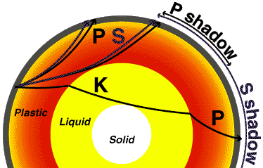
Velocity Structure of the Earth, Spheres of the Earth. J. Louie) Beno Guterberg located the core-mantle boundary from the P-wave shadow zone, where P-waves are bent away from the boundary, and from the larger S-wave shadow zone, showing that the core is fluid.http://crack.seismo.unr.edu/ftp/pub/louie/class/plate/velocity.html |
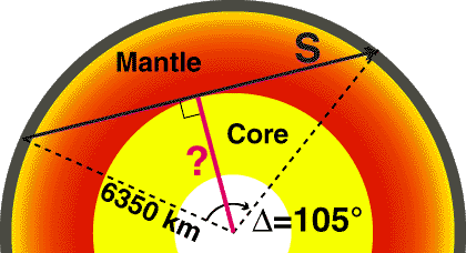
Velocity Structure of the Earth, Spheres of the Earth. J. Louie) Just by knowing the delta degree angle of the onset of the S-wave shadow zone, and the radius of the Earth, you can make a simple estimate of the radius of the core.http://crack.seismo.unr.edu/ftp/pub/louie/class/plate/velocity.html |
http://crack.seismo.unr.edu/ftp/pub/louie/class/plate/velocity.html |
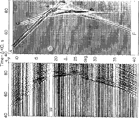
In her thesis Maryanne Walck used these data and synthetics to control the steepness of the gradients at the 400 and 670 km discontinuities below the Gulf of California. The t-x diagrams have been skewed by a reduced time t - t * 10 (km/s), for presentation, so velocities less than 10 km/s tilt left, and more than 10 km/s tilt right. Walck estimated the 400 km discontinuity to be a shallow-gradient phase change, while the 670 km discontinuity had the steep-gradient character of a compositional change-http://crack.seismo.unr.edu/ftp/pub/louie/class/plate/velocity.html |
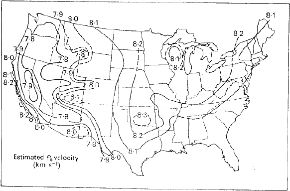
The above methods assume a purely radial or layered symmetry, with no lateral discontinuities. Repeated, localized experiments can show general changes, as in the thickness of the crust, as long as the experiments did not intersect any lateral transition |
This map of velocity just below the Moho was contoured from many localized experiments around the 48 states. The higher velocities below the Sierras are an artifact of the experiments'' spanning a lateral discontinuity-http://crack.seismo.unr.edu/ftp/pub/louie/class/plate/velocity.html |
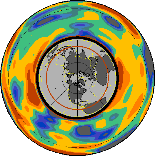
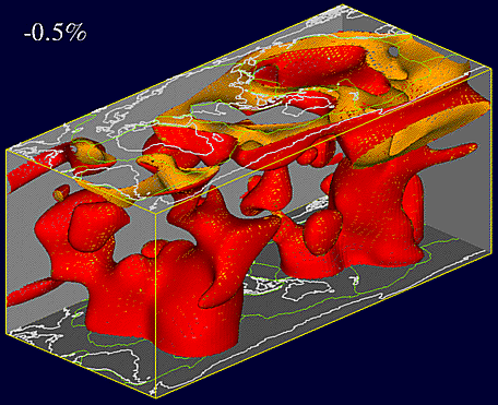
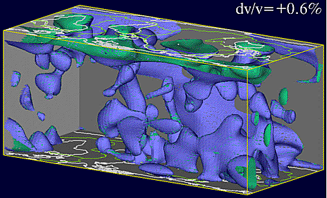
Tomography is the reconstruction of an image from its projections, or shadows. Above is a tomographic inversion result for a section of the Earth''s mantle, at the equator. Cool colors represent represent positive deviations of velocity from the radially-symmetric average at that depth, and warm colors represent negative velocity deviations. Since the mantle has a nearly constant composition, velocity deviations are thought to be due to differences in temperature, with cool colors for fast cold mantle and warm colors for slow warm mantle. The dashed circle is the 670 km discontinuity; plate boundaries are yellow on the index map at center.http://crack.seismo.unr.edu/ftp/pub/louie/class/plate/velocity.html |
Tomography is the reconstruction of an image from its projections, or shadows. Warm, viscous parts of the mantle are less dense than their surroundings and will rise buoyantly over geologic time (as fast as your fingernails grow). Relatively cold mantle will sink. Driven by heat escaping the core, and cooled in the oceans, the mantle will circulate or convect, just like a boiling pot. A complete turnover takes hundreds of millions of years. The interiors of all planet-sized bodies must be actively convecting, to release their heat of formation. Any planet with a radius over ~1500 km cannot conduct its internal heat away within the age of the universe, so it must convect viscously to release its heat, or it would melt and then convect as a fluidcenter. A 3-d view of a mercator projection of the mantle, with orange surfaces surrounding warm blobs of mantle, which should be rising plumes. http://crack.seismo.unr.edu/ftp/pub/louie/class/plate/velocity.html |
Tomography is the reconstruction of an image from its projections, or shadows. 3-d view of a mercator projection of the mantle, with blue surfaces surrounding cold blobs of mantle, which should be sinking slabs. http://crack.seismo.unr.edu/ftp/pub/louie/class/plate/velocity.html |
|
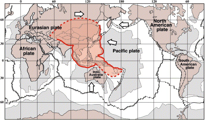
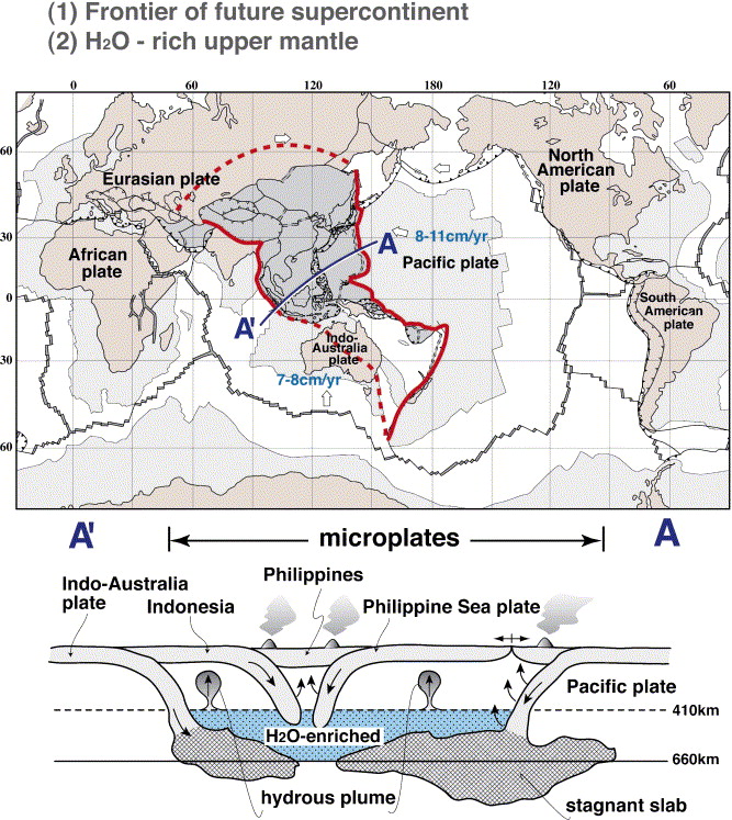
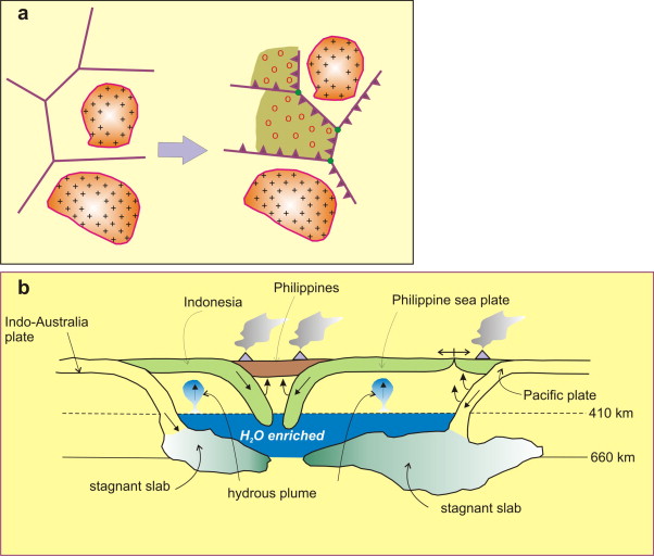
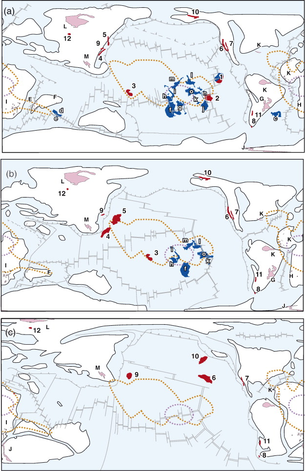
Location of the western Pacific triangular region. East Asia is the location of a double-sided subduction zone, where the old Pacific plate subducts from the east, and the Indo-Australia plate from the south. Due to subduction, and hence refrigeration, the upper and lower mantle here are the coldest mantle regions in the world. This is due to the presence of super-downwelling or a cold superplume (Maruyama, 1994), by double-sided subduction. Nevertheless, the East Asia and its environs are the most active regions on the Earth, indicating that the role of water is several orders of magnitude higher than that of the temperature in terms of lowering viscosity and drop of solidus. Note also the predominant occurrence of microplate in this region. Not only the fragmentation of continents but also the formation of small oceans constitutes the major reason for the dominant occurrence of microplates. The schematic cross-section of WPTZ is shown below to illustrate the stagnant slabs, hydrous MBL, and formation of hydrous plumes at 410 km depth by the breakdown reaction of hydrous wadsleyite enriched in incompatible elements |
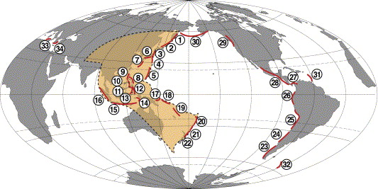
Distribution of island arcs over the world. Geographic names for the individual arcs are after Juteau and Maury (1997), and are numbered. Among 34 arcs over the world, 22 are located in the western Pacific region. |
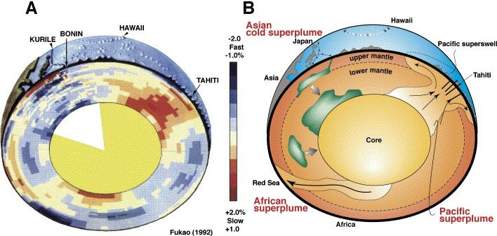
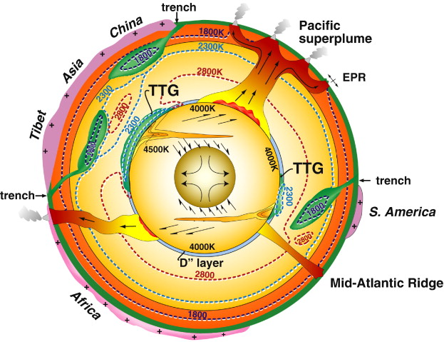
A) P-wave whole mantle tomography of the Earth, showing a profile across Japan and French Polynesia (after Fukao, 1992). (B) P-wave velocity perturbation suggests two large mantle upwellings in the Pacific and Africa, and one super-downwelling in East Asia (Maruyama, 1994). Recent improved tomographic images by S- and P-waves support this classic tomographic image of a superplume. |
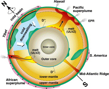
Major convection pattern of the Earth''s mantle showing superplumes and one super-downwelling (modified after Maruyama, 1994). Newly discovered observations are: (1) the presence of a ultralow-velocity zone (ULVZ) right below the superplume, (2) phase transformation of perovskite over post-perovskite at the top of the DЃЌ layer, (3) thickness of the DЃЌ layer is variable, (4) a huge topographic depression in central to east Asia is related to the cold super-downwelling in the mantle, (5) WPTZ corresponds to the region under which the coldest mantle is present, and (6) asymmetric inner core due to either phase change, heterogeneous rheology, or heterogeneous composition-http://www.sciencedirect.com/science/article/pii/S1342937X06002012 |
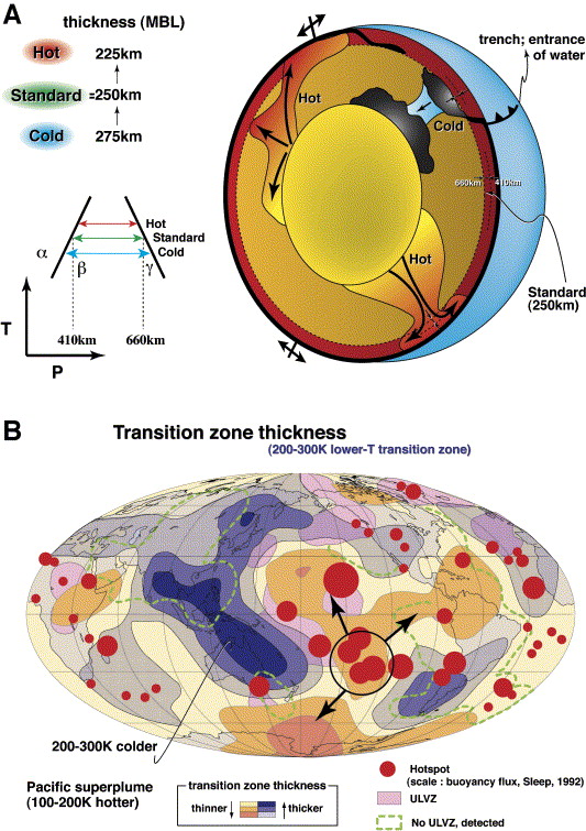
T-distribution of the MBL in the western Pacific (A), as estimated by the thickness of MBL which is defined by a pair of phase changes with negative and positive Clapeyron slopes, olivine over wadsleyite (positive at 410 km), and ringwoodite over perovskite + wЎЎмзАЎзЮЎмзіstite (negative at 660 km). Hence the thickness of MBL is an excellent geothermometer (see inset diagram). (B) Global mapping of the MBL thickness by Flanagan and Shearer (1998) can be transferred to the temperature variation of MBL (Maruyama et al., 2001). Note the WPTZ is the coldest upper mantle 200ЎзЮЎзЮC300 K colder than the averaged standard mantle, whereas Pacific superplume is 100ЎзЮЎзЮC200 K hotter in the central Pacific. This thermal pattern suggests that a rising plume from the lower mantle branches into three in the MBL -http://www.sciencedirect.com/science/article/pii/S1342937X06002012 |
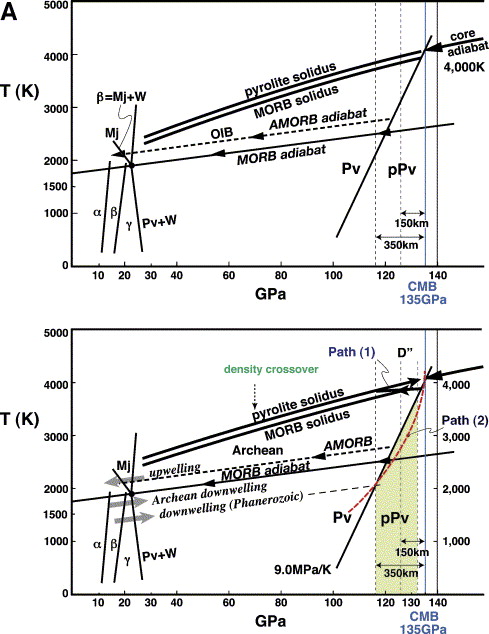
(A) Phase diagram showing the transformation of, (1) olivine = wadsleyite, (2) ringwoodite = perovskite + wЎзЮЎзЮЎЎмзБstite at lower T, (3) ringwoodite = majorite + wЎзЮЎзЮЎЎмзБstite at high-T, and (4) perovskite = post-perovskite in a PЎзЮЎзЮCT space (see Hirose, in press). Two solidus of pyrolite and MORB are shown together (Hirose et al., 1999). Reaction (4) passes at the point of 4000 K 135 GPa (2900 km depth). The Clapeyron slope is calculated as 7.5 MPa/K (Tsuchiya et al., 2004), but we prefer to adopt a value of 9.0 MPa/K; see details in the text. (B) Global mapping of the DЎЎзЮЎмзЧ discontinuity thickness by S-waves (Wysession et al., 1998). Different symbols, circle, triangular and square are for the waveform data by different research groups. Note the thickness variation up to 350 km, and the sharp decrease near the two superplumes, Pacific and Africa, presumably indicating the absence of the DЎЎзЮЎмзЧ layer in those superplume regions. (C) Cross-section along XЎзЮЎзЮCY through Japan in (b), showing a thick DЎЎзЮЎмзЧ layer under WPTZ and sudden decrease in the Pacific superplume. The approximate T is shown in this cross-section -http://www.sciencedirect.com/science/article/pii/S1342937X06002012 |
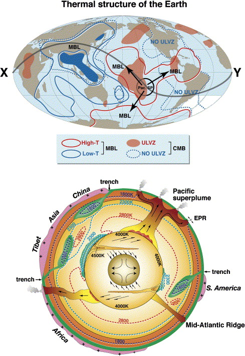
Thermal structure of the Earth. Map-view (top) and cross-section (bottom) (after Maruyama et al., in press). Three data sets: (1) thickness of the MBL, (2) thickness of the DЎЎмзё layer, and (3) global distribution (presence or absence) of the ULVZ ( [26] and [19]), is used to draw these data sets. Converting the observations of (1) and (2) to the phase diagrams mentioned in the text, the thermal structure of the Earth can be drawn along the large circle, including Tibet, China, Japan, French Polynesia to Africa. All data indicate the WPTZ is the coldest mantle from top to bottom, and the superplume regions comprise the hottest mantle in the whole depth range. Topmost core is ca. 4000 K everywhere. Cold spots on the CMB drive downwellings in the outer core. A cold spot under the WPTZ causes downwelling to cool the solid inner core and a preferential growth of the equatorial inner core by precipitation-accumulation of FeЎмЎмCNi crystals, whereas the residual liquids turn less dense, because of enrichment of light elements that rise up to the root of the Pacific superplume. Possible escape of those light elements may drive superplume. Another cold spot derived from the S. American downflow causes similar dynamics against the inner core and the African superplume. Tectonite in the solid inner core may be formed by this general stress field to yield the preferred orientation of metallic Fe-phases. |
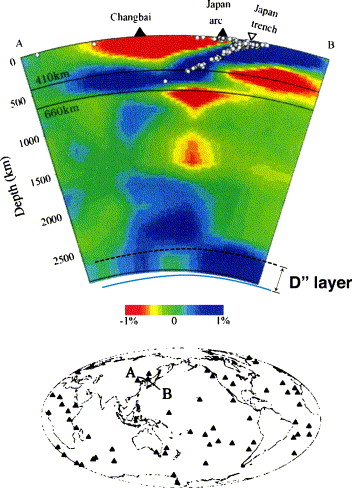
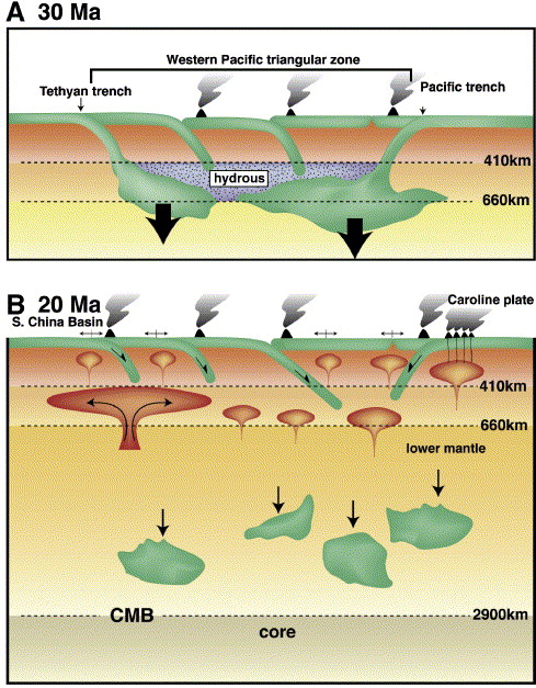
P-wave tomography and the Western Pacific slab graveyards (after Zhao, 2004). The vertical cross-section is shown for a profile passing through northeast China and central Japan. The velocity perturbation scale is shown at the bottom. Note the flat-lying stagnant slabs in the MBL extending over 2000 km. The bimodal distribution of a high-V anomaly along the depth is clear. Low-V anomaly under the Pacific slab in the upper and topmost lower mantle suggests catastrophic collapse of stagnant slabs and mantle replacement from the lower mantle at 30 Ma. |
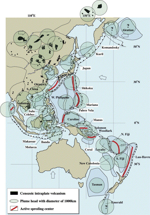
Hot regions in the western Pacific and surrounding regions since the Cretaceous. Most ocean basins and volcanic provinces in East Asia were formed since the Tertiary. More than 36 provinces are identified, as schematically shown by a circle with ca. 1000 km diameter. Note that these hot regions were formed in both East Asia and western Pacific oceanic regions. Fiji basin, Woodlark basin and Caroline ridge cannot be explained by back-arc spreading; instead, a hydrous plume from deeper mantle may explain these. |
A schematic model to show the present bimodal distribution of cold slabs at MBL and right above the CMB by the catastrophic collapse of stagnant slabs at 30 Ma shown in (A) (modified after Maruyama, 1997). The counter flow from the topmost lower mantle triggered by slab flushing may be due to the initiation of large-scale extensive deformation, volcanism, seismicity, mountain-building, and basin formation in the WPTZ which started thereafter (B). |
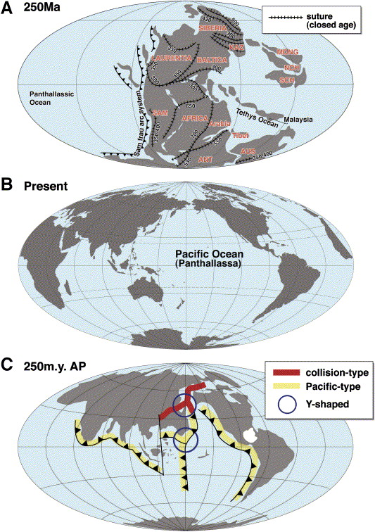
Paleogeography of 250 Ma Pangea (top, after Condie and Sloan, 1997), present-day Earth (middle), and Future Earth at 250 Ma after present (AP) (bottom). Note the center of map (A) is 180ЎзФ different from those of (B) and (C). Note the location of a Y-shaped collision belt between Asia and N. America in (C). To the south of collisional Y-shaped orogen, another Pacific-type Y-shaped zone of orogenic belts may be formed |
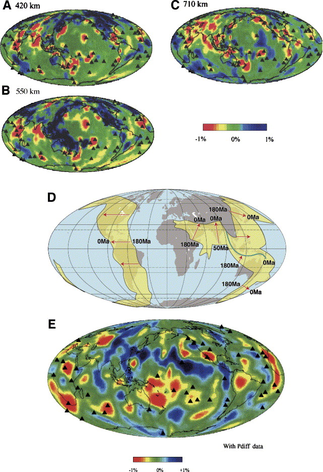
Calculated slab graveyards dating back to 180 Ma (after Lithgow-Bertelloni and Richards, 1998). Calculated trench line migrated inwards towards the Pacific Ocean for ca. 3000 km, whereas in the Tethyan region, the trench line migrated northwards for ca. 3000 km. Through subduction, slab graveyards must have formed, and are now observed as high-V anomalies dominantly in the MBL with subordinate amounts at the CMB. |
P-wave tomographic image of 420 km (A), 550 km (B), 710 km (C), and the base of the mantle (D) at 2750 km (after Zhao, 2004). Note (1) that a high-V anomaly is present predominantly in the circum-Pacific and Tethyan subduction zones in the mantle transition zone, and (2) the calculated slab graveyard during the last 180 Ma (D) matches well the high-V anomaly observed in the MBL. But the high-V anomaly on the CMB (D) does not coincide with the slab graveyard back to 180 Ma, although it overlaps to some extent. The high-V anomalies in the Pacific, India, Antarctica, and Africa, suggest the presence of slab graveyards much older than 180 Ma. |
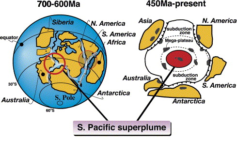
Generalized configuration of Rodinia (after Maruyama, 1994). The locations of Y-shaped orogenic belts and Pacific superplume are also shown. Pacific Ocean was born through the breakup of Rodinia that covered the present-day Pacific Ocean until 750ззC600 Ma. Since the breakup, N. America moved northeastward, AustraliaззCAntarctica moved southward, Siberia and associated blocks in Asia moved northwestward to make an open space under which Pacific superplume was born. The Pacific Ocean enlarged with time until 500ззC450 Ma, then began to decrease in size by subduction, forming circum-Pacific orogenic belts. Episodic activity by the superplume created several huge plateaus which have subducted along the Pacific margin, some remaining as fragments in accretionary complexes (Utsunomia et al., in press). |
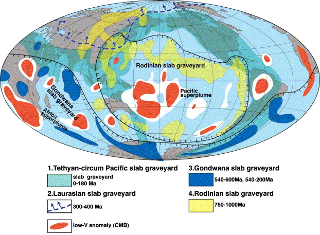
Speculated slab graveyards on the CMB through geological time as estimated by P-wave whole mantle tomography by Zhao (2004). Also shown is the calculated slab graveyard back to 180 Ma, superposed with the present-day distribution of continents. The green region represents slab graveyard during the last 180 Ma, the yellow region shows the Rodinia slab graveyard, and the dark blue region shows the Gondwana slab graveyard. The region with arrows shows the slab graveyard of Laurasia. The definitions of the slab graveyards were based on the paleopositions of the supercontinent or megacontinent. The Pacific superplume is now at the center of the Rodinia slab graveyard. The African superplume is also shown within the Gondwana slab graveyard |
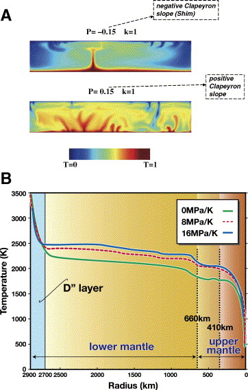
Numerical simulation of mantle convection with or without pPV at the CMB after Nakagawa and Tackley (2004). (A) Mantle convection with endothermic phase transformation at CMB (above) and exothermic phase transformation (below, in the case of PV/pPV). A number of small plumes can be formed, or a single plume is formed. (B) Effects of Clapeyron slope. Compared to the case of no phase transition at CMB (0 MPa/K), PV/pPV (9 MPa/K) increases mantle temperature not only in the lower but also in the upper mantle, ca. 200 K. See more details in Nakagawa and Tackley (2004). |
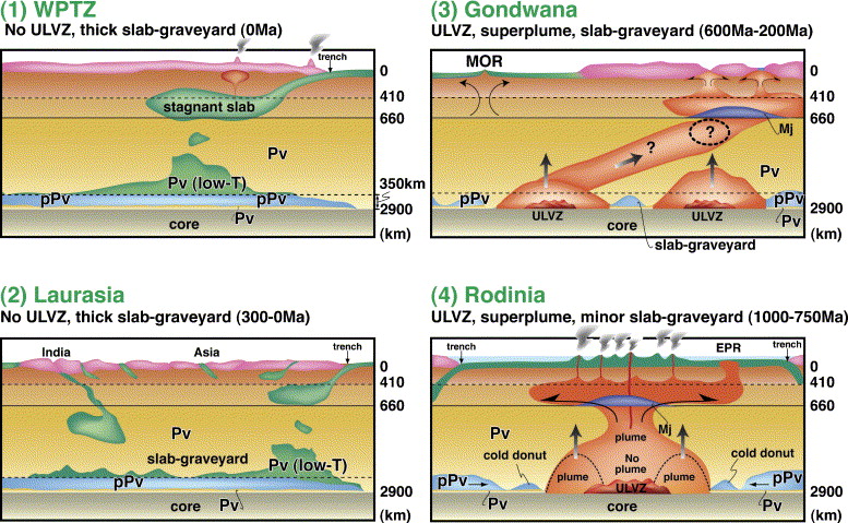
Comparison of the structure of mantle at: (1) the frontier of future supercontinent, WPTZ, (2) Laurasia (central Asia formed at ca. 300 Ma) as a nucleus of the future supercontinent, (3) Gondwana (now evolved to mantle under Africa, India, S. Atlantic and Antarctica), and (4) Rodinia (now evolved in to the Pacific Ocean). Note that the former two are characterized by low-T mantle, whereas the latter two by high-T mantle. Mantle evolves from (1) through (2) and (3) to (4) with time |
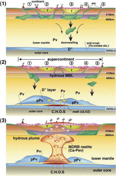
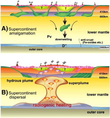
A simplified cartoon showing the mechanism of formation of a superplume at the CMB under the central part of a supercontinent. The presence of post-perovskite is a key to convert the coldest-T to the hottest-T with time. (1) Top figure shows the formation of a supercontinent by successive collisions and amalgamation of continents around a nuclei of continents. By this process, large amounts of subducted slabs are stagnant, and finally collapse to accumulate on the CMB. (2) The selective accumulation of slab under the supercontinent forms a slab graveyard, to make a thick DЎзЦ layer in which post-perovskite appears. The resultant steep geothermal gradient on the CMB promotes a phase change from pPV to PV to reduce the thickness of the DЎзЦ layer. Recycled MORB within the slab graveyard starts to melt to yield a heavy melt and residual andesitic plume. Small plumes begin to rise from the center underneath the supercontinent nucleus. (3) With time, the small plumes form bigger ones by amalgamation due to attraction, and finally a superplume. When the superplume reaches the supercontinent, rifting begins with kimberliteззCcarbonatite explosive magmatism, and is followed by flood basalts. A mechanism to breakup supercontinents through the formation of a superplume by radiogenic heating at CMB. Five continents amalgamate around the nuclei of continents 2 and 3 (stage 1). By successive collision and amalgamation of continents through time during the amalgamation of supercontinents, huge amounts of oceanic slab together with intraoceanic arcs must have subducted underneath and were presumably once stagnant at mantle transition zones, later collapsing to accumulate on the CMB (stage 2). Selective accumulation of TTG crust in the slab graveyard centered underneath the supercontinent causes heating up of the DФ layer through time. Heat anomaly would lead to the rise of the superplume in addition to the heating from the core. Radiogenic heating from the TTG crust on the DФ layer plays a major role for the birth of the superplume which later breaks up the supercontinent.http://www.sciencedirect.com/science/article/pii/S1342937X08001846 |
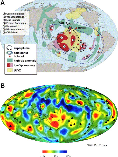
(A) The Pacific superplume is a cluster composed of 4 independent plumes originating from the CMB. Between them are high-V regions, such as (1), (2) and (3), which are high-V regions defined by both S- and P-waves, albeit with different ratios suggesting a compositional difference, to be verified in future studies. (B) Cold donut surrounding the Pacific superplume. Note the large velocity and T gradients along the margins of the Pacific superplume. P-wave velocity perturbation data for the bottom of mantle is from Zhao (2004). |
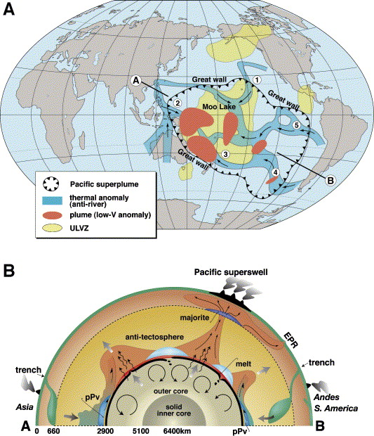
Distribution of thermal anomalies of the DЎе layer after Trampert et al. (2004). (A) Shows the network of these anomalies which might indicate the lateral flow of partial melt, mimicking river drainage systems at the bottom of the mantle. The arrows represent the directions of river flow, according to the expected T distribution. All rivers meet at Moo Lake in the center of the Pacific superplume. A low-V anomaly near the CMB, documented by P-waves, is shown as circles. The numbers, 1, 2, 3, 4 and 5 correspond to the names defined as anti-rivers on the CMB (see text in details). The locations of plumes defined as low-V anomalies (red) are also shown. Note that the site of these rising plumes tend to coincide with the junctions of the anti-rivers as defined in this paper. (B) Shows a cross-section along AЁCB, where convection cells right below the thermal anomaly on the CMB are schematically shown in the outer core |
Schematic EW section across the Pacific superplume showing the generalized petro-chemical structure and dynamics. The old center of the superplume may have lost its recycled MORB component, instead it is enriched in Mg-perovskite as an anti-tectosphere. |
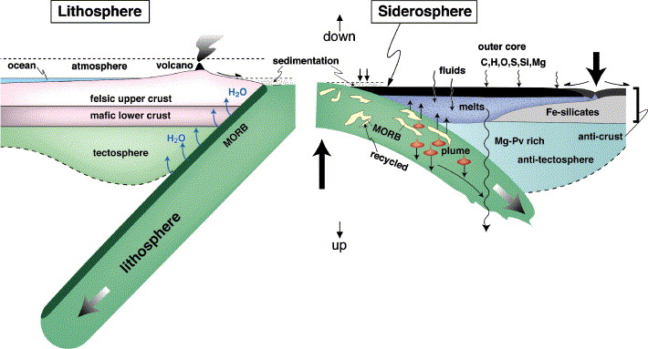
Schematic illustration of anti-plate tectonics on the bottom of the mantle (right). For comparison, the continental crust and its formation process by plate tectonics is shown (left). Note the upside-down nature of the right figure, for illustrating the similarity between the two processes on the top and bottom of the mantle. Also note the similarity of (1) horizontal movements, (2) role of fluids, water vs. light elements in the core, (3) dual compositional layers in the crust, (4) role of MORB crust for chemical fractionation, and (5) sedimentation. |
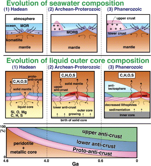
Chemical evolution of seawater and liquid core through geologic time. Top figure: After the birth of a primordial ocean on the Earth, the chemistry of seawater was controlled by waterЦrock interaction from komatiitic crust in the Hadean, through tholeiitic basalt in the Archean to Proterozoic, to a prominent granitic component in the Phanerozoic. Middle figure: In the liquid core of the Earth, chemistry must have been controlled by an increased volume of chemically fractionated anti-crust. Right after its formation, the metallic core must have incorporated large amounts of peridotite components such as Si, Mg and O, in addition to Fe and Ni, because of direct contact at the CMB. With time, an anti-crust developed, the volume of lower metallic crust and upper Fe-silicate-oxide crust increased, separating the core from the mantle. This caused the selective expense of Si, O, and Mg to form the hanging wall of the lower anti-crust, with a depletion of these elements in the core. Bottom figure: Schematic representation of the growth curve of anti-crust through time. The episodic growth of granitic crust on the top of mantle at 2.7 Ga, 2.0 Ga and 1.9Ц0.7 Ga suggests the episodic growth of anti-crust on the CMB. |
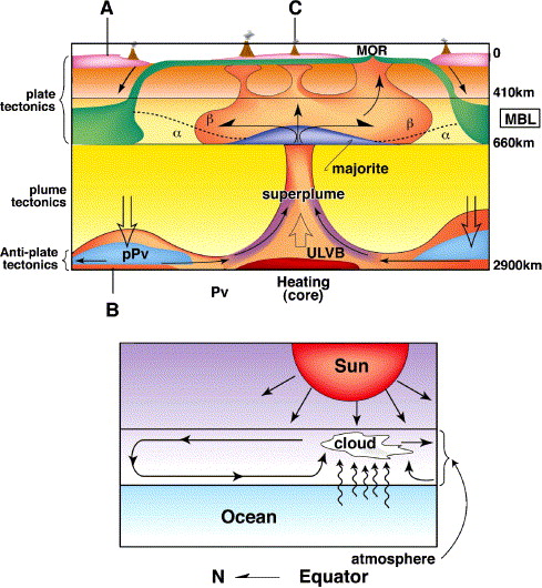
The driving force for mantle dynamics of the solid Earth. Heating from the core generates a superplume to carry the internal heat of the Earth to the surface. Superplume breaks up supercontinents and continents, and anchors mid-oceanic ridge to produce lithospheric plate. Cooling plays a subordinate role to yield slab-pull force to promote subduction to circulate materials from top to the bottom of mantle on a global scale. The bottom figure shows the similar style of convection on the surface of the Earth. Solar energy drives the atmospheric circulation from equatorial to the polar regions. The most essential driving force is derived from heating by the Sun and not by cooling from planetary space. Similarly, heat from the core is the most essential cause of the mantle dynamics. |
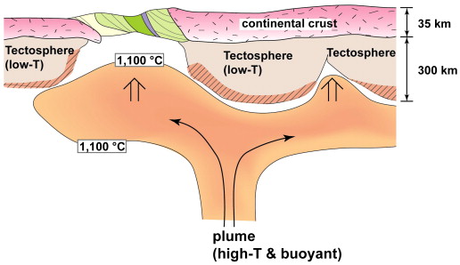
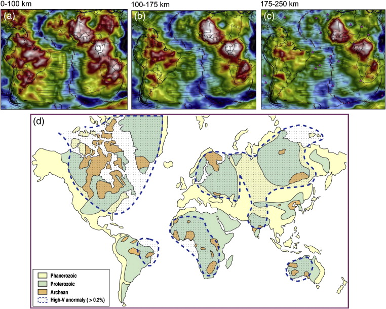
Thermal and material erosions of tectosphere by a rising plume. Tectosphere, characterised by low temperature and chemical buoyancy developed under cratons older than 2.0 Ga. The tectosphere is thermally eroded by high temperature plume material and metasomatically replaced. The volume of tectosphere has been reduced in volume through geologic time by the repeated intrusion of high temperature plumes, dominantly during continental break-up. However, about 10 vol.% of tectosphere still remains in the whole upper mantle of the Earth. Note the size difference of continental crust against tectosphere. Rising plume selectively moves along the boundary of two tectosphere blocks or along tectosphere absent zone. The making and breaking of supercontinents: Some speculations based on superplumes, super downwelling and the role of tectosphere -http://www.sciencedirect.com/science/article/pii/S1342937X08001597 |
Distribution of tectosphere defined by S-wave tomography (Grand, 2002). Note the selective occurrence of high velocity anomaly under cratons older than 2.0 Ga and downward thinning of tectosphere. Maximum depths are about 300 km. The continental crust is only about one tenth of the continental keel.The mechanisms of formation and disruption of supercontinents have been topics of debate. Based on the Y-shaped topology, we identify two major types of subduction zones on the globe: the Circum-Pacific subduction zone and the Tethyan subduction zone. We propose that the process of formation of supercontinents is controlled by super downwelling that develops through double-sided subduction zones as seen in the present day western Pacific, and also as endorsed by both geologic history and P-wave whole mantle tomography. The super-downwelling swallows all material like a black hole in the outer space, pulling together continents into a tight assembly. The fate of supercontinents is dictated by superplumes (super-upwelling) which break apart the continental assemblies. We evaluate the configuration of major supercontinents through Earth history and propose the tectonic framework leading to the future supercontinent Amasia 250 million years from present, with the present day Western Pacific region as its frontier. We propose that the tectosphere which functions as the buoyant keel of continental crust plays a crucial role in the supercontinental cycle, including continental fragmentation, dispersion and amalgamation. The continental crust is generally very thin, only about one tenth of the thickness of the tectosphere. If the rigidity and buoyancy is derived from the tectosphere, with the granitic upper crust playing only a negligible role, then supercontinent cycle may reflect the dispersion and amalgamation of the tectosphere. Therefore, supercontinent cycle may correspond to super-tectosphere cycle.http://www.sciencedirect.com/science/article/pii/S1342937X08001597 |
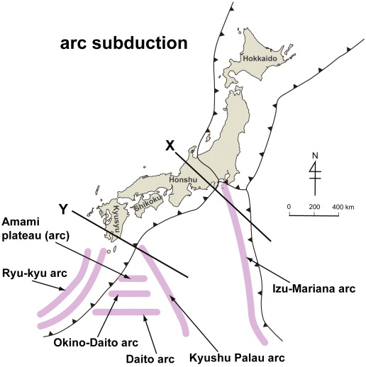
Arc subduction around Japan. IzuЦMariana arc has collided against Honshu since the Middle Miocene resulting in the oroclinal bending of the Shimanto orogenic belt. However, the major part of collided arc must have subducted to deep mantle as suggested by the thickness of continental crust in Honshu, which is about 35 km, similar to the normal thickness of the crust in the rest part of the Honshu arc, without any indication of accretion of Izu continental crust to Honshu, in spite of long lasting collision history for over the last 17 million years. To the southwest of SW Japan, four intra-oceanic arcs are being subducted under the KyushuЦOkinawa arc from the north to the south. The KyushuЦPalau arc (50 to 30 Ma old) is a dead and inactive arc since 30 Ma. The thickness of the IzuЦBonin arc is 20Ц30 km and that of KyushuЦPalau is about 20 km. The next arc is the Amami plateau; Late Cretaceous andesite and granite have been dredged from here. The Daito arc and OkinoЦDaito arc, both Eocene, presumably formed by back-arc spreading by southward subduction of the Shikoku Basin. All of the four arcs are subducting westward without any accretion to the hanging wall of the Eurasian plate. These examples of subducting arcs under the Japanese islands demonstrate that subduction of buoyant small arcs is a common phenomenon -http://www.sciencedirect.com/science/article/pii/S1342937X08001597 |
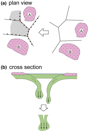
Top figure shows the plan view of the triple junction of consuming plate boundaries. Plate A and plate B contain continents. The remaining three plates are oceanic. Right hand side figure shows the random distribution of consuming plate boundaries, without any definite Y-shaped topology. When Y-shaped topology develops, a strong downwelling is initiated, which grows into stronger and bigger downwelling to develop finally into a super downwelling to swallow all of the continents above. (b) The bottom figure shows a mechanism to grow a super downwelling when several smaller downwellings are present. The bigger one will swallow the smaller ones to promote faster and more rapid downwelling. The making and breaking of supercontinents: Some speculations based on superplumes, super downwelling and the role of tectosphere -http://www.sciencedirect.com/science/article/pii/S1342937X08001597 |
Cartoon illustrating the concept of double-sided subduction discussed in the text (after Santosh et al., 2009a). (b) Double-sided subduction in the Western Pacific region, considered as the frontier of a future supercontinent (after Maruyama et al., 2007). -http://www.sciencedirect.com/science/article/pii/S0301926810000446 Assembling North China Craton within the Columbia supercontinent: The role of double-sided subduction http://plate-tectonic.narod.ru/northchinaphotoalbum.html |
Reconstructed paleogeographic maps at ca. 85 Ma (a), ca. 120 Ma (b) and 165 Ma (c). Distribution map of LIPs, ophiolites and greenstone belts whose tectonic setting is an oceanic plateau worldwide (a) and reconstructed paleogeographic maps at ca. 35 Ma (b) and ca. 65 Ma (c). (a) is after [6] and [57]. The regions enveloped by bold orange and purple dashed lines show the seismic lower velocity zones (Vs) at 2850 m depth in lower mantle and superswell regions, respectively (Courtillot et al., 2003). These express the present superplume roots and active areas. Numbers of ophiolites and greenstone belts listed in Table 1. A = Columbia River basalts; B = Ethiopian and Yemen Traps; C = NAVP; D = Deccan Trap; E = Madagascar basalts; F = Rajmahal basalts; G = Paranб basalts; H = Etendeka basalts; I = Karoo basalts; J = Ferrar basalts; K = CAMP; L = Siberian Trap; M = Emeishan flood basalts. a = Iceland; b = Walvis Ridge; c = Rio Grande plateau; d = Broken Ridge; e = Kerguelen Plateau; f = Ontong Java plateau; g = Nauru Basin; h = East Mariana Basin; I = Pigafetta Basin; j = Manihiki Plateau; k = Magellan Rise; l = Hess Rise; m = Shatsky Rise; n = Line Islands; o = Mid-Pacific Mountains http://www.sciencedirect.com/science/article/pii/S1342937X07002018 |
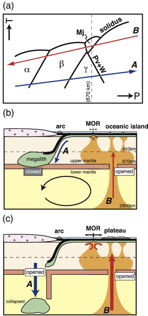
Cartoons showing Cretaceous plate tectonics and a superplume in the Pacific. (a) Schematic phase diagram of mantle peridotite in PЦT space (modified after [95] and [27]) with a subduction zone geotherm A and a plume geotherm B. The plume geotherm passes the majorite/perovskite transition curve with a positive slope, suggesting that mantle upwelling can be accelerated at ca. 670-km depth to transport fertile lower mantle materials to the upper mantle (See also Kumazawa and Maruyama, 1994). (b) Schematic cross-section showing mantle convection and its related volcanism at a normal stage. (c) Schematic cross-section showing whole-mantle convection and the resultant activated volcanism at a pulse stage. A collapsed megalith accelerates a single-layered convection on a whole-mantle scale http://www.sciencedirect.com/science/article/pii/S1342937X07002018 Preserved paleo-oceanic plateaus in accretionary complexes: Implications for the contributions of the Pacific superplume to global environmental change. We have reinvestigated the mid-Cretaceous plume pulse in relation to paleo-oceanic plateaus from accretionary prisms in the circum-Pacific region, and we have correlated the Pacific superplume activity with catastrophic environmental changes since the Neoproterozoic. The Paleo-oceanic plateaus are dated at 75Ц150 Ma; they were generated in the Pacific superplume region and are preserved in accretionary prisms. The volcanic edifice composed of both modern and paleo-oceanic plateaus is up to 10.7 ╫ 10st5 km2 in area and 19.1 ╫ 10st7 km3 in volume. The degassing rate of CO2 (0.82 − 1.1 ╫ 10st18 mol/m.y.) suggests a significant impact on Cretaceous global warming. The synchronous occurrence of paleo-oceanic plateaus in accretionary complexes indicates that Pacific superplume pulse activities roughly coincided at the Permo-Triassic boundary and the VendianЦCambrian boundary interval. The CO2 expelled by the Pacific superplume probably contributed to environmental catastrophes. The initiation of the Pacific superplume contributed to the snowball Earth event near the VendianЦCambrian boundary; this was one of the most dramatic events in Earth''s history. The scale of the Pacific superplume activity roughly corresponds to the scale of drastic environmental change. http://www.sciencedirect.com/science/article/pii/S1342937X07002018 |
Cross section of the Earth showing subducted and accumulated TTG layer above the DФ layer. A major portion of the TTG materials formed on the surface was subducted to the deep mantle. Figure modified after Maruyama et al. (2007a).The tonalite-trondhjemite-granite (TTG) crust has been considered to be buoyant and hence impossible to be subducted into the deep mantle. However, recent studies on the juvenile arc in the western Pacific region indicate that immature island arcs subduct into the deep mantle in most cases, except in the case of parallel arc collision. Moreover, sediment trapped subduction and tectonic erosion are also common. This has important implications in evaluating the role of TTG crust in the deep mantle and probably on the bottom of the mantle. Because the TTG crust is enriched in K, U and Th, ca. 20 times more than that of CI chondrite, the accumulated TTG on the Core Mantle Boundary (CMB) would have played a critical role to initiate plumes or superplumes radiating from the thermal boundary layer, particularly after 2.0 Ga, related to the origin of superplume-supercontinent cycle. This is because selective subduction of oceanic lithosphere including sediment-trapped subduction, tectonic erosion and arc- and microcontinent-subduction proceeded under the supercontinent before the final amalgamation ca. 200-300 million years after the formation of the nuclei. We speculate the mechanism of superplume evolution through the subduction of TTG-crust and propose that this process might have played a dominant role in supercontinent breakup -http://www.sciencedirect.com/science/article/pii/S1342937X08001846 |
Previous models on the mechanism of supercontinent breakup. Top figure: thermal blanket effect of supercontinent cause upwelling immediately below the supercontinent. Bottom figure: phase change of subducted Mid Ocean Ridge Basalt (MORB) into post-perovskite releases latent heat causing many small scale hot plumes, which finally gather to make a superplume -http://www.sciencedirect.com/science/article/pii/S1342937X08001846 |
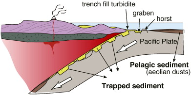
Mechanisms of arc subduction and tectonic erosion. TTG materials are transported by subducting plate as pelagic sediments and/or trapped sediments |
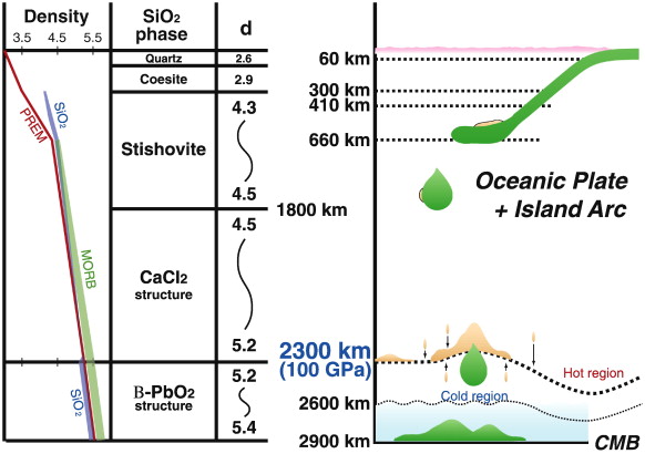
Fate of TTG crust in the whole mantle scale. Subducted TTG is buoyant above the depth corresponding to 70 kb at which quartz (d = 2.65 g/cc) and feldspar (d = 2.55Ц2.76 g/cc) turn to coesite (2.93 g/cc) and hollandite (4.84 g/cc), respectively. At depth of 300 km, coesite turns to stishovite (d = 4.3 g/cc). On the other hand, mantle density is 3.5Ц5.6 through the depth range from surface to the CMB (2900 km). SiO2 polymorphic transformation in P-T space is after Kuwayama et al. (2005). Density change of rock-forming minerals in MORB along the PREM is after Hirose et al. (2005 |
http://plate-tectonic.narod.ru/aziaSEphotoalbum.html
http://www.sciencedirect.com/science/article/pii/S0012825207000542 Cenozoic tectonic and depth/age evolution of the Indonesian gateway and associated back-arc basins
Superplume, supercontinent, and post-perovskite: Mantle dynamics and anti-plate tectonics on the Core–Mantle Boundary
The Western Pacific Triangular Zone (WPTZ) is the frontier of a future supercontinent to be formed at 250 Ma after present. The WPTZ is characterized by double-sided subduction zones to the east and south, and is a region dominated by extensive refrigeration and water supply into the mantle wedge since at least 200 Ma. Long stagnant slabs extending over 1200 km are present in the mid-Mantle Boundary Layer (MBL, 410–660 km) under the WPTZ, whereas on the Core–Mantle Boundary (CMB, 2700–2900 km depth), there is a thick high-V anomaly, presumably representing a slab graveyard. To explain the D″ layer cold anomaly, catastrophic collapse of once stagnant slabs in MBL is necessary, which could have occurred at 30–20 Ma, acting as a trigger to open a series of back-arc basins, hot regions, small ocean basins, and presumably formation of a series of microplates in both ocean and continent. These events were the result of replacement of upper mantle by hotter and more fertile materials from the lower mantle.
The thermal structure of the solid Earth was estimated by the phase diagrams of Mid Oceanic Ridge Basalt (MORB) and pyrolite combined with seismic discontinuity planes at 410–660 km, thickness of the D″ layers, and distribution of the ultra-low velocity zone (ULVZ). The result clearly shows the presence of two major superplumes and one downwelling. Thermal structure of the Earth seems to be controlled by the subduction history back to 180 Ma, except in the D″ layer. The thermal structure of the D″ layer seems to be controlled by older slab-graveyards, as expected by paleogeographic reconstructions for Laurasia, Gondwana and Rodinia back to 700 Ma.
Comparison of mantle tomography between the Pacific superplume and underneath the WPTZ suggests the transformation of a cold slab graveyard to a large-scale mantle upwelling with time. The Pacific superplume was born from the coldest CMB underneath the 1.0–0.75 Ga supercontinent Rodinia where huge amounts of cold slabs had accumulated through collision-amalgamation of more than 12 continents. A high velocity P-wave anomaly on a whole-mantle scale shows stagnant slabs restricted to the MBL of circum-Pacific and Tethyan regions. The high velocity zones can be clearly identified within the Pacific domain, suggesting the presence of slab graveyards formed at geological periods much older than the breakup of Rodinia. We speculate that the predominant subduction occurred through the formation period of Gondwana, presumably very active during 600 to 540 Ma period, and again from 400 to 300 Ma during the formation of the northern half of Pangea (Laurasia). We correlate the three dominant slab graveyards with three major orogenies in earth history, with the emerging picture suggesting that the present-day Pacific superplume is located at the center of the Rodinian slab graveyard.
We speculate the mechanism of superplume formation through a comparison of the thermal structure of the mantle combined with seismic tomography under the Western Pacific Triangular Zone (WPTZ), Laurasia (Asia), Gondwana (Africa), and Rodinia (Pacific). The coldest mantle formed by extensive subduction to generate a supercontinent, changes with time of the order of several hundreds of million years to the hottest mantle underneath the supercontinent. The Pacific superplume is tightly defined by a steep velocity gradient on the margin, particularly well documented by S-wave velocity. The outermost region of the superplume is characterized by the Rodinia slab graveyard forming a donut-shape. We develop a petrologic model for the Pacific superplume and show how larger plumes are generated at shallower depths in the mantle. We link the mechanism of formation of the superplume to the presence of the mineral post-perovskite, the phase transformation of which to perovskite is exothermic, and thus aids in transporting core heat to mantle, and finally to planetary space by plumes.
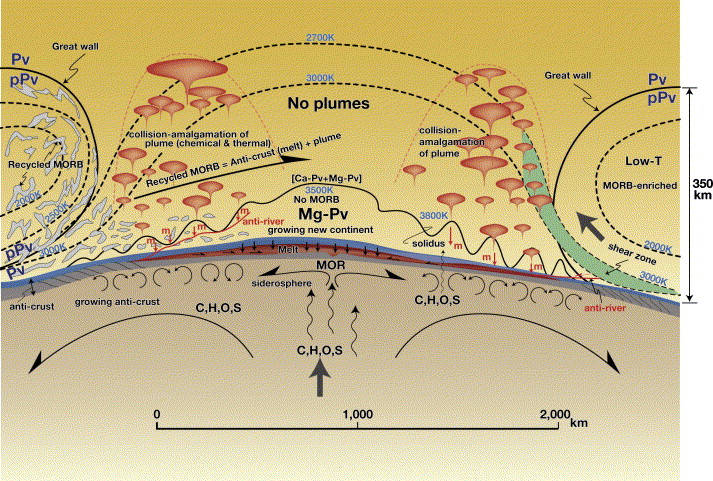
We summarize the characteristics of tectonic processes operating at the CMB to propose the existence of an Ѓganti-crustЃh generated through Ѓganti-plate tectonicsЃh at the bottom of the mantle. The chemistry of the anti-crust markedly contrasts with that of the continental crust overlying the mantle. Both the crust and the anti-crust must have increased in volume through geologic time, in close relation with the geochemical reservoirs of the Earth. The process of formation of a new superplume closely accompanies the process of development of anti-crust at the bottom of mantle, through the production of dense melt from the partial melting of recycled MORB, observed now as the ULVZ. When CMB temperature is recovered to near 4000 K through phase transformation, the recycled MORB is partially melted imparting chemical buoyancy of the andesitic residual solid which rises up from CMB, leaving behind the dense melt to sink to CMB and thus increase the mass of anti-crust. These small-scale plumes develop to a large-scale superplume through collision and amalgamation with time. When all recycled MORBs are consumed, it is the time of demise of superplume. Immediately above the CMB, anti-plate tectonics operates to develop anti-crust through the horizontal movement of accumulated slab and their partial melting. Thus, we speculate that another continent, or even a supercontinent, has developed through geologic time at the bottom of the mantle.
We also evaluate the heating vs. cooling models in relation to mantle dynamics. Rising plumes control not only the rifting of supercontinents and continents, but also the Atlantic stage as seen by anchored ridge by hotspots in the last 200 Ma in the Atlantic. Therefore, we propose that the major driving force for the mantle dynamics is the heat supplied from the high-T core, and not the slab pull force by cooling. The best analogy for this is the atmospheric circulation driven by the energy from Sun
Keywords Superplume; Post-perovskite; Supercontinent; Anti-plate tectonics; Anti-crust - http://www.sciencedirect.com/science/article/pii/S1342937X06002012
Location of the western Pacific triangular region. East Asia is the location of a double-sided subduction zone, where the old Pacific plate subducts from the east, and the Indo-Australia plate from the south. Due to subduction, and hence refrigeration, the upper and lower mantle here are the coldest mantle regions in the world. This is due to the presence of super-downwelling or a cold superplume (Maruyama, 1994), by double-sided subduction. Nevertheless, the East Asia and its environs are the most active regions on the Earth, indicating that the role of water is several orders of magnitude higher than that of the temperature in terms of lowering viscosity and drop of solidus. Note also the predominant occurrence of microplate in this region. Not only the fragmentation of continents but also the formation of small oceans constitutes the major reason for the dominant occurrence of microplates. The schematic cross-section of WPTZ is shown below to illustrate the stagnant slabs, hydrous MBL, and formation of hydrous plumes at 410 km depth by the breakdown reaction of hydrous wadsleyite enriched in incompatible elements.
Mantle dynamics of Western Pacific and East Asia: Insight from seismic tomography and mineral physics
• Recent results of high-resolution seismic tomography and mineral physics experiments are used to study mantle dynamics of Western Pacific and East Asia. The most important processes in subduction zones are the shallow and deep slab dehydration and the convective circulation (corner flow) processes in the mantle wedge. The combination of the two processes may have caused the back-arc spreading in the Lau basin, affected the morphology of the subducting Philippine Sea slab and its seismicity under southwest Japan, and contributed to the formation of the continental rift system and intraplate volcanism in Northeast Asia, which are clearly visible in our tomographic images. Slow anomalies are also found in the mantle under the subducting Pacific slab, which may represent (a) small mantle plumes, (b) upwellings associated with the slab collapsing down to the lower mantle, or (c) sub-slab dehydration associated with deep earthquakes caused by the reactivation of large faults preserved in the slab. Combining tomographic images and earthquake hypocenters with phase diagrams in the systems of peridotite + water, we proposed a petrologic model for arc volcanism. Arc magmas are caused by the dehydration reactions of hydrated slab peridotite that supply water-rich fluids to the mantle wedge and cause partial melting of the convecting mantle wedge. A large amount of fluids can be released from hydrated MORB at depths shallower than 55 km, which move upwards to hydrate the wedge corner under the fore-arc, and never drag down to the deeper mantle along the slab surface. Slab dehydration reactions at 120 km depth are the antigorite-related 5 reactions which supply water-rich fluids for forming the volcanic front. Phase A and Mg-surssasite breakdown reactions at 200 and 300 km depths below 700 Ѓ‹C cause the second and third arcs, respectively. Moreover, the dehydration reactions of super-hydrous phase B, phases D and E at 500–660 km depths cause the fluid transportation to the mantle boundary layer (MBL) (410–660 km depth). The stagnant slabs extend from Japan to Beijing, China for over 1000 km long, indicating that the arc–trench system covers the entire region from the Japan trench to East Asia. We propose a big mantle wedge (BMW) model herein, where hydrous plumes originating from 410 km depth cause a series of intra-continental hot regions. Fluids derived from MBL accumulated by the double-sided subduction zones, rather than the India–Asia collision and the subsequent indentation into Asia, are the major cause for the active tectonics and mantle dynamics in this broad region Keywords: Seismic tomography; Dehydration; Water in the mantle; Western Pacific; Volcanism; Intraplate tectonics - http://www.sciencedirect.com/science/article/pii/S1342937X06001912
Preserved paleo-oceanic plateaus in accretionary complexes: Implications for the contributions of the Pacific superplume to global environmental change http://www.sciencedirect.com/science/article/pii/S1342937X07002018
The making and breaking of supercontinents: Some speculations based on superplumes, super downwelling and the role of tectosphere -http://www.sciencedirect.com/science/article/pii/S1342937X08001597
Role of tonalite-trodhjemite-granite (TTG) crust subduction on the mechanism of supercontinent breakuphttp://www.sciencedirect.com/science/article/pii/S1342937X08001846
3D structure of the Earth''s lower mantle
Structure tridimensionnelle du manteau infйrieur de la Terrehttp://www.sciencedirect.com/science/article/pii/S1631071303000129
Supercontinent tectonics
Seismology Fundamentals
Books
Kюыхсрэш ёшёЄхь√ фЁю-ьрэЄш
MANTLE PETROLOGY IN RELATION TO PLATE TECTONICS