 | San Andreas fault |
|
|
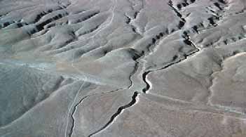
Right-lateral displacement on the San Andreas fault is illustrated by the offset of Wallace Creek in the Carrizo Plain of the southern Coast Ranges |
|
C http://www.grossmont.edu/garyjacobson/Naural%20History%20150/Geology%20of%20Southern%20California.pdf
The San Andreas fault is a major geologic feature of North America. Actually, the term San Andreas fault is a misnomer, suggesting that the fault is a single break. It is more accurately called the San Andreas fault system, or zone, with several major and numerous minor branches, particularly in southern California.
The San Andreas Fault
Despite its benign name (Saint Andrew), the San Andreas fault is a violent and destructive killer. Over its long history, spasms of its enormous energy have been released in countless earthquakes along its great length. These have ranged in magnitude from slight tremors to cataclysmic upheavals and rupturing of Earth''s surface.
It is a well known and familiar geologic feature in western America. The remarkably straight fault trace is prominent on any California map. It looks like a knife slash from hell in a northwest-southeast direction that attempts to separate the Coast Ranges from central and southern California.
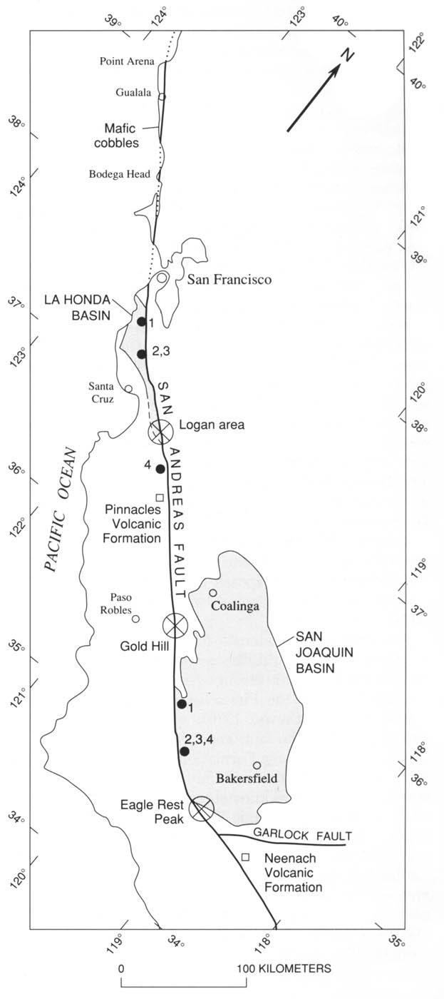
The fault ranks among the longest such structures in the world. Overland, it is a visible break that can be traced for 625 miles from Point Arena, north of San Francisco, to the Salton Sea, near the border with Mexico.
The inferred extensions of the fault are even more dramatic. Northward, the break is thought to extend under the sea another 400 miles, possibly merging into the Murray Fracture Zone on the deep sea floor. At the southern end, the fault is believed to follow the axis of the Gulf of California for almost 1,000 miles.
Because of the fault''s great length, as much as 2,000 miles, movement is intermittent as to time, and random as to place. At any place along the fault, movement may be a one-time event, or movement may be recurrent over thousands of years. In any one episode, displacement may be a fraction of an inch or it may be many feet.
The surface trace of the fault first appears at Point Arena, a peninsula north of San Francisco. It takes a straight path southeastward through a series of elongated valleys to San Francisco Bay, it crosses the bay with San Francisco on the western block and the bay cities on the eastern or continental block.
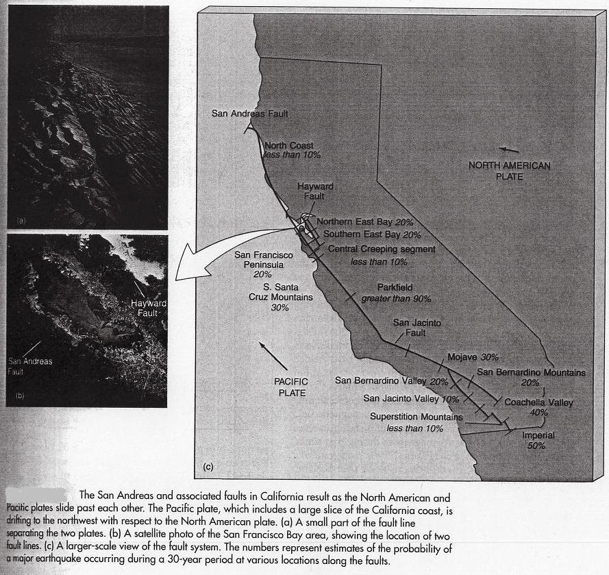
In the San Francisco Bay area, the San Andreas has two major companion branches. Generally defining the east side of the Bay is the Hayward fault, and a few miles inland is the Calaveras fault. The Hayward fault presently carries a high probability forecast for an earthquake.
In an undeviating course, the trace passes San Jose and enters the Coast Ranges. It runs parallel to the Gabilan Range, passes the towns of Coalinga and Parkfield (both with vivid earthquake histories), thence it defines the elongated Temblor Range to Tejon Pass.
This segment of the fault in central California is very old. Between the Bay area and the Tehachapi Mountains, rock formations appear to have been displaced as much as 160 miles. This suggests that the northern section of the fault may have originated about 30 to 40 million years ago, during Oligocene time.
The fault planes of the faults in the system are usually near vertical. In some sections, however, the fault plane is locally tilted as much as 60 degrees to the northeast. A local example of this effect is the Banning fault near Cabazon in San Gorgonio Pass. Here, the fault tilted to the point where the moving western block slid under the eastern block, a thrust fault.
The San Andreas fault is a shallow fault, generally extending into the earth''s crust four to ten miles. Earthquakes associated with shallow faults are more destructive at the surface than those originating from deep-seated faults.
The San Andreas is an uninterrupted zone of many braided fault traces. These fractures branch and interlace in a swath two to eight miles wide along the fault''s great length. With these multiple fractures creating great slices or slabs, and over countless episodes of earth movement, the rocks within the fault zone have been severely deformed, smashed and ground up. Thus weakened and broken, they become subject to rapid weathering and erosion.
So, the fault course in central California has been eroded into a series of elongated valleys for more than one hundred miles through the Coast Ranges as a shallow trench only a few miles wide. This distinctive landform was made both from erosion of the shattered and weathered rocks and from the effect of recent faulting. The valleys contain many typical fault-related features such as offset streams, ponds, and scarps. This string of continuous valleys is recognizable on any large scale road map.
In southern California, the fault is much younger. Major right-lateral movement began about 12 million years ago, or during late Miocene time.
This considerably predates the opening of the present Gulf of California which began about 5.5 million years ago. The progressively younger age of segments of the fault from north to south is consistent with ideas concerning plate movement along the west coast of North America.
The southern California segment of the San Andreas fault is described from the vicinity of Gorman, about 60 miles northwest of Los Angeles. There, it bends abruptly to the east for six miles, then resumes its original southeast heading.
This "Big Bend" area is possibly the most significant tectonic area in California today. Here, the San Andreas intersects the left-lateral Garlock fault, the only major east-west trending fault in southern California. Earthquakes are common in this area. The Fort Tejon earthquake in 1857 (magnitude 8-plus) is thought to have been at least as violent as the San Francisco earthquake 49 years later. The San Fernando earthquake of 1971 (magnitude 6.6) was also associated with this zone of intersection.
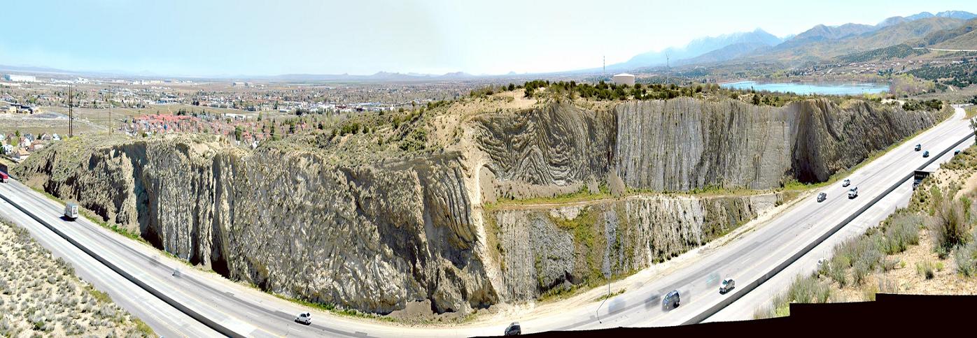
From Tejon Pass, the main trace of the San Andreas fault passes through the high desert north of Los Angeles, defining the north face of the San Gabriel Mountains. It then separates the San Gabriel Mountains from the San Bernardino Mountains, creating Cajon Pass that takes Interstate 15 out of southern California.
From the vicinity of Cajon Pass, the southern California segment of the San Andreas fault becomes very complex with no distinctive single trace as in the north. Instead, it is divided into several right-lateral elements, all somewhat parallel to each other. Principal among these are the San Jacinto and Elsinore faults. Several branches go through the San Bernardino Mountains and along the north margin of San Gorgonio Pass into the Coachella Valley.
One important associated fault is the San Gabriel fault, defining the southern edge of the San Gabriel Mountains in the Los Angeles basin. This fault was probably the most active strand for thousands of years, but there is no evidence of recent activity. Another important branch in the Los Angeles area is the Newport-Inglewood fault, the source of the destructive Long Beach earthquake of 1923.
The Banning Fault
The Banning fault, a subordinate branch of the San Andreas, first appears east of Riverside, trending almost due east. It defines the north side of San Gorgonio Pass where a section is unique in being a thrust fault. This thrust is responsible for the low, brown-colored hills along the north side of Interstate 10 between Cabazon and Whitewater Canyon.
The fault has created a distinctive gash behind these hills. In crossing Whitewater Canyon, it forms a barrier to the passage of groundwater down-canyon, supporting lush riparian growth in the floor of the canyon.
The Banning fault enters the Coachella Valley near Whitewater, crossing Route 62 about 1.5 miles north of the interchange with Interstate 10. It intersects Indian Avenue one mile north of the freeway, and crosses Palm Drive at 20th Avenue, then continues to the southwest past Palm Springs.
The surface trace of the San Andreas fault is conspicuous on the valley floor by the lineup of vegetation along its north side, a result of fault-dammed groundwater flow. This prominent feature is conpicuous as viewed from the observation post at the top of the aerial tramway.
The Banning fault trace defines the southern margin of the Indio Hills, and supports several beautiful palm oases in the canyons where ground water reaches the surface as seepage along the fault trace. Similarly, the northern margin of the Indio Hills is defined by the Mission Creek fault, and here, too, may be found palm oases, principally Thousand Palms Oasis.
While the Banning fault is very well defined by surface features, its relationship to the main San Andreas fault has not been firmly established. The area in question is the complex fault geology of San Gorgonio Pass.
The Mission Creek Fault
About six miles north of the Banning fault, another branch, the Mission Creek fault, enters the Coachella Valley near the mouth of Morongo Valley. The Mission Creek fault passes directly through the town of Desert Hot Springs, and is responsible for the many warm springs in that area. It intersects Dillon Road near Wide Canyon Road, and marks the northern margin of the Indio Hills. Thousand Palms Oasis is on this fault.
Locally, the Mission Creek fault is the most active branch in the system. Seismological data relating to recent earthquakes and measures from precise triangulation surveys show current persistent movement. Disrupted alluvial deposits, truncated older alluvial fans, and vegetation lines are evidence of its trace. In particular, low scarps may be seen where Indian Avenue meets Route 62, and again at Miracle Hill, east of Desert Hot Springs.
The Banning fault and the Mission Creek fault join at Biskra Palms in the Indio Hills near the north end of Madison Street).
The San Andreas fault continues along the northwest shore of Salton Sea. At Salt Creek Wash, the surface trace of the great fault ends, more than 600 miles from its northern end.
Current thinking is that the San Andreas fault, buried under alluvium, merges with the Imperial fault. It then continues southeastward to the Gulf of California, defining the western margin of the Gulf, finally merging into the East Pacific Rise.
The South Pass Fault
The inferred South Pass fault defines the southern margin of San Gorgonio Pass along the edge of the San Jacinto mountains. The fault has no surface trace, being deeply buried in alluvium. The principal rationale for placing a fault here is (1) the uniform straight mountain scarp, and (2) without a fault, it would be difficult to account for the pass structure. Where the fault enters the Coachella Valley, it curves to the southwest, past Windy Point to about Chino Canyon.
The San Jacinto Fault
The most seismically active fault in southern California today is the San Jacinto fault and its branches. It is also the fault that is potentially troublesome to the Salton Trough. Many earthquakes within historic time have been associated with it.
The San Jacinto fault is a major element of the San Andreas system. Separating from the San Andreas west of Cajon Pass, it takes a more southerly but generally parallel track. The trace bisects the city of San Bernardino, and passes directly under the four-level freeway interchange at Colton. Its path takes it behind the San Jacinto Mountains, passing the communities of San Jacinto and Hemet. Along the mountain front in this area, the fault has dammed groundwater channels, forcing water to the surface as hot springs.
It lies west and south of the San Jacinto Mountains, and for several miles forms the northeast edge of Borrego Valley. The fault cuts the Ocotillo Badlands near Ocotillo Wells, then enters the Imperial Valley where its trace is buried under recent lake bed sediments. The known length of the fault is approximately 180 miles.
Like the San Andreas, it is a complex system of many faults with local names. At its northwest end, following its separation from the San Andreas fault near San Bernardino, it generally has one or more well-defined breaks, especially where its trace cuts across rocks of somewhat recent age. Southeastward, it includes several zones of subparallel breaks, separating masses of bed rock into slabs ranging in width from a few feet to thousands of feet. Although they are parts of the San Jacinto fault zone, many of these subsidiary faults are themselves major features and commonly are given individual names. One important subordinate fault is the Thomas Mountain fault that forms the southwest margin of Garner Valley.
This pattern of multiple faults continues to broaden to the southeast where the San Jacinto zone enters the Salton Trough. There, at least six subordinate faults are spaced half a mile to three miles apart. This pattern continues through the Imperial Valley and into Baja California.
The major breaks in the San Jacinto fault zone dip very steeply to nearly vertical, and the entire zone appears to be a very deep-rooted feature.
There is abundant evidence of recency of movement along most of the length of the fault. In its central section, along the San Jacinto Mountains and the Santa Rosa Mountains, there are many fault scarps, elongate trenches, sag ponds, aligned canyons, and offset drainage. Many earthquakes, moderate to severe in scale, have been recorded from the City of San Jacinto south into Mexico.
The most active branch at this time is the Imperial fault, the source of many tremors and quakes in recent years, some of them very destructive. Another active branch is the Superstition Hills fault along the west side of the Imperial Valley. The very active Cerro Prieto fault on the Mexican side of the border is a member of the San Jacinto system, and is probably an extension of the Imperial fault.
The San Jacinto fault is a young, right lateral zone of seismic strain that has dominated fault movement in southern California for a least a century. Notwithstanding the notoriety of the San Andreas fault, since 1857 there have been 36 major earthquakes identified to faults in the San Jacinto system. Of these, 15 have originated along the Imperial fault in the Salton Trough.
Between 1915 and 1954, five historic large quakes, all with magnitudes between 6.0 to 6.8 on the Richter scale, occurred along this fault between the City of San Jacinto and the Salton Sea.
While presently more active than the San Andreas fault, the San Jacinto fault is much younger in age, having slipped laterally only about 15 miles, compared to nearly 200 miles of displacement along the San Andreas fault. The age of the San Jacinto fault is uncertain, but it seems probable that the fault has been active since at least early Tertiary time.
The Elsinore Fault
A brief mention of the Elsinore Fault is made here only because it is one arm of a trilateral split of the San Andreas Fault. As a geographic feature it is not associated with the Salton Valley.
The third major fault in the southland is the Elsi


