 | San Gabriel Mnts |
LA Basin and San Gabriel mnts |
http://geomaps.wr.usgs.gov/archive/socal/geology/transverse_ranges/san_gabriel_mtns/index.html |
La Basin and San Gabriel mnts |
|
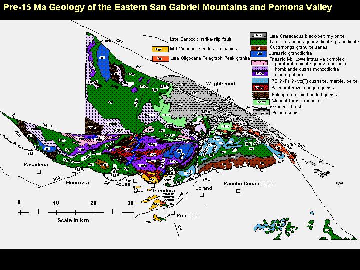
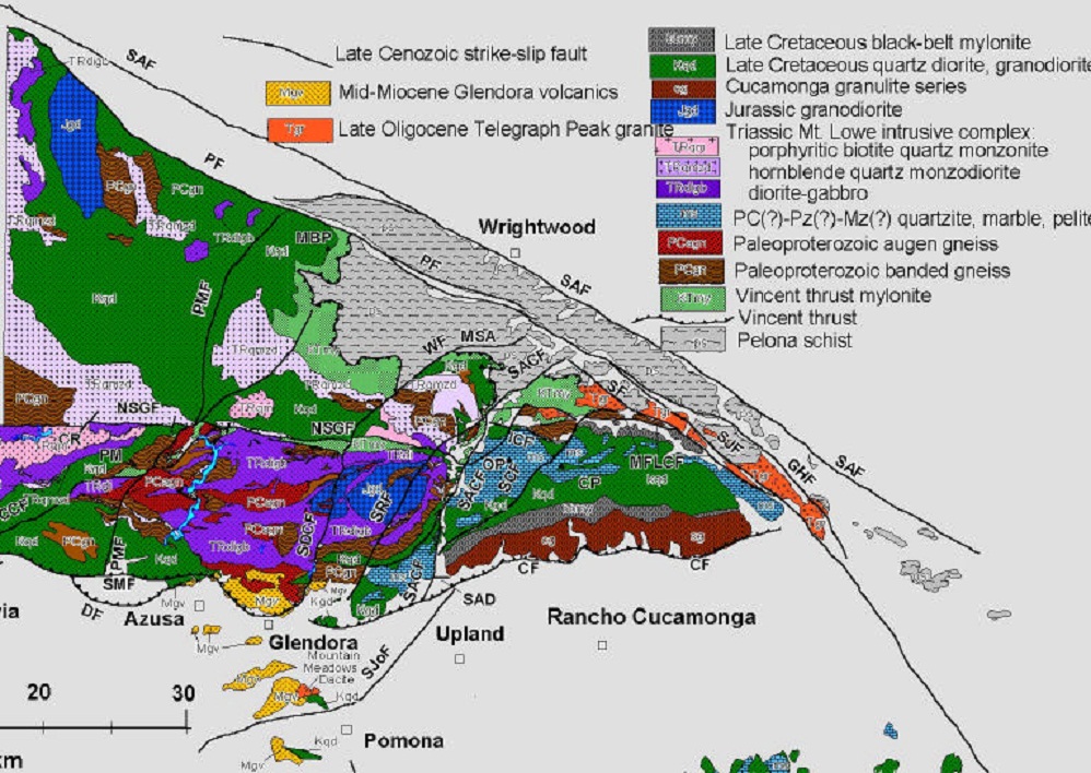
Geologic Maps of the central and eastern San Gabriel Mountains. Reproduced from Figure 3A in Nourse (2002a). Major fault abbreviations are as follows:CF-Cucamonga fault, DF-Duarte fault, GHF-Glen Helen fault, ICF-Icehouse Canyon fault, LF-Lytle Creek Fault, MFLCF-Middle Fork Lytle Creek fault, NSGF-north branch San Gabriel fault, PMF-Pine Mountain fault, PF-Punchbowl fault, RHF-Raymond Hill fault, SCCF-Sawpit Canyon-Clamshell fault, SAF-San Andreas fault,SACF-San Antonio Canyon fault, SCF-Stoddard Canyon fault, SDCF-San Dimas Canyon fault, SF-Scotland fault, SJF-San Jacinto fault, VCF-Vasquez fault, VFVerdugo fault, WF Weber fault - http://geology.csupomona.edu/janourse/StudentTheses/WilkinsThesisFinal.pdf |
Metamorphic Foliations. Outcrop-scale folding of greyschist in the upper North Fork Lytle Creek study area |
Taking a well-earned break on the north side of Lytle Creek''s Middle Fork http://geology.csupomona.edu/janourse/StudentTheses/WilkinsThesisFinal.pdf |
Mt. San Antonio to the northwest as seen from the top of Cucamonga Peak -http://geology.csupomona.edu/janourse/StudentTheses/WilkinsThesisFinal.pdf |
A view of Sugarloaf peak and San Antonio Canyon to the WSW behind Miguel, as seen from the top of Telegraph peak |
A view from the north side of Lytle Creek''s Middle Fork to the southwest between Cucamonga Peak (left) and Bighorn Peak (right). The valley coincides with the trace of the left-lateral Stoddard Canyon fault. |
Fault contact viewed to the east in Lytle Creek''s Middle Fork between nearly white Telegraph Peak Granite (Tgr) on the left and mylonitic leucogranite (mlgr) on the right. |
Outcrop of Pelona Schist and Vincent thrust at San Antonio Falls. White layers are sills of Rhyolite originating from the Telegraph Peak granite |
Almost white Telegraph Peak granite (Tgr) intruding banded Cretaceous mylonite (KTmy). |
Faulted mafic dikes in Telegraph Peak granite (Tgr), showing left-lateral offset and accompanying drag. This fault is one splay of the northern Stoddard Canyon fault. |
Undulation of mafic dike in Telegraph Peak granite near north end of Stoddard Canyon fault zone. |
Foliation of Tgr, characterized by elongated quartz and white plagioclase |
Lineation of Tgr north of Middle Fork Lytle Creek. |
Fault with 2 meter wide crush zone trending N70W in canyon bottom, seen as thin line next to Dr. Nourse.Fault strikes roughly parallel to local foliation in Cretaceous mylonite (KTmy). |
A view south from Blue Ridge looking at the Vincent Thrust on the north face of Mt. Baden Powell. The thrust is the light-dark boundary about half-way up the face of the peak. White sills of Oligocene rhyolite are just below the light-dark boundary about half-way up the face of the peak. White sills of Oligocene rhyolite are just below the thrust. |
Outcrop of Mylonitic tonalite or granodiorite (foliated green unit) interlayered with mylonitic leucogranite |
Sheared dikes of mylonitic leucogranite (mlgr) in mylonitic granodiorite (mgd) from the Middle Fork area |
Photograph of metasedimentary schist like Pelona Schist that occurs in the lower plate of the Vincent Thrust in the southeastern San Gabriel Mountains. This example from the Mt. Rushmore area shows schist interlayered with a granitic dike (image source: University of British Columbia Keck Geology Consortium Structural Geology Slide Set, photograph � Julie Maxson). Vincent Thrust |
View an outcrop closeup of gneissose rock like that occurring in the upper plate of the Vincent Thrust in the southeastern San Gabriel Mountains; these rocks probably originally were plutonic granitic rocks before they were deformed and metamorphosed. This example from the Coast Plutonic complex of British Columbia probably has a geologic history similar to that of upper-plate rocks in the southeastern San Gabriel Mountains (image source: University of British Columbia, photograph � M.L. Bevier) |
View an outcrop closeup of mylonitic (ductiley sheared) rock similar to that occurring in the upper plate of the Vincent Thrust in the southeastern San Gabriel Mountains; these rocks probably originally were plutonic granitic rocks before they were deformed and metamorphosed. This example from southeastern British Columbia probably has a geologic history similar to that of upper-plate rocks in the southeastern San Gabriel Mountains (image source: University of British Columbia, photograph � C.A. Giovanella) |
http://geology.csupomona.edu/janourse/StudentTheses/WilkinsThesisFinal.pdf |
Colored geologic map of the eastern San Gabriel Mountains. Map shows approximately the same area as covered by the thesis map. Modified from Bortugno and Spittler (1986). Notice unresolved issues with several faults including the San Antonio Canyon, Stoddard Canyon, and San Jacinto faults http://geology.csupomona.edu/janourse/StudentTheses/WilkinsThesisFinal.pdf |
Northern section of my thesis map showing major faults and approximate boundaries of primary focus for the upper North Fork Lytle Creek study area.Portions of this plate and succeeding plates include compilation of some unpublished mapping and structural data from Nourse and students (1990-2002 |
Southern section of my thesis map showing major faults and approximate boundaries of primary focus for the Middle Fork Lytle Creek study area. Also note the location of Brent Norum�s Thesis area, an important consideration |
Detail of the Middle Fork Lytle Creek study area from the thesis map. |
Detail of upper North Fork Lytle Creek study area from the thesis map |
Late Miocene San Gabriel Fault and associated east-west striking dextral faults.Intersection between the Icehouse Canyon fault, Stoddard Canyon fault, and Middle Fork Lytle Creek fault, with associated sub-parallel faults through Telegraph Wash |
Detail of the intersection between the Stoddard Canyon fault and the Middle Fork Lytle Creek fault. Notice the four main strands of the Stoddard Canyon fault on the north side of the Middle Fork fault, and the north steps in the Middle Fork (see plates 2 and 6 for larger views of the Middle Fork Lytle Creek area). |
Detail of the eastern portion of the Middle Fork Lytle Creek study area showing several splays of the Stoddard Canyon fault and an interrupted Middle Fork Lytle Creek fault |
Detail of the San Antonio Canyon fault truncating the Quaternary Scotland and Punchbowl faults. The San Jacinto fault continues uninterrupted as it has shown the most recent movement |
Detail of the unnamed, left-lateral striking, northeast trending fault displacing the north branch of the south branch of the Punchbowl fault. |
Figures 18, 19, and 20. Figure 18 shows early movement on the San Gabriel fault when the majority of the displacement along this fault occurs. Figure 19 displays early movement along the Stoddard Canyon fault creating a small �step� in the San Gabriel fault. Figure 20 exhibits reactivation of the San Gabriel fault, thereby abandoning the north branch of the early Stoddard Canyon fault |
|


C http://geomaps.wr.usgs.gov/archive/socal/geology/transverse_ranges/san_gabriel_mtns/index.html
The San Gabriel Mountains are a fault-bounded block of ancient crystalline rocks that rises north of the Los Angeles Basin and the upper Santa Ana River Basin. The eastern end of the mountains rises abruptly to an elevation of over 10,000 feet. To the north, the mountains descend more gradually to the Mojave Desert and to the west to the Sierra Pelona and the Soledad Basin. The range is bounded on the north by the San Andreas Fault zone, on the south and southwest by thrust and reverse faults of the Cucamonga-Sierra Madre fault complex, and on the east by faults of the San Jacinto zone. The interior of the range is complexly deformed by faults of many different ages and tectonic styles.
Most of the crystalline basement rocks that make up the San Gabriel Mountains occur in two packages that are separated by a major geologic structure--the Vincent Thrust . The thrust apparently occurs throughout most of the range, and is a low-angle tectonic dislocation (fault or movement zone) that separates upper-plate rocks above the dislocation from lower-plate rocks below it. Fault movement along this low-angle zone may have been on the order of several tens of kilometers, and is responsible for bringing together the two distinctive packages of rock in the lower and upper plates.
Lower-plate rocks beneath the Vincent Thrust are a complex of metamorphosed sedimentary and volcanic rocks known as the Pelona Schist, a rock unit whose pre-metamorphic protolith consisted of Mesozoic (Jurassic and Cretaceous?) marine deep-water sand, silt, and calcareous and siliceous mud locally interlayered with basaltic flows. These rocks were metamorphosed at low to moderate grades (greenschist to lower amphibolite grade) in late Cretaceous or early Paleozoic time.
Upper-plate rocks above the Vincent Thrust include very old (Proterozoic) metamorphic and plutonic rocks that originally formed part of the ancient North American continental platform (Mendenhall Gneiss, anorthosite-syenite-gabbro complex). These older rocks are most abundant in the western and central part of the range. The ancient rocks have been intruded by various Mesozoic plutonic rocks that occur throughout the range, but are most abundant in the western and eastern parts.
A terrane of metamorphosed sedimentary rock and associated plutonic rocks and high grade (granulite grade) metamorphic rocks in the southeasternmost San Gabriel Mountains is overprinted by a distinctive belt of mylonitic deformation locally intense enough to generate mappable thicknesses of mylonite. Geologists still have not resolved how these rocks relate structurally and provincially to crystalline rocks in the main mass of the San Gabriel Mountains.
The San Gabriel Mountains are traversed by deep, steep-sided canyons cut into highly fractured crystalline basement rocks that form the bedrock underpinnings of the mountains. The sides of most canyons are blanketed by unstable hill-slope rock debris that constantly is being stripped away by slope failures and by runoff and washed out to the range fronts, where sediment is deposited on surfaces and channels of alluvial fans.
Crystalline Basement Rocks
Most of the crystalline basement rocks that make up the San Gabriel Mountains occur in two packages that are separated by a major geologic structure--the Vincent Thrust. The thrust apparently occurs throughout most of the range, and is a low-angle tectonic dislocation (fault or movement zone) that separates upper-plate rocks above the dislocation from lower-plate rocks below it. Fault movement along this low-angle zone may have been on the order of several tens of kilometers, and is responsible for bringing together the two distinctive packages of rock in the lower and upper plates.
Vincent Thrust
The Vincent Thrust apparently was first recognized by Levi Noble (unpublished mapping, 1928, not published until 1954), and later was recognized independently by Ehlig (1958) who first appreciated its regional importance. The thrust and its lower- and upper-plate rock masses can be observed directly in the eastern part of the San Gabriel Mountains; elsewhere in the range, it is inferred to occur in the subsurface. The thrust is well exposed in the lower part of Coldwater Canyon in the North Fork of Lytle Creek, and on the north side of Mount San Antonio; in these places, the fault forms a conspicuous, discrete plane between rocks above and below it.
The Vincent Thrust brought the upper-plate and lower-plate rock masses together in Late Cretaceous or earliest Tertiary time (Conrad and Davis, 1977; Ehlig, 1981, 1982). This event apparently was not confined to rocks now exposed in the San Gabriel Mountains but is a regionally-developed zone of crustal decoupling that probably underlies much of the Transverse Ranges and Mojave Desert provinces of southern California (Haxel and Dillon, 1978; Ehlig, 1982; Jacobson, 1990, 1997; Jacobson and Dawson, 1995; Jacobson and others, 1988, 1996; Nourse, 1989).
Lower-Plate Rocks
Lower-plate rocks beneath the Vincent Thrust are a complex of metamorphosed sedimentary and volcanic rocks known as the Pelona Schist, a rock unit whose pre-metamorphic protolith consisted of Mesozoic (Jurassic and Cretaceous?) marine deep-water sand, silt, and calcareous and siliceous mud locally interlayered with basaltic flows. Where it crops out in the eastern San Gabriel Mountains, Pelona Schist occurs in two distinct blocks separated by the Punchbowl strand of the San Andreas Fault:
� Blue Ridge block. --Northeast of the Punchbowl Fault, Pelona Schist consists of medium- to coarse-grained white-mica schist of upper greenschist and lower amphibolite grade. Greenstone metabasalt layers are common, and quartzite and metacarbonate layers are rare. Garnet and hornblende are common in mafic rocks, most noticeably in the greenstones.
� Lytle Creek block.--Southwest of the Punchbowl Fault, Pelona Schist is fine-to medium-grained and is metamorphosed only to greenschist grade. Spotted albite-white mica schist predominates, but locally the schist contains tightly and complexly folded quartzite-carbonate layers. Quartzite commonly contains convoluted layers rich in manganese-aluminum garnet (spessartine) and barium sulfate (barite). Biotite is rare in this part of the Pelona Schist, but the biotite look-alike stilpnomelane is widespread. Blocks of serpentine, actinolite and, in some places, small amounts of chromium mica (fuchsite) are scattered in both the amphibolite- and greenschist-grade schist. Small masses of manganese silicate (rhodonite) and occurrences of manganese epidote (piedmontite) are rare. Beneath the Vincent thrust, structurally highest parts of the Pelona Schist are dominated by greenstone that consists of albite, epidote, chlorite, and amphibole.
Upper-Plate Rocks
Western and central San Gabriel Mountains .-Upper-plate rocks above the Vincent Thrust include:
� the Proterozoic Mendenhall Gneiss and associated rocks on the order of 1.6 billion years old
� a Proterozoic anorthosite complex on the order of 1.3 billion years old (Carter, 1980, 1981; Carter and Silver, 1982)
� various Mesozoic granitoid rocks that intrude these older terranes. The latter include a distinctive suite of Triassic granitic rocks grouped within the Mt. Lowe Igneous Pluton (Joseph and others, 1982).
Eastern San Gabriel Mountains. --In the eastern San Gabriel Mountains, the crystalline-rock complex that directly overlies the Vincent Thrust consists mainly of gneissic (layered) metamorphosed plutonic rocks and associated metasedimentary rocks that have been complexly deformed under deep-seated ductile metamorphic conditions that locally yielded mylonite as the end product. The fact that mylonite is most pervasive and uniformly developed directly above the Vincent Thrust suggests that mylonitic deformation probably is related to tectonic emplacement of the upper plate over lower-plate Pelona Schist along the thrust.
The mylonitic zone above the Vincent thrust varies in thickness: for example, mylonite overlying the thrust ranges from about 20 ft thick east of San Antonio Canyon to as much as 2,000 ft or more west of San Antonio Canyon. Thickness variation suggests that a once-uniform zone of mylonite has been thinned by later deformation postdating original movements on the Vincent Thrust
Above the mylonite is a mixture of gneissic-textured pre-Mesozoic metamorphic rocks and Mesozoic granitoid rocks that include older units like the Triassic Mount Lowe intrusion (Barth and Ehlig, 1988) and younger tonalitic rocks of Cretaceous age (Nourse and others, 1998).
The mylonitic and gneissic complex and the underlying Pelona Schist have been intruded by the Miocene to late Oligocene Lytle Creek pluton and related dikes and sills (Hsu and others, 1963; Miller and Morton, 1977). The Lytle Creek pluton consists of massive light colored granodiorite that has a typical granitoid texture except in its marginal parts, where much of the rock has a texture indicative of shallow intrusive (hypabyssal) depths. The pluton is intruded by diabase dikes and one small body of olivine-bearing diabase-gabbro.
--------------------------------------------------------------------------------
Basement rocks of the Southeastern San Gabriel Mountains
In the southeasternmost San Gabriel Mountains between San Antonio Canyon and Lytle Creek Canyon, the pattern of crystalline basement rocks is different than elsewhere in the range. Here, an east-trending fault known as the Icehouse Canyon Fault zone (Evans, 1982; Morton and others, 1983) seems to be an important geologic structure that separates upper- and lower-plate rocks of the Vincent Thrust to the north from rocks to the south that may or may not be bottomed by the Thrust (fig. 3 of Matti and others, 1992a). The Icehouse Canyon Fault that separates the northern and southern basement-rock groups is a late Cenozoic right-lateral strike-slip fault that apparently has re-occupied a major lithologic boundary created earlier during the late Mesozoic to early Cenozoic (May, 1986, 1988; May and Walker, 1989). The Icehouse Canyon zone thus may be an important structural boundary in the San Gabriel Mountains (May, 1986, 1989; May and Walker, 1989).
Metasedimentary suite. --These rocks include metasedimentary rocks (marble, schist, quartzite) that Powell (1993) placed within his regionally extensive Placerita suite and Dibblee (1982a) placed within his San Antonio terrane. The rocks consist of high-grade (amphibolite-grade) metaquartzite, marble, biotite-sillimanite schist, and graphitic schist. On Ontario Ridge in the vicinity of San Antonio Canyon, the metasedimentary rocks form large mappable masses; however, to the east toward Lytle Creek, the metasedimentary rocks are progressively fragmented and enveloped by tonalitic and monzogranitic rocks of the Cretaceous granitoid suite.
Cretaceous granitoid suite. --These plutonic rocks mainly are tonalitic in composition, but include mappable bodies of monzogranite and granodiorite (Morton and Matti, 1987, 1990a,b).
Some of the tonalitic rocks are gneissose, and have a mylonitic foliation produced by ductile deformation of the rocks. The degree of mylonitic deformation increases southward toward the mountain front where, in places, tonalitic rocks have been uniformly converted to mylonite belts as much as 1000 ft thick (the "black-belt" mylonite belt of Alf, 1948; fig. 3 of Matti and others, 1992a). Dikes and small masses of relatively undeformed granitoid rock that are late Cretaceous in age (about 78 Ma according to May and Walker, 1989) intrude the deformed tonalitic rocks, thus providing a late Cretaceous upper seal on the age of mylonitic deformation.
--------------------------------------------------------------------------------
Geologic Structures
San Jacinto Fault Zone
Although most workers agree about the distribution and geologic history of the San Jacinto Fault south of the San Gabriel Mountains, where it approaches the range the distribution, character, and history of the fault is more complex and less well documented. In part this is because relatively young alluvium of Cajon Creek and the Lytle Creek alluvial fan obscure surficial evidence for the fault. More importantly, the San Jacinto Fault appears to splay into several discrete strands that approach the mountains from the southeast. Much work remains to be done to understand the role each of these strands has played in the overall geologic history of structures assigned to the San Jacinto zone.
Uncertainty regarding the San Jacinto zone in the San Gabriel Mountains is compounded by its equivocal relationship to the San Andreas Fault on the north side of the mountains. Many workers suggest that the San Jacinto either branches directly off the San Andreas Fault on the north side of the Mountains, or merges with the Punchbowl Fault. A connection to the San Andreas via the Punchbowl fault seems unlikely, as the Punchbowl has not been an active ( neotectonic ) member of the San Andreas fault system during the Quaternary period (Barrows, 1975, 1979, 1980, 1987; Barrows and others, 1976, 1985, 1987; Meisling and Weldon, 1989; Weldon and others, 1993). In addition, geologic mapping by Morton (1975; Morton and Matti, 1991a,b; Morton and others, 1983, 1990) indicates that the San Jacinto Fault zone at the surface does not connect either with the Punchbowl or San Andreas faults but instead interacts in some fashion with east-to northeast-striking faults in the interior of the eastern San Gabriel Mountains. Thus, some other connection between the San Jacinto and San Andreas fault zones in the vicinity of the southeastern San Gabriel Mountains must be documented.
Faults of the San Jacinto zone in the mountains
Where it penetrates the southeastern corner of the San Gabriel Mountains near the mouth of Lytle Creek, the fault zone generally identified as the "San Jacinto Fault zone" is a 300-m wide zone consisting of three nearly vertical faults. From west to east, these three faults bound four mappable blocks of biotite gneiss, mylonitic leucogranite, Pelona Schist, and Miocene granodiorite (fig. 3 of Matti and others, 1992a). The fault with the greatest width of crushed rock is overlain by apparently unfaulted alluvium thought to be 200-500 ka old (Morton and Matti, 1987). Four kilometers into the range, the "San Jacinto Fault zone" consists of a relatively homogeneous zone of gouge and crushed rock, 200-300 m thick, bordered on the east by a thrust fault. Here, also, apparently unfaulted alluvium considered to be 200-500 ka (Morton and Matti, 1987), overlies the broad crush zone, but is offset along the eastern edge by the thrust fault. These alluvial relations attest to th
Devils Punch bowl
VASQUEZ ROCKS / SAN ANDREAS FAULT
Mapping
Transverse Ranges region