 | Santa Barbara Basin Slope and Islands |
http://www.mbari.org/data/mapping/SBBasin/basin2.htm |
Perspective view from the northwest of the Point Arguello and Point Concepcion region - http://www.mbari.org/data/mapping/SBBasin/arguello.htm |
|
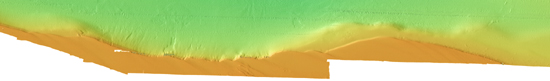
Channel Islands slope west |
Perspective view from the northwest of Channel IIslands http://www.mbari.org/data/mapping/SBBasin/channel_west.htm- |
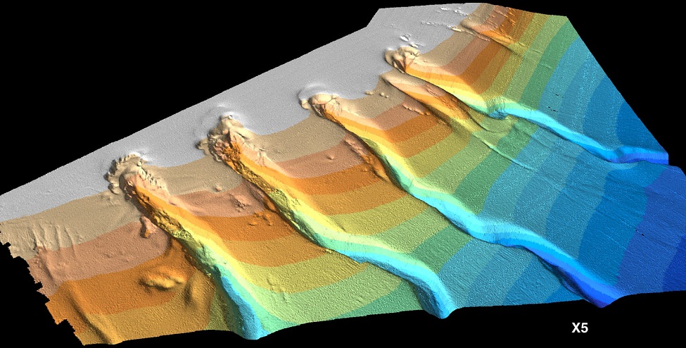
Arguello Canyons A, B, C, D -view from the west-http://www.mbari.org/data/mapping/SBBasin/images/santabarbD_bath.jpg |
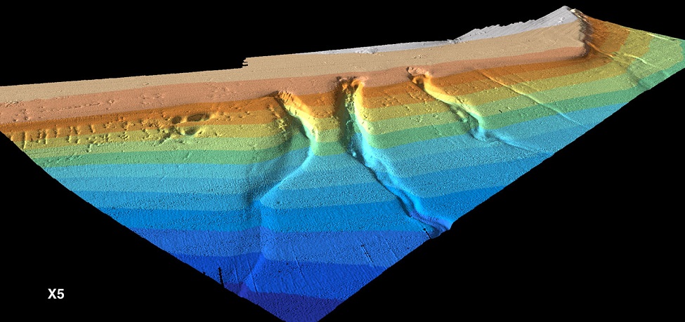
Point Concepcion Canyons A, B, C- http://www.mbari.org/data/mapping/SBBasin/images/santabarbarae_perspective.jpg |
Santa Barbara Basin -http://www.mbari.org/data/mapping/SBBasin/basin.htm |
Santa Barbara Anticline -http://www.mbari.org/data/mapping/SBBasin/anticline.htm |
Santa Barbara Anticline perspective view from the southeast |
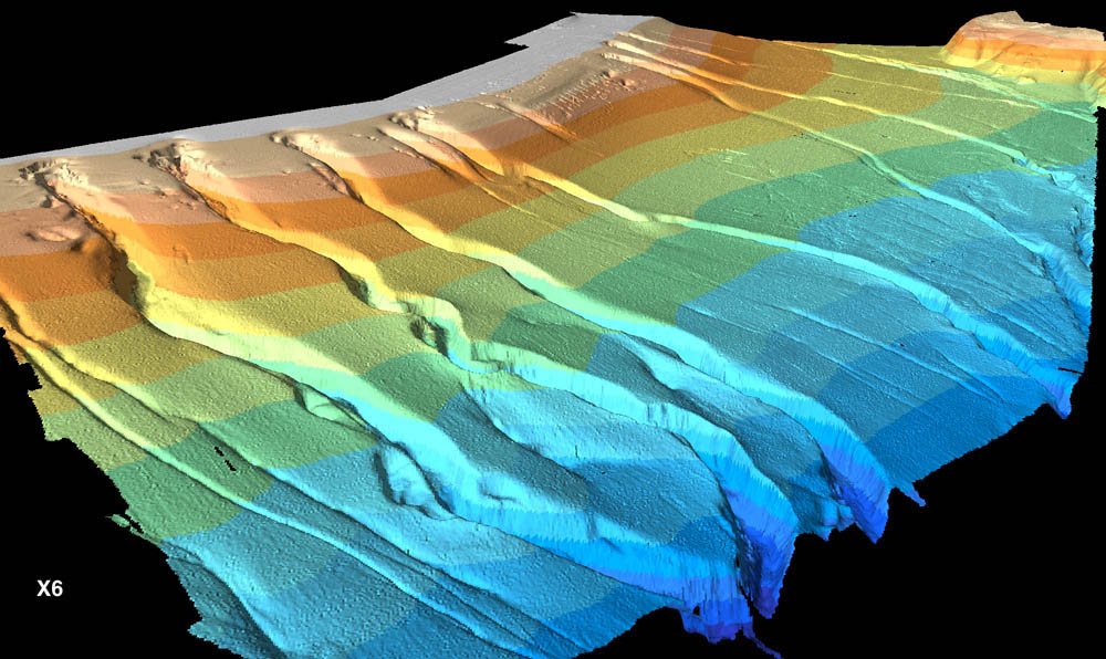
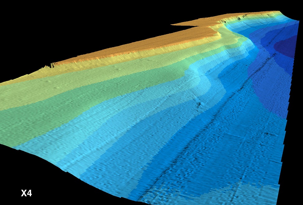
The eastern flank of the Santa Barbara Basin forms the northern flanks of the Channel Islands of Santa Cruz and Santa Rosa. The physiography here is comprised of a series of terraces that are well displayed in the EM300 multibeam data set. The terraces die off toward the west. The shelf break north of the Channel Islands follows the 100 m depth contour and is thus on average 20 m lower compared to the mainland shelf edge. The shelf is characterized by northwest-southeast trending elongate ridges, with a characteristic amplitude of about 5 m and a wavelength of about 2000 m. Several slides originate along the shelf edge north of Santa Rosa Island (central and western section of above figure) extending for about 2 km to the north of the shelf edge-http://www.mbari.org/data/mapping/SBBasin/images/santabarbH_bath.jpg |
Channel Islands slope, perspective view from the east -http://www.mbari.org/data/mapping/SBBasin/channel_east.htm |
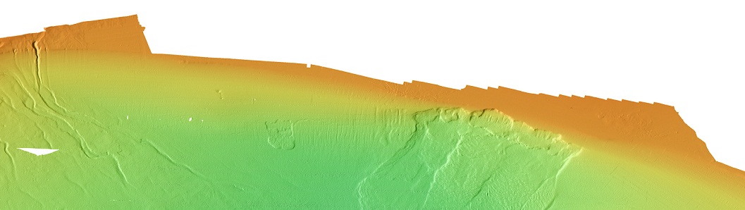
Offshore of Goleta-http://www.mbari.org/data/mapping/SBBasin/images/santabarbF_bath.jpg |
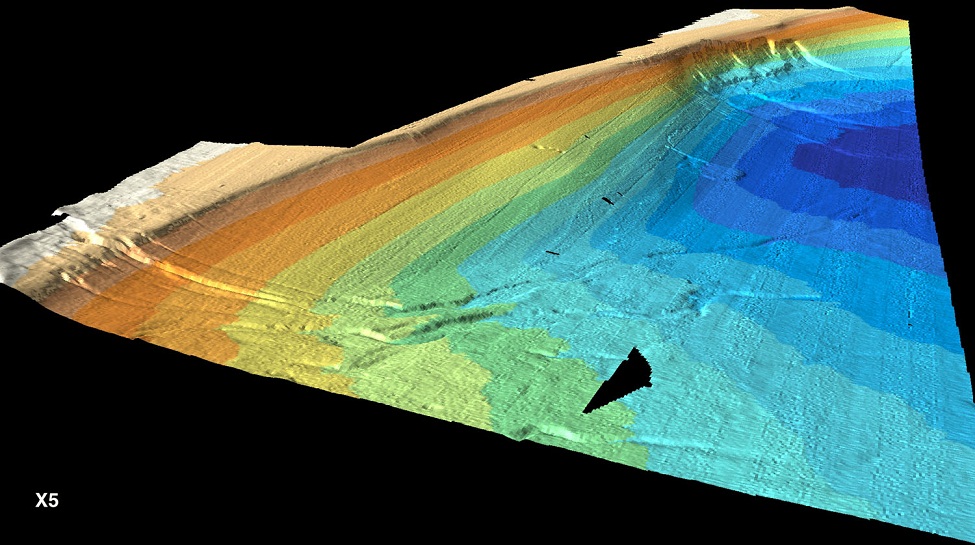
Goleta -Perspective view from the west |
http://www.mbari.org/data/mapping/SBBasin/images/santabarbarac_perspective.jpg |


From MBARI -http://www.mbari.org/data/mapping/SBBasin/default.htm
http://www.mbari.org/data/mapping/SBBasin/arguello.htm
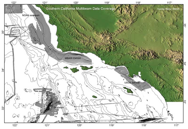
The swath data have been deposited at the National Geophysical Data Center (NGDC) and are available there for free download. A CD-ROM set that contains images and grids for use with GIS was compiled and is available from MBARI. The Mapping Team includes Nancy Barr, David Caress, David Clague, Peter Eichhubl, H. Gary Greene, and Norman Maher, all from the Monterey Bay Aquarium Research Institute (MBARI). The data were collected by Gerry Hatcher and Norman Maher from MBARI and the mapping crew from C&C Technologies
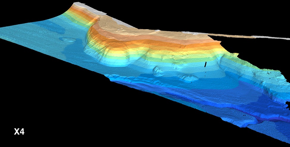
At the southern end of the western Santa Barbara Basin sill, a rounded lobe-like bedrock spur projects out and northwestward from the northern flank of the Channel Islands ridge. Apparent uplift of this spur appears to have pushed the course of Drake Canyon to the west where it joins the lower part of Concepcion Canyon C. The upper part of the spur appears to be terraced or to be composed of flat-bedded outcrops. The lower northern part of the spur is smooth and exhibits high backscatter whereas a steep, well-eroded scarp forms the lower northeastern part of the spur. Between the lower western part of the spur and the braided-like drainage of Drake Canyon, a fairly hummocky high backscatter seafloor exists with two prominent mounds rising above an otherwise flat seafloor to the west.- http://www.mbari.org/data/mapping/SBBasin/channel_west.htm
http://www.mbari.org/data/mapping/SBBasin/images/santabarbD_bath.jpg
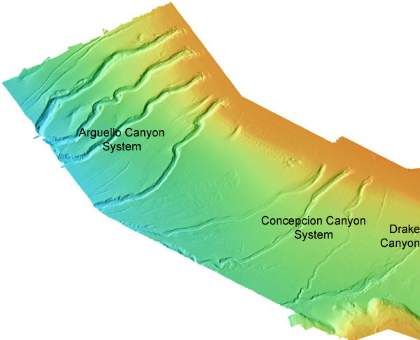
The four well- defined, mature canyons of the Arguello Canyon system are here named Arguello Canyon A, Arguello Canyon B, Arguello Canyon C, and Arguello Canyon D, from north to south. Each of these canyons exhibits unique and similar head morphologies that suggest collapse structures. These heads all notch the distal edge of the continental shelf in about 100 meters depth of water. They are located near or over the southwestern margin of the Santa Maria Basin, a major hydrocarbon basin. Interestingly, the best-developed collapsed canyon head morphology is located at Arguello Canyon B, the closest canyon head to the Santa Maria Basin, and the least developed is located at Arguello Canyon D. The EM300 bathymetric images show that all four canyons have detritus lobes that flow down canyon from the heads; these appear to represent evacuated material from beneath the collapsed heads. Along the downslope margins of the canyons, down-dropped walls and slump material indicate sediment failures occur regularly downslope. These canyons are quite sinuous and it appears that these bends result from mid-slope canyon wall failure.
The two immature canyons that flank Arguello Canyon D appear to result from top-down sediment transport processes. This is best illustrated with the developing canyon head just northwest of Arguello Canyon C where a gully appears just beneath the broad V-shaped head feature.
The gully west of Arguello Canyon A appears to originate in an amphitheater-like feature composed of parallel and converging rilles. Linear depressions and mounds are aligned parallel and sub-parallel to the canyons and gullies. These are especially prominent in the vicinity of Arguello Canyon D. Authigenic carbonate deposits have been collected at the heads of some of these canyons. It is speculated that the collapse heads, rilles, depressions and mounds are fluid-induced, possibly by escaping gas and fluids associated with the offshore hydrocarbon-rich Santa Maria Basin.
http://www.mbari.org/data/mapping/SBBasin/pt_concepcion.htm
The three fairly well-defined mature canyons that make up the Concepcion Canyon system are here called Concepcion Canyon A, Concepcion Canyon B, and Concepcion Canyon C, from west to east. Like the Arguello Canyons, the heads of these canyons exhibit collapsed-like geomorphology, although not as well developed as in the Arguello Canyon system. Both Concepcion Canyon A and Concepcion Canyon B have down-canyon moving debris lobes that appear to represent evacuated material from beneath the canyonÆs heads. The head of Concepcion Canyon C shows what appears to be the initial stage of a down-canyon debris flow. The best-developed collapse canyon head of these canyons is Concepcion Canyon B. All three heads notch the distal edge of the continental shelf at 100 m water depth. Unlike the Arguello Canyons, lateral failure along the downslope walls of the Concepcion Canyons are not very well developed.
One gully appears east of Concepcion Canyon C and may be an incipient canyon. Several linear depressions are located along the slope beneath the distal edge of the shelf and are oriented parallel or sub-parallel to the canyons. In addition, a series of collapse features exist west of Concepcion Canyon A and may represent an incipient canyon formation.
Drake Canyon, located east of Point Concepcion, heads at the shelf break in about 100 meters water depth. Its upper part is not well defined, but its lower part is sharp in morphology and connects with the lower part of Concepcion Canyon C.
http://www.mbari.org/data/mapping/SBBasin/channel_west.htm
At the southern end of the western Santa Barbara Basin sill, a rounded lobe-like bedrock spur projects out and northwestward from the northern flank of the Channel Islands ridge. Apparent uplift of this spur appears to have pushed the course of Drake Canyon to the west where it joins the lower part of Concepcion Canyon C. The upper part of the spur appears to be terraced or to be composed of flat-bedded outcrops. The lower northern part of the spur is smooth and exhibits high backscatter whereas a steep, well-eroded scarp forms the lower northeastern part of the spur. Between the lower western part of the spur and the braided-like drainage of Drake Canyon, a fairly hummocky high backscatter seafloor exists with two prominent mounds rising above an otherwise flat seafloor to the west
http://www.mbari.org/data/mapping/SBBasin/anticline.htm
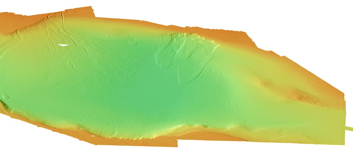
The eastern section of the Santa Barbara Basin is characterized by a morphologic and structural high, known as Mid-Channel trend or Twelve-Mile Reef. The Mid-Channel trend exposes Pliocene to Pleistocene units (M. Kamerling, UC Santa Barbara, pers. comm. 2000) and has been interpreted as an anticline that is bound by eastsoutheast-westnorthwest trending faults of the Oak Ridge fault system (Kamerling et al., 1998).Its westernmost extension is covered by the Goleta slide that extends from the shelf break along the 100 m contour down to the 570 m depth contour (Greene et al., in preparation). The anticline plunges to the west and appears to dive beneath the Goleta slide.
The Mid-Channel trend is characterized by fault scarps, sea stacks, and pockmarks. Pockmarks on the western segment of the Mid-Channel trend are aligned parallel to the eastsoutheast-westnorthwest structural grain suggesting a structural control of pockmark formation.
The basin fill consists of an 8-10 km thick Upper Jurassic to Holocene sedimentary sequence of sand-, silt-, and mudstone that increases to about 14 km in the onshore Ventura part, overlying the Jurassic accretionary sequence of the Franciscan Formation (Dibblee, 1982a, b; Dickinson et al., 1987; Kennedy et al., 1987). Marine sedimentation ended in the eastern Ventura basin during late Pleistocene times (Greene, 1976; Dibblee, 1982b) but continues in the modern offshore section of the basin.
The Santa Barbara Basin forms the foreland of the southward propagating deformation front of the Santa Ynez Mountains, with some of the highest known rates of active tectonic shortening and uplift measured in the Ventura area (Lajoie et al., 1982; Rockwell et al., 1988; Sylvester, 2000). Several of the faults in the mapped area such as the Oak Ridge, South Santa Ynez, Santa Cruz Island, and North Channel Slope faults are considered seismically active (Greene, 1976; Bortugno, 1977; Yerkes et al., 1981; Pinter and Sorlien, 1991; Jennings, 1994).
The Santa Barbara Basin is characterized by a distinct coastal shelf along the mainland and channel islands. The mainland shelf is widest in the eastern part of the channel, narrows west of Gaviota to 4.5 km and widens again forming an 8 km wide promontory southeast of Point Conception. The island shelf is up to 10 km wide.
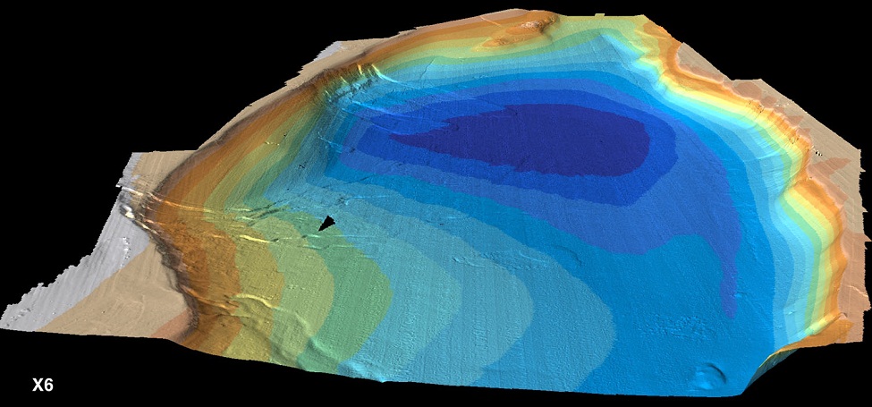
Note: The triangular "hole" in the basin image is where an oil drilling rig is located. The survey ship cut a wide path around the drilling rig, so there is no data from that area.
Anticline
The eastern section of the Santa Barbara Basin is characterized by a morphologic and structural high, known as Mid-Channel trend or Twelve-Mile Reef. The Mid-Channel trend exposes Pliocene to Pleistocene units (M. Kamerling, UC Santa Barbara, pers. comm. 2000) and has been interpreted as an anticline that is bound by eastsoutheast-westnorthwest trending faults of the Oak Ridge fault system (Kamerling et al., 1998).Its westernmost extension is covered by the Goleta slide that extends from the shelf break along the 100 m contour down to the 570 m depth contour (Greene et al., in preparation). The anticline plunges to the west and appears to dive beneath the Goleta slide.
The Mid-Channel trend is characterized by fault scarps, sea stacks, and pockmarks. Pockmarks on the western segment of the Mid-Channel trend are aligned parallel to the eastsoutheast-westnorthwest structural grain suggesting a structural control of pockmark formation.
http://www.mbari.org/data/mapping/SBBasin/channel_east.htm
The eastern flank of the Santa Barbara Basin forms the northern flanks of the Channel Islands of Santa Cruz and Santa Rosa. The physiography here is comprised of a series of terraces that are well displayed in the EM300 multibeam data set. The terraces die off toward the west. The shelf break north of the Channel Islands follows the 100 m depth contour and is thus on average 20 m lower compared to the mainland shelf edge. The shelf is characterized by northwest-southeast trending elongate ridges, with a characteristic amplitude of about 5 m and a wavelength of about 2000 m. Several slides originate along the shelf edge north of Santa Rosa Island (central and western section of above figure) extending for about 2 km to the north of the shelf edge.
http://www.mbari.org/data/mapping/SBBasin/images/santabarbF_bath.jpg
The northern shelf of the Santa Barbara basin exposes bedrock at several locations. Folded and faulted strata of the Upper Miocene Monterey and Sisquoc Formations crop out on the shelf south of Goleta (eastern portion of above figure), where there are also extensive active hydrocarbon seeps (Fischer and Berry, 1973; Quigley et al., 1999). The shelf edge between Santa Barbara and Gaviota follows the 85 m depth contour.
The EM300 30 kHz multibeam bathymetric data show that the northern flank of the Santa Barbara Basin has experienced massive slope failures. The most prominent feature is the 134-km2 compound slump and debris flow associated with the Goleta landslide located off Coal Oil Point near Goleta. The Goleta slide is 14.6-km long, and is 10.5 km wide, extending from 90 m to nearly 574 m depth. The Goleta landslide is composed of distinct western, central and eastern segments, suggestive of multiple failure events. Each segment contains a well-defined head scarp, down-dropped head block and a slide debris lobe. The debris lobes exhibit hummocky topography in their central areas that appear to result from compression during down slope movement. The toes of the western and eastern lobes are well defined in the multibeam image, whereas the toe of the central lobe is less distinct and presumably older.
Several other smaller (2 km2 to 4 km2 in area) slides are located on the northern flank of the Santa Barbara Basin, both to the west and east of Goleta slide. One located west of the Goleta slide, named the Gaviota slide by Edwards et al. (1995) and Hampton et al. (1996), is 3.8 km2 in area and measures 2.6 km long and 1.7 km wide. A distinct narrow scar extends from near the eastern head wall of this slide over 2 km eastward toward the Goleta slide and may represent either an incipient failure or a remnant of a previous failure.
Concepcion fan, described by Kraemer (1986) and Fischer and Cherven (1998), consists of four major braided channels that extend into the basin to a water depth of about 580 m. The fan system originates within three canyons that incised into the shelf edge south of Gaviota
http://www.mbari.org/data/mapping/SBBasin/basin2.htm - mass wasting
http://www.mbari.org/data/mapping/SBBasin/slope_instability1.htm -
Slope Instability and the Potential for Tsunami Generating Landslides
H. Gary Greene , Norman Maher and Charlie Paull
Recently collected high-resolution multibeam bathymetric data along the active convergent continental margin of the northeastern Pacific have revealed numerous areas of past and potential sites of mass wasting. These features are examples of mass wasting events that may have produced tsunamis.
A number of landslide scars and deposits occur in several areas along the central California margin. One submarine landslide is offshore of Goleta, California, along the northern boundary of the Santa Barbara Basin. Here we have mapped a massive complex compound landslide that extends over an area of 134 km2. The Goleta slide has an overall width of about 10.5 km and a length of about 14.6 km that can be easily traced from its head scarp located in 90 m to its toe in 574 m of water. We estimate that the slide displaced ~1.75 km3 of material. The landslide scar is comprised of three distinct geomorphic components. Each component is made up of a steeper head scarp (47 to 75 m high and up to 24░ in inclination), a main scar (196 to 240 m high and inclined from 7-10░), a slump block (8.3x10⁻³ to 25x10-3 m3 in volume, averaging 20 m thick) and a relatively thin (7 to 12 m thick) extensive (26.3 to 44.7 km2 in area) debris flow deposits. The debris flow deposits exhibit surface textures of convex down-slope compression ridges with relief of 1 to 3 m. The relative sequence of movement for each of the three components can be estimated from cross-cutting relationships between discrete events. Although the EM300 multibeam images of the Goleta slide show sharp and well defined relief, indicating a youthful geomorphological age, the timing of failures is otherwise unknown.
Visual examination and sediment sampling were undertaken with MBARI''s ROV Ventana along a transect across the upper displaced mass, main scar and head scar of the middle component. This investigation indicated that the surface of the main scar consisted of stiff clay covered with unconsolidated mud. The headwall was coated with mud, shell hash and angular cobble- to small-boulder-size carbonate rocks, apparently derived from the upper head scarp and adjacent shelf edge.
Multibeam dat